Protected areas
Where the forest still keeps the spring
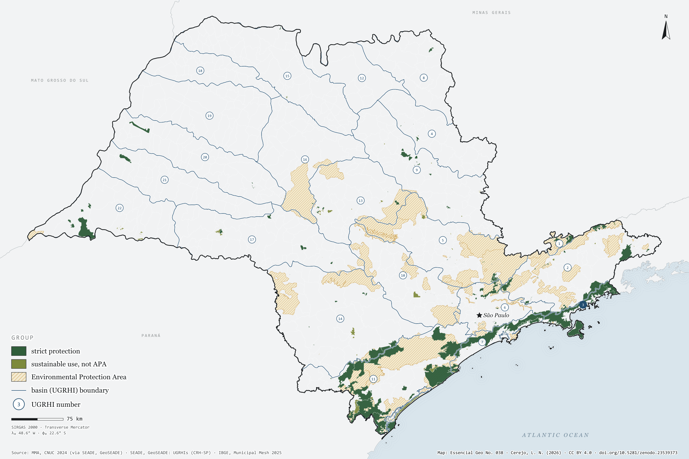
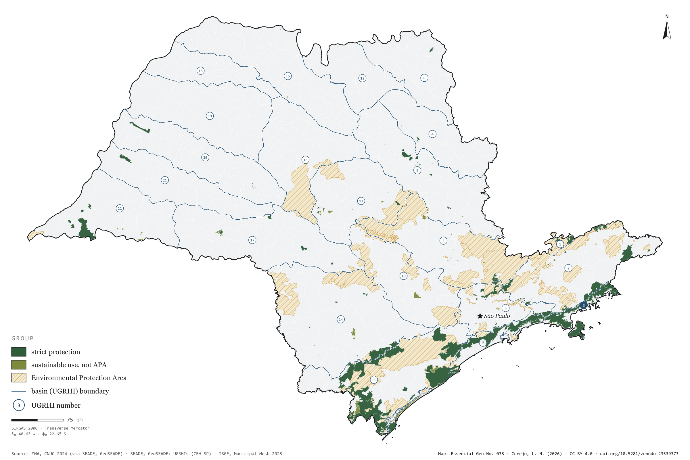
In the Litoral Norte, 73% of the basin lies in strictly protected areas, most of it in the Serra do Mar State Park. In the west of the state, three basins — Baixo Tietê, São José dos Dourados and Baixo Pardo/Grande — have none at all. Taken together, the 270 protected areas in the CNUC for São Paulo cover 15.1% of the territory, but only 4.0% under strict protection; nearly all the rest are Environmental Protection Areas, which allow settlement under rules. Over the 22 basins, the map shows where protected forest still keeps the springs: in the Serra do Mar and the Ribeira valley. Final plate of the collection “Water in São Paulo”.
Technical record · downloads · citation
At a glance
15 %
Layers
- unidades_conservacao polygon 270 protected areas: category, group, sphere, founding act and area in SP
- ugrhi polygon 22 UGRHIs with the area and share under strict protection and in any protected area
- limite_estadual polygon State boundary
Metadata
- Sources
- MMA — National Register of Protected Areas (CNUC), as published by GeoSEADE (2024)
SEADE — GeoSEADE: Water Resources Management Units (UGRHIs)
IBGE — Municipal Mesh 2025 (2025) - Extent
- São Paulo state (SP)
- CRS / Projection
- SIRGAS 2000 (EPSG:4674)
EPSG:4674 - Software
- Python · GeoPandas · GDAL · QGIS · Node.js · d3-geo
- Method
- CNUC protected areas clipped to São Paulo’s territory; areas dissolved so overlaps are not counted twice, and crossed with the 22 UGRHIs.
- Version
- v1.0.0
- Licence
- CC BY 4.0
Downloads
- GPKG Three layers, SIRGAS 2000, with QGIS styles (.gpkg) 5.6 MB
- CSV All 270 units, without geometry (.csv) 73 kB
- SVG Vector plate, for printing (.svg) 2.6 MB
- PNG Plate (PNG, 2400 px) (.png) 0.3 MB

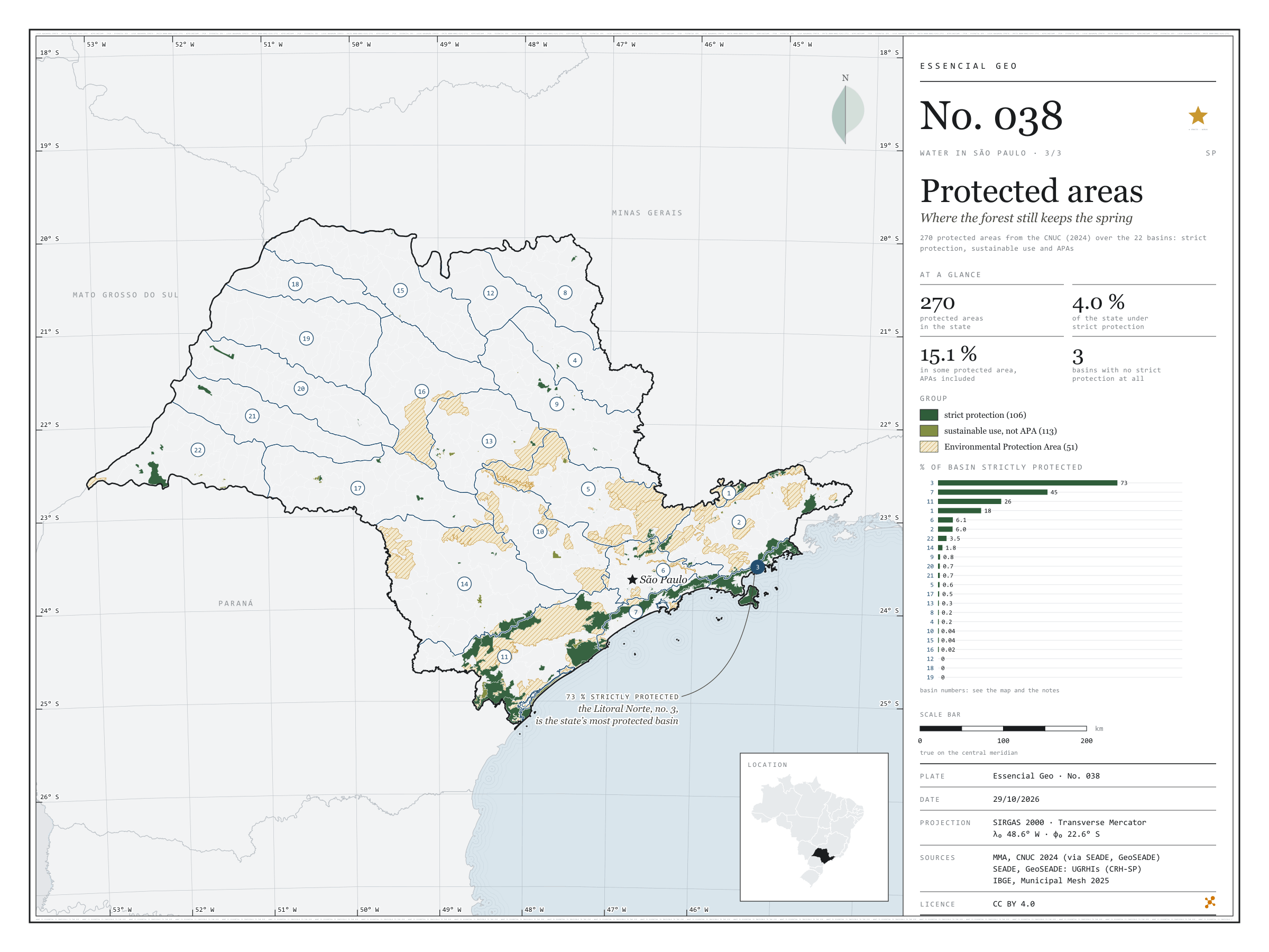
Figure to reuse
The map without a frame, with legend, scale, reference system and credit written on it: ready for papers, lectures and slides. In two versions: with the basemap (neighbours and sea) or only the mapped area, on white.
With basemap (PNG) Without basemap (PNG) QR code (SVG)
Point a camera at it to open this page.
How to cite
CEREJO, Lucas Nakamura. Unidades de conservação: onde a floresta ainda guarda a nascente. Versão 1.0.0. [S. l.]: Zenodo, 2026. Conjunto de dados. DOI: 10.5281/zenodo.23539373. Disponível em: https://doi.org/10.5281/zenodo.23539373. Acesso em: 10 nov. 2026.
Cerejo, L. N. (2026). Unidades de conservação: onde a floresta ainda guarda a nascente [Protected areas: Where the forest still keeps the spring] (Version 1.0.0) [Data set]. Zenodo. https://doi.org/10.5281/zenodo.23539373
@dataset{cerejo2026_unidades_de_conservacao_sp,
  author    = {Cerejo, Lucas Nakamura},
  title     = {Unidades de conservação: Onde a floresta ainda guarda a nascente},
  year      = {2026},
  publisher = {Zenodo},
  version   = {1.0.0},
  doi       = {10.5281/zenodo.23539373},
  url       = {https://doi.org/10.5281/zenodo.23539373},
  language  = {portuguese},
  note      = {English title: Protected areas: Where the forest still keeps the spring. Licence CC BY 4.0}
}