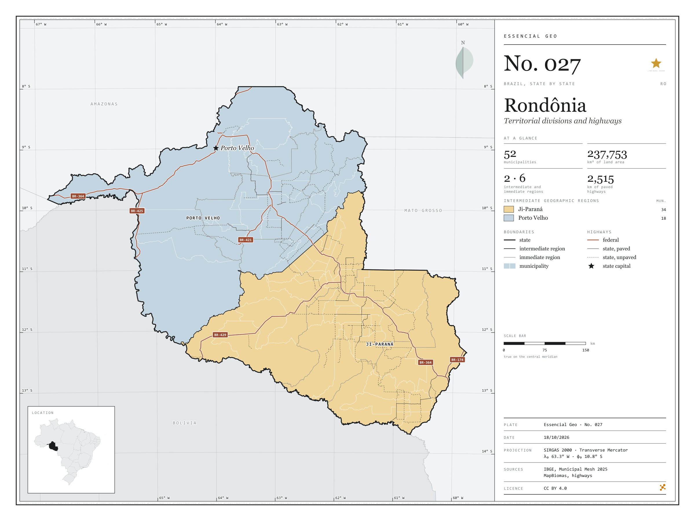
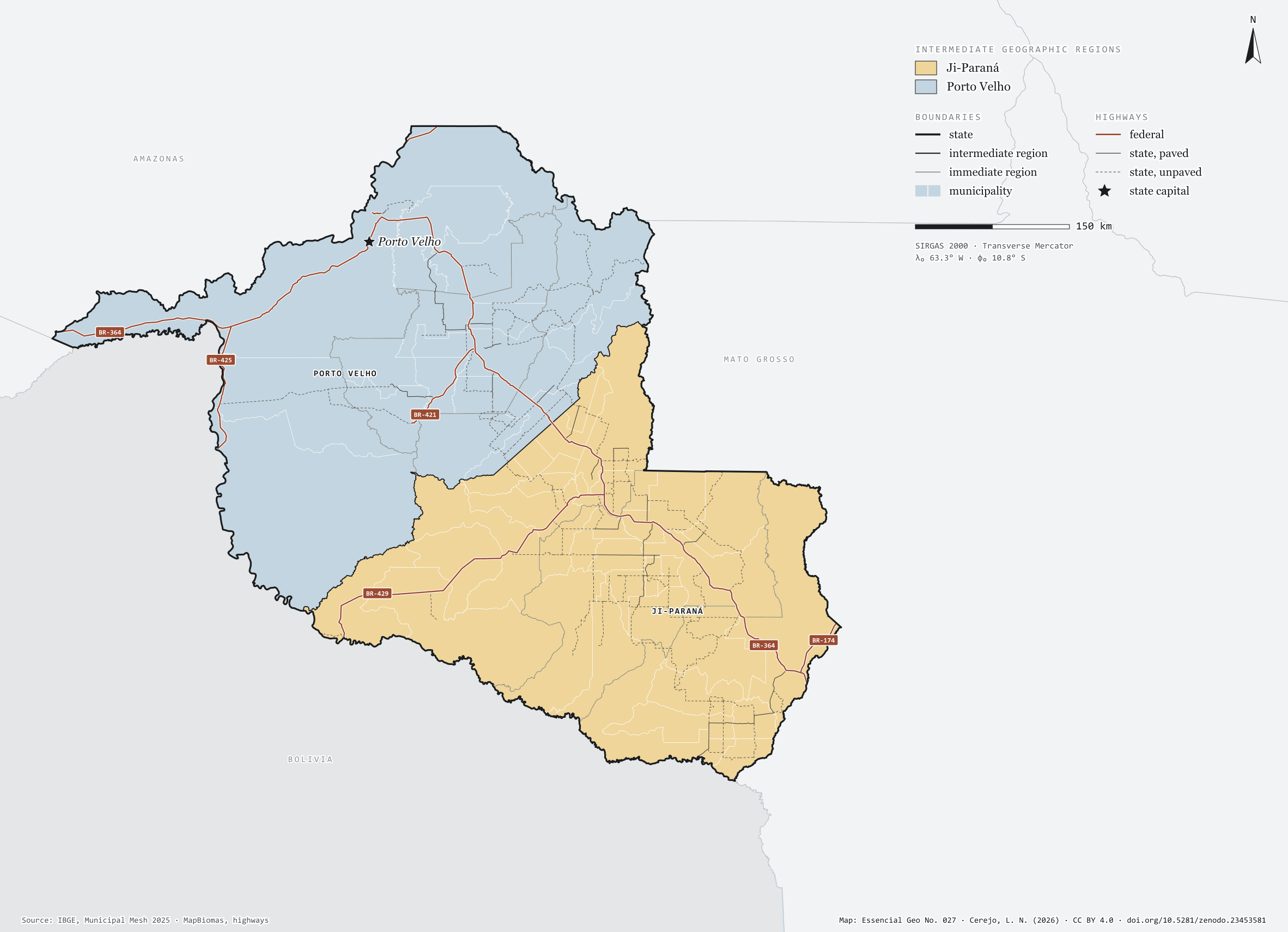
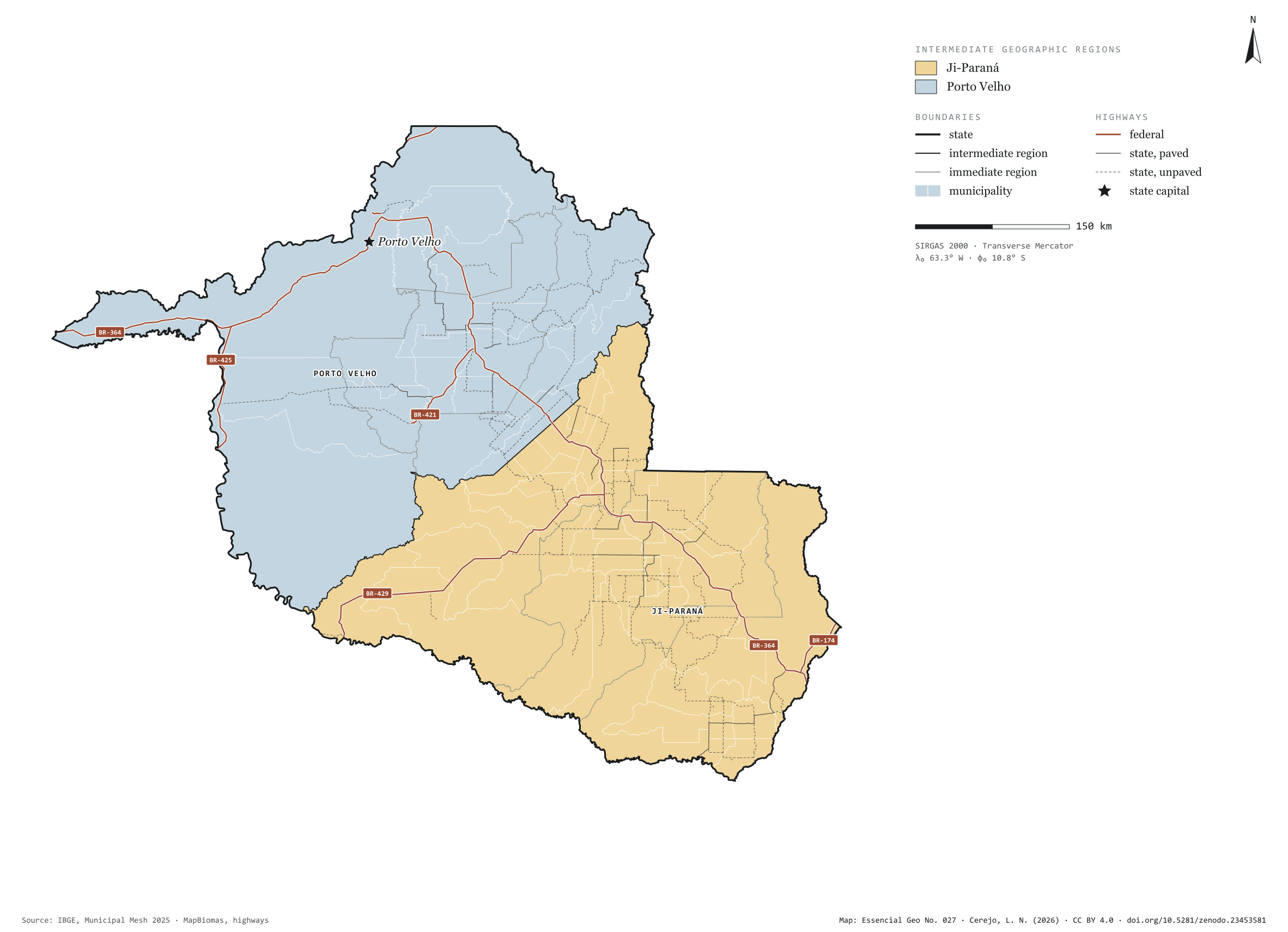
Fig. 027Rondônia state (RO)EPSG:4674Source: IBGE, MapBiomas, Natural Earth
Rondônia has 52 municipalities across 238,000 km², 2.8 per cent of Brazil. IBGE groups them into 6 immediate regions, drawn around the towns that supply jobs, trade and services to their surroundings, and into 2 intermediate regions that tie those networks together. Ji-Paraná is the intermediate region with the most municipalities (34); Porto Velho, the one with the fewest (18). The largest municipality is Porto Velho (34,091 km²); the smallest, Teixeirópolis (460 km²). Part of the series “Brazil, state by state”: a clean base, with official boundaries and the road network, to start a map without losing the first afternoon gathering files.
Technical record · downloads · citation
At a glance
Municipalities per intermediate region (municipalities)
Ji-Paraná34
Porto Velho18
Area
237,753km²
Largest municipality: Porto Velho (34,091 km²); smallest: Teixeirópolis (460 km²)
Paved highways
2,515km
1,775 km federal and 4,507 km state highways, paved or not
Layers
municipiospolygon52 municipalities, with IBGE code, regions, urban concentration and area (km²)
regioes_intermediariaspolygon2 intermediate geographic regions
regioes_imediataspolygon6 immediate geographic regions
limite_estadualpolygonBoundary of the federative unit
rodoviaslineFederal and state highways: route number, surface, physical status, carriageways
capitalpointIndicative point for the capital (not the exact seat)
The map without a frame, with legend, scale, reference system and credit written on it: ready for papers, lectures and slides. In two versions: with the basemap (neighbours and sea) or only the mapped area, on white.
CEREJO, Lucas Nakamura. Rondônia: divisão territorial e rodovias. Versão 1.0.0. [S. l.]: Zenodo, 2026. Conjunto de dados. DOI: 10.5281/zenodo.23453581. Disponível em: https://doi.org/10.5281/zenodo.23453581. Acesso em: 10 nov. 2026.
Cerejo, L. N. (2026). Rondônia: divisão territorial e rodovias [Rondônia: Territorial divisions and highways] (Version 1.0.0) [Data set]. Zenodo. https://doi.org/10.5281/zenodo.23453581
@dataset{cerejo2026_estado_rondonia,
  author    = {Cerejo, Lucas Nakamura},
  title     = {Rondônia: Divisão territorial e rodovias},
  year      = {2026},
  publisher = {Zenodo},
  version   = {1.0.0},
  doi       = {10.5281/zenodo.23453581},
  url       = {https://doi.org/10.5281/zenodo.23453581},
  language  = {portuguese},
  note      = {English title: Rondônia: Territorial divisions and highways. Licence CC BY 4.0}
}
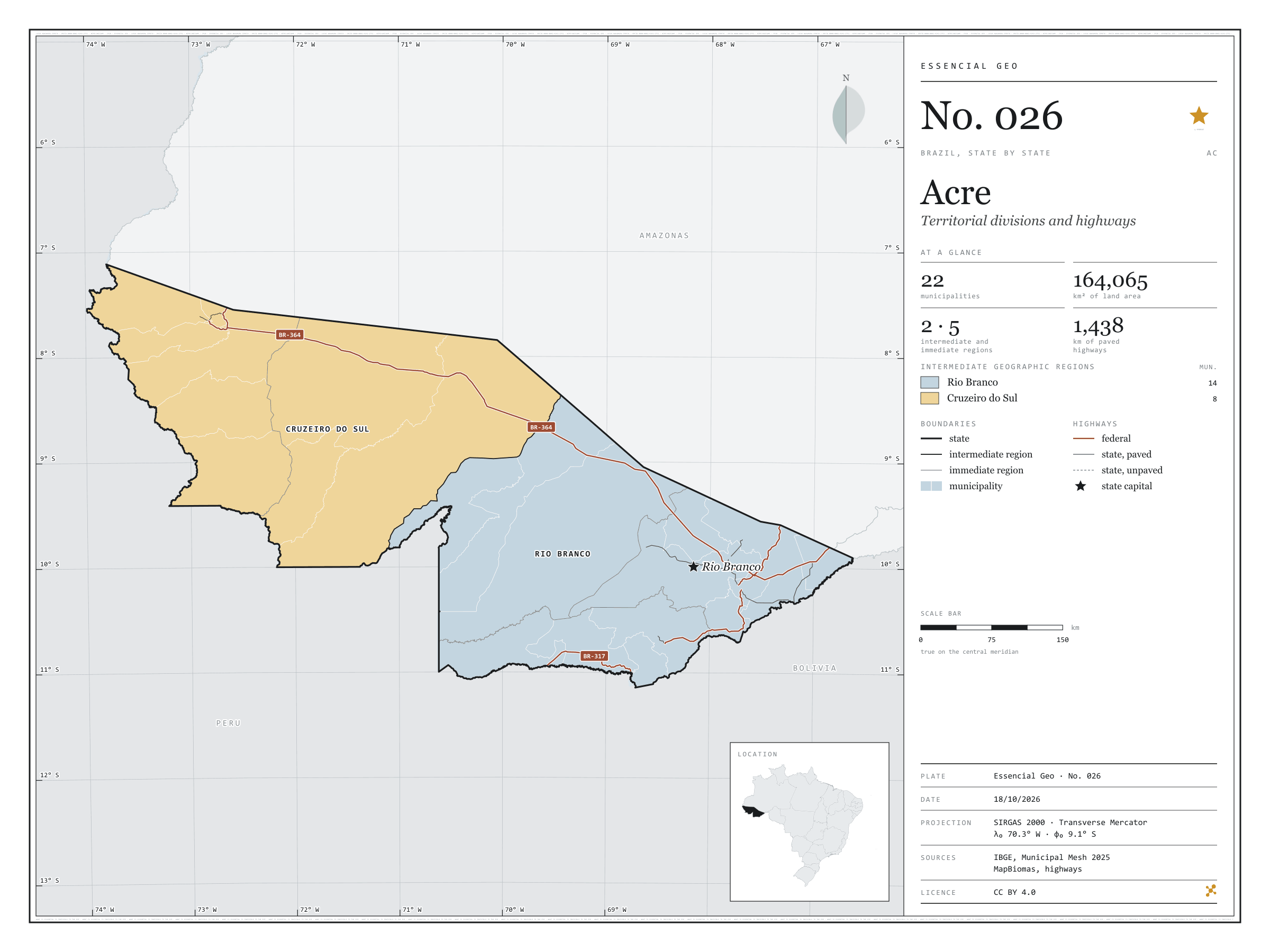
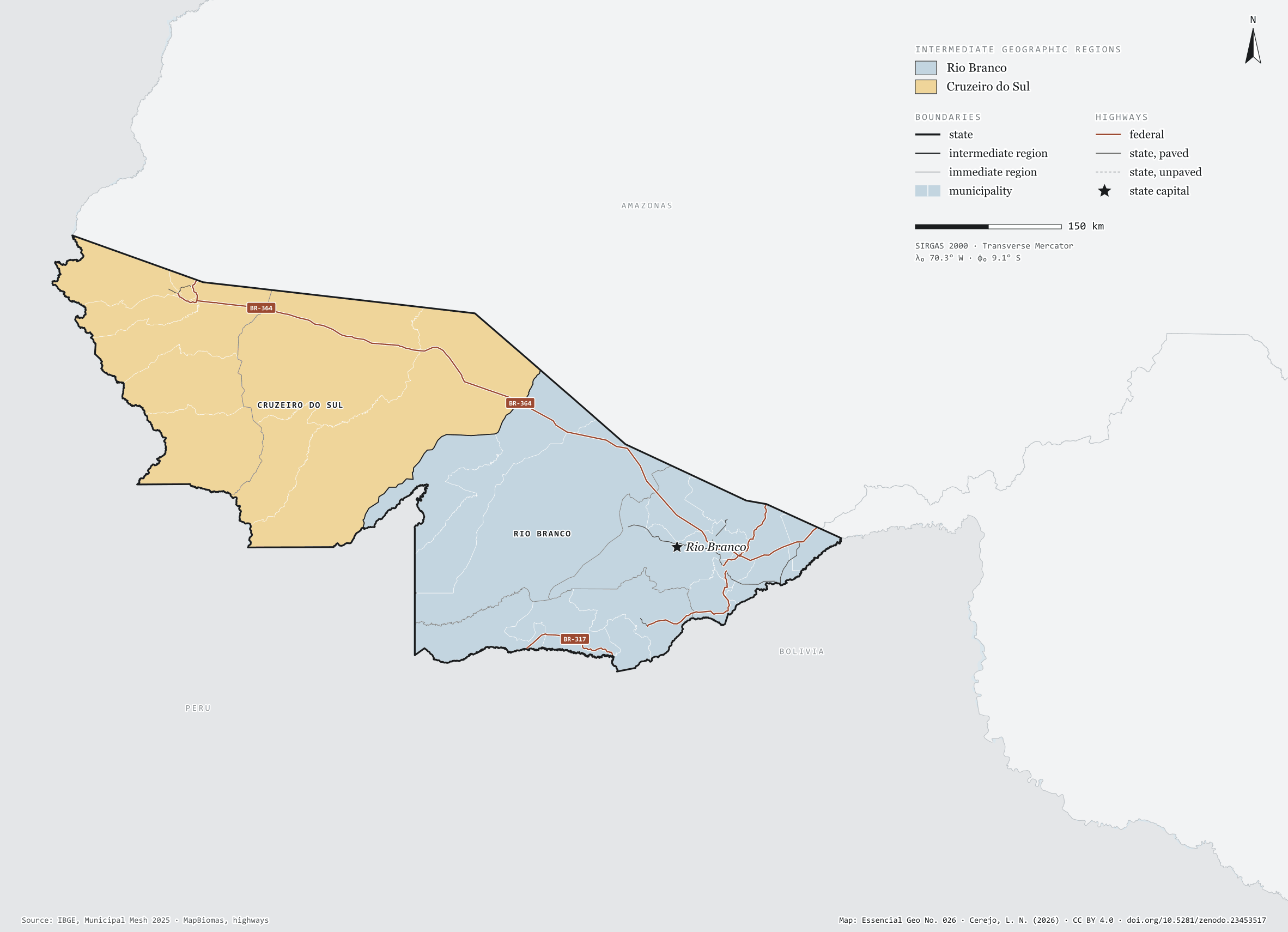
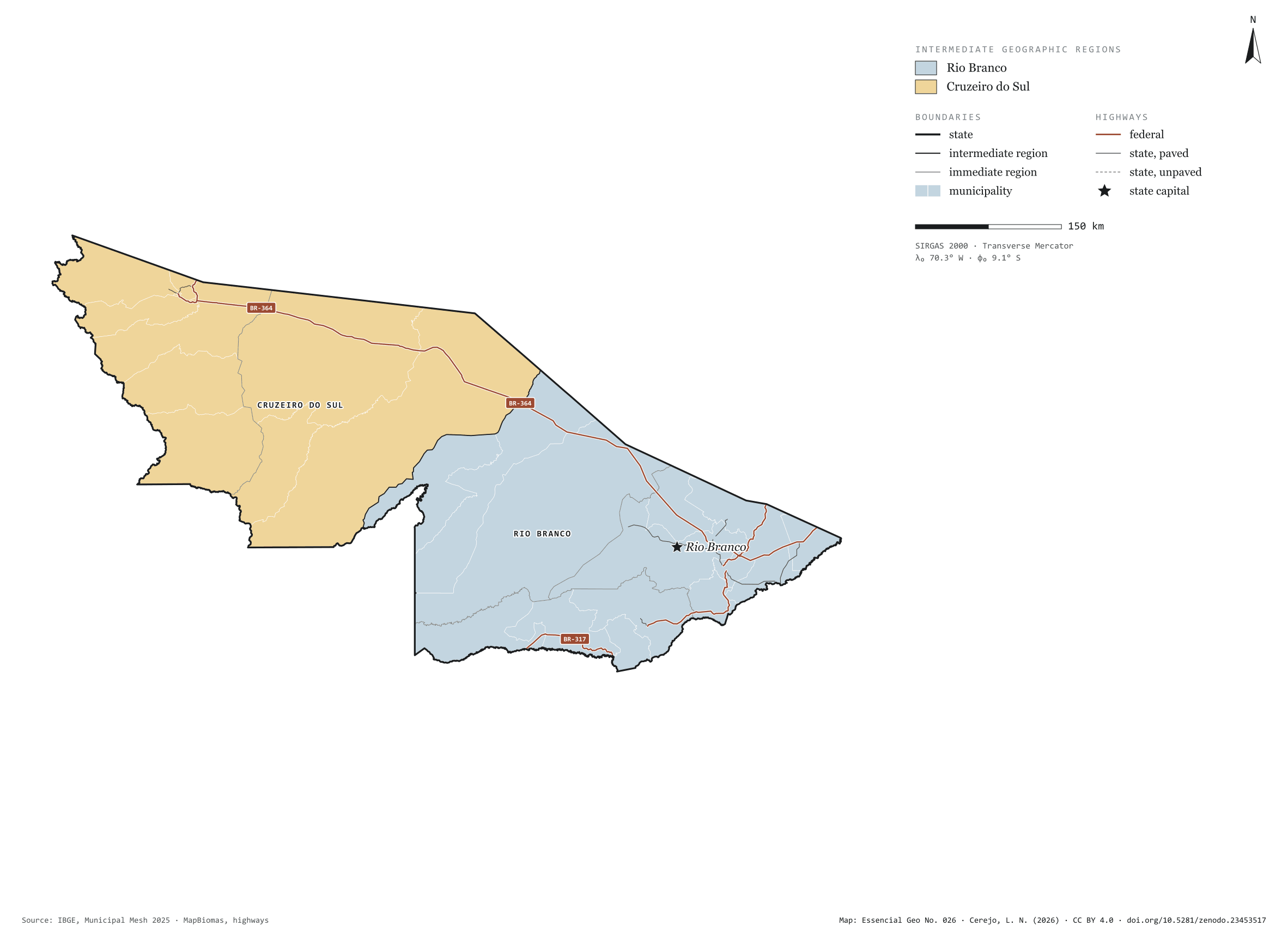
Fig. 026Acre state (AC)EPSG:4674Source: IBGE, MapBiomas, Natural Earth
Acre has 22 municipalities across 164,000 km², 1.9 per cent of Brazil. IBGE groups them into 5 immediate regions, drawn around the towns that supply jobs, trade and services to their surroundings, and into 2 intermediate regions that tie those networks together. Rio Branco is the intermediate region with the most municipalities (14); Cruzeiro do Sul, the one with the fewest (8). The largest municipality is Feijó (27,947 km²); the smallest, Epitaciolândia (1,653 km²). Part of the series “Brazil, state by state”: a clean base, with official boundaries and the road network, to start a map without losing the first afternoon gathering files.
Technical record · downloads · citation
At a glance
Municipalities per intermediate region (municipalities)
Rio Branco14
Cruzeiro do Sul8
Area
164,065km²
Largest municipality: Feijó (27,947 km²); smallest: Epitaciolândia (1,653 km²)
Paved highways
1,438km
1,135 km federal and 303 km state highways, paved or not
Layers
municipiospolygon22 municipalities, with IBGE code, regions, urban concentration and area (km²)
regioes_intermediariaspolygon2 intermediate geographic regions
regioes_imediataspolygon5 immediate geographic regions
limite_estadualpolygonBoundary of the federative unit
rodoviaslineFederal and state highways: route number, surface, physical status, carriageways
capitalpointIndicative point for the capital (not the exact seat)
The map without a frame, with legend, scale, reference system and credit written on it: ready for papers, lectures and slides. In two versions: with the basemap (neighbours and sea) or only the mapped area, on white.
CEREJO, Lucas Nakamura. Acre: divisão territorial e rodovias. Versão 1.0.0. [S. l.]: Zenodo, 2026. Conjunto de dados. DOI: 10.5281/zenodo.23453517. Disponível em: https://doi.org/10.5281/zenodo.23453517. Acesso em: 10 nov. 2026.
Cerejo, L. N. (2026). Acre: divisão territorial e rodovias [Acre: Territorial divisions and highways] (Version 1.0.0) [Data set]. Zenodo. https://doi.org/10.5281/zenodo.23453517
@dataset{cerejo2026_estado_acre,
  author    = {Cerejo, Lucas Nakamura},
  title     = {Acre: Divisão territorial e rodovias},
  year      = {2026},
  publisher = {Zenodo},
  version   = {1.0.0},
  doi       = {10.5281/zenodo.23453517},
  url       = {https://doi.org/10.5281/zenodo.23453517},
  language  = {portuguese},
  note      = {English title: Acre: Territorial divisions and highways. Licence CC BY 4.0}
}
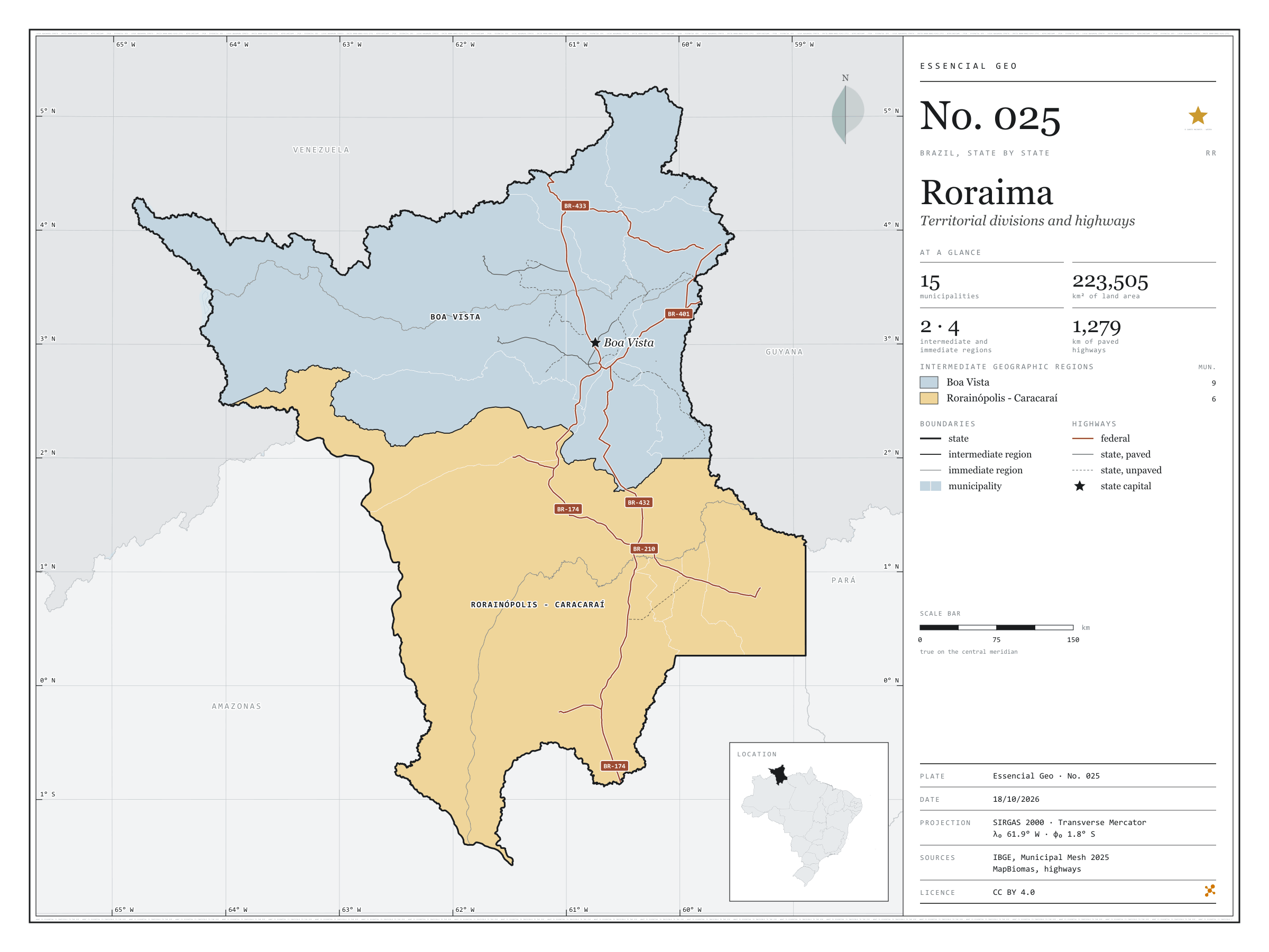
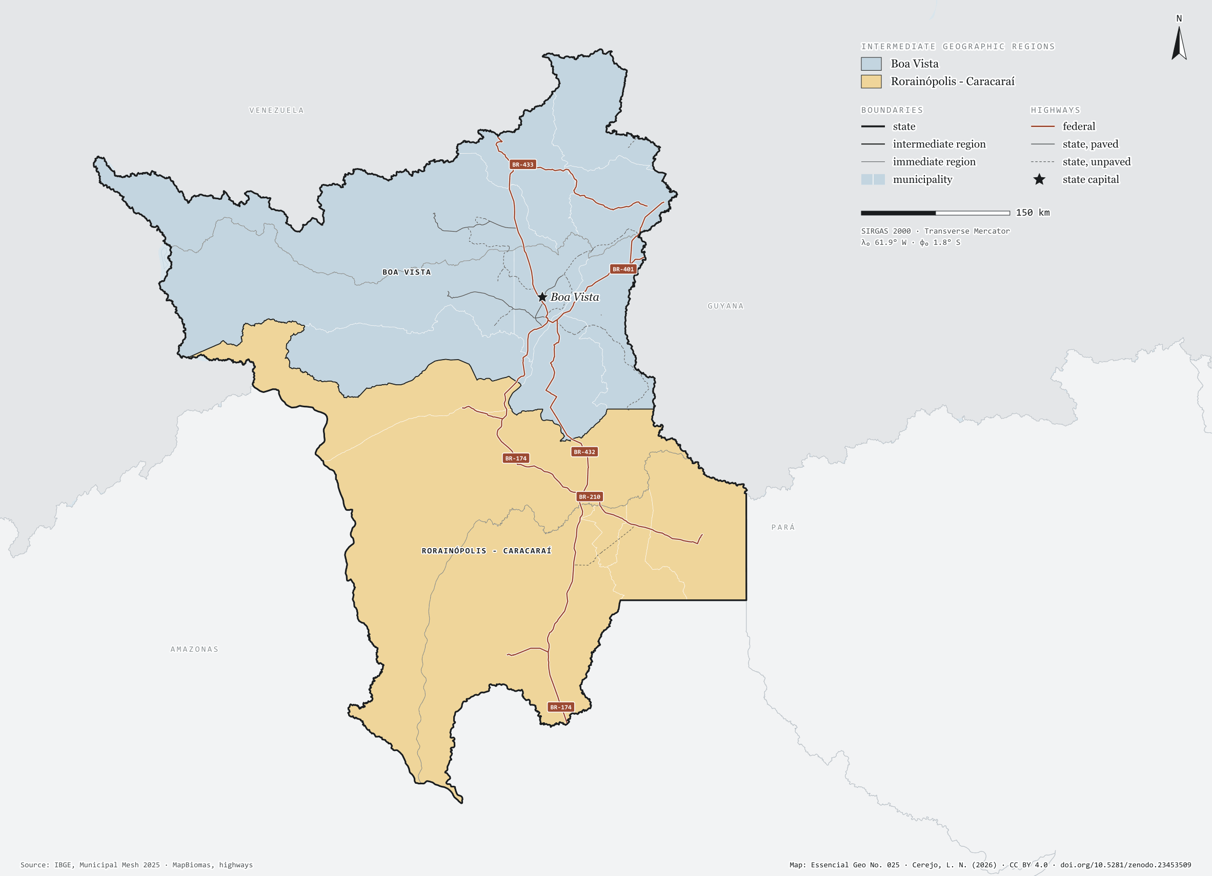
Fig. 025Roraima state (RR)EPSG:4674Source: IBGE, MapBiomas, Natural Earth
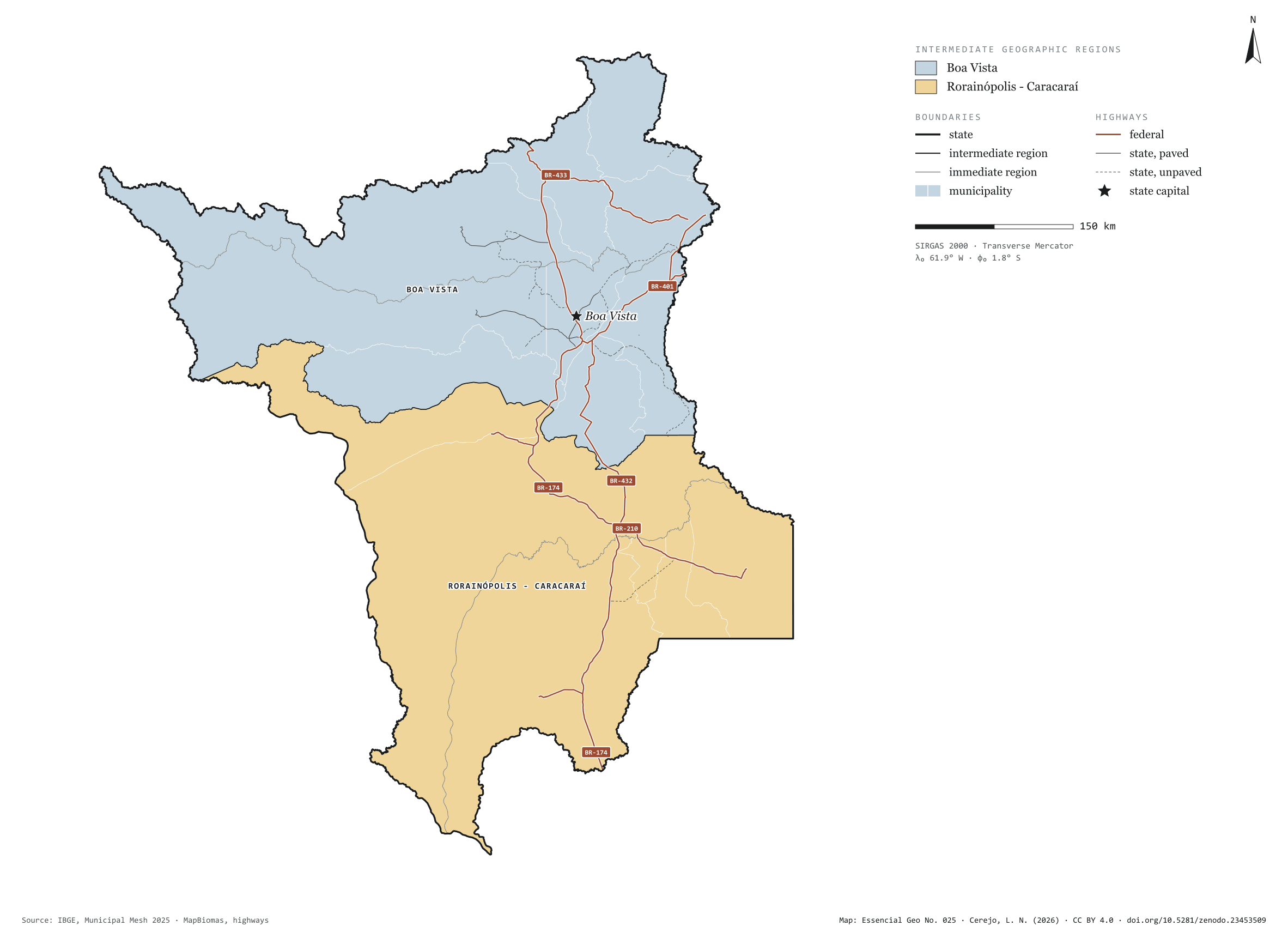
Roraima has 15 municipalities across 224,000 km², 2.6 per cent of Brazil. IBGE groups them into 4 immediate regions, drawn around the towns that supply jobs, trade and services to their surroundings, and into 2 intermediate regions that tie those networks together. Boa Vista is the intermediate region with the most municipalities (9); Rorainópolis - Caracaraí, the one with the fewest (6). The largest municipality is Caracaraí (47,385 km²); the smallest, São Luiz do Anauá (1,527 km²). Part of the series “Brazil, state by state”: a clean base, with official boundaries and the road network, to start a map without losing the first afternoon gathering files.
Technical record · downloads · citation
At a glance
Municipalities per intermediate region (municipalities)
Boa Vista9
Rorainópolis - Caracaraí6
Area
223,505km²
Largest municipality: Caracaraí (47,385 km²); smallest: São Luiz do Anauá (1,527 km²)
Paved highways
1,279km
1,528 km federal and 922 km state highways, paved or not
Layers
municipiospolygon15 municipalities, with IBGE code, regions, urban concentration and area (km²)
regioes_intermediariaspolygon2 intermediate geographic regions
regioes_imediataspolygon4 immediate geographic regions
limite_estadualpolygonBoundary of the federative unit
rodoviaslineFederal and state highways: route number, surface, physical status, carriageways
capitalpointIndicative point for the capital (not the exact seat)
The map without a frame, with legend, scale, reference system and credit written on it: ready for papers, lectures and slides. In two versions: with the basemap (neighbours and sea) or only the mapped area, on white.
CEREJO, Lucas Nakamura. Roraima: divisão territorial e rodovias. Versão 1.0.0. [S. l.]: Zenodo, 2026. Conjunto de dados. DOI: 10.5281/zenodo.23453509. Disponível em: https://doi.org/10.5281/zenodo.23453509. Acesso em: 10 nov. 2026.
Cerejo, L. N. (2026). Roraima: divisão territorial e rodovias [Roraima: Territorial divisions and highways] (Version 1.0.0) [Data set]. Zenodo. https://doi.org/10.5281/zenodo.23453509
@dataset{cerejo2026_estado_roraima,
  author    = {Cerejo, Lucas Nakamura},
  title     = {Roraima: Divisão territorial e rodovias},
  year      = {2026},
  publisher = {Zenodo},
  version   = {1.0.0},
  doi       = {10.5281/zenodo.23453509},
  url       = {https://doi.org/10.5281/zenodo.23453509},
  language  = {portuguese},
  note      = {English title: Roraima: Territorial divisions and highways. Licence CC BY 4.0}
}
Fig. 024Amazonas state (AM)EPSG:4674Source: IBGE, MapBiomas, Natural Earth
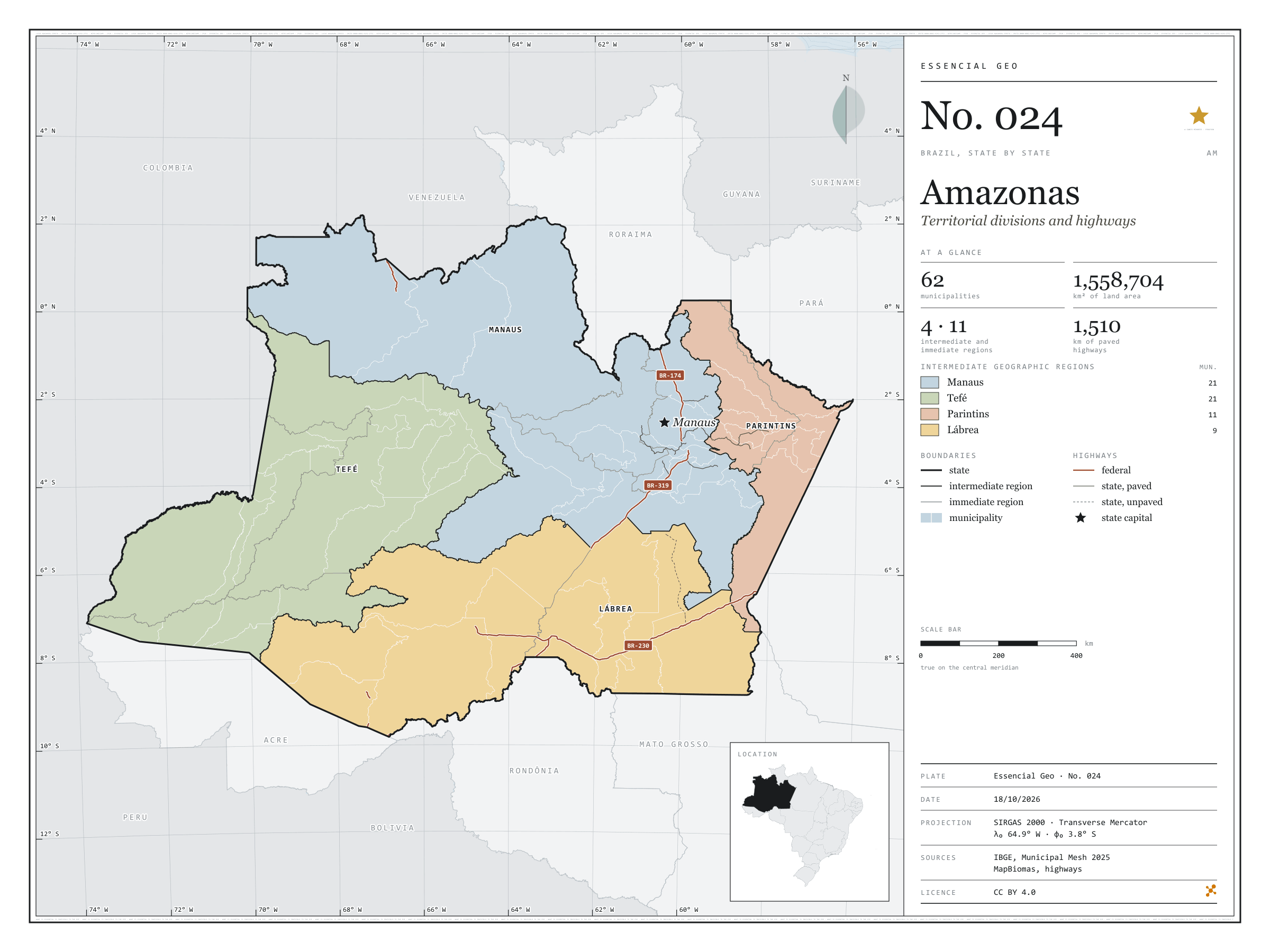
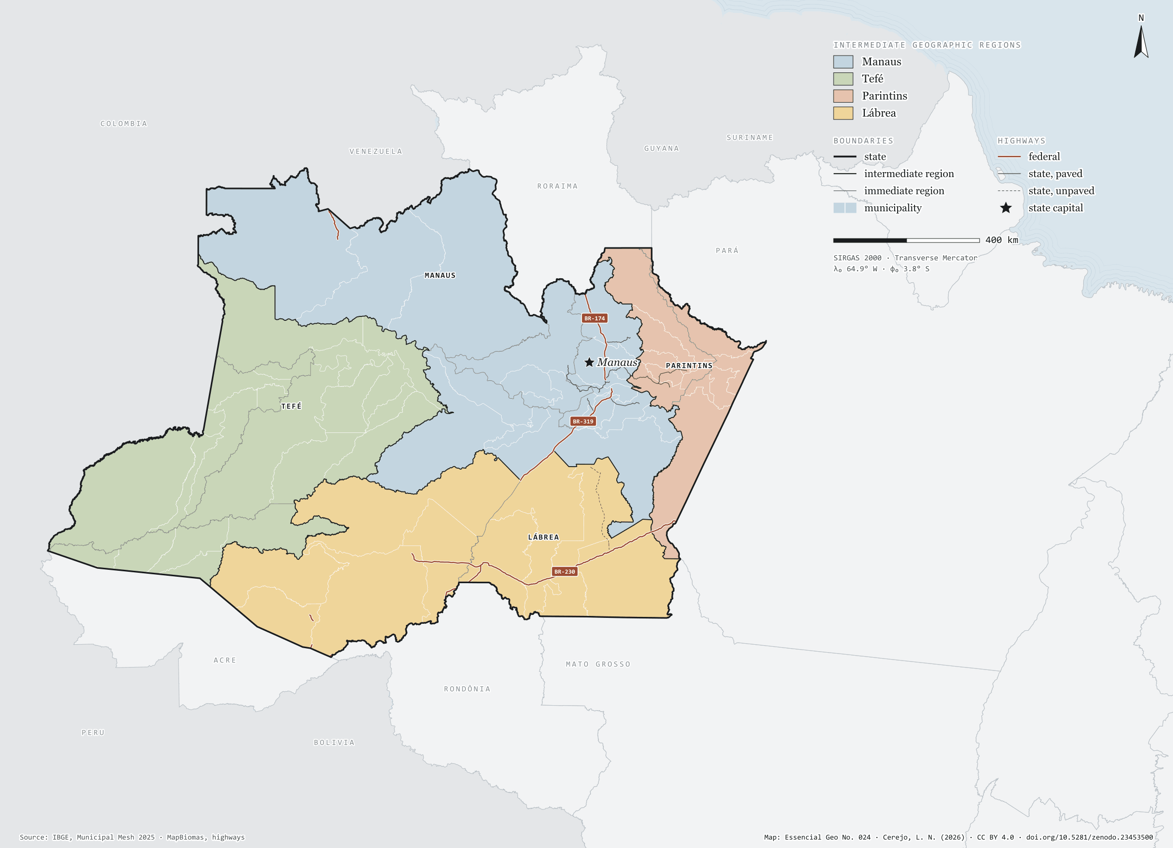
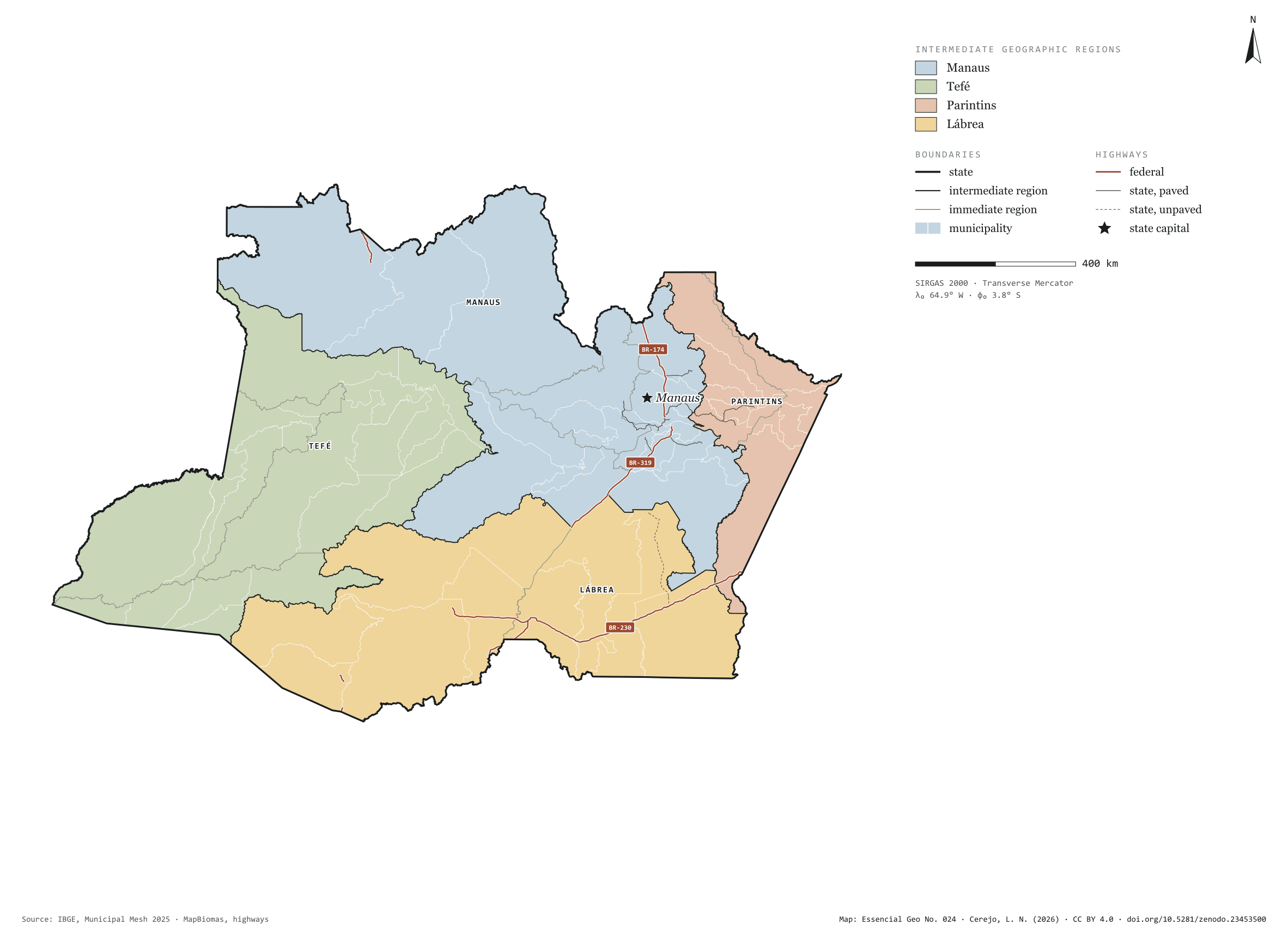
Amazonas has 62 municipalities across 1,559,000 km², 18.3 per cent of Brazil. IBGE groups them into 11 immediate regions, drawn around the towns that supply jobs, trade and services to their surroundings, and into 4 intermediate regions that tie those networks together. Manaus is the intermediate region with the most municipalities (21); Lábrea, the one with the fewest (9). The largest municipality is Barcelos (122,454 km²); the smallest, Iranduba (2,332 km²). Part of the series “Brazil, state by state”: a clean base, with official boundaries and the road network, to start a map without losing the first afternoon gathering files.
Technical record · downloads · citation
At a glance
Municipalities per intermediate region (municipalities)
Manaus21
Tefé21
Parintins11
Lábrea9
Area
1,558,704km²
Largest municipality: Barcelos (122,454 km²); smallest: Iranduba (2,332 km²)
Paved highways
1,510km
1,694 km federal and 1,092 km state highways, paved or not
Layers
municipiospolygon62 municipalities, with IBGE code, regions, urban concentration and area (km²)
regioes_intermediariaspolygon4 intermediate geographic regions
regioes_imediataspolygon11 immediate geographic regions
limite_estadualpolygonBoundary of the federative unit
rodoviaslineFederal and state highways: route number, surface, physical status, carriageways
capitalpointIndicative point for the capital (not the exact seat)
The map without a frame, with legend, scale, reference system and credit written on it: ready for papers, lectures and slides. In two versions: with the basemap (neighbours and sea) or only the mapped area, on white.
CEREJO, Lucas Nakamura. Amazonas: divisão territorial e rodovias. Versão 1.0.0. [S. l.]: Zenodo, 2026. Conjunto de dados. DOI: 10.5281/zenodo.23453500. Disponível em: https://doi.org/10.5281/zenodo.23453500. Acesso em: 10 nov. 2026.
Cerejo, L. N. (2026). Amazonas: divisão territorial e rodovias [Amazonas: Territorial divisions and highways] (Version 1.0.0) [Data set]. Zenodo. https://doi.org/10.5281/zenodo.23453500
@dataset{cerejo2026_estado_amazonas,
  author    = {Cerejo, Lucas Nakamura},
  title     = {Amazonas: Divisão territorial e rodovias},
  year      = {2026},
  publisher = {Zenodo},
  version   = {1.0.0},
  doi       = {10.5281/zenodo.23453500},
  url       = {https://doi.org/10.5281/zenodo.23453500},
  language  = {portuguese},
  note      = {English title: Amazonas: Territorial divisions and highways. Licence CC BY 4.0}
}
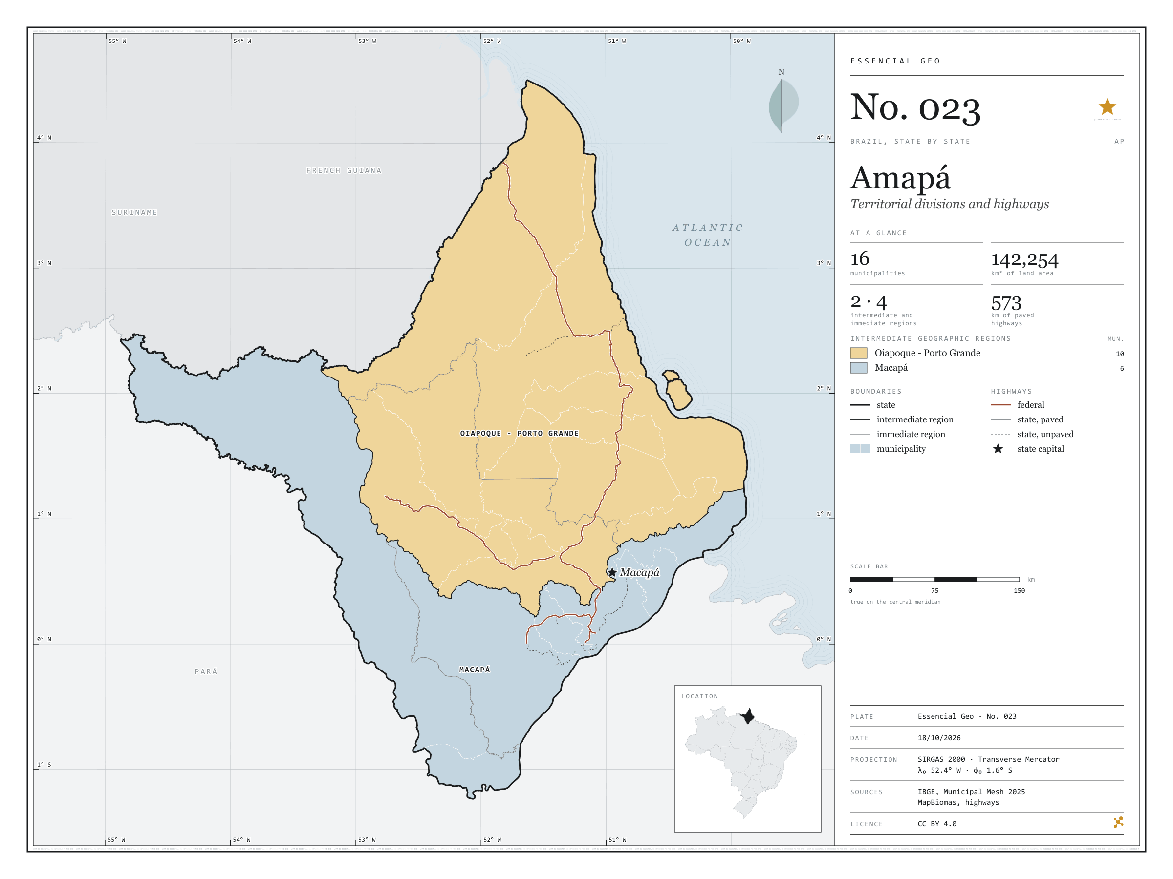
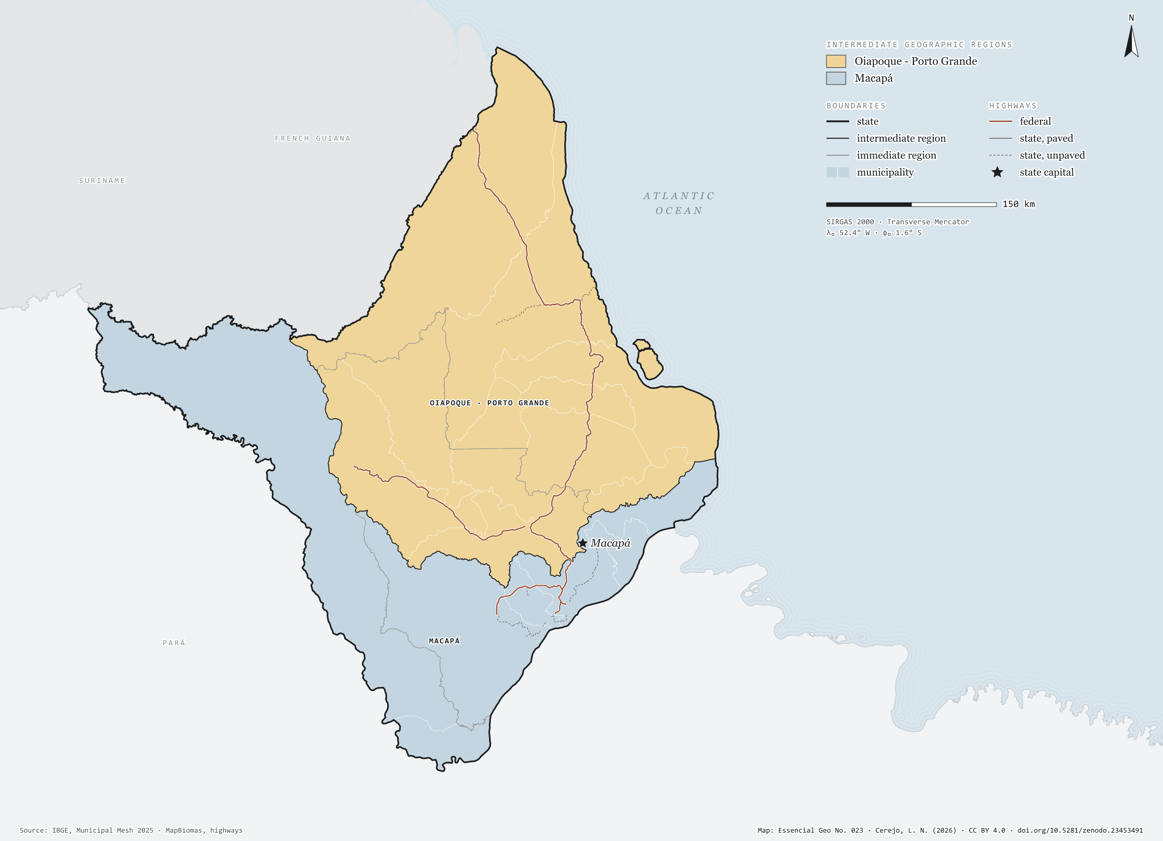
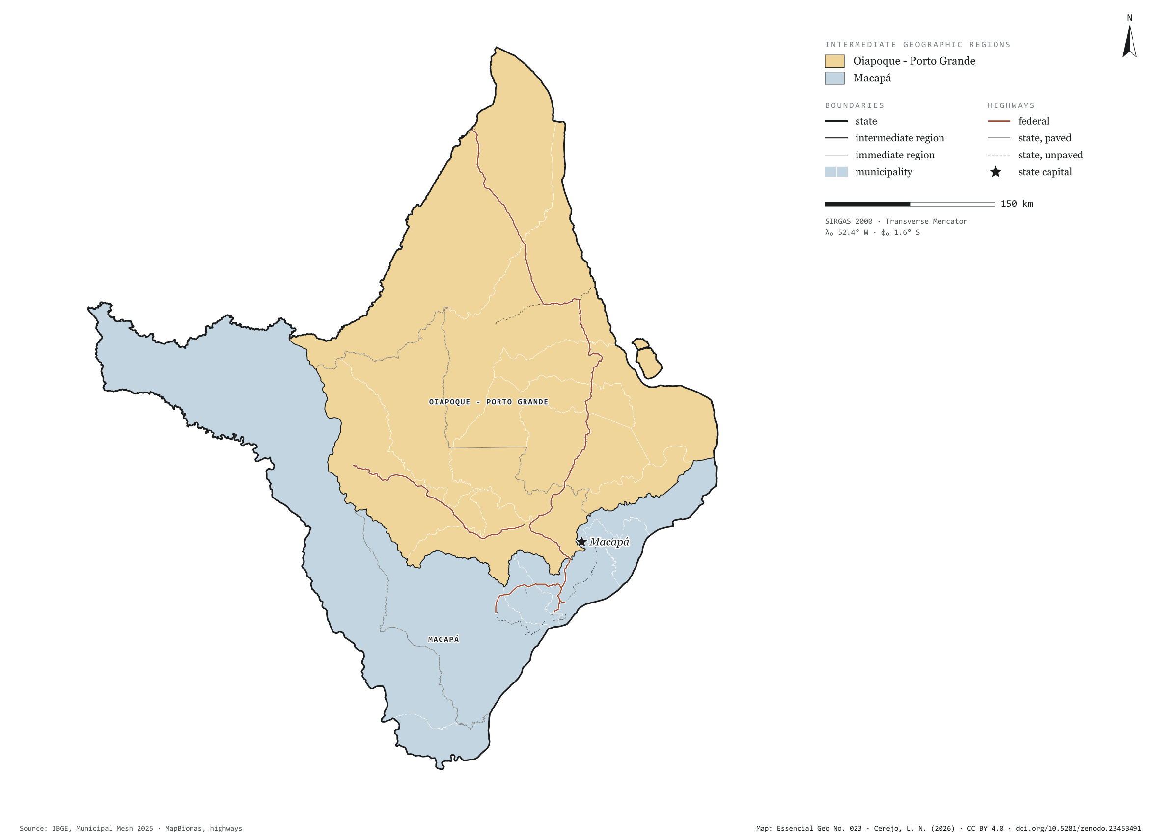
Fig. 023Amapá state (AP)EPSG:4674Source: IBGE, MapBiomas, Natural Earth
Amapá has 16 municipalities across 142,000 km², 1.7 per cent of Brazil. IBGE groups them into 4 immediate regions, drawn around the towns that supply jobs, trade and services to their surroundings, and into 2 intermediate regions that tie those networks together. Oiapoque - Porto Grande is the intermediate region with the most municipalities (10); Macapá, the one with the fewest (6). The largest municipality is Laranjal do Jari (30,542 km²); the smallest, Santana (1,541 km²). Part of the series “Brazil, state by state”: a clean base, with official boundaries and the road network, to start a map without losing the first afternoon gathering files.
Technical record · downloads · citation
At a glance
Municipalities per intermediate region (municipalities)
Oiapoque - Porto Grande10
Macapá6
Area
142,254km²
Largest municipality: Laranjal do Jari (30,542 km²); smallest: Santana (1,541 km²)
Paved highways
573km
863 km federal and 310 km state highways, paved or not
Layers
municipiospolygon16 municipalities, with IBGE code, regions, urban concentration and area (km²)
regioes_intermediariaspolygon2 intermediate geographic regions
regioes_imediataspolygon4 immediate geographic regions
limite_estadualpolygonBoundary of the federative unit
rodoviaslineFederal and state highways: route number, surface, physical status, carriageways
capitalpointIndicative point for the capital (not the exact seat)
The map without a frame, with legend, scale, reference system and credit written on it: ready for papers, lectures and slides. In two versions: with the basemap (neighbours and sea) or only the mapped area, on white.
CEREJO, Lucas Nakamura. Amapá: divisão territorial e rodovias. Versão 1.0.0. [S. l.]: Zenodo, 2026. Conjunto de dados. DOI: 10.5281/zenodo.23453491. Disponível em: https://doi.org/10.5281/zenodo.23453491. Acesso em: 10 nov. 2026.
Cerejo, L. N. (2026). Amapá: divisão territorial e rodovias [Amapá: Territorial divisions and highways] (Version 1.0.0) [Data set]. Zenodo. https://doi.org/10.5281/zenodo.23453491
@dataset{cerejo2026_estado_amapa,
  author    = {Cerejo, Lucas Nakamura},
  title     = {Amapá: Divisão territorial e rodovias},
  year      = {2026},
  publisher = {Zenodo},
  version   = {1.0.0},
  doi       = {10.5281/zenodo.23453491},
  url       = {https://doi.org/10.5281/zenodo.23453491},
  language  = {portuguese},
  note      = {English title: Amapá: Territorial divisions and highways. Licence CC BY 4.0}
}
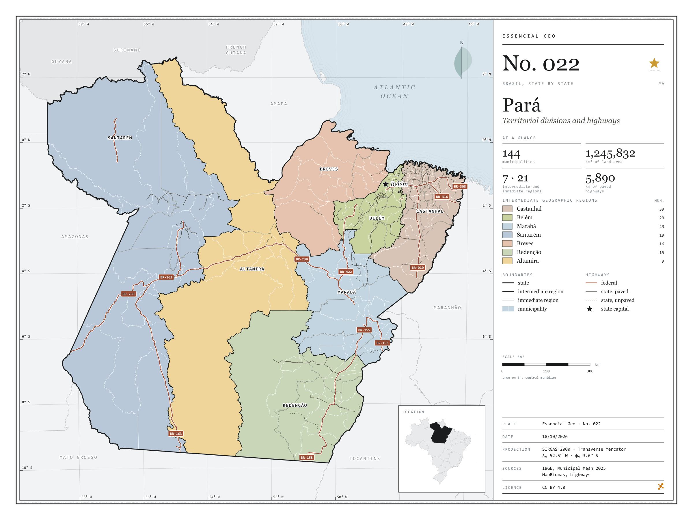
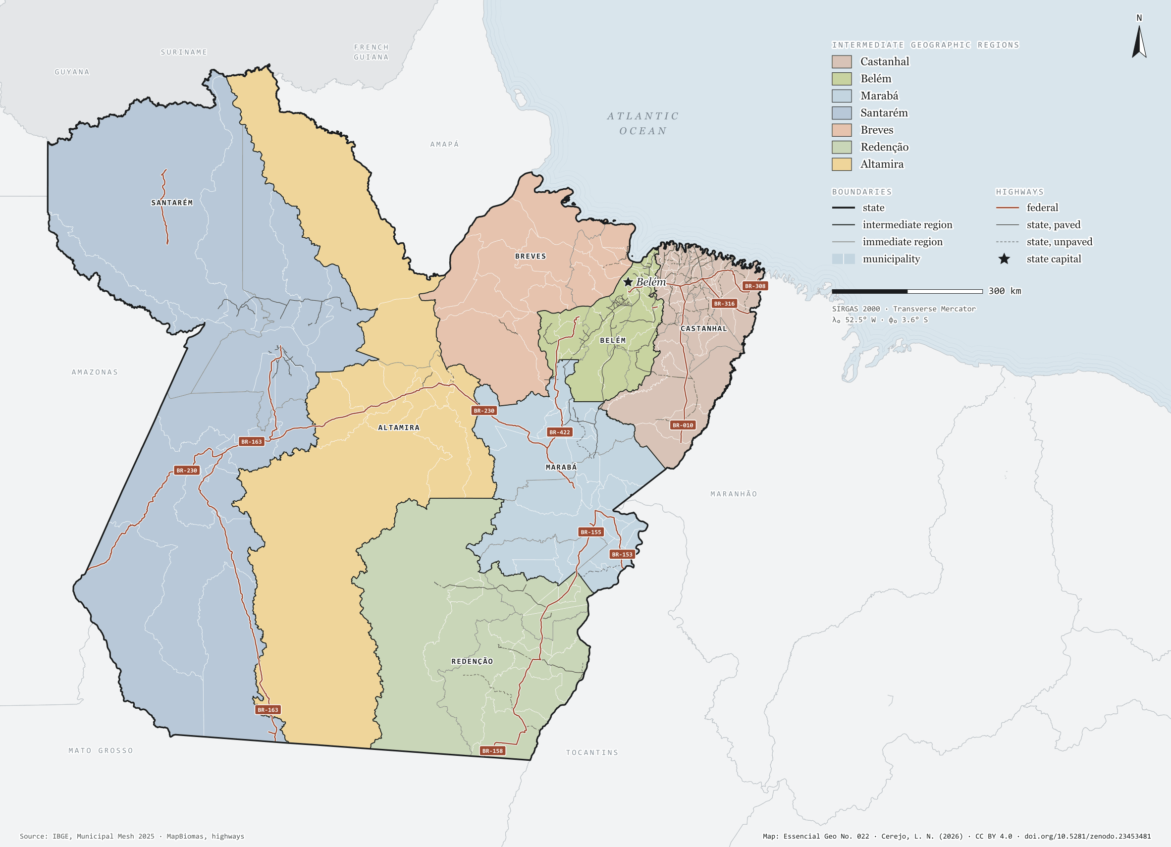
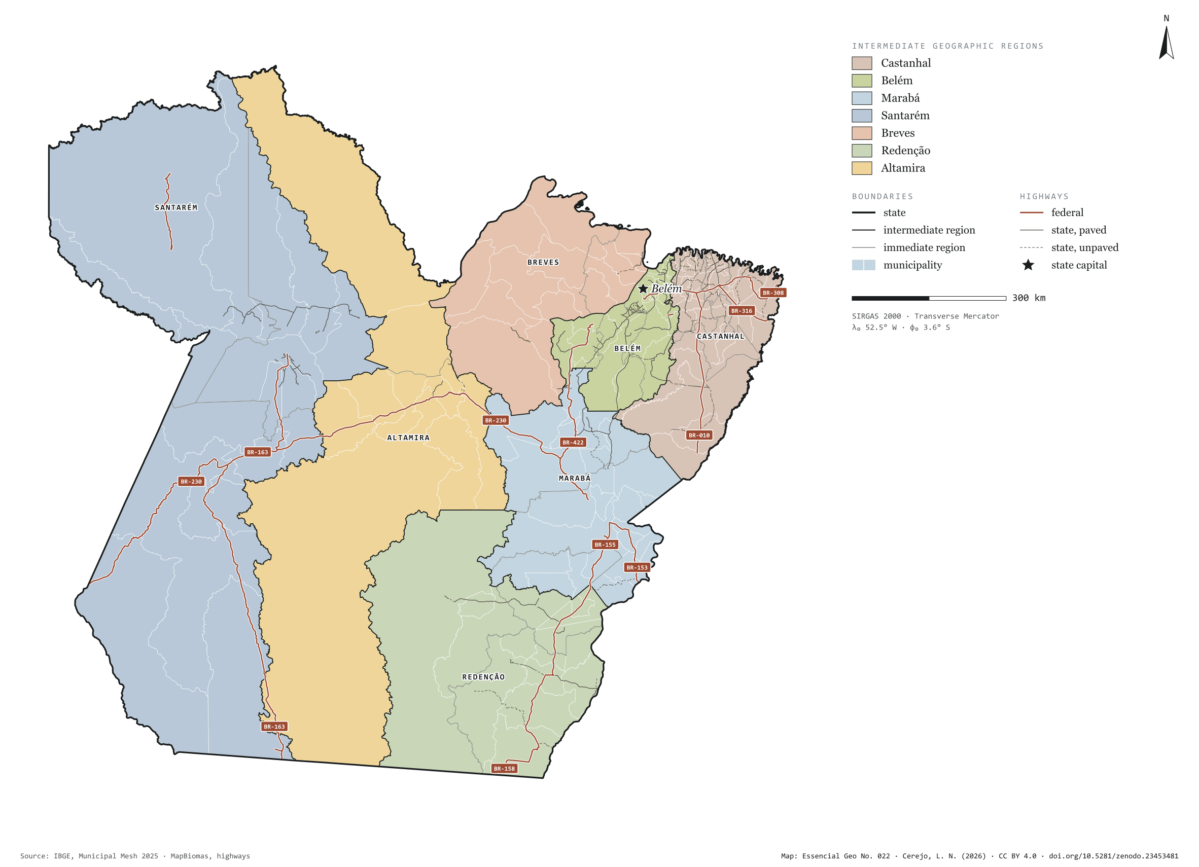
Fig. 022Pará state (PA)EPSG:4674Source: IBGE, MapBiomas, Natural Earth
Pará has 144 municipalities across 1,246,000 km², 14.6 per cent of Brazil. IBGE groups them into 21 immediate regions, drawn around the towns that supply jobs, trade and services to their surroundings, and into 7 intermediate regions that tie those networks together. Castanhal is the intermediate region with the most municipalities (39); Altamira, the one with the fewest (9). The largest municipality is Altamira (159,533 km²); the smallest, Marituba (103 km²). Part of the series “Brazil, state by state”: a clean base, with official boundaries and the road network, to start a map without losing the first afternoon gathering files.
Technical record · downloads · citation
At a glance
Municipalities per intermediate region (municipalities)
Castanhal39
Belém23
Marabá23
Santarém19
Breves16
Redenção15
Altamira9
Area
1,245,832km²
Largest municipality: Altamira (159,533 km²); smallest: Marituba (103 km²)
Paved highways
5,890km
4,361 km federal and 5,202 km state highways, paved or not
Layers
municipiospolygon144 municipalities, with IBGE code, regions, urban concentration and area (km²)
regioes_intermediariaspolygon7 intermediate geographic regions
regioes_imediataspolygon21 immediate geographic regions
limite_estadualpolygonBoundary of the federative unit
rodoviaslineFederal and state highways: route number, surface, physical status, carriageways
capitalpointIndicative point for the capital (not the exact seat)
The map without a frame, with legend, scale, reference system and credit written on it: ready for papers, lectures and slides. In two versions: with the basemap (neighbours and sea) or only the mapped area, on white.
CEREJO, Lucas Nakamura. Pará: divisão territorial e rodovias. Versão 1.0.0. [S. l.]: Zenodo, 2026. Conjunto de dados. DOI: 10.5281/zenodo.23453481. Disponível em: https://doi.org/10.5281/zenodo.23453481. Acesso em: 10 nov. 2026.
Cerejo, L. N. (2026). Pará: divisão territorial e rodovias [Pará: Territorial divisions and highways] (Version 1.0.0) [Data set]. Zenodo. https://doi.org/10.5281/zenodo.23453481
@dataset{cerejo2026_estado_para,
  author    = {Cerejo, Lucas Nakamura},
  title     = {Pará: Divisão territorial e rodovias},
  year      = {2026},
  publisher = {Zenodo},
  version   = {1.0.0},
  doi       = {10.5281/zenodo.23453481},
  url       = {https://doi.org/10.5281/zenodo.23453481},
  language  = {portuguese},
  note      = {English title: Pará: Territorial divisions and highways. Licence CC BY 4.0}
}
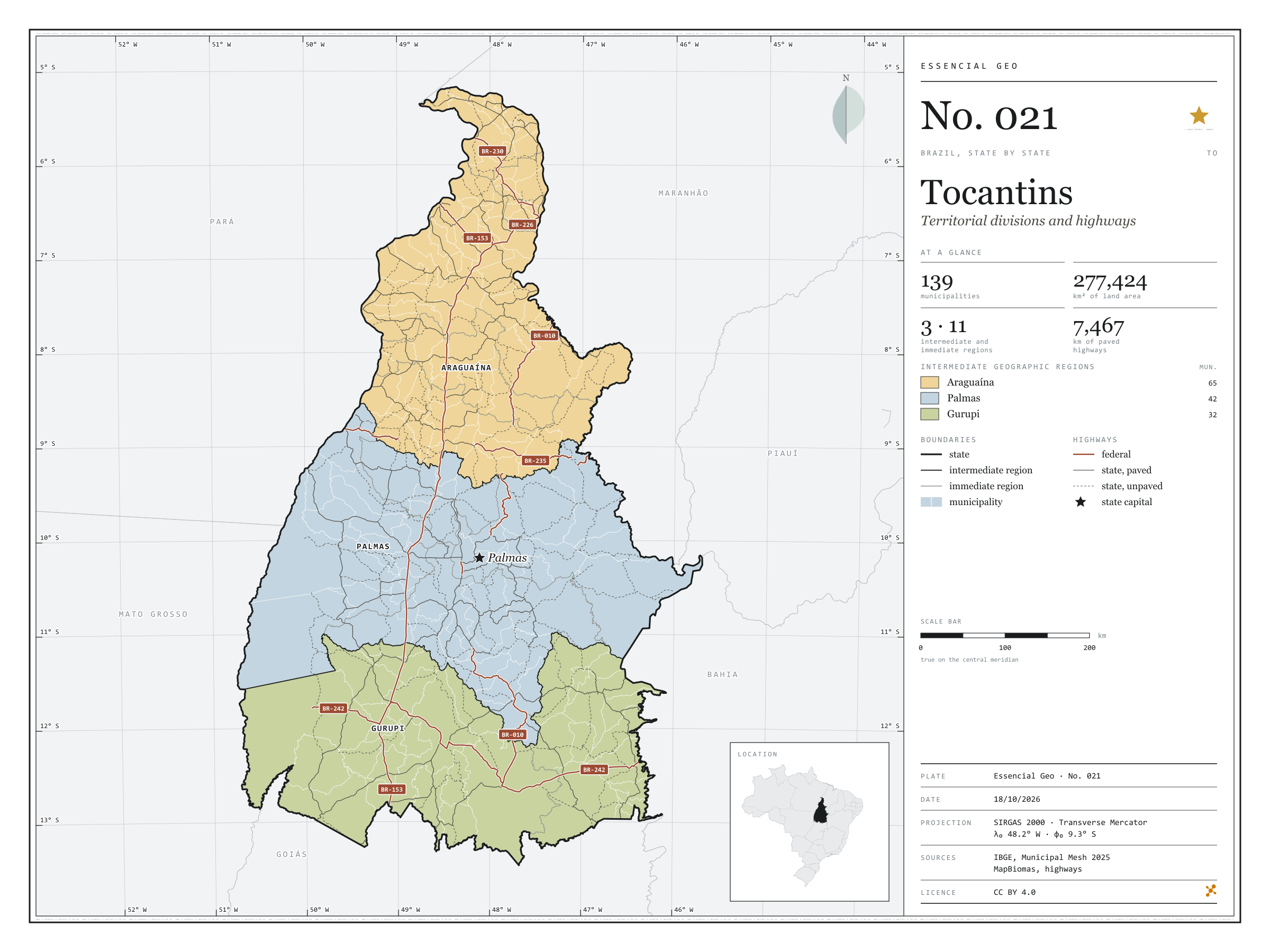
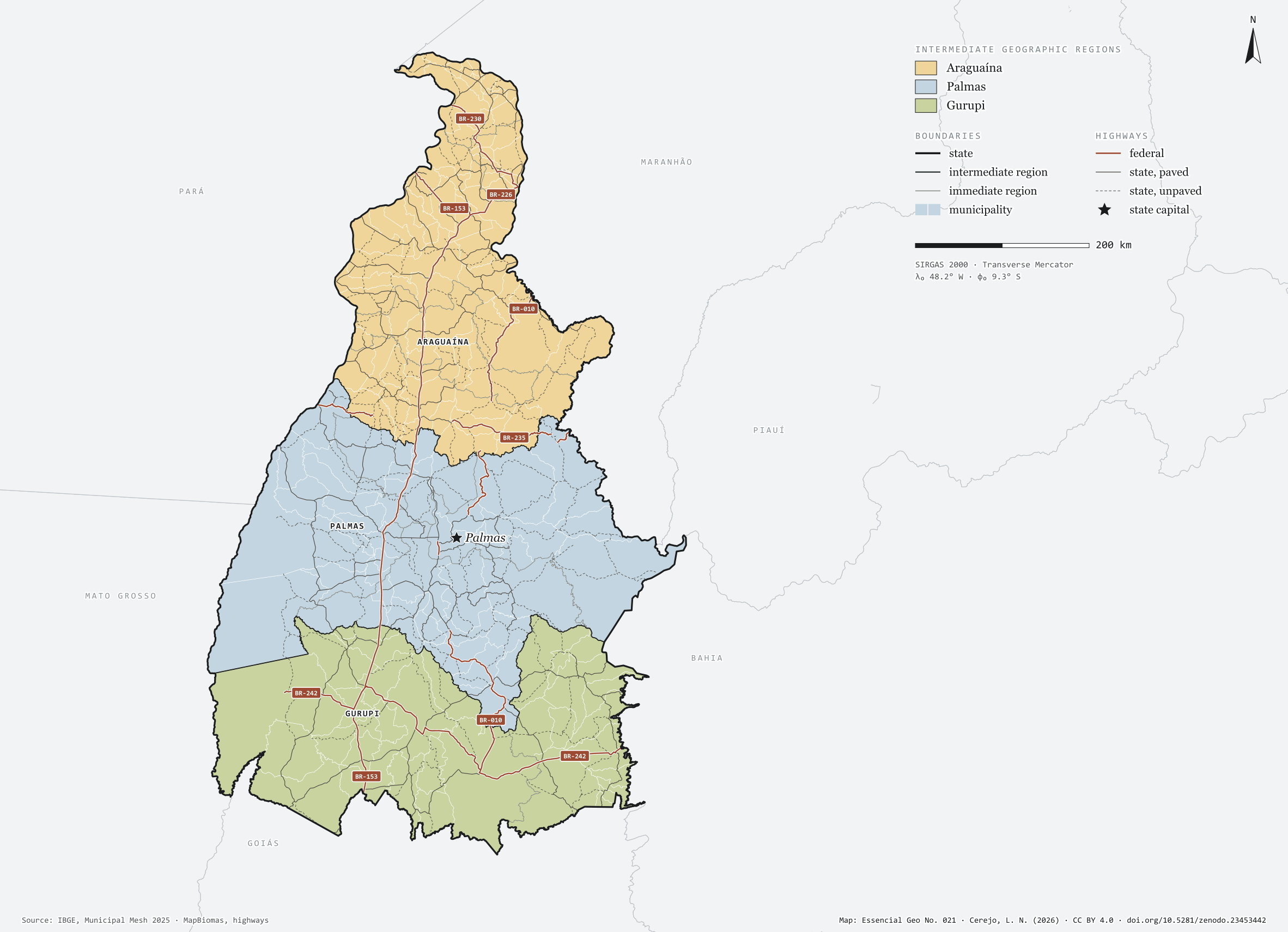
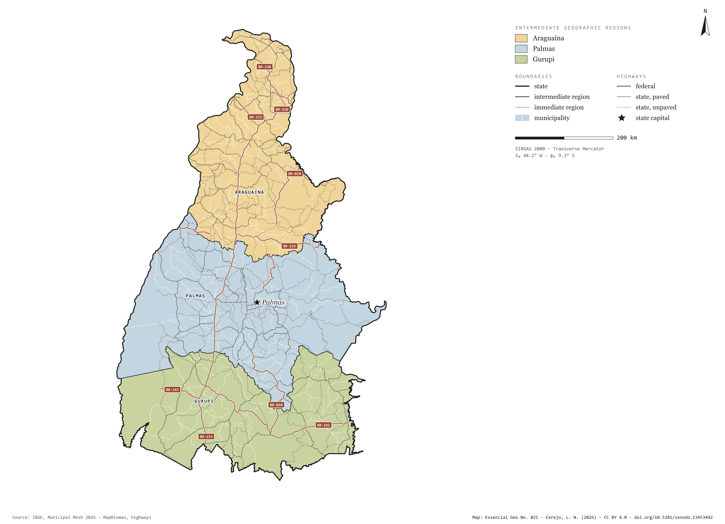
Fig. 021Tocantins state (TO)EPSG:4674Source: IBGE, MapBiomas, Natural Earth
Tocantins has 139 municipalities across 277,000 km², 3.3 per cent of Brazil. IBGE groups them into 11 immediate regions, drawn around the towns that supply jobs, trade and services to their surroundings, and into 3 intermediate regions that tie those networks together. Araguaína is the intermediate region with the most municipalities (65); Gurupi, the one with the fewest (32). The largest municipality is Formoso do Araguaia (13,432 km²); the smallest, Axixá do Tocantins (154 km²). Part of the series “Brazil, state by state”: a clean base, with official boundaries and the road network, to start a map without losing the first afternoon gathering files.
Technical record · downloads · citation
At a glance
Municipalities per intermediate region (municipalities)
Araguaína65
Palmas42
Gurupi32
Area
277,424km²
Largest municipality: Formoso do Araguaia (13,432 km²); smallest: Axixá do Tocantins (154 km²)
Paved highways
7,467km
2,244 km federal and 12,682 km state highways, paved or not
Layers
municipiospolygon139 municipalities, with IBGE code, regions, urban concentration and area (km²)
regioes_intermediariaspolygon3 intermediate geographic regions
regioes_imediataspolygon11 immediate geographic regions
limite_estadualpolygonBoundary of the federative unit
rodoviaslineFederal and state highways: route number, surface, physical status, carriageways
capitalpointIndicative point for the capital (not the exact seat)
The map without a frame, with legend, scale, reference system and credit written on it: ready for papers, lectures and slides. In two versions: with the basemap (neighbours and sea) or only the mapped area, on white.
CEREJO, Lucas Nakamura. Tocantins: divisão territorial e rodovias. Versão 1.0.0. [S. l.]: Zenodo, 2026. Conjunto de dados. DOI: 10.5281/zenodo.23453442. Disponível em: https://doi.org/10.5281/zenodo.23453442. Acesso em: 10 nov. 2026.
Cerejo, L. N. (2026). Tocantins: divisão territorial e rodovias [Tocantins: Territorial divisions and highways] (Version 1.0.0) [Data set]. Zenodo. https://doi.org/10.5281/zenodo.23453442
@dataset{cerejo2026_estado_tocantins,
  author    = {Cerejo, Lucas Nakamura},
  title     = {Tocantins: Divisão territorial e rodovias},
  year      = {2026},
  publisher = {Zenodo},
  version   = {1.0.0},
  doi       = {10.5281/zenodo.23453442},
  url       = {https://doi.org/10.5281/zenodo.23453442},
  language  = {portuguese},
  note      = {English title: Tocantins: Territorial divisions and highways. Licence CC BY 4.0}
}
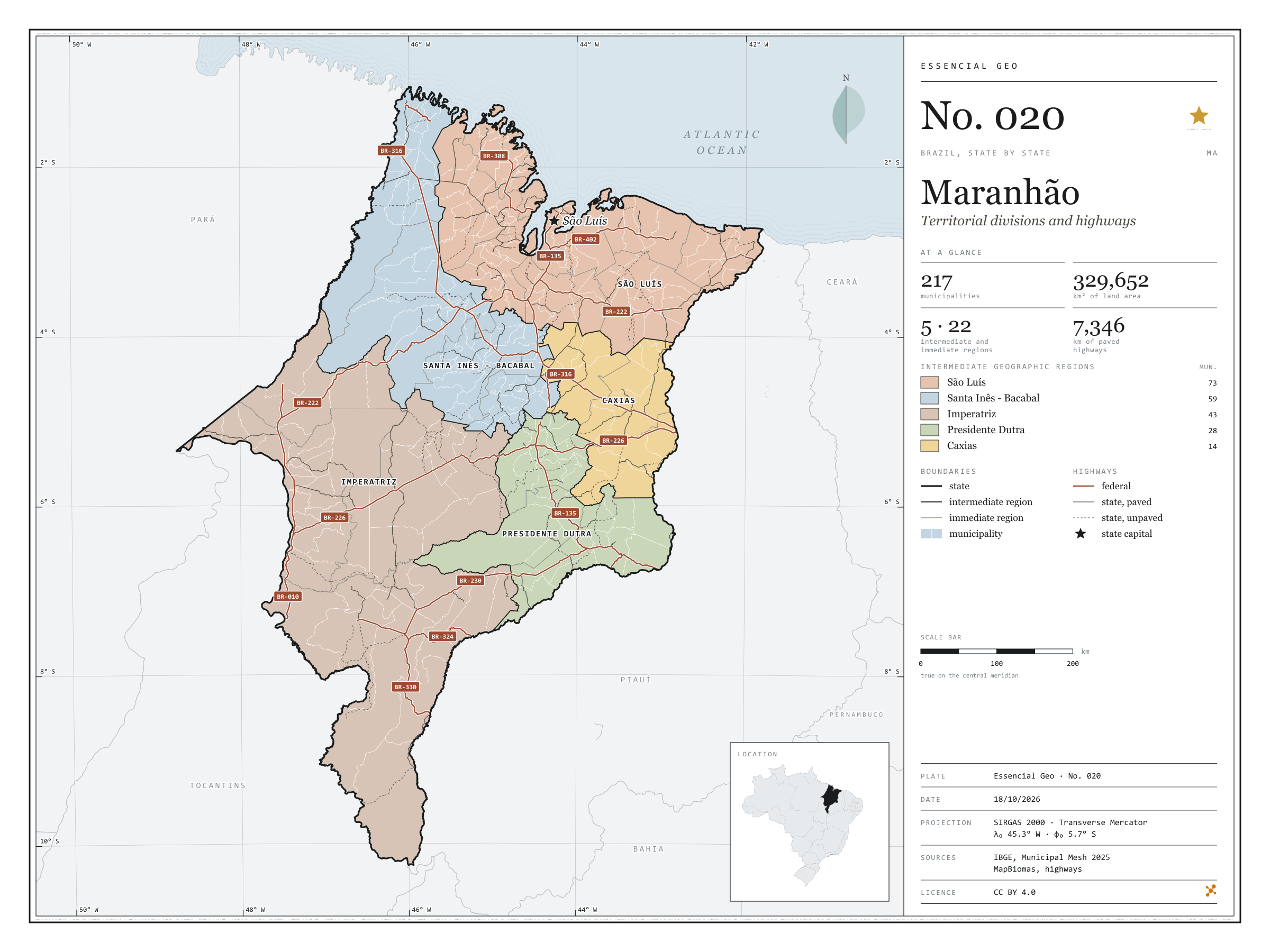
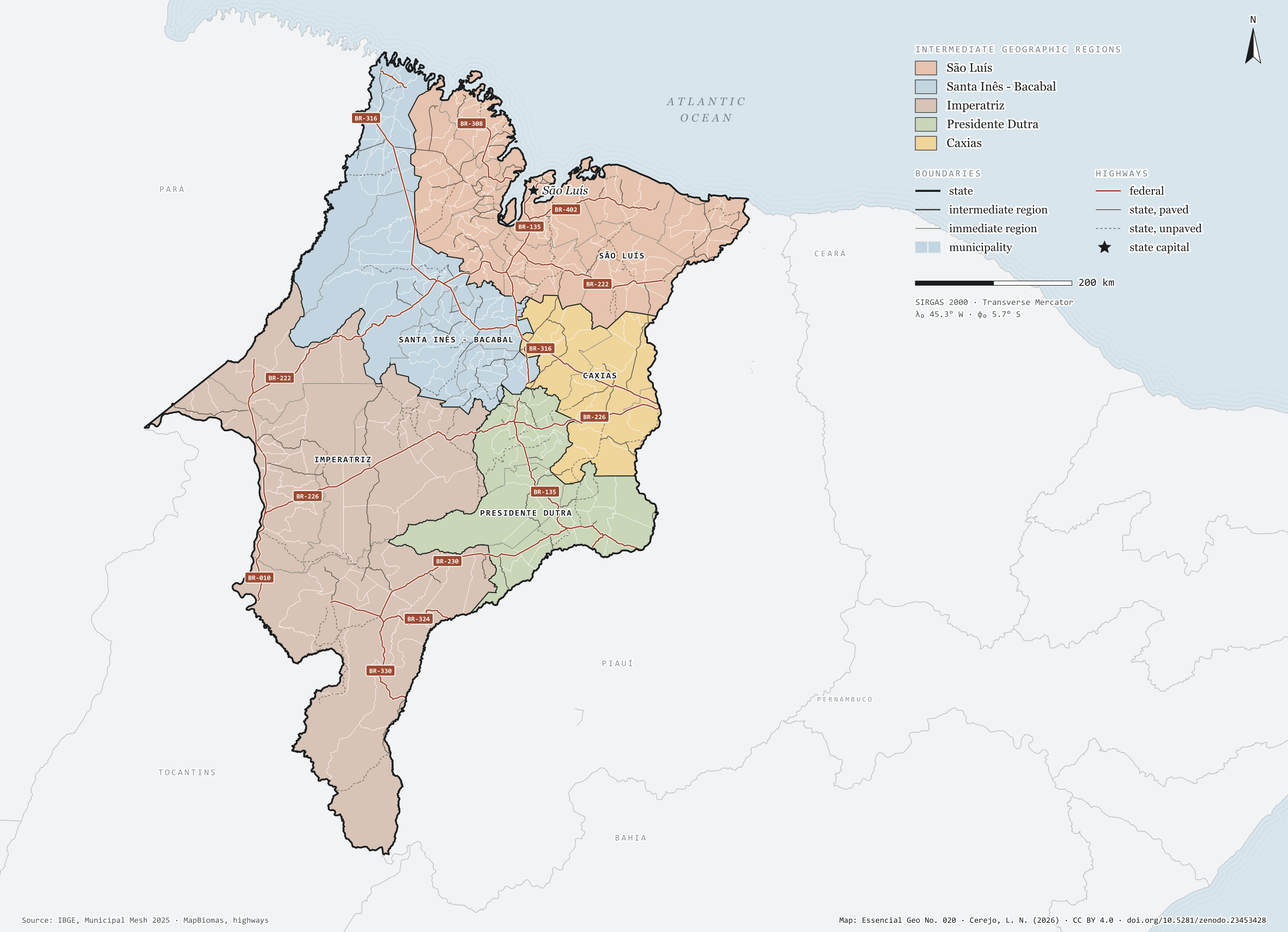
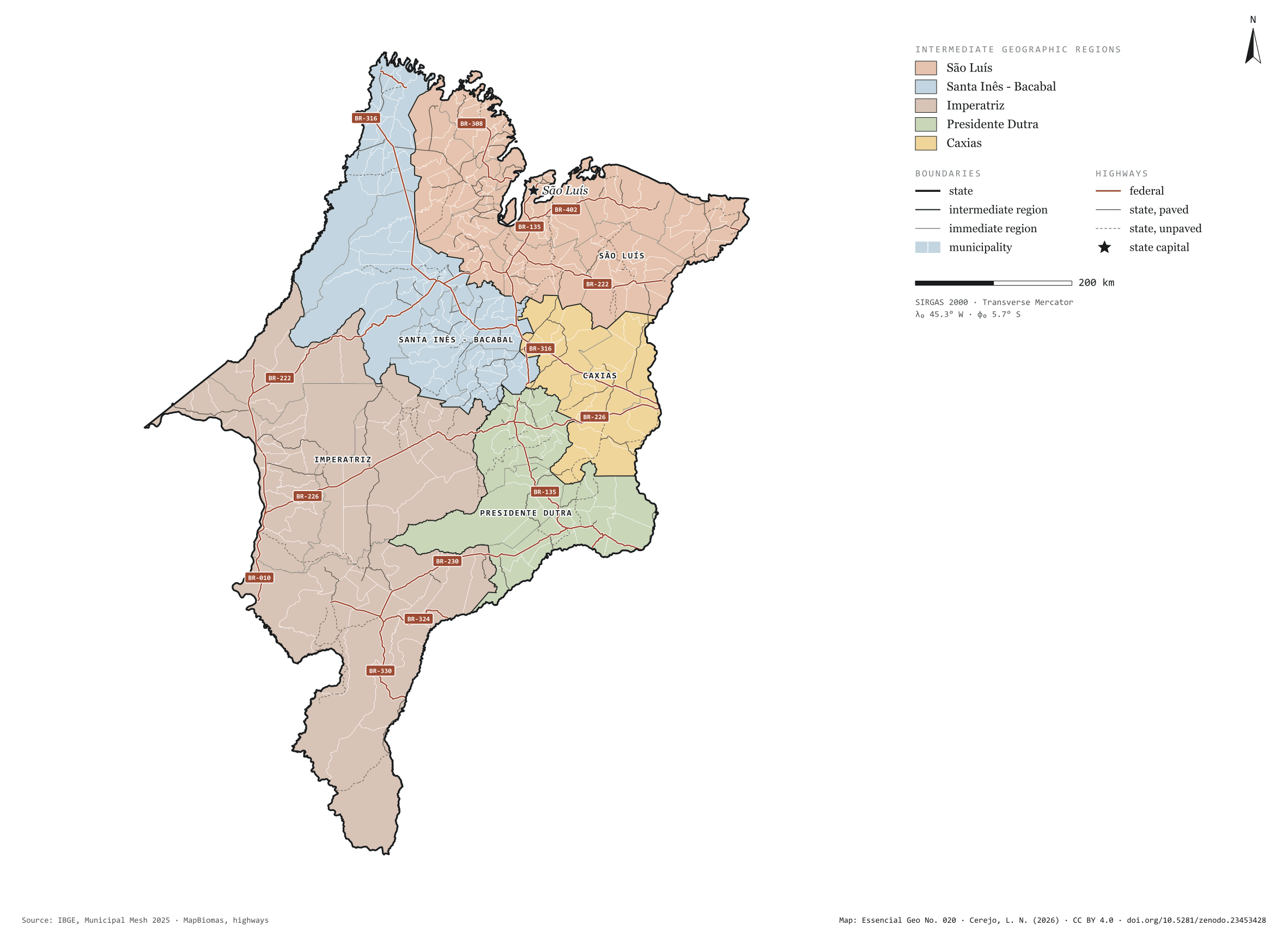
Fig. 020Maranhão state (MA)EPSG:4674Source: IBGE, MapBiomas, Natural Earth
Maranhão has 217 municipalities across 330,000 km², 3.9 per cent of Brazil. IBGE groups them into 22 immediate regions, drawn around the towns that supply jobs, trade and services to their surroundings, and into 5 intermediate regions that tie those networks together. São Luís is the intermediate region with the most municipalities (73); Caxias, the one with the fewest (14). The largest municipality is Balsas (12,602 km²); the smallest, Raposa (79 km²). Part of the series “Brazil, state by state”: a clean base, with official boundaries and the road network, to start a map without losing the first afternoon gathering files.
Technical record · downloads · citation
At a glance
Municipalities per intermediate region (municipalities)
São Luís73
Santa Inês - Bacabal59
Imperatriz43
Presidente Dutra28
Caxias14
Area
329,652km²
Largest municipality: Balsas (12,602 km²); smallest: Raposa (79 km²)
Paved highways
7,346km
3,745 km federal and 6,767 km state highways, paved or not
Layers
municipiospolygon217 municipalities, with IBGE code, regions, urban concentration and area (km²)
regioes_intermediariaspolygon5 intermediate geographic regions
regioes_imediataspolygon22 immediate geographic regions
limite_estadualpolygonBoundary of the federative unit
rodoviaslineFederal and state highways: route number, surface, physical status, carriageways
capitalpointIndicative point for the capital (not the exact seat)
The map without a frame, with legend, scale, reference system and credit written on it: ready for papers, lectures and slides. In two versions: with the basemap (neighbours and sea) or only the mapped area, on white.
CEREJO, Lucas Nakamura. Maranhão: divisão territorial e rodovias. Versão 1.0.0. [S. l.]: Zenodo, 2026. Conjunto de dados. DOI: 10.5281/zenodo.23453428. Disponível em: https://doi.org/10.5281/zenodo.23453428. Acesso em: 10 nov. 2026.
Cerejo, L. N. (2026). Maranhão: divisão territorial e rodovias [Maranhão: Territorial divisions and highways] (Version 1.0.0) [Data set]. Zenodo. https://doi.org/10.5281/zenodo.23453428
@dataset{cerejo2026_estado_maranhao,
  author    = {Cerejo, Lucas Nakamura},
  title     = {Maranhão: Divisão territorial e rodovias},
  year      = {2026},
  publisher = {Zenodo},
  version   = {1.0.0},
  doi       = {10.5281/zenodo.23453428},
  url       = {https://doi.org/10.5281/zenodo.23453428},
  language  = {portuguese},
  note      = {English title: Maranhão: Territorial divisions and highways. Licence CC BY 4.0}
}
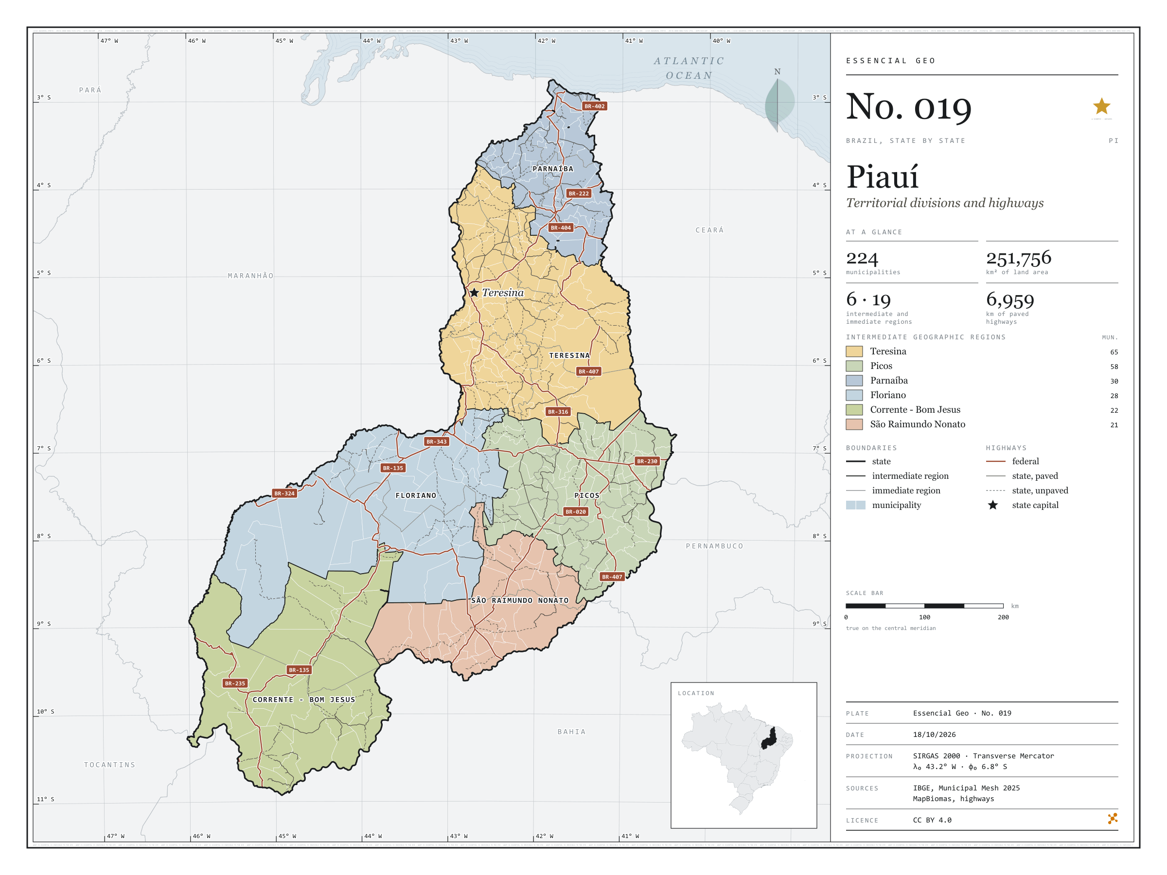
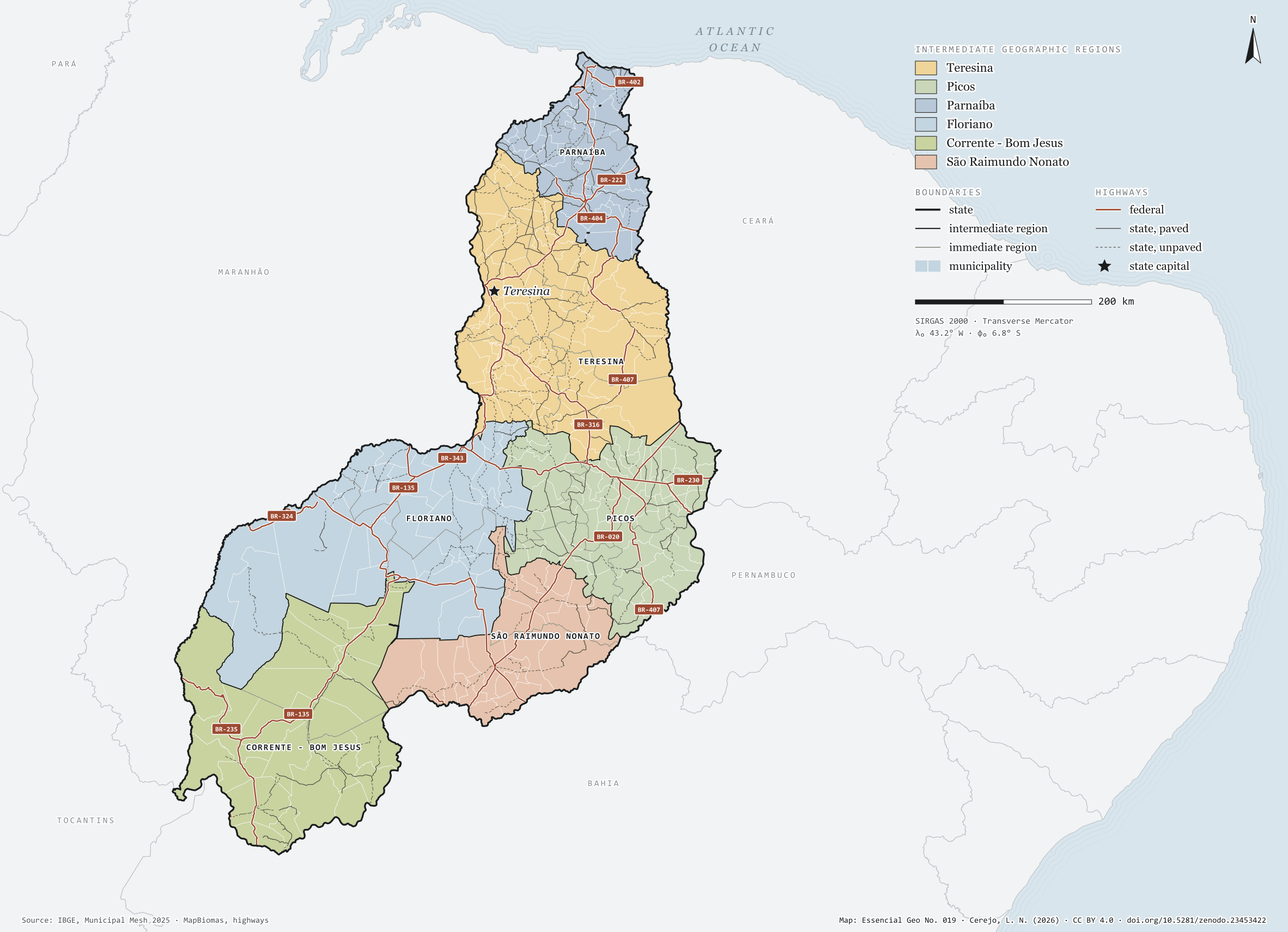
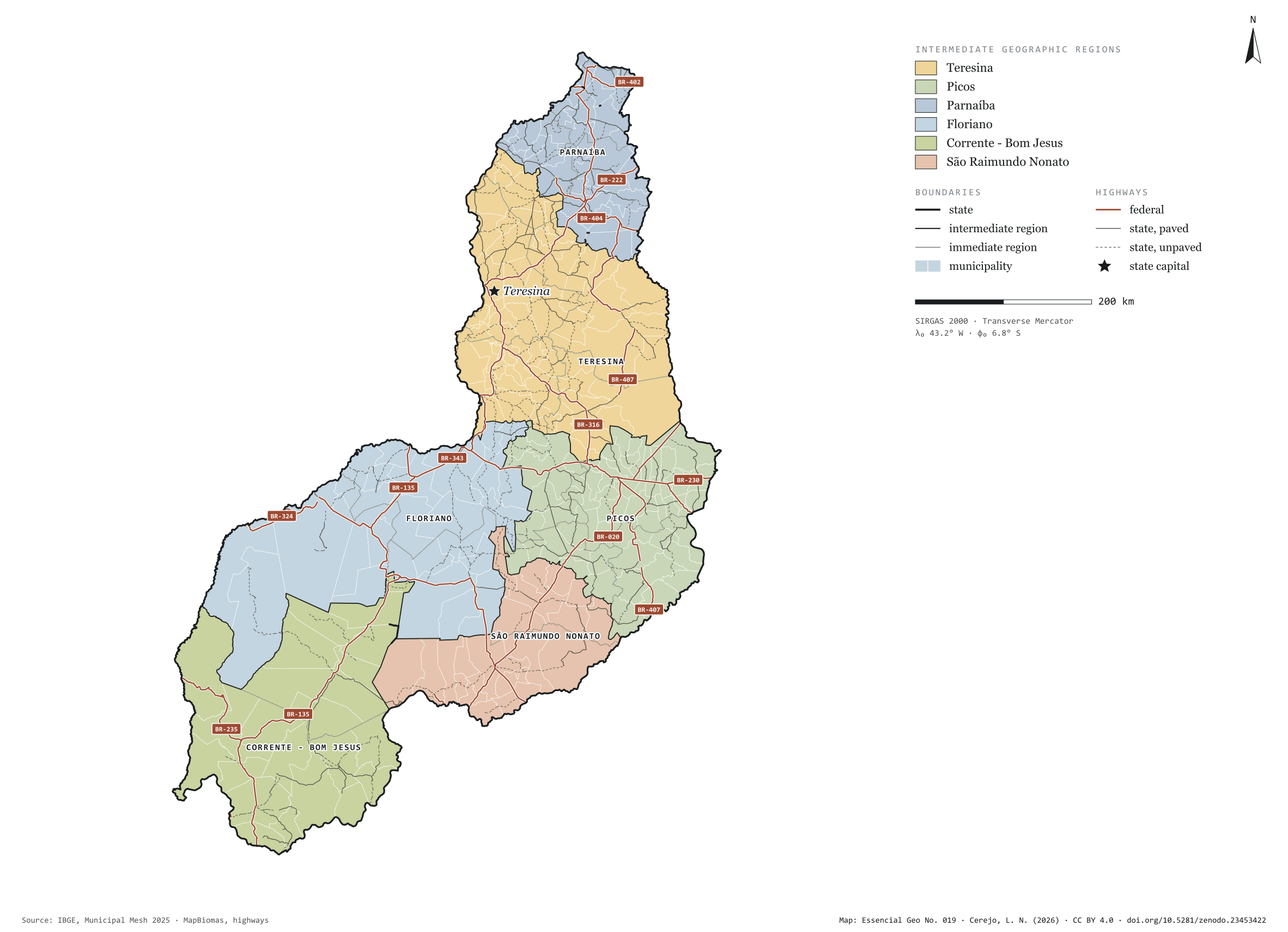
Fig. 019Piauí state (PI)EPSG:4674Source: IBGE, MapBiomas, Natural Earth
Piauí has 224 municipalities across 252,000 km², 3.0 per cent of Brazil. IBGE groups them into 19 immediate regions, drawn around the towns that supply jobs, trade and services to their surroundings, and into 6 intermediate regions that tie those networks together. Teresina is the intermediate region with the most municipalities (65); São Raimundo Nonato, the one with the fewest (21). The largest municipality is Uruçuí (8,413 km²); the smallest, Santo Antônio dos Milagres (34 km²). Part of the series “Brazil, state by state”: a clean base, with official boundaries and the road network, to start a map without losing the first afternoon gathering files.
Technical record · downloads · citation
At a glance
Municipalities per intermediate region (municipalities)
Teresina65
Picos58
Parnaíba30
Floriano28
Corrente - Bom Jesus22
São Raimundo Nonato21
Area
251,756km²
Largest municipality: Uruçuí (8,413 km²); smallest: Santo Antônio dos Milagres (34 km²)
Paved highways
6,959km
3,564 km federal and 8,626 km state highways, paved or not
Layers
municipiospolygon224 municipalities, with IBGE code, regions, urban concentration and area (km²)
regioes_intermediariaspolygon6 intermediate geographic regions
regioes_imediataspolygon19 immediate geographic regions
limite_estadualpolygonBoundary of the federative unit
rodoviaslineFederal and state highways: route number, surface, physical status, carriageways
capitalpointIndicative point for the capital (not the exact seat)
The map without a frame, with legend, scale, reference system and credit written on it: ready for papers, lectures and slides. In two versions: with the basemap (neighbours and sea) or only the mapped area, on white.
CEREJO, Lucas Nakamura. Piauí: divisão territorial e rodovias. Versão 1.0.0. [S. l.]: Zenodo, 2026. Conjunto de dados. DOI: 10.5281/zenodo.23453422. Disponível em: https://doi.org/10.5281/zenodo.23453422. Acesso em: 10 nov. 2026.
Cerejo, L. N. (2026). Piauí: divisão territorial e rodovias [Piauí: Territorial divisions and highways] (Version 1.0.0) [Data set]. Zenodo. https://doi.org/10.5281/zenodo.23453422
@dataset{cerejo2026_estado_piaui,
  author    = {Cerejo, Lucas Nakamura},
  title     = {Piauí: Divisão territorial e rodovias},
  year      = {2026},
  publisher = {Zenodo},
  version   = {1.0.0},
  doi       = {10.5281/zenodo.23453422},
  url       = {https://doi.org/10.5281/zenodo.23453422},
  language  = {portuguese},
  note      = {English title: Piauí: Territorial divisions and highways. Licence CC BY 4.0}
}
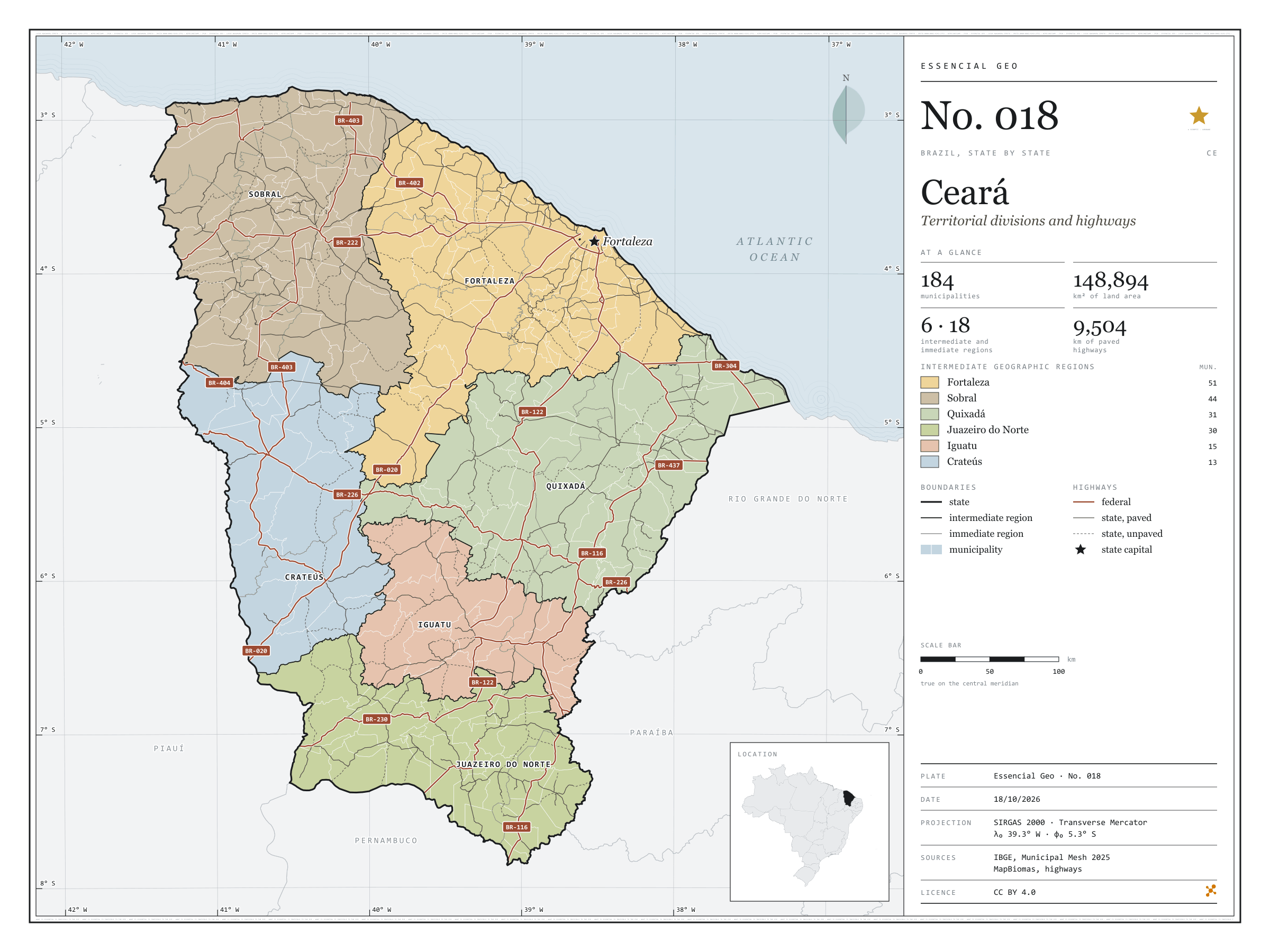
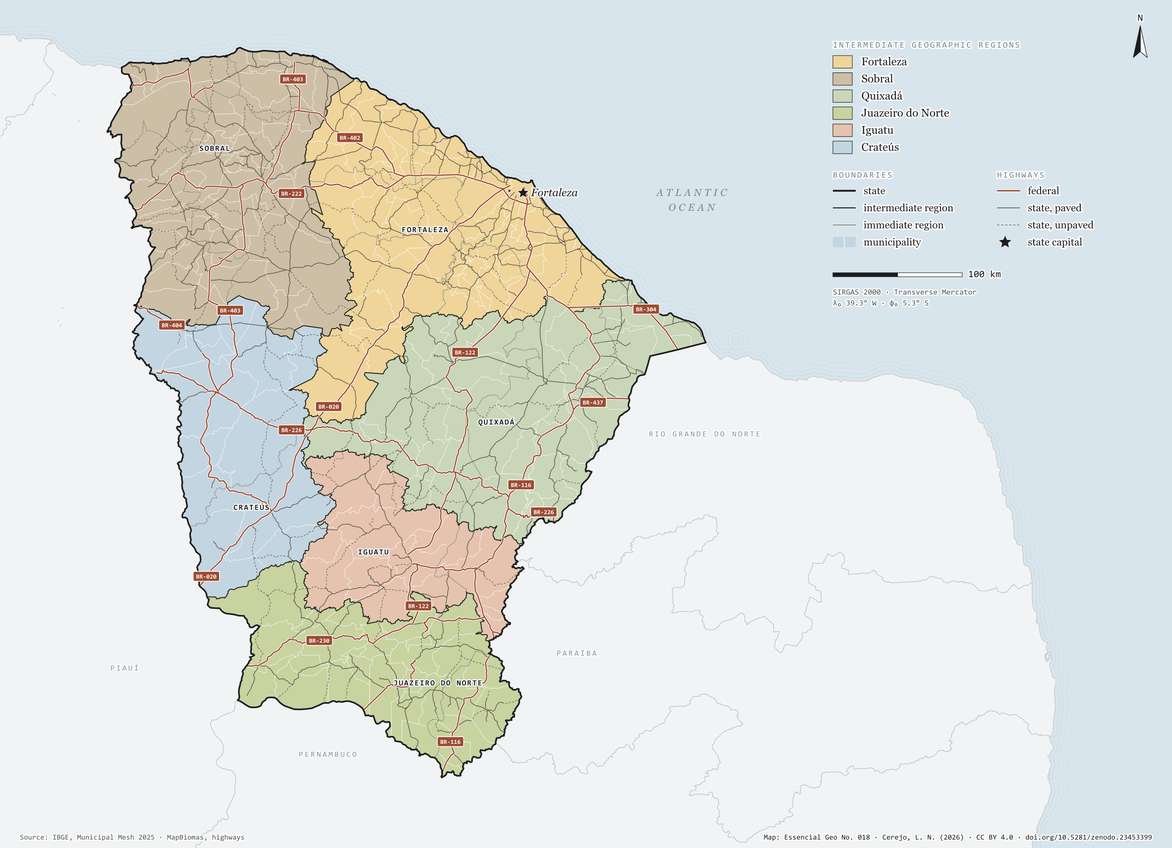
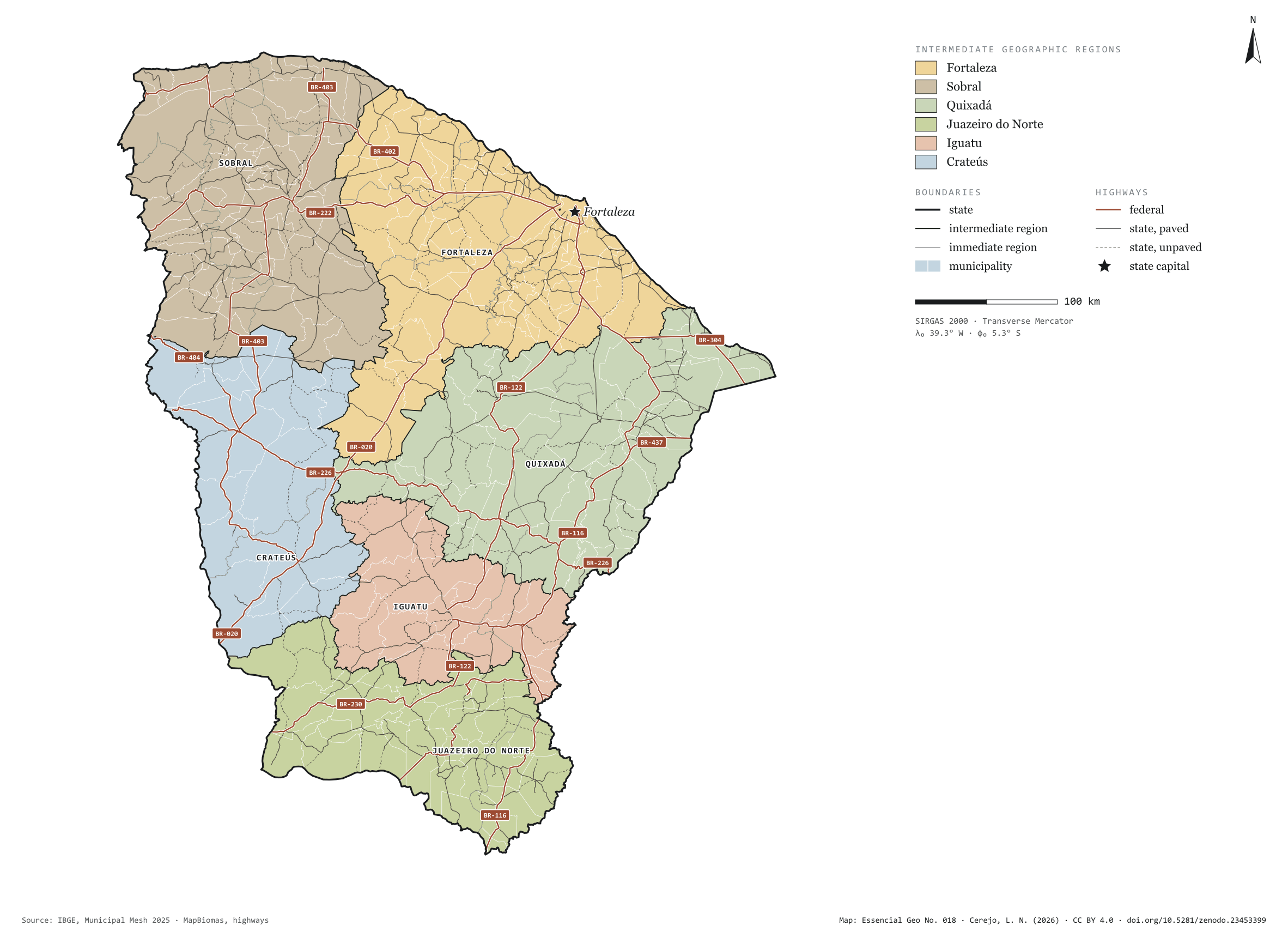
Fig. 018Ceará state (CE)EPSG:4674Source: IBGE, MapBiomas, Natural Earth
Ceará has 184 municipalities across 149,000 km², 1.7 per cent of Brazil. IBGE groups them into 18 immediate regions, drawn around the towns that supply jobs, trade and services to their surroundings, and into 6 intermediate regions that tie those networks together. Fortaleza is the intermediate region with the most municipalities (51); Crateús, the one with the fewest (13). The largest municipality is Santa Quitéria (4,262 km²); the smallest, Altaneira (73 km²). Part of the series “Brazil, state by state”: a clean base, with official boundaries and the road network, to start a map without losing the first afternoon gathering files.
Technical record · downloads · citation
At a glance
Municipalities per intermediate region (municipalities)
Fortaleza51
Sobral44
Quixadá31
Juazeiro do Norte30
Iguatu15
Crateús13
Area
148,894km²
Largest municipality: Santa Quitéria (4,262 km²); smallest: Altaneira (73 km²)
Paved highways
9,504km
3,287 km federal and 9,311 km state highways, paved or not
Layers
municipiospolygon184 municipalities, with IBGE code, regions, urban concentration and area (km²)
regioes_intermediariaspolygon6 intermediate geographic regions
regioes_imediataspolygon18 immediate geographic regions
limite_estadualpolygonBoundary of the federative unit
rodoviaslineFederal and state highways: route number, surface, physical status, carriageways
capitalpointIndicative point for the capital (not the exact seat)
The map without a frame, with legend, scale, reference system and credit written on it: ready for papers, lectures and slides. In two versions: with the basemap (neighbours and sea) or only the mapped area, on white.
CEREJO, Lucas Nakamura. Ceará: divisão territorial e rodovias. Versão 1.0.0. [S. l.]: Zenodo, 2026. Conjunto de dados. DOI: 10.5281/zenodo.23453399. Disponível em: https://doi.org/10.5281/zenodo.23453399. Acesso em: 10 nov. 2026.
Cerejo, L. N. (2026). Ceará: divisão territorial e rodovias [Ceará: Territorial divisions and highways] (Version 1.0.0) [Data set]. Zenodo. https://doi.org/10.5281/zenodo.23453399
@dataset{cerejo2026_estado_ceara,
  author    = {Cerejo, Lucas Nakamura},
  title     = {Ceará: Divisão territorial e rodovias},
  year      = {2026},
  publisher = {Zenodo},
  version   = {1.0.0},
  doi       = {10.5281/zenodo.23453399},
  url       = {https://doi.org/10.5281/zenodo.23453399},
  language  = {portuguese},
  note      = {English title: Ceará: Territorial divisions and highways. Licence CC BY 4.0}
}
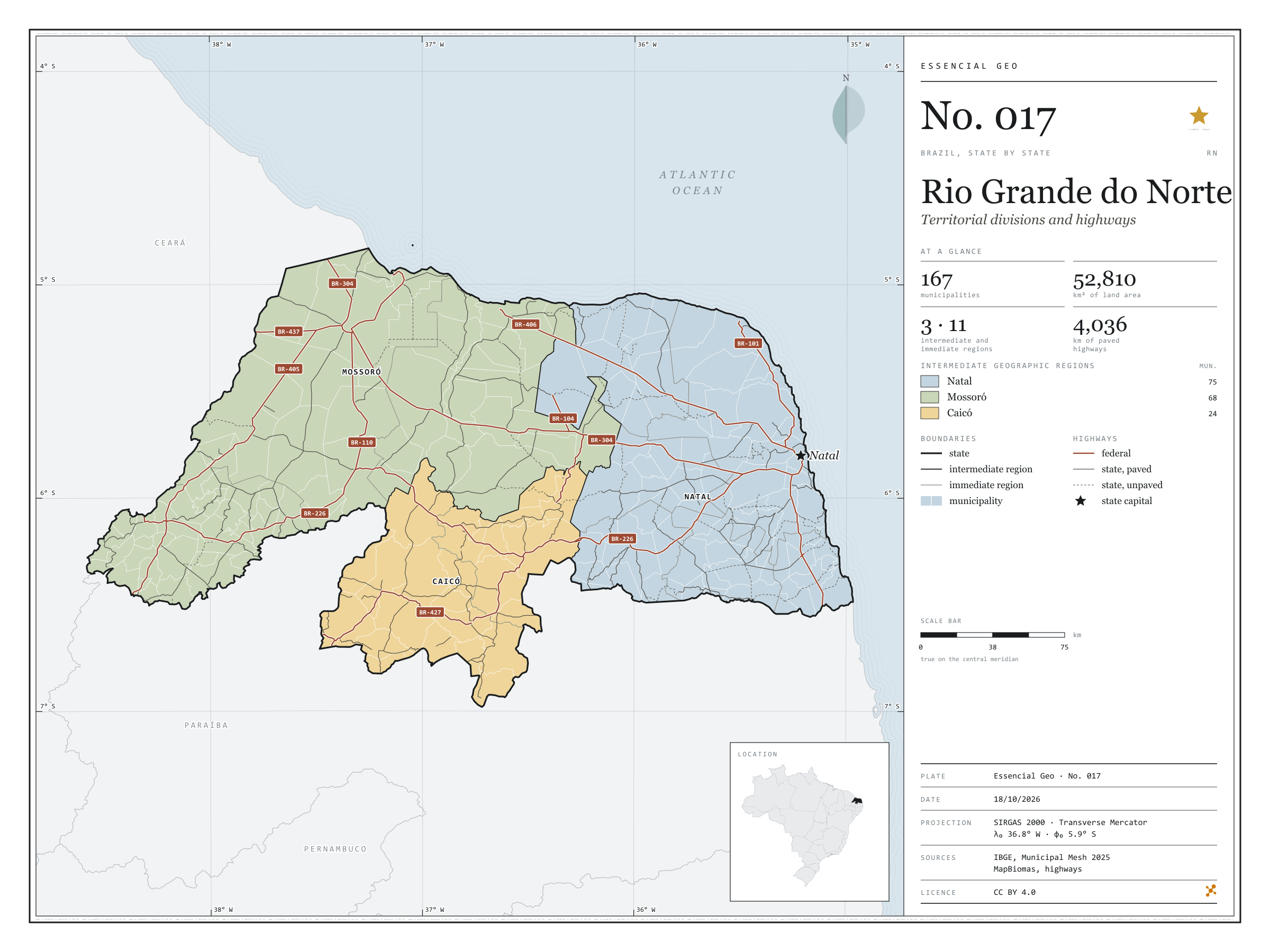
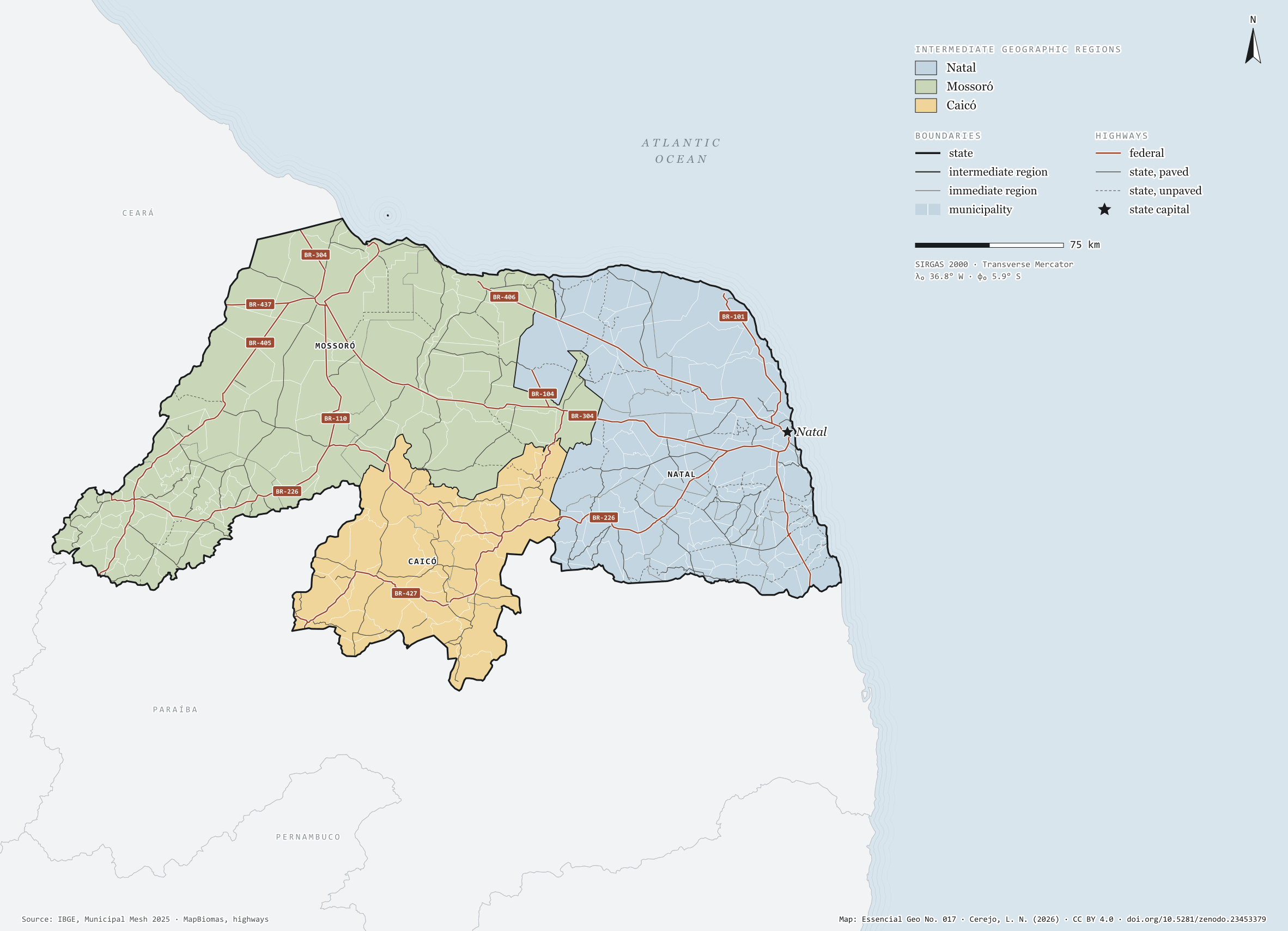
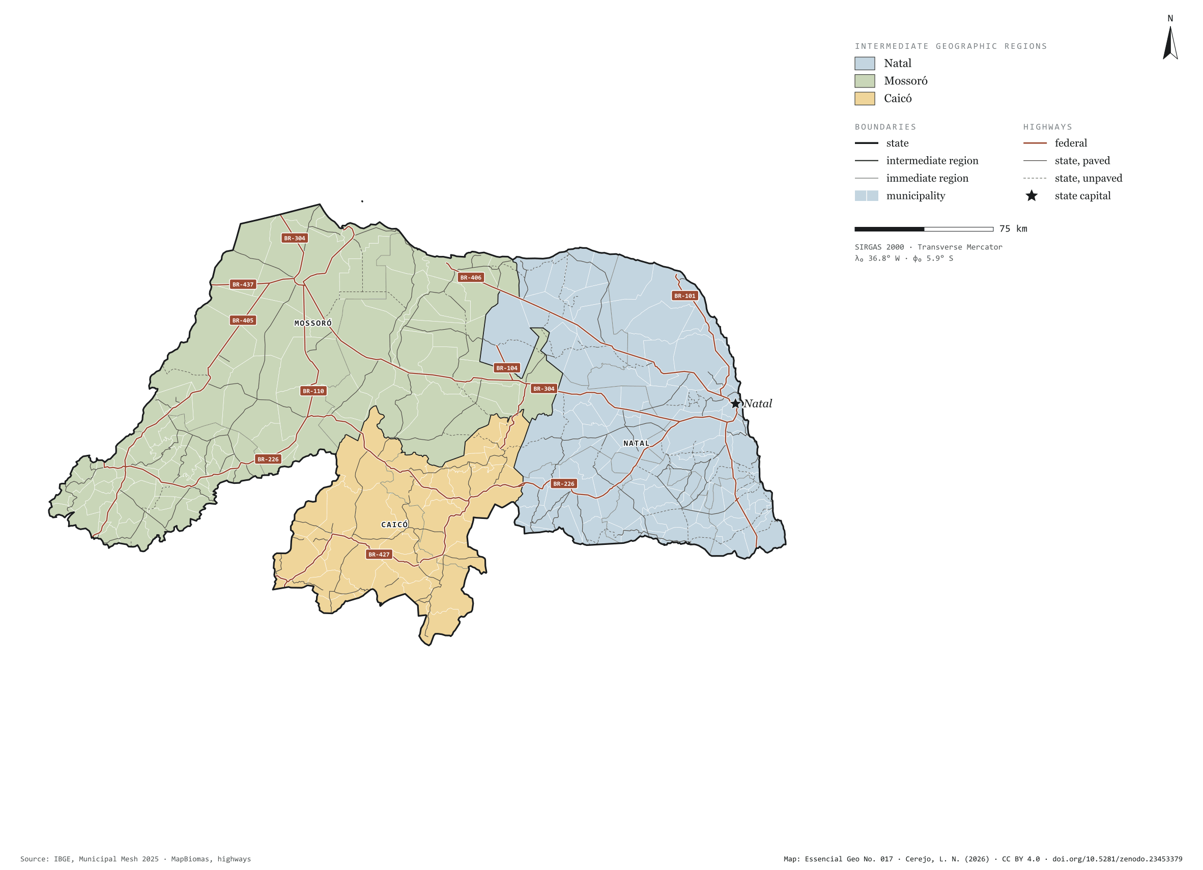
Fig. 017Rio Grande do Norte state (RN)EPSG:4674Source: IBGE, MapBiomas, Natural Earth
Rio Grande do Norte has 167 municipalities across 53,000 km², 0.6 per cent of Brazil. IBGE groups them into 11 immediate regions, drawn around the towns that supply jobs, trade and services to their surroundings, and into 3 intermediate regions that tie those networks together. Natal is the intermediate region with the most municipalities (75); Caicó, the one with the fewest (24). The largest municipality is Mossoró (2,099 km²); the smallest, Senador Georgino Avelino (26 km²). Part of the series “Brazil, state by state”: a clean base, with official boundaries and the road network, to start a map without losing the first afternoon gathering files.
Technical record · downloads · citation
At a glance
Municipalities per intermediate region (municipalities)
The map without a frame, with legend, scale, reference system and credit written on it: ready for papers, lectures and slides. In two versions: with the basemap (neighbours and sea) or only the mapped area, on white.
CEREJO, Lucas Nakamura. Rio Grande do Norte: divisão territorial e rodovias. Versão 1.0.0. [S. l.]: Zenodo, 2026. Conjunto de dados. DOI: 10.5281/zenodo.23453379. Disponível em: https://doi.org/10.5281/zenodo.23453379. Acesso em: 10 nov. 2026.
Cerejo, L. N. (2026). Rio Grande do Norte: divisão territorial e rodovias [Rio Grande do Norte: Territorial divisions and highways] (Version 1.0.0) [Data set]. Zenodo. https://doi.org/10.5281/zenodo.23453379
@dataset{cerejo2026_estado_rio_grande_do_norte,
  author    = {Cerejo, Lucas Nakamura},
  title     = {Rio Grande do Norte: Divisão territorial e rodovias},
  year      = {2026},
  publisher = {Zenodo},
  version   = {1.0.0},
  doi       = {10.5281/zenodo.23453379},
  url       = {https://doi.org/10.5281/zenodo.23453379},
  language  = {portuguese},
  note      = {English title: Rio Grande do Norte: Territorial divisions and highways. Licence CC BY 4.0}
}
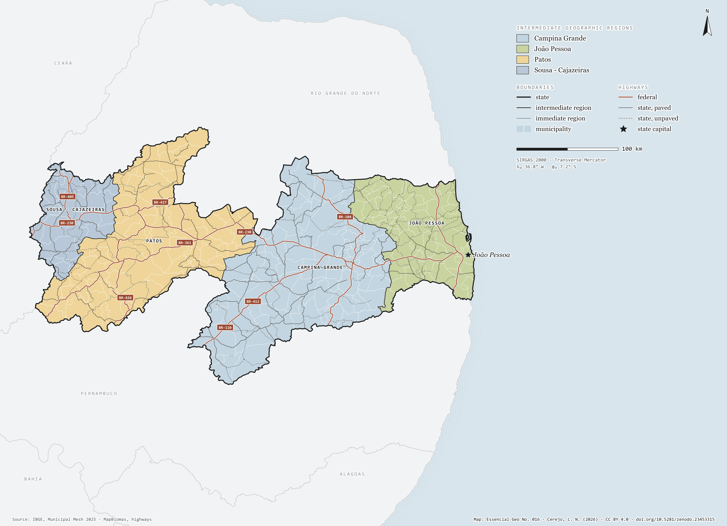
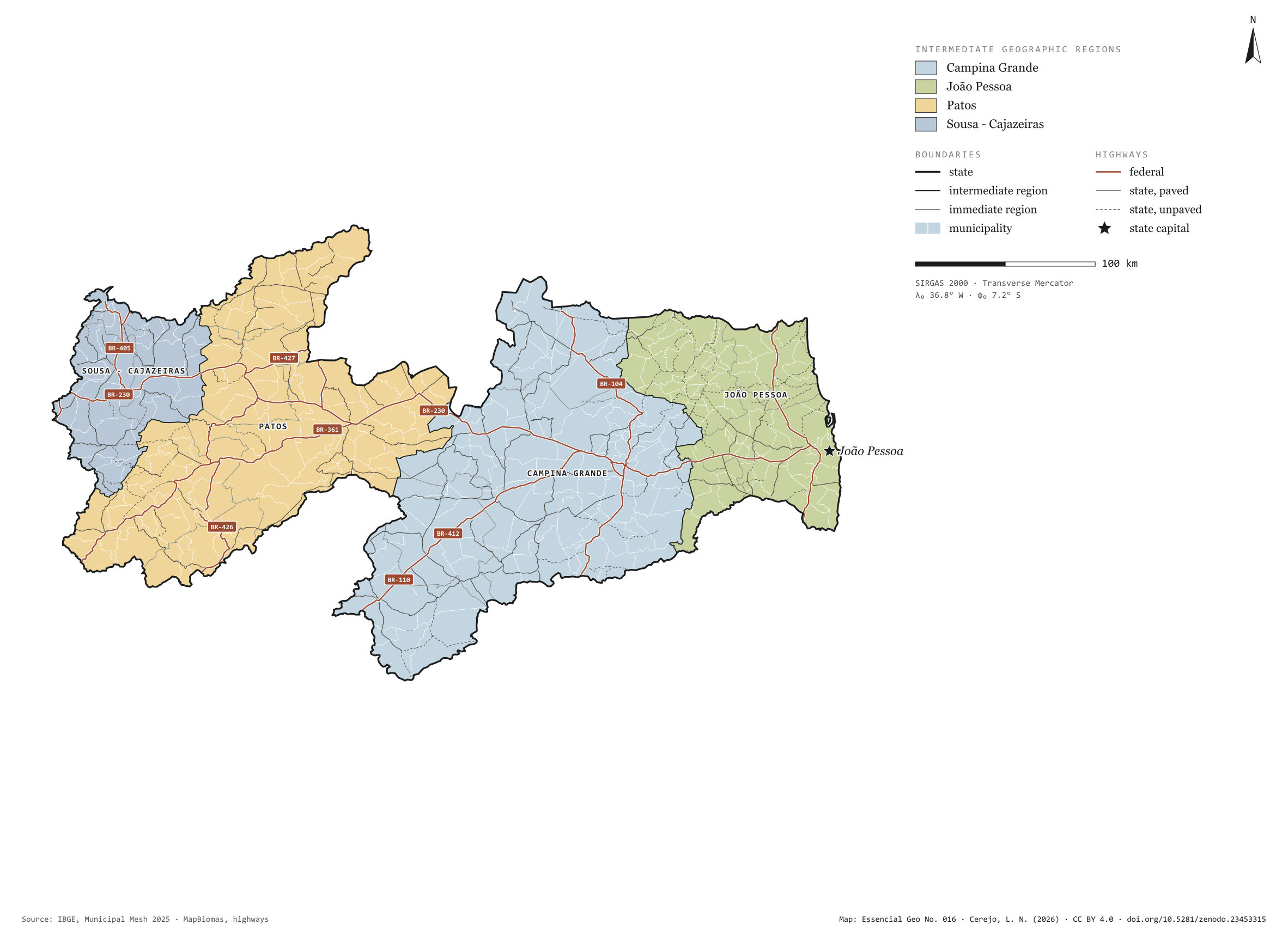
Fig. 016Paraíba state (PB)EPSG:4674Source: IBGE, MapBiomas, Natural Earth
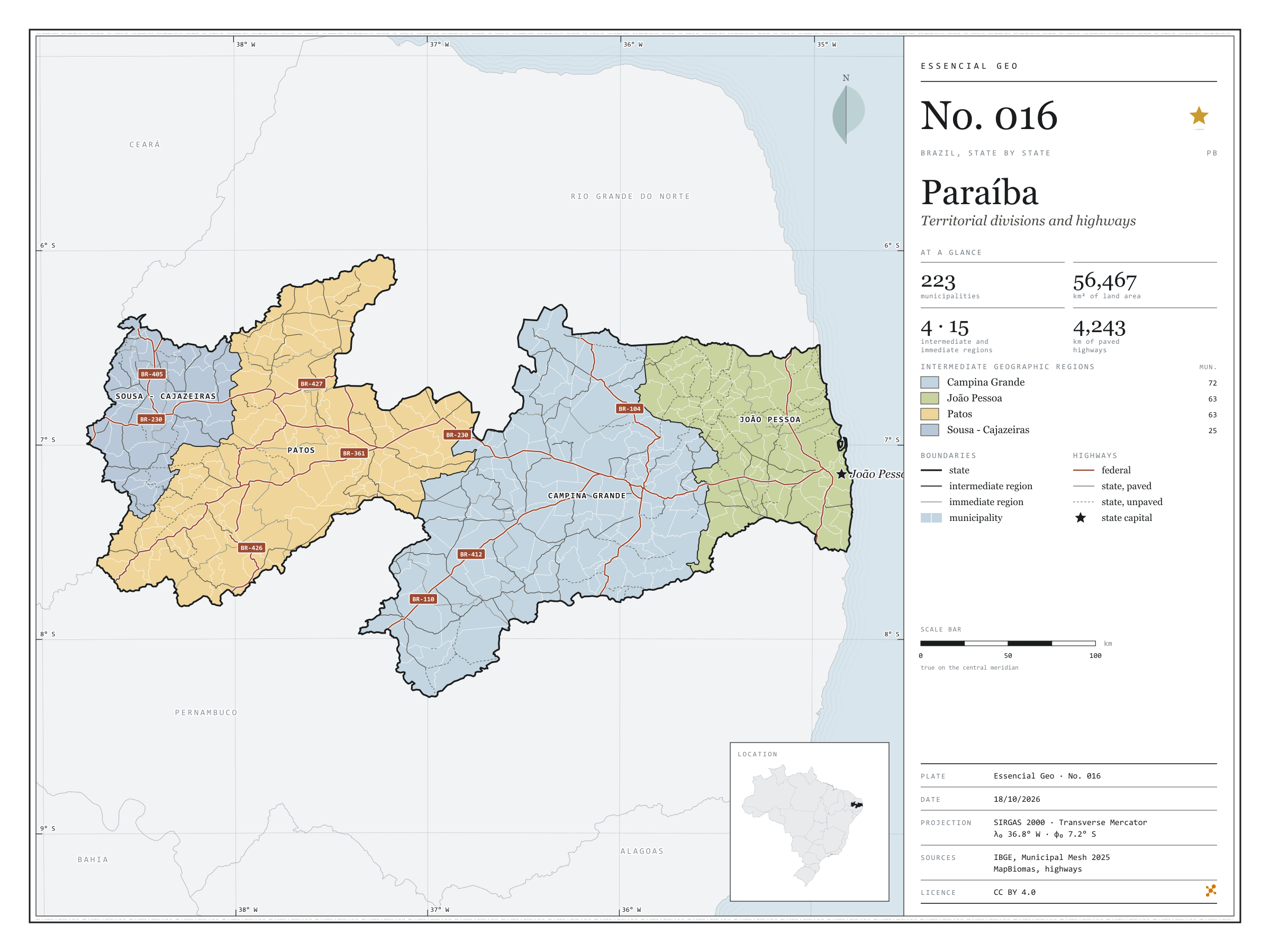
Paraíba has 223 municipalities across 56,000 km², 0.7 per cent of Brazil. IBGE groups them into 15 immediate regions, drawn around the towns that supply jobs, trade and services to their surroundings, and into 4 intermediate regions that tie those networks together. Campina Grande is the intermediate region with the most municipalities (72); Sousa - Cajazeiras, the one with the fewest (25). The largest municipality is Monteiro (993 km²); the smallest, Borborema (26 km²). Part of the series “Brazil, state by state”: a clean base, with official boundaries and the road network, to start a map without losing the first afternoon gathering files.
Technical record · downloads · citation
At a glance
Municipalities per intermediate region (municipalities)
Campina Grande72
João Pessoa63
Patos63
Sousa - Cajazeiras25
Area
56,467km²
Largest municipality: Monteiro (993 km²); smallest: Borborema (26 km²)
Paved highways
4,243km
1,469 km federal and 4,178 km state highways, paved or not
Layers
municipiospolygon223 municipalities, with IBGE code, regions, urban concentration and area (km²)
regioes_intermediariaspolygon4 intermediate geographic regions
regioes_imediataspolygon15 immediate geographic regions
limite_estadualpolygonBoundary of the federative unit
rodoviaslineFederal and state highways: route number, surface, physical status, carriageways
capitalpointIndicative point for the capital (not the exact seat)
The map without a frame, with legend, scale, reference system and credit written on it: ready for papers, lectures and slides. In two versions: with the basemap (neighbours and sea) or only the mapped area, on white.
CEREJO, Lucas Nakamura. Paraíba: divisão territorial e rodovias. Versão 1.0.0. [S. l.]: Zenodo, 2026. Conjunto de dados. DOI: 10.5281/zenodo.23453315. Disponível em: https://doi.org/10.5281/zenodo.23453315. Acesso em: 10 nov. 2026.
Cerejo, L. N. (2026). Paraíba: divisão territorial e rodovias [Paraíba: Territorial divisions and highways] (Version 1.0.0) [Data set]. Zenodo. https://doi.org/10.5281/zenodo.23453315
@dataset{cerejo2026_estado_paraiba,
  author    = {Cerejo, Lucas Nakamura},
  title     = {Paraíba: Divisão territorial e rodovias},
  year      = {2026},
  publisher = {Zenodo},
  version   = {1.0.0},
  doi       = {10.5281/zenodo.23453315},
  url       = {https://doi.org/10.5281/zenodo.23453315},
  language  = {portuguese},
  note      = {English title: Paraíba: Territorial divisions and highways. Licence CC BY 4.0}
}
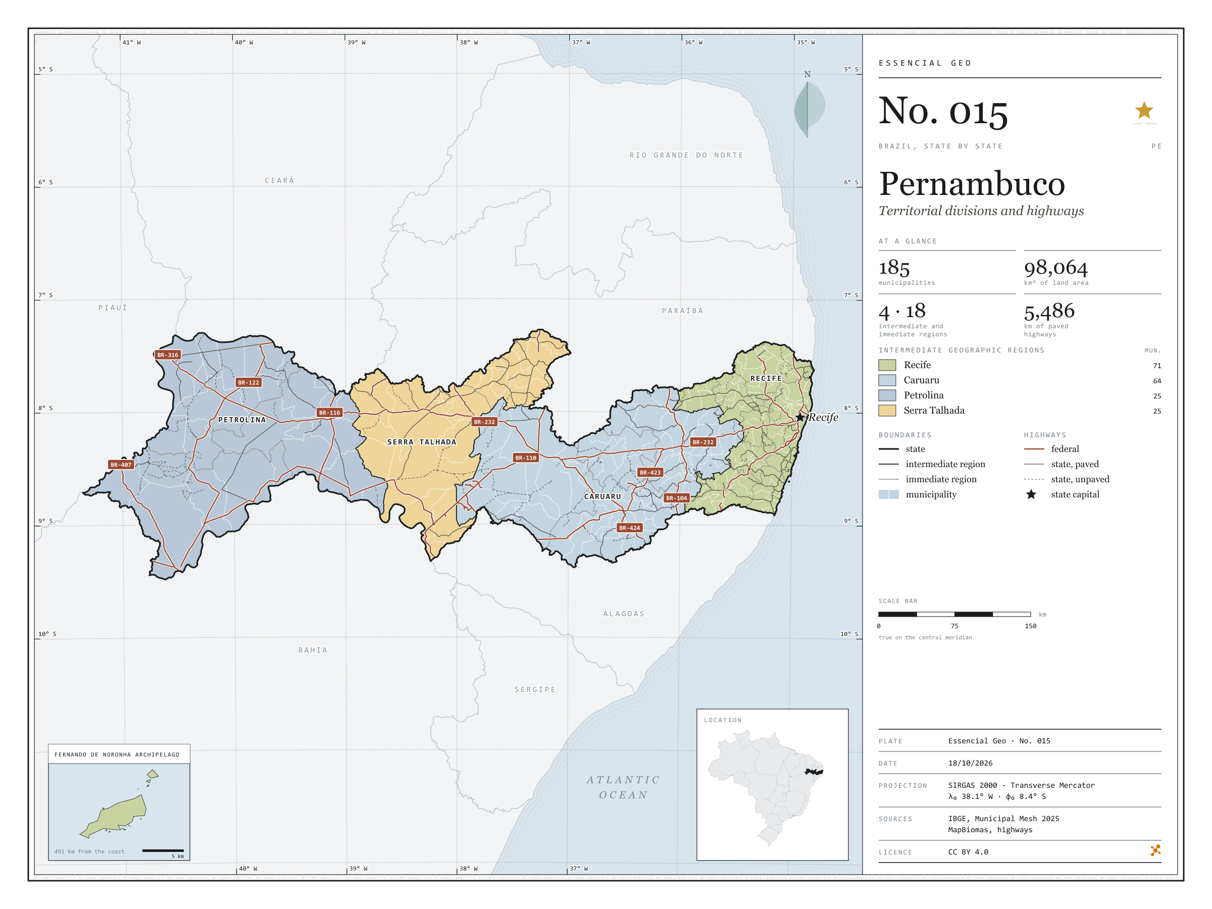
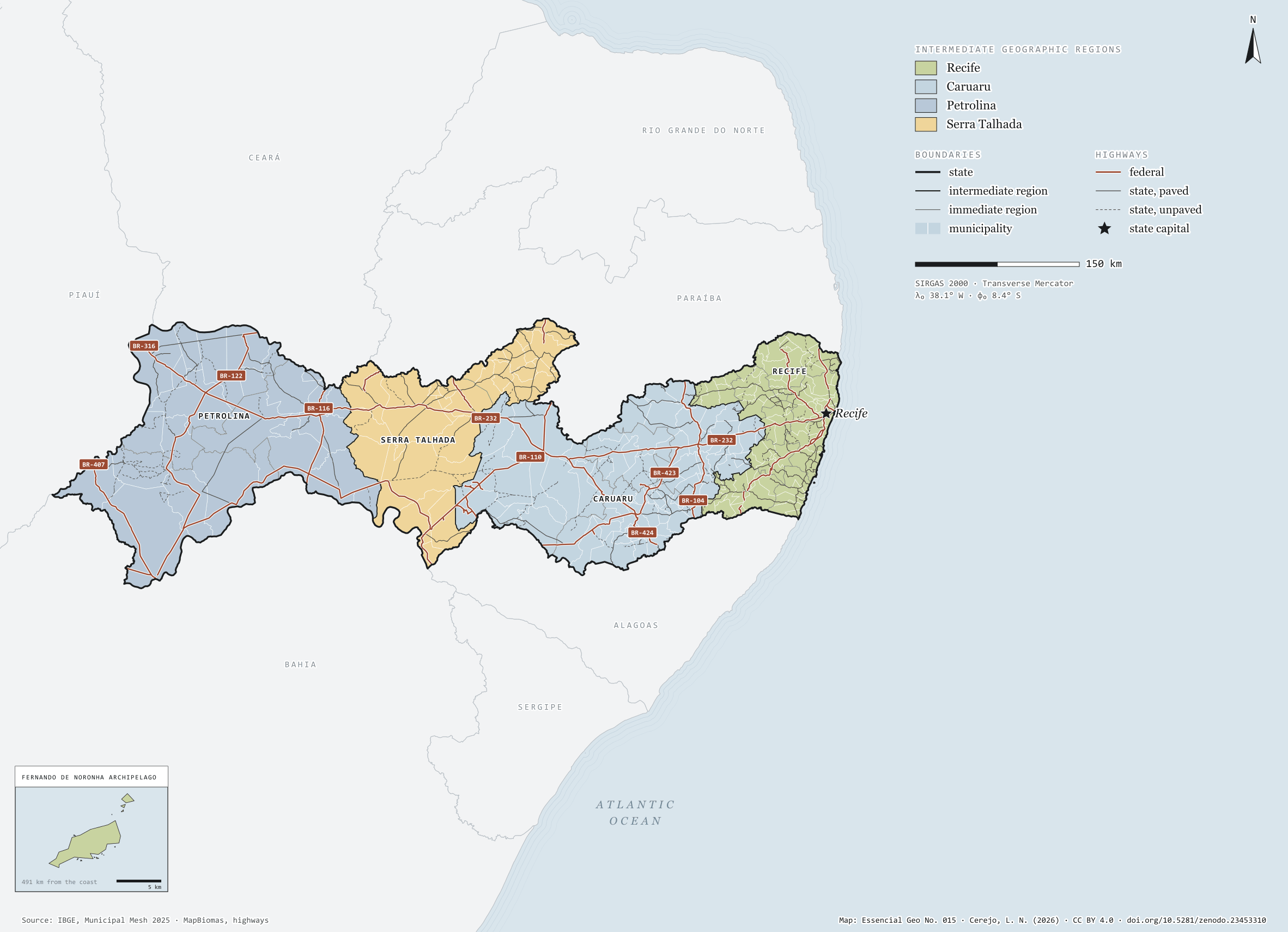
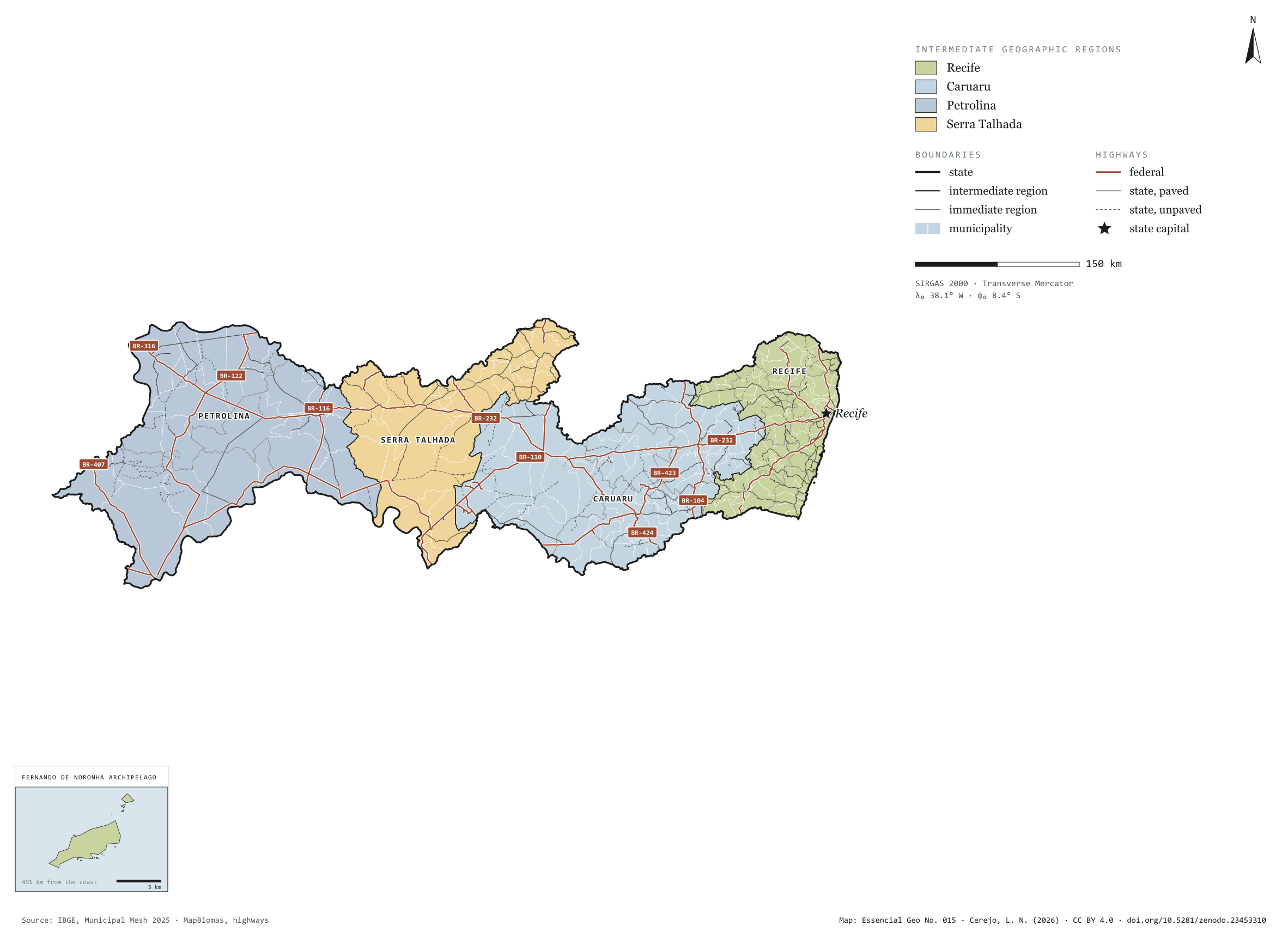
Fig. 015Pernambuco state (PE)EPSG:4674Source: IBGE, MapBiomas, Natural Earth
Pernambuco has 185 municipalities across 98,000 km², 1.2 per cent of Brazil. IBGE groups them into 18 immediate regions, drawn around the towns that supply jobs, trade and services to their surroundings, and into 4 intermediate regions that tie those networks together. Recife is the intermediate region with the most municipalities (71); Serra Talhada, the one with the fewest (25). The largest municipality is Petrolina (4,559 km²); the smallest, Fernando de Noronha (19 km²). Part of the series “Brazil, state by state”: a clean base, with official boundaries and the road network, to start a map without losing the first afternoon gathering files.
Technical record · downloads · citation
At a glance
Municipalities per intermediate region (municipalities)
Recife71
Caruaru64
Petrolina25
Serra Talhada25
Area
98,064km²
Largest municipality: Petrolina (4,559 km²); smallest: Fernando de Noronha (19 km²)
Paved highways
5,486km
2,701 km federal and 4,823 km state highways, paved or not
Layers
municipiospolygon185 municipalities, with IBGE code, regions, urban concentration and area (km²)
regioes_intermediariaspolygon4 intermediate geographic regions
regioes_imediataspolygon18 immediate geographic regions
limite_estadualpolygonBoundary of the federative unit
rodoviaslineFederal and state highways: route number, surface, physical status, carriageways
capitalpointIndicative point for the capital (not the exact seat)
The map without a frame, with legend, scale, reference system and credit written on it: ready for papers, lectures and slides. In two versions: with the basemap (neighbours and sea) or only the mapped area, on white.
CEREJO, Lucas Nakamura. Pernambuco: divisão territorial e rodovias. Versão 1.0.0. [S. l.]: Zenodo, 2026. Conjunto de dados. DOI: 10.5281/zenodo.23453310. Disponível em: https://doi.org/10.5281/zenodo.23453310. Acesso em: 10 nov. 2026.
Cerejo, L. N. (2026). Pernambuco: divisão territorial e rodovias [Pernambuco: Territorial divisions and highways] (Version 1.0.0) [Data set]. Zenodo. https://doi.org/10.5281/zenodo.23453310
@dataset{cerejo2026_estado_pernambuco,
  author    = {Cerejo, Lucas Nakamura},
  title     = {Pernambuco: Divisão territorial e rodovias},
  year      = {2026},
  publisher = {Zenodo},
  version   = {1.0.0},
  doi       = {10.5281/zenodo.23453310},
  url       = {https://doi.org/10.5281/zenodo.23453310},
  language  = {portuguese},
  note      = {English title: Pernambuco: Territorial divisions and highways. Licence CC BY 4.0}
}
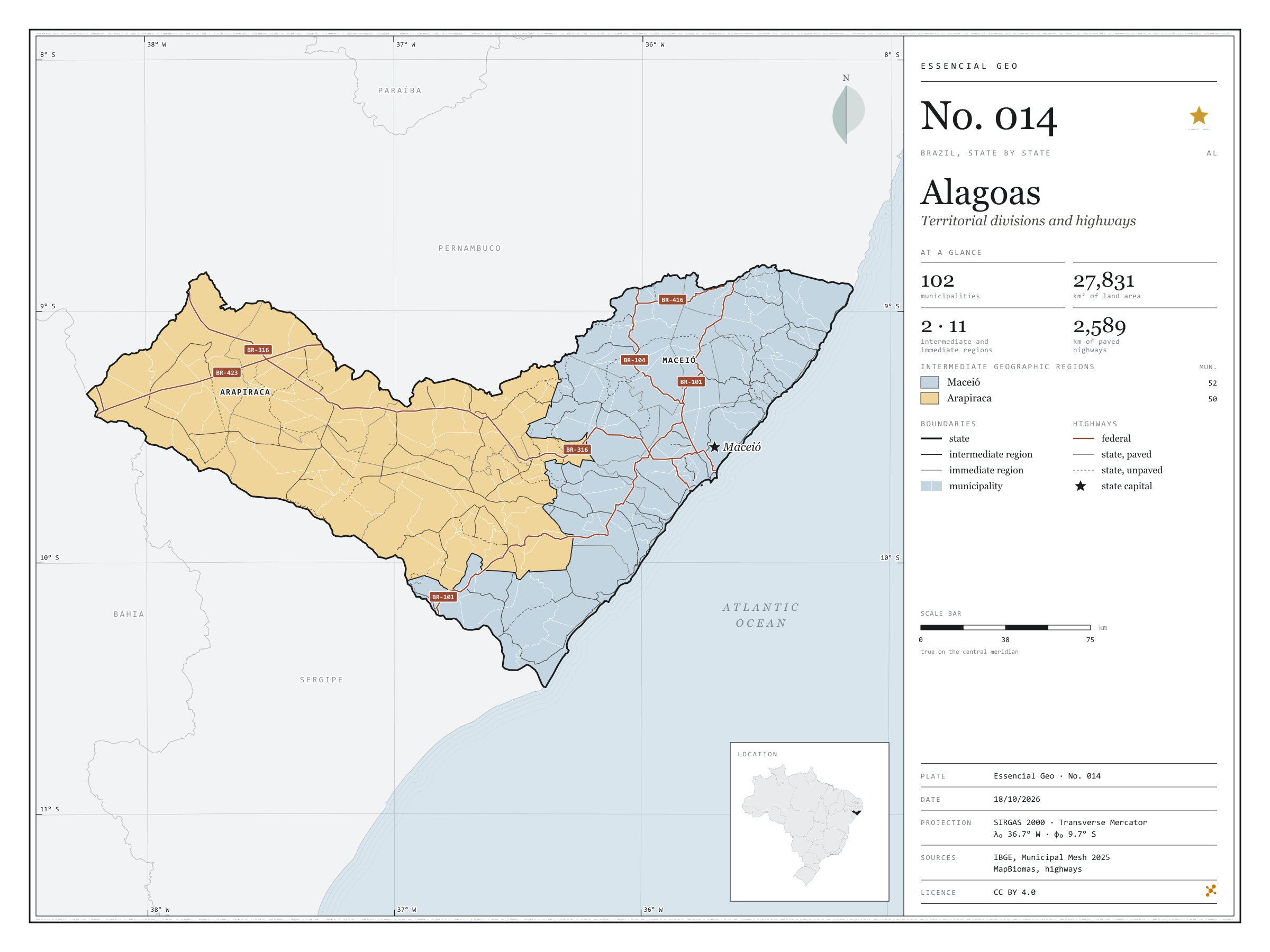
Fig. 014Alagoas state (AL)EPSG:4674Source: IBGE, MapBiomas, Natural Earth
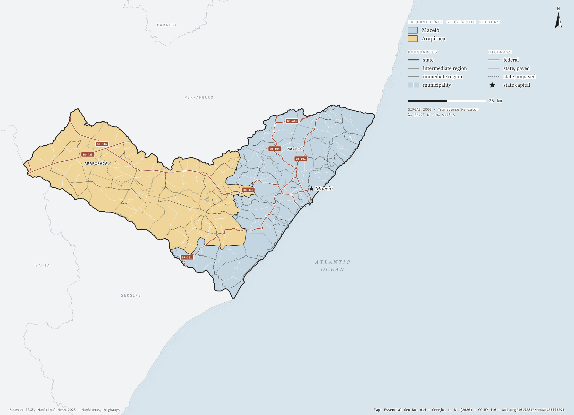
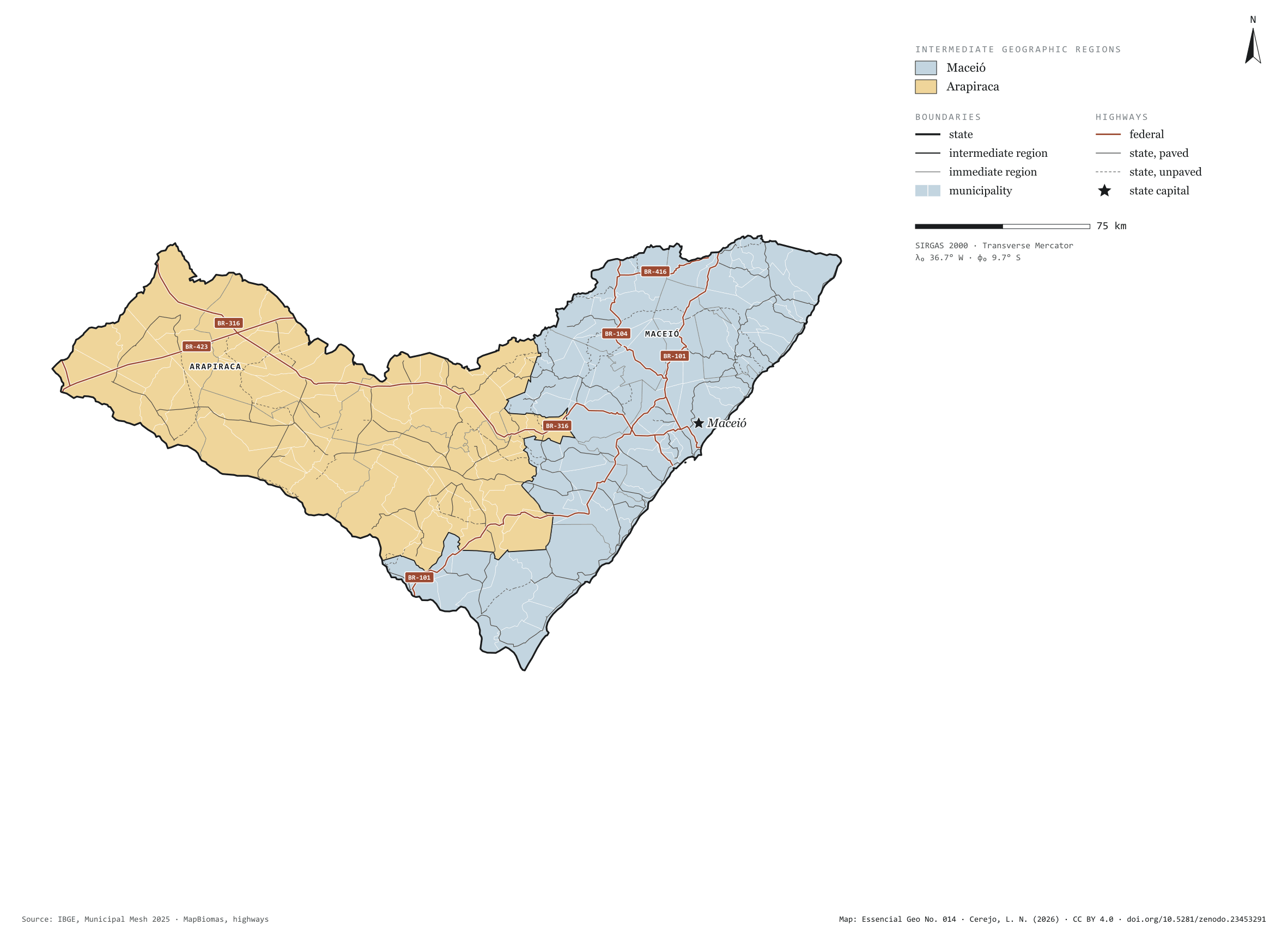
Alagoas has 102 municipalities across 28,000 km², 0.3 per cent of Brazil. IBGE groups them into 11 immediate regions, drawn around the towns that supply jobs, trade and services to their surroundings, and into 2 intermediate regions that tie those networks together. Maceió is the intermediate region with the most municipalities (52); Arapiraca, the one with the fewest (50). The largest municipality is Mata Grande (910 km²); the smallest, Santa Luzia do Norte (29 km²). Part of the series “Brazil, state by state”: a clean base, with official boundaries and the road network, to start a map without losing the first afternoon gathering files.
Technical record · downloads · citation
At a glance
Municipalities per intermediate region (municipalities)
Maceió52
Arapiraca50
Area
27,831km²
Largest municipality: Mata Grande (910 km²); smallest: Santa Luzia do Norte (29 km²)
Paved highways
2,589km
805 km federal and 2,441 km state highways, paved or not
Layers
municipiospolygon102 municipalities, with IBGE code, regions, urban concentration and area (km²)
regioes_intermediariaspolygon2 intermediate geographic regions
regioes_imediataspolygon11 immediate geographic regions
limite_estadualpolygonBoundary of the federative unit
rodoviaslineFederal and state highways: route number, surface, physical status, carriageways
capitalpointIndicative point for the capital (not the exact seat)
The map without a frame, with legend, scale, reference system and credit written on it: ready for papers, lectures and slides. In two versions: with the basemap (neighbours and sea) or only the mapped area, on white.
CEREJO, Lucas Nakamura. Alagoas: divisão territorial e rodovias. Versão 1.0.0. [S. l.]: Zenodo, 2026. Conjunto de dados. DOI: 10.5281/zenodo.23453291. Disponível em: https://doi.org/10.5281/zenodo.23453291. Acesso em: 10 nov. 2026.
Cerejo, L. N. (2026). Alagoas: divisão territorial e rodovias [Alagoas: Territorial divisions and highways] (Version 1.0.0) [Data set]. Zenodo. https://doi.org/10.5281/zenodo.23453291
@dataset{cerejo2026_estado_alagoas,
  author    = {Cerejo, Lucas Nakamura},
  title     = {Alagoas: Divisão territorial e rodovias},
  year      = {2026},
  publisher = {Zenodo},
  version   = {1.0.0},
  doi       = {10.5281/zenodo.23453291},
  url       = {https://doi.org/10.5281/zenodo.23453291},
  language  = {portuguese},
  note      = {English title: Alagoas: Territorial divisions and highways. Licence CC BY 4.0}
}
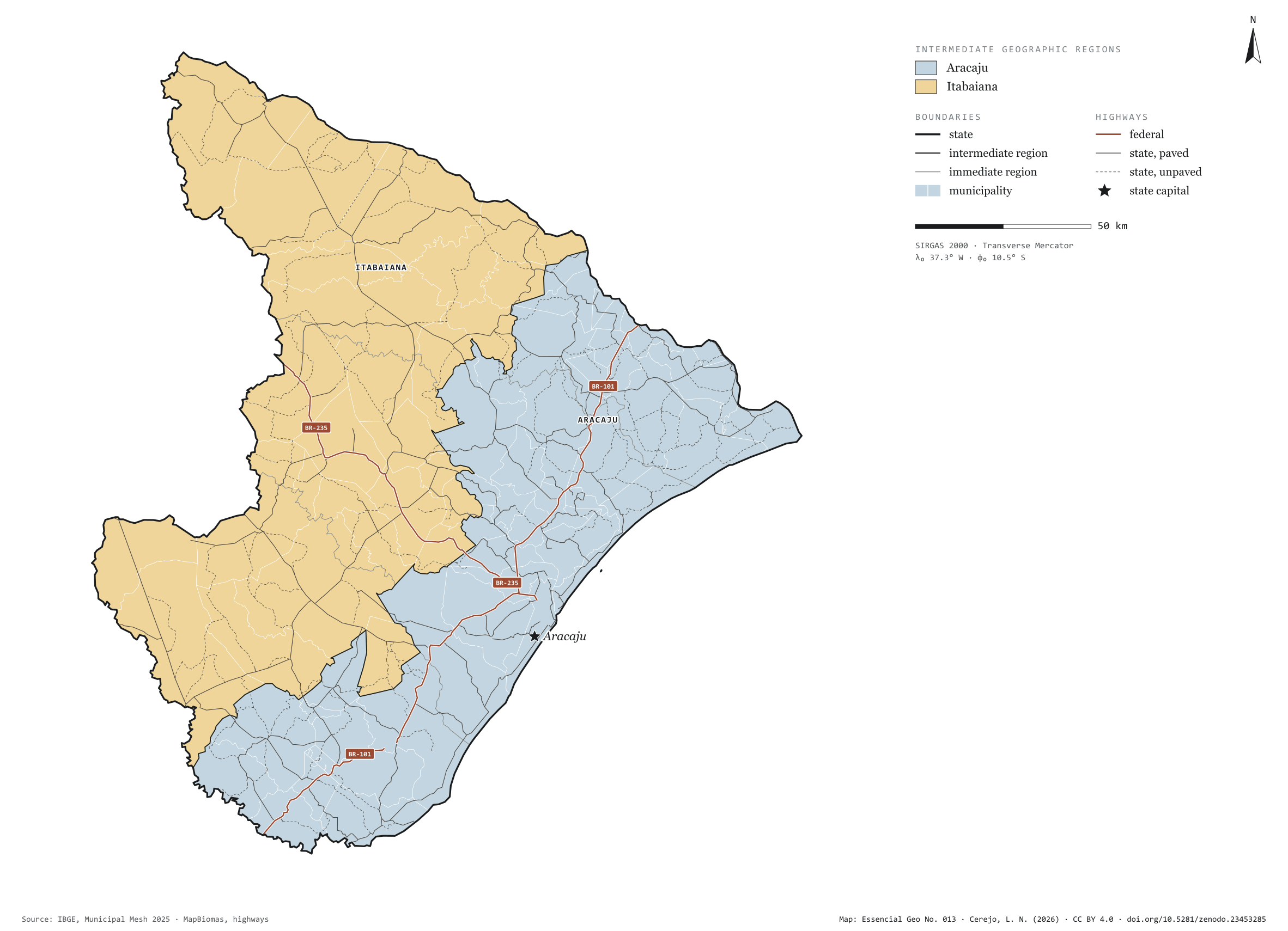
Fig. 013Sergipe state (SE)EPSG:4674Source: IBGE, MapBiomas, Natural Earth
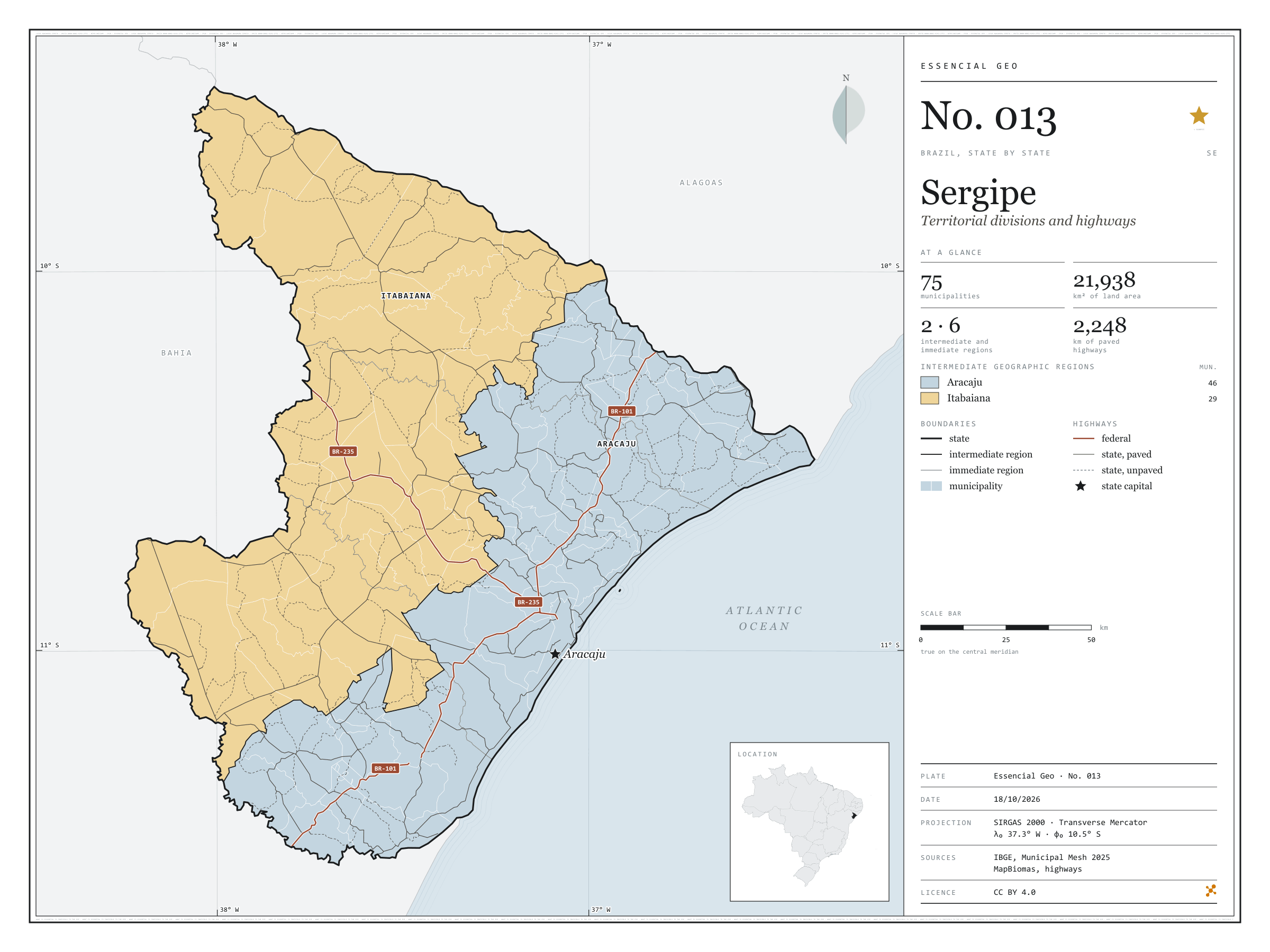
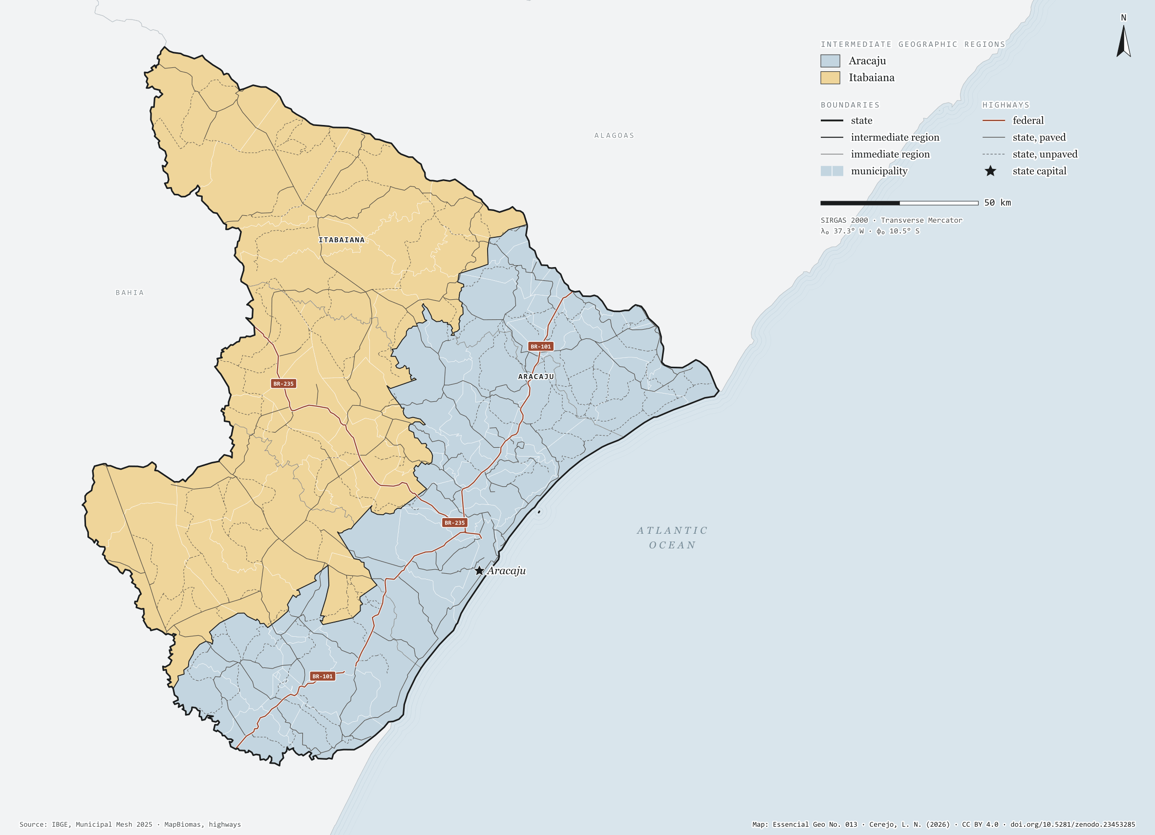
Sergipe has 75 municipalities across 22,000 km², 0.3 per cent of Brazil. IBGE groups them into 6 immediate regions, drawn around the towns that supply jobs, trade and services to their surroundings, and into 2 intermediate regions that tie those networks together. Aracaju is the intermediate region with the most municipalities (46); Itabaiana, the one with the fewest (29). The largest municipality is Canindé de São Francisco (1,080 km²); the smallest, General Maynard (20 km²). Part of the series “Brazil, state by state”: a clean base, with official boundaries and the road network, to start a map without losing the first afternoon gathering files.
Technical record · downloads · citation
At a glance
Municipalities per intermediate region (municipalities)
Aracaju46
Itabaiana29
Area
21,938km²
Largest municipality: Canindé de São Francisco (1,080 km²); smallest: General Maynard (20 km²)
Paved highways
2,248km
316 km federal and 3,751 km state highways, paved or not
Layers
municipiospolygon75 municipalities, with IBGE code, regions, urban concentration and area (km²)
regioes_intermediariaspolygon2 intermediate geographic regions
regioes_imediataspolygon6 immediate geographic regions
limite_estadualpolygonBoundary of the federative unit
rodoviaslineFederal and state highways: route number, surface, physical status, carriageways
capitalpointIndicative point for the capital (not the exact seat)
The map without a frame, with legend, scale, reference system and credit written on it: ready for papers, lectures and slides. In two versions: with the basemap (neighbours and sea) or only the mapped area, on white.
CEREJO, Lucas Nakamura. Sergipe: divisão territorial e rodovias. Versão 1.0.0. [S. l.]: Zenodo, 2026. Conjunto de dados. DOI: 10.5281/zenodo.23453285. Disponível em: https://doi.org/10.5281/zenodo.23453285. Acesso em: 10 nov. 2026.
Cerejo, L. N. (2026). Sergipe: divisão territorial e rodovias [Sergipe: Territorial divisions and highways] (Version 1.0.0) [Data set]. Zenodo. https://doi.org/10.5281/zenodo.23453285
@dataset{cerejo2026_estado_sergipe,
  author    = {Cerejo, Lucas Nakamura},
  title     = {Sergipe: Divisão territorial e rodovias},
  year      = {2026},
  publisher = {Zenodo},
  version   = {1.0.0},
  doi       = {10.5281/zenodo.23453285},
  url       = {https://doi.org/10.5281/zenodo.23453285},
  language  = {portuguese},
  note      = {English title: Sergipe: Territorial divisions and highways. Licence CC BY 4.0}
}
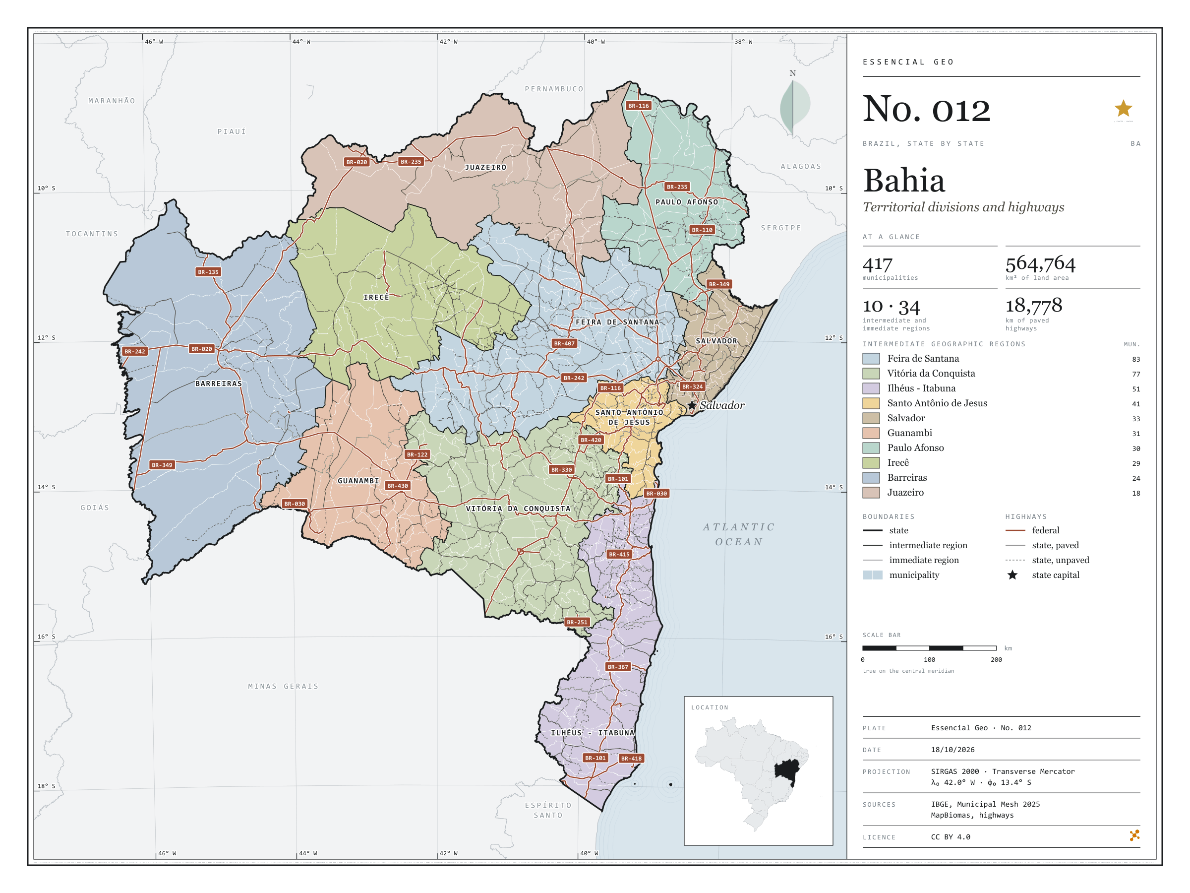
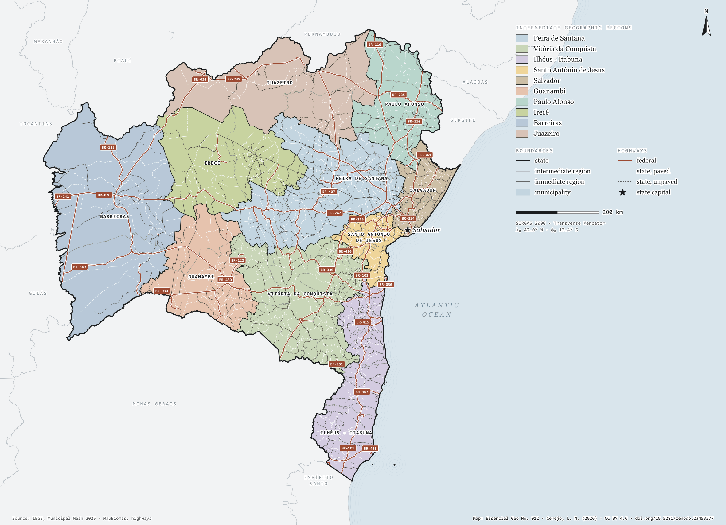
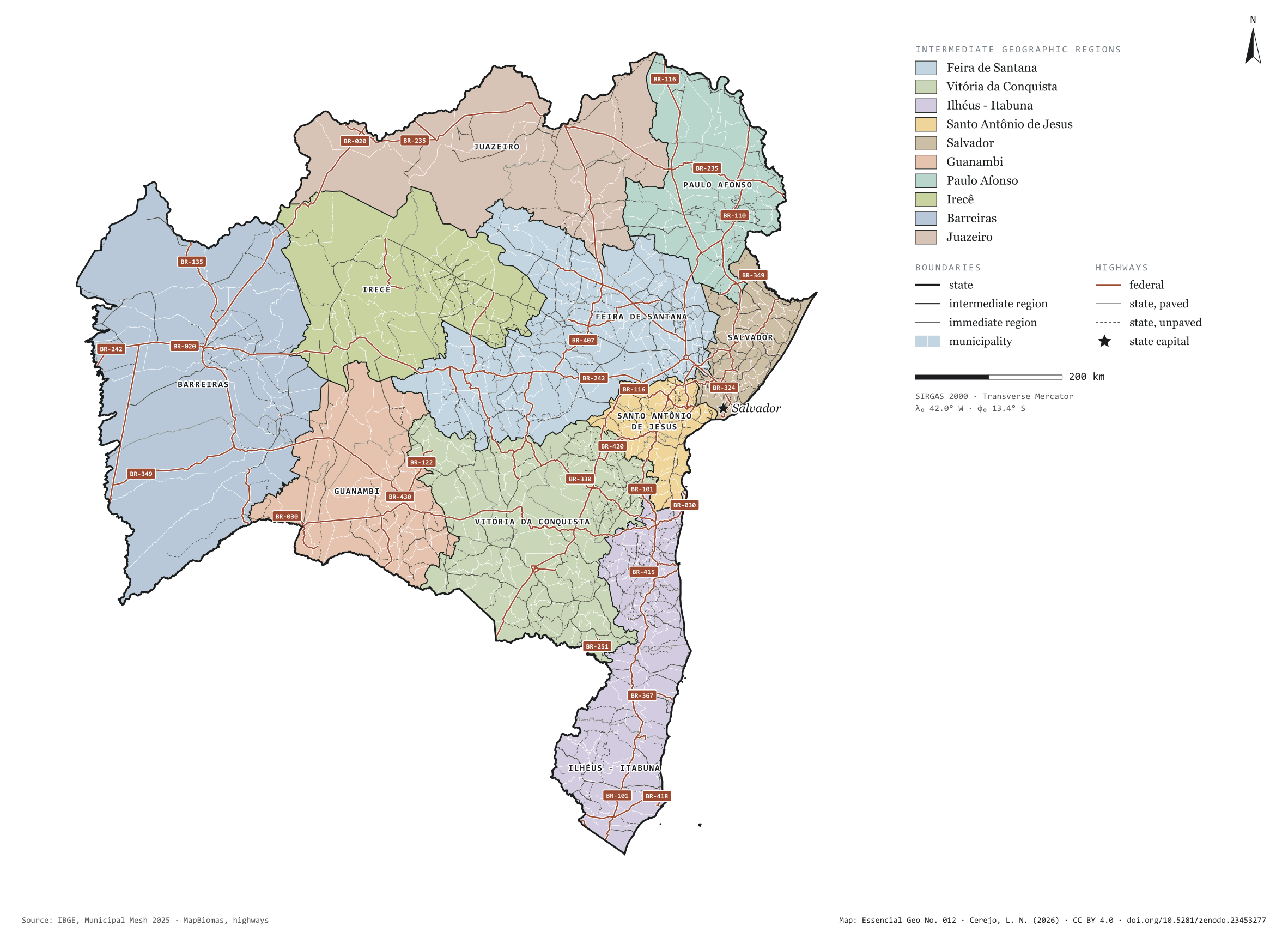
Fig. 012Bahia state (BA)EPSG:4674Source: IBGE, MapBiomas, Natural Earth
Bahia has 417 municipalities across 565,000 km², 6.6 per cent of Brazil. IBGE groups them into 34 immediate regions, drawn around the towns that supply jobs, trade and services to their surroundings, and into 10 intermediate regions that tie those networks together. Feira de Santana is the intermediate region with the most municipalities (83); Juazeiro, the one with the fewest (18). The largest municipality is Formosa do Rio Preto (15,634 km²); the smallest, Madre de Deus (33 km²). Part of the series “Brazil, state by state”: a clean base, with official boundaries and the road network, to start a map without losing the first afternoon gathering files.
Technical record · downloads · citation
At a glance
Municipalities per intermediate region (municipalities)
Feira de Santana83
Vitória da Conquista77
Ilhéus - Itabuna51
Santo Antônio de Jesus41
Salvador33
Guanambi31
Paulo Afonso30
Irecê29
Barreiras24
Juazeiro18
Area
564,764km²
Largest municipality: Formosa do Rio Preto (15,634 km²); smallest: Madre de Deus (33 km²)
Paved highways
18,778km
8,906 km federal and 21,586 km state highways, paved or not
Layers
municipiospolygon417 municipalities, with IBGE code, regions, urban concentration and area (km²)
regioes_intermediariaspolygon10 intermediate geographic regions
regioes_imediataspolygon34 immediate geographic regions
limite_estadualpolygonBoundary of the federative unit
rodoviaslineFederal and state highways: route number, surface, physical status, carriageways
capitalpointIndicative point for the capital (not the exact seat)
The map without a frame, with legend, scale, reference system and credit written on it: ready for papers, lectures and slides. In two versions: with the basemap (neighbours and sea) or only the mapped area, on white.
CEREJO, Lucas Nakamura. Bahia: divisão territorial e rodovias. Versão 1.0.0. [S. l.]: Zenodo, 2026. Conjunto de dados. DOI: 10.5281/zenodo.23453277. Disponível em: https://doi.org/10.5281/zenodo.23453277. Acesso em: 10 nov. 2026.
Cerejo, L. N. (2026). Bahia: divisão territorial e rodovias [Bahia: Territorial divisions and highways] (Version 1.0.0) [Data set]. Zenodo. https://doi.org/10.5281/zenodo.23453277
@dataset{cerejo2026_estado_bahia,
  author    = {Cerejo, Lucas Nakamura},
  title     = {Bahia: Divisão territorial e rodovias},
  year      = {2026},
  publisher = {Zenodo},
  version   = {1.0.0},
  doi       = {10.5281/zenodo.23453277},
  url       = {https://doi.org/10.5281/zenodo.23453277},
  language  = {portuguese},
  note      = {English title: Bahia: Territorial divisions and highways. Licence CC BY 4.0}
}
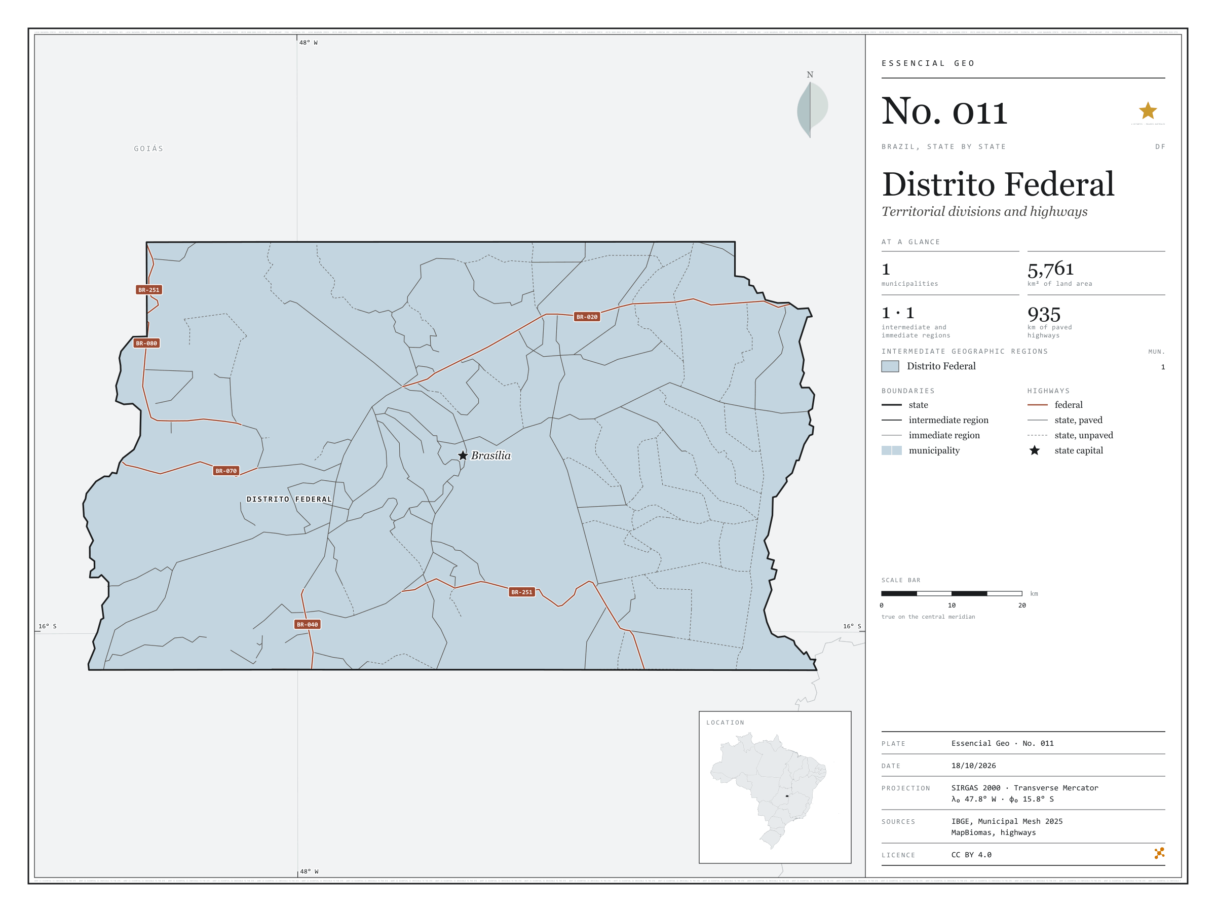
Fig. 011Federal District (DF)EPSG:4674Source: IBGE, MapBiomas, Natural Earth
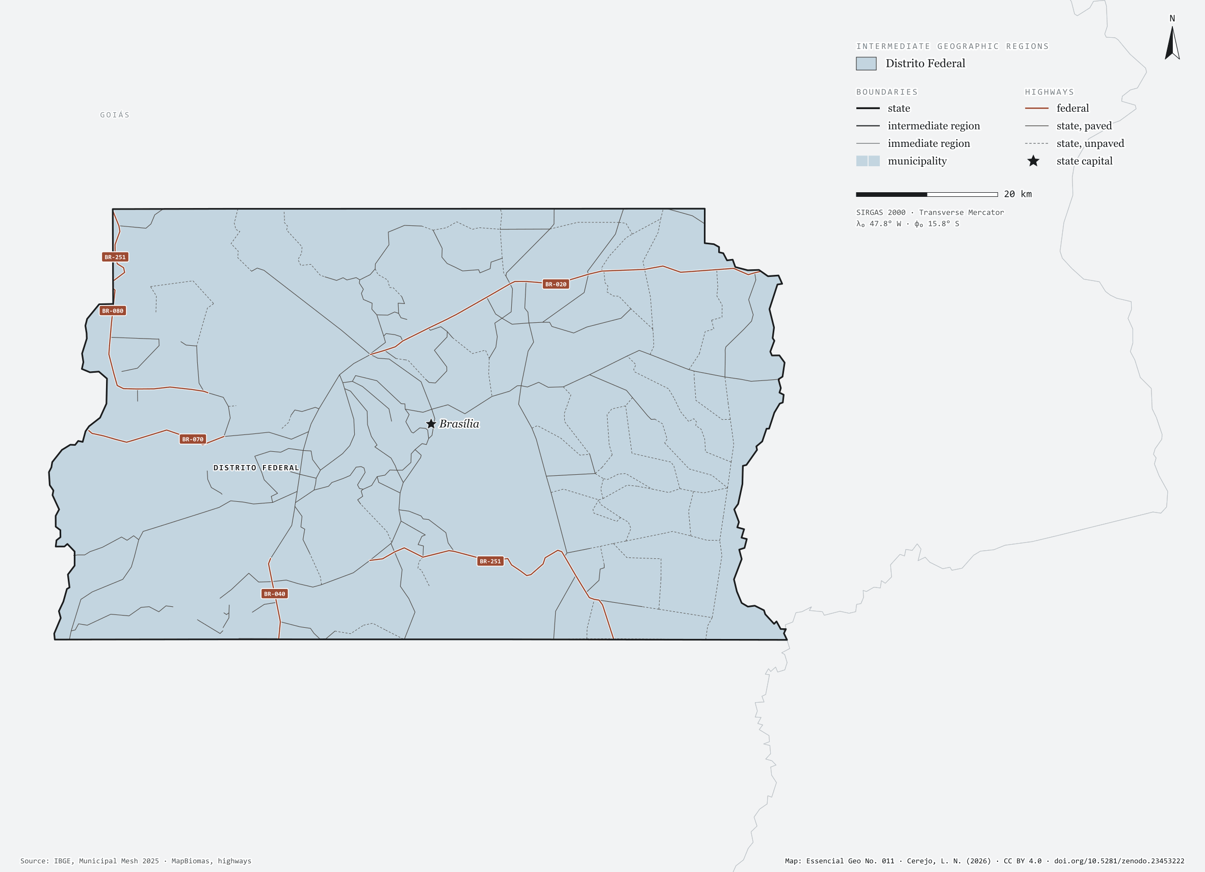
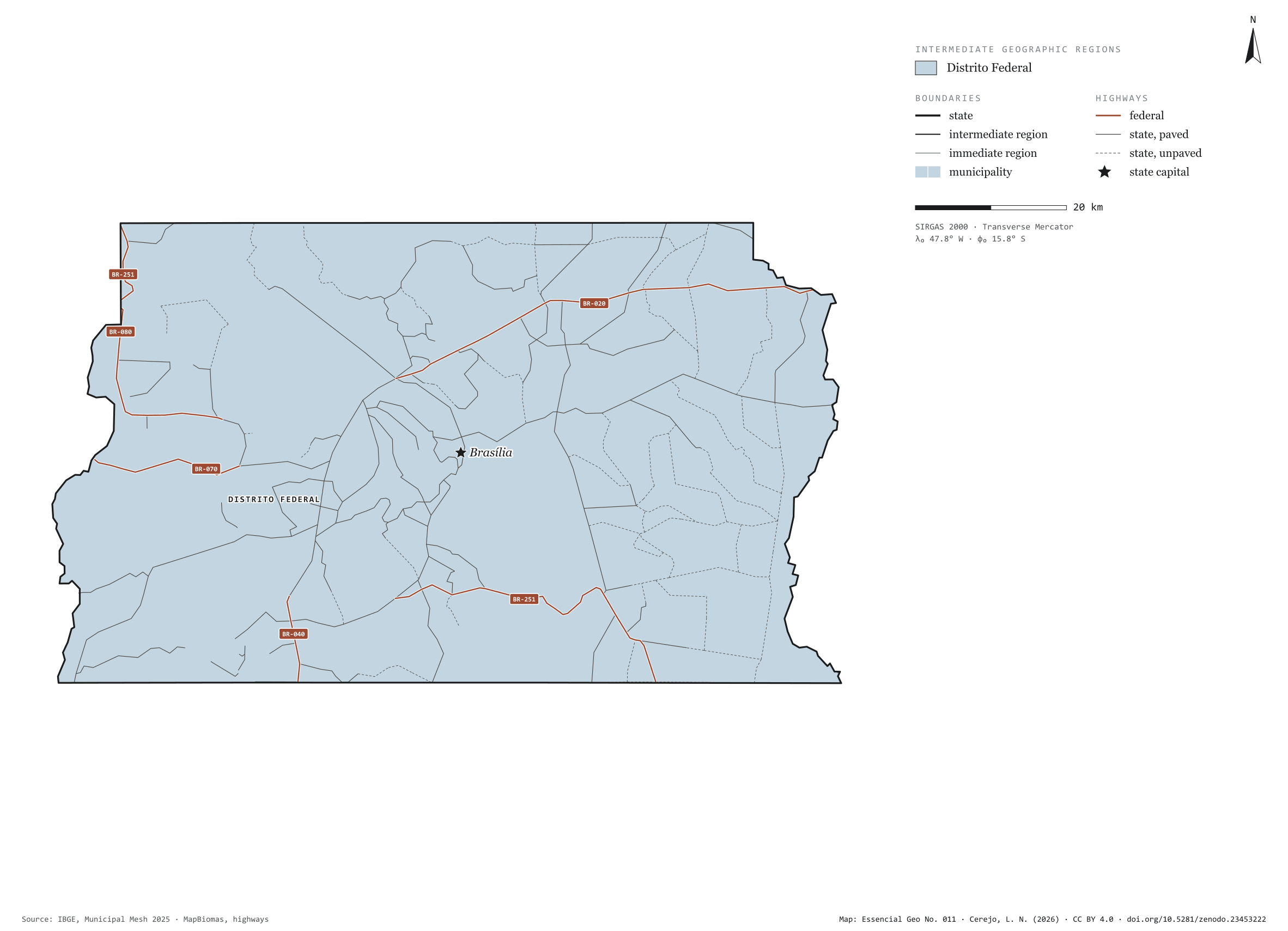
The Federal District is not divided into municipalities: in the IBGE mesh it is a single one, Brasília, with 5,761 km². On its own it is also one immediate region and one intermediate region. The smallest federative unit sits on the Central Plateau, between Goiás and Minas Gerais, and the radial federal highways, numbered BR-010 to BR-080, start from it. Part of the series “Brazil, state by state”: a clean base, with official boundaries and the road network, to start a map without losing the first afternoon gathering files.
Technical record · downloads · citation
At a glance
Municipalities per intermediate region (municipalities)
Distrito Federal1
Area
5,761km²
Paved highways
935km
175 km federal and 1,230 km state highways, paved or not
Layers
municipiospolygon1 municipality, with IBGE code, regions, urban concentration and area (km²)
regioes_intermediariaspolygon1 intermediate geographic region
regioes_imediataspolygon1 immediate geographic region
limite_estadualpolygonBoundary of the federative unit
rodoviaslineFederal and state highways: route number, surface, physical status, carriageways
capitalpointIndicative point for the capital (not the exact seat)
The map without a frame, with legend, scale, reference system and credit written on it: ready for papers, lectures and slides. In two versions: with the basemap (neighbours and sea) or only the mapped area, on white.
CEREJO, Lucas Nakamura. Distrito Federal: divisão territorial e rodovias. Versão 1.0.0. [S. l.]: Zenodo, 2026. Conjunto de dados. DOI: 10.5281/zenodo.23453222. Disponível em: https://doi.org/10.5281/zenodo.23453222. Acesso em: 10 nov. 2026.
Cerejo, L. N. (2026). Distrito Federal: divisão territorial e rodovias [Distrito Federal: Territorial divisions and highways] (Version 1.0.0) [Data set]. Zenodo. https://doi.org/10.5281/zenodo.23453222
@dataset{cerejo2026_distrito_federal,
  author    = {Cerejo, Lucas Nakamura},
  title     = {Distrito Federal: Divisão territorial e rodovias},
  year      = {2026},
  publisher = {Zenodo},
  version   = {1.0.0},
  doi       = {10.5281/zenodo.23453222},
  url       = {https://doi.org/10.5281/zenodo.23453222},
  language  = {portuguese},
  note      = {English title: Distrito Federal: Territorial divisions and highways. Licence CC BY 4.0}
}
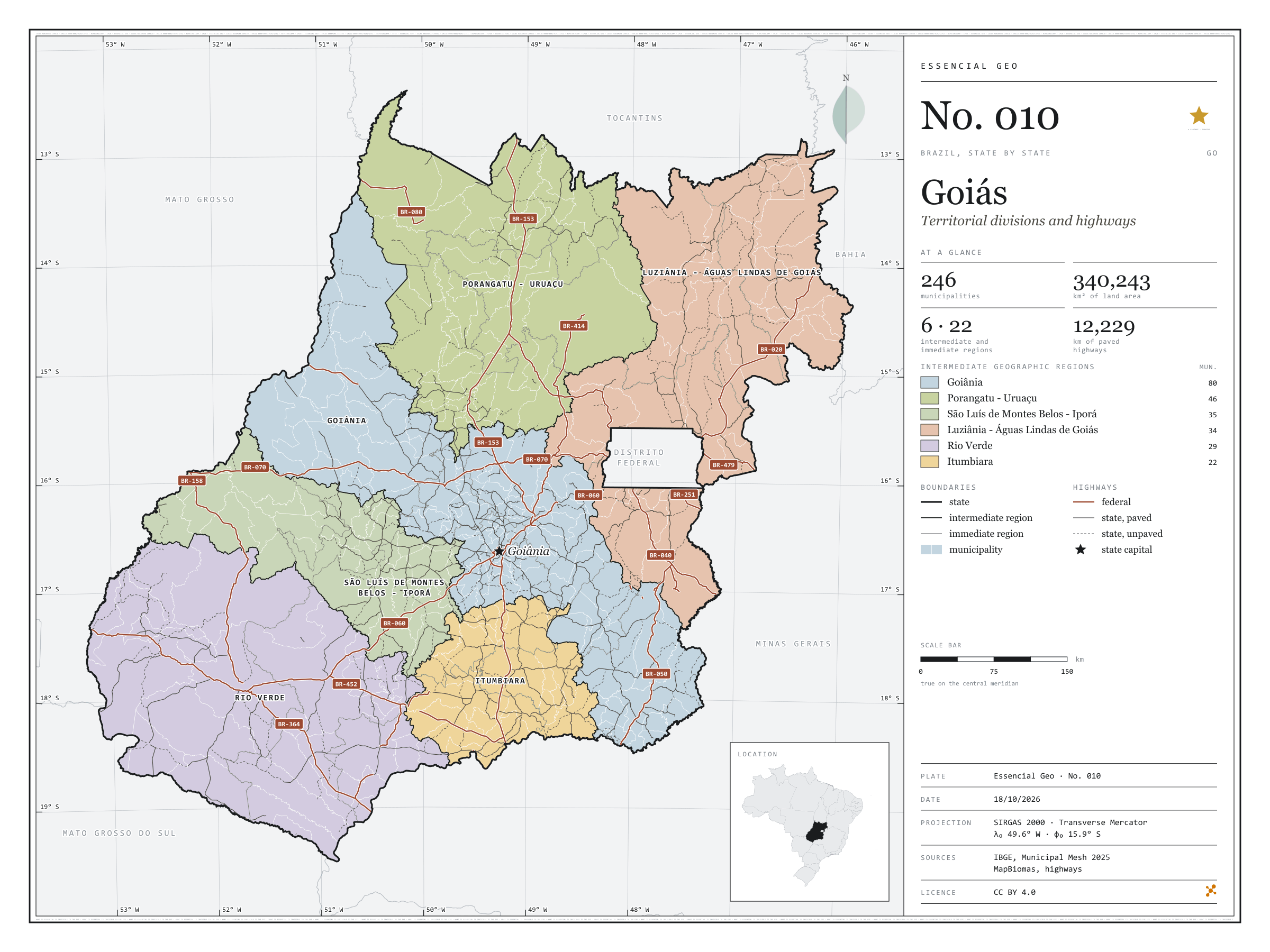
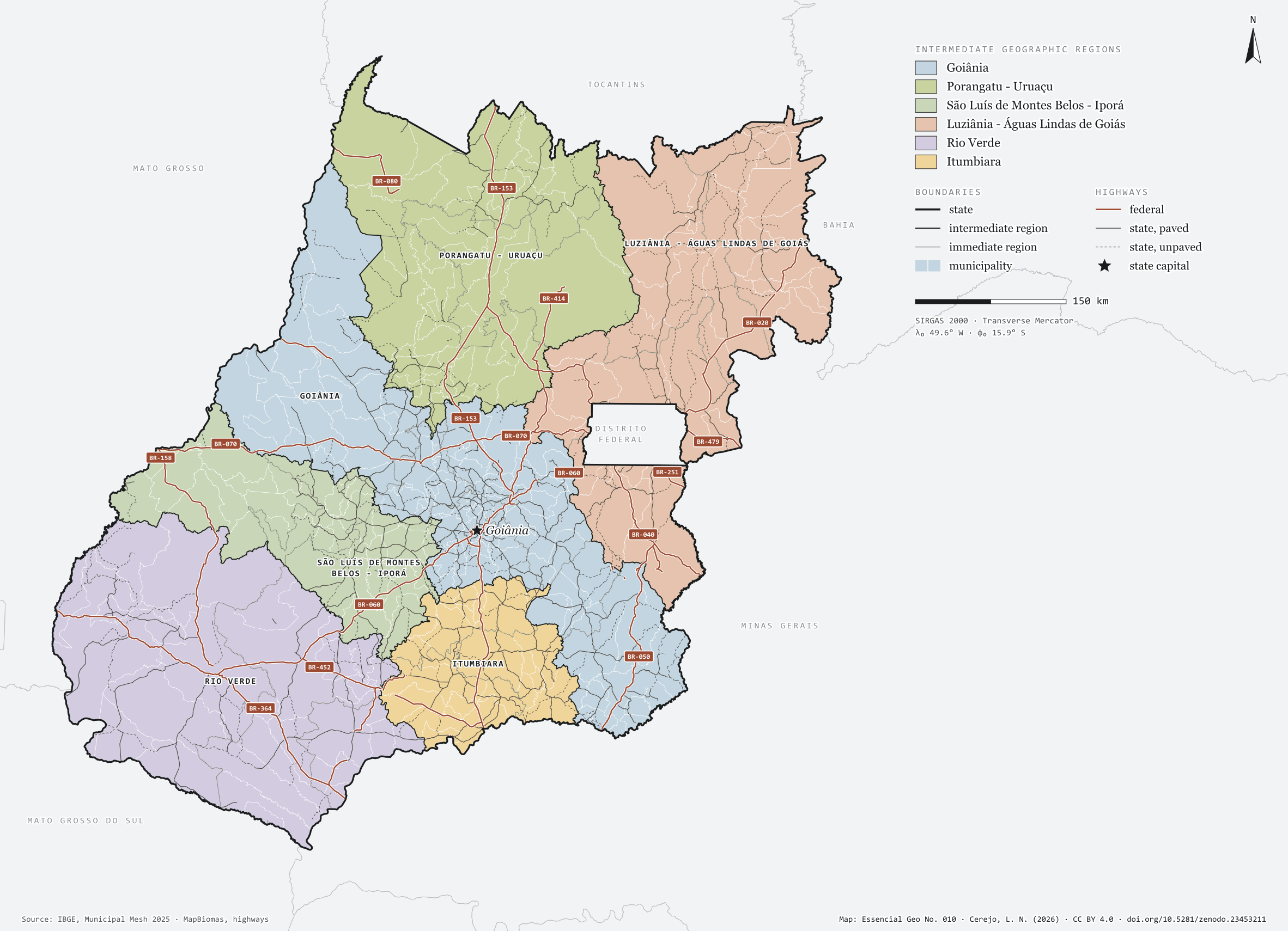
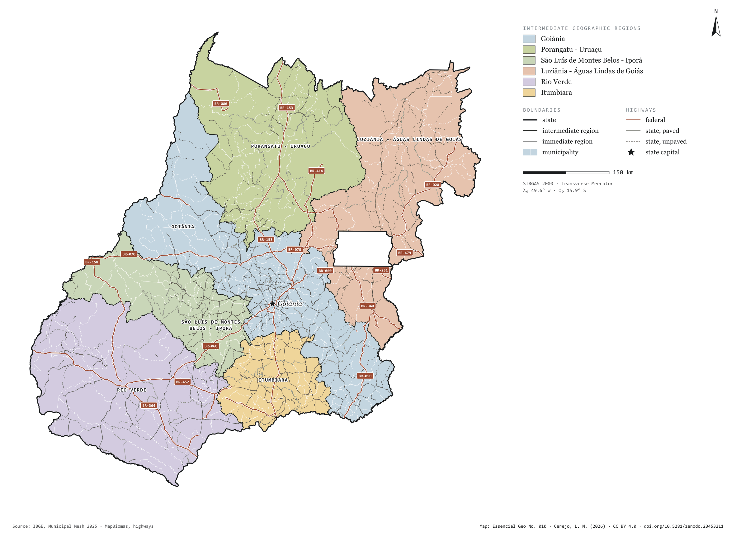
Fig. 010Goiás state (GO)EPSG:4674Source: IBGE, MapBiomas, Natural Earth
Goiás has 246 municipalities across 340,000 km², 4.0 per cent of Brazil. IBGE groups them into 22 immediate regions, drawn around the towns that supply jobs, trade and services to their surroundings, and into 6 intermediate regions that tie those networks together. Goiânia is the intermediate region with the most municipalities (80); Itumbiara, the one with the fewest (22). The largest municipality is Niquelândia (9,846 km²); the smallest, Anhanguera (56 km²). Part of the series “Brazil, state by state”: a clean base, with official boundaries and the road network, to start a map without losing the first afternoon gathering files.
Technical record · downloads · citation
At a glance
Municipalities per intermediate region (municipalities)
Goiânia80
Porangatu - Uruaçu46
São Luís de Montes Belos - Iporá35
Luziânia - Águas Lindas de Goiás34
Rio Verde29
Itumbiara22
Area
340,243km²
Largest municipality: Niquelândia (9,846 km²); smallest: Anhanguera (56 km²)
Paved highways
12,229km
3,903 km federal and 14,007 km state highways, paved or not
Layers
municipiospolygon246 municipalities, with IBGE code, regions, urban concentration and area (km²)
regioes_intermediariaspolygon6 intermediate geographic regions
regioes_imediataspolygon22 immediate geographic regions
limite_estadualpolygonBoundary of the federative unit
rodoviaslineFederal and state highways: route number, surface, physical status, carriageways
capitalpointIndicative point for the capital (not the exact seat)
The map without a frame, with legend, scale, reference system and credit written on it: ready for papers, lectures and slides. In two versions: with the basemap (neighbours and sea) or only the mapped area, on white.
CEREJO, Lucas Nakamura. Goiás: divisão territorial e rodovias. Versão 1.0.0. [S. l.]: Zenodo, 2026. Conjunto de dados. DOI: 10.5281/zenodo.23453211. Disponível em: https://doi.org/10.5281/zenodo.23453211. Acesso em: 10 nov. 2026.
Cerejo, L. N. (2026). Goiás: divisão territorial e rodovias [Goiás: Territorial divisions and highways] (Version 1.0.0) [Data set]. Zenodo. https://doi.org/10.5281/zenodo.23453211
@dataset{cerejo2026_estado_goias,
  author    = {Cerejo, Lucas Nakamura},
  title     = {Goiás: Divisão territorial e rodovias},
  year      = {2026},
  publisher = {Zenodo},
  version   = {1.0.0},
  doi       = {10.5281/zenodo.23453211},
  url       = {https://doi.org/10.5281/zenodo.23453211},
  language  = {portuguese},
  note      = {English title: Goiás: Territorial divisions and highways. Licence CC BY 4.0}
}
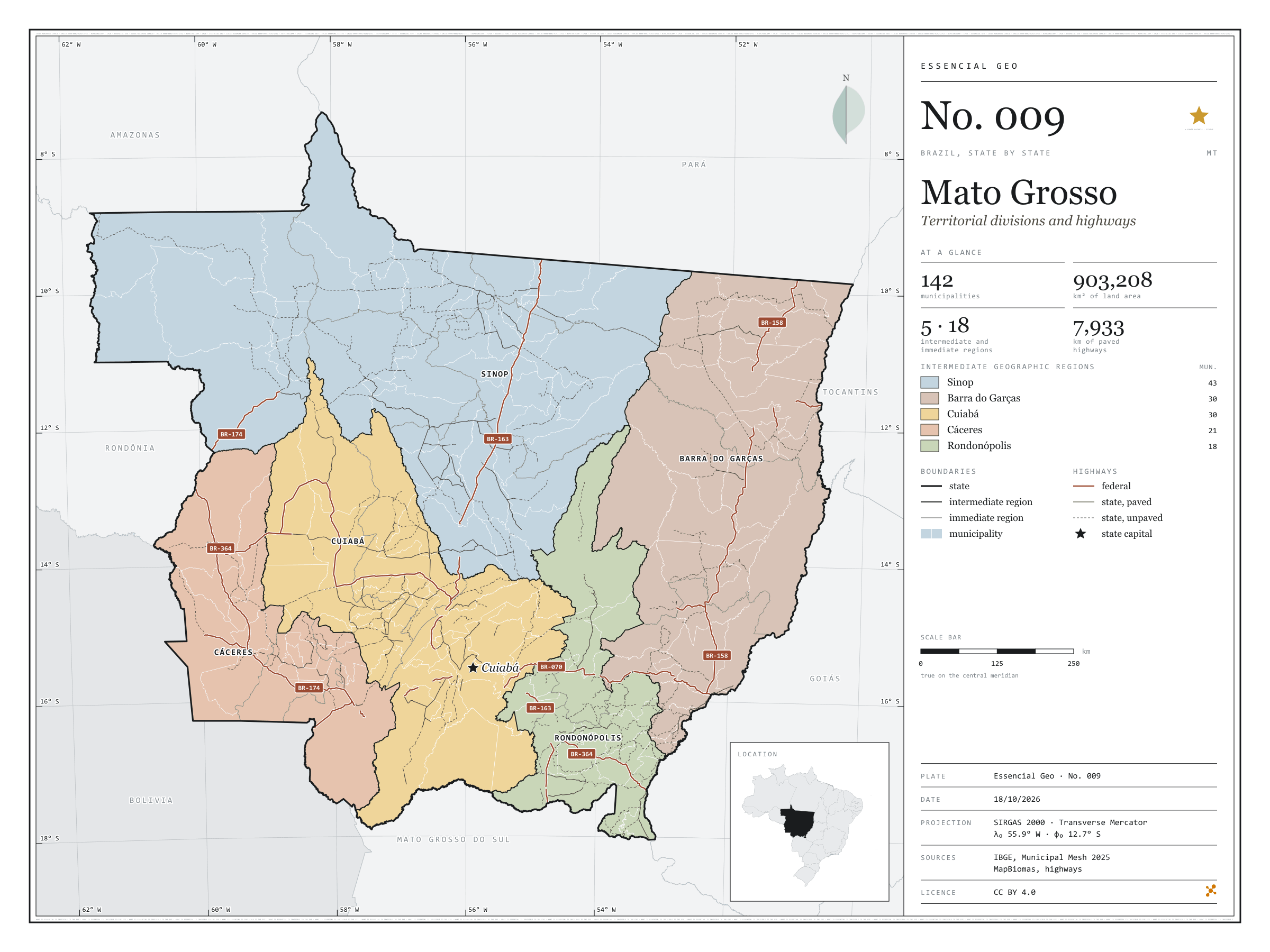
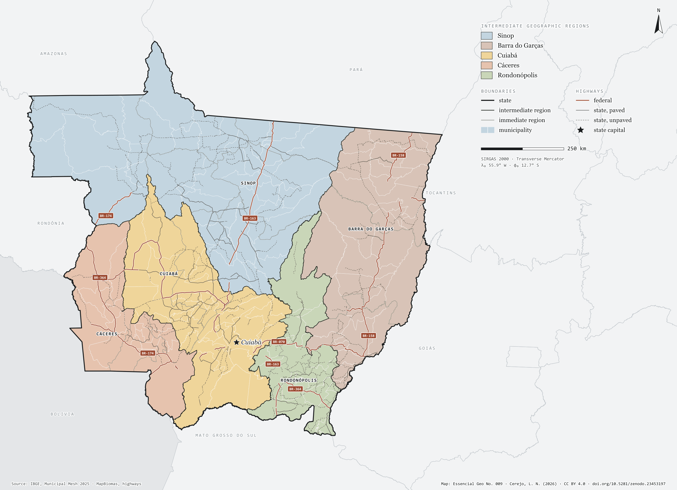
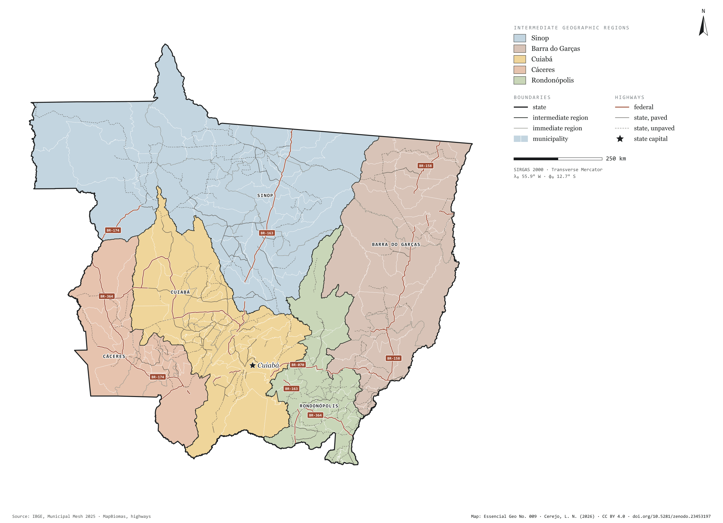
Fig. 009Mato Grosso state (MT)EPSG:4674Source: IBGE, MapBiomas, Natural Earth
Mato Grosso has 142 municipalities across 903,000 km², 10.6 per cent of Brazil. IBGE groups them into 18 immediate regions, drawn around the towns that supply jobs, trade and services to their surroundings, and into 5 intermediate regions that tie those networks together. Sinop is the intermediate region with the most municipalities (43); Rondonópolis, the one with the fewest (18). The largest municipality is Colniza (27,960 km²); the smallest, São Pedro da Cipa (344 km²). Part of the series “Brazil, state by state”: a clean base, with official boundaries and the road network, to start a map without losing the first afternoon gathering files.
Technical record · downloads · citation
At a glance
Municipalities per intermediate region (municipalities)
Sinop43
Barra do Garças30
Cuiabá30
Cáceres21
Rondonópolis18
Area
903,208km²
Largest municipality: Colniza (27,960 km²); smallest: São Pedro da Cipa (344 km²)
Paved highways
7,933km
3,893 km federal and 15,684 km state highways, paved or not
Layers
municipiospolygon142 municipalities, with IBGE code, regions, urban concentration and area (km²)
regioes_intermediariaspolygon5 intermediate geographic regions
regioes_imediataspolygon18 immediate geographic regions
limite_estadualpolygonBoundary of the federative unit
rodoviaslineFederal and state highways: route number, surface, physical status, carriageways
capitalpointIndicative point for the capital (not the exact seat)
The map without a frame, with legend, scale, reference system and credit written on it: ready for papers, lectures and slides. In two versions: with the basemap (neighbours and sea) or only the mapped area, on white.
CEREJO, Lucas Nakamura. Mato Grosso: divisão territorial e rodovias. Versão 1.0.0. [S. l.]: Zenodo, 2026. Conjunto de dados. DOI: 10.5281/zenodo.23453197. Disponível em: https://doi.org/10.5281/zenodo.23453197. Acesso em: 10 nov. 2026.
Cerejo, L. N. (2026). Mato Grosso: divisão territorial e rodovias [Mato Grosso: Territorial divisions and highways] (Version 1.0.0) [Data set]. Zenodo. https://doi.org/10.5281/zenodo.23453197
@dataset{cerejo2026_estado_mato_grosso,
  author    = {Cerejo, Lucas Nakamura},
  title     = {Mato Grosso: Divisão territorial e rodovias},
  year      = {2026},
  publisher = {Zenodo},
  version   = {1.0.0},
  doi       = {10.5281/zenodo.23453197},
  url       = {https://doi.org/10.5281/zenodo.23453197},
  language  = {portuguese},
  note      = {English title: Mato Grosso: Territorial divisions and highways. Licence CC BY 4.0}
}
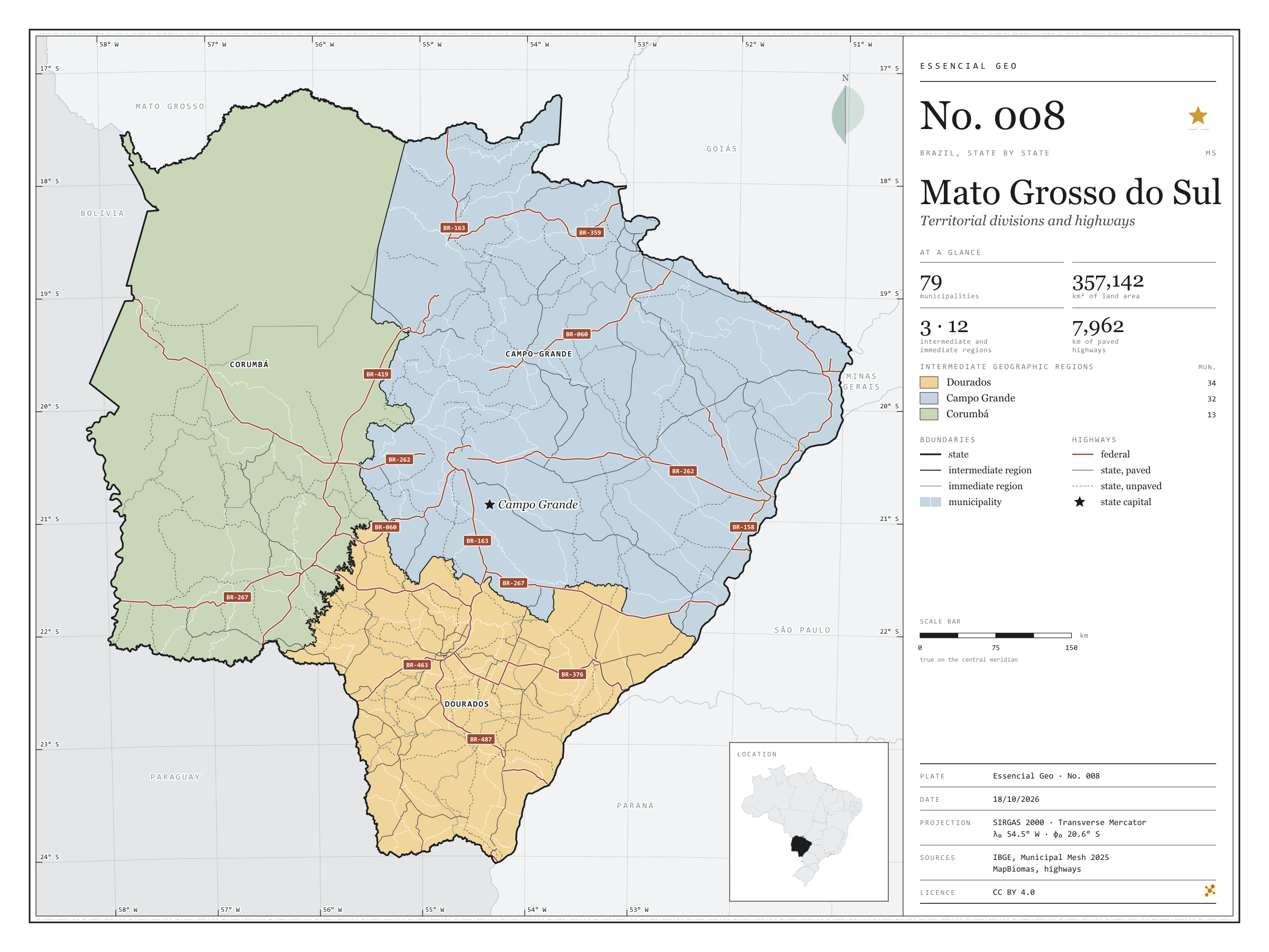
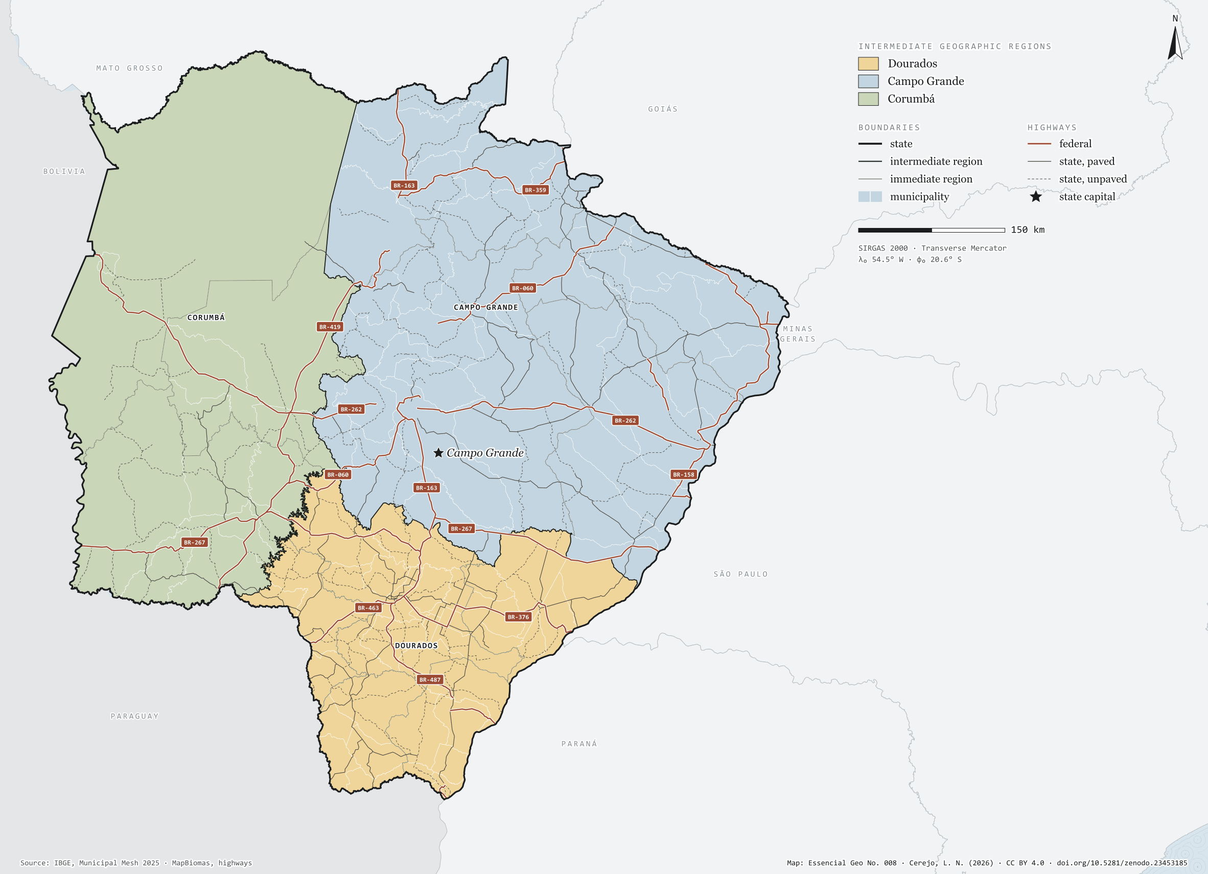
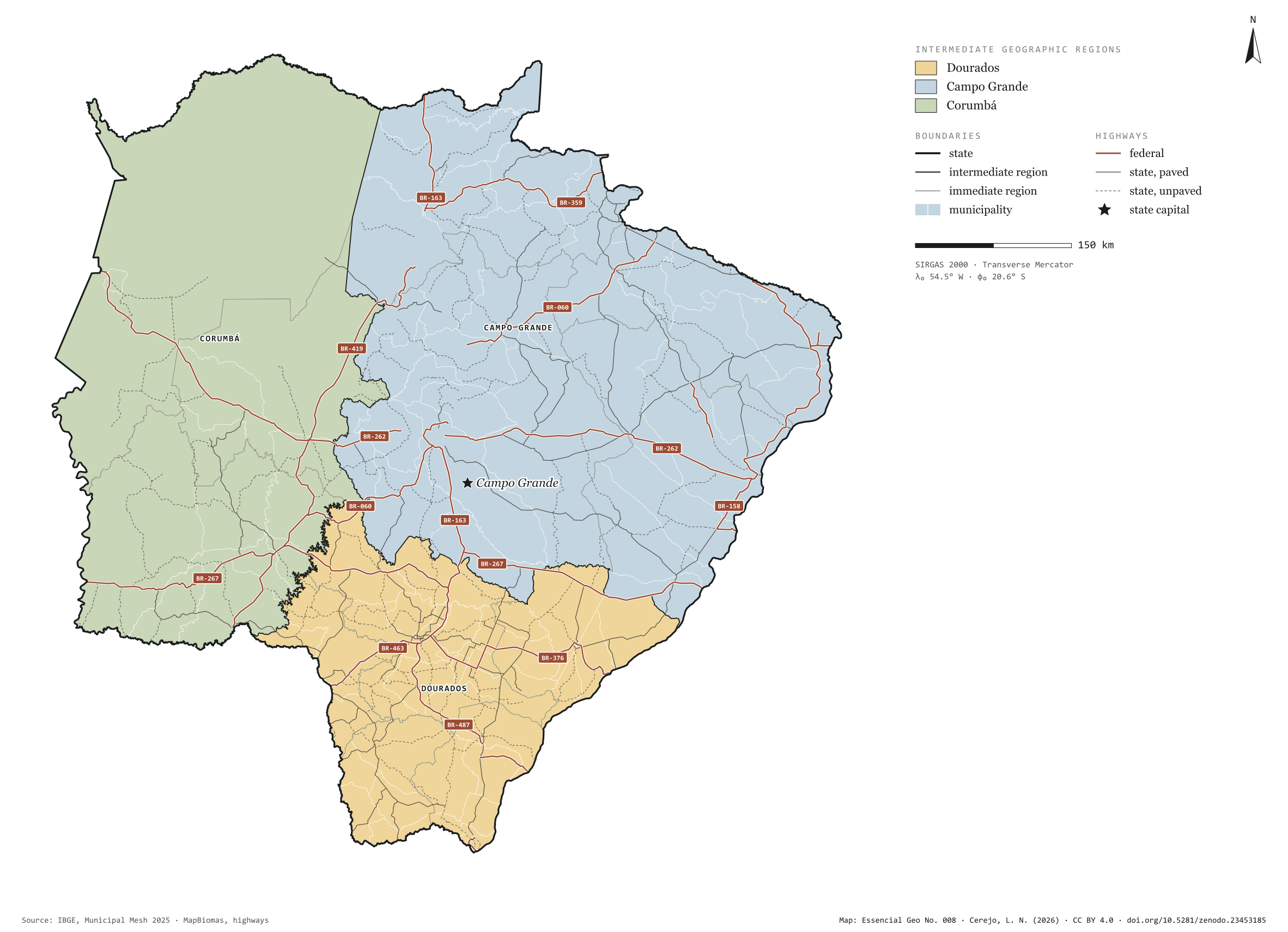
Fig. 008Mato Grosso do Sul state (MS)EPSG:4674Source: IBGE, MapBiomas, Natural Earth
Mato Grosso do Sul has 79 municipalities across 357,000 km², 4.2 per cent of Brazil. IBGE groups them into 12 immediate regions, drawn around the towns that supply jobs, trade and services to their surroundings, and into 3 intermediate regions that tie those networks together. Dourados is the intermediate region with the most municipalities (34); Corumbá, the one with the fewest (13). The largest municipality is Corumbá (64,431 km²); the smallest, Douradina (280 km²). Part of the series “Brazil, state by state”: a clean base, with official boundaries and the road network, to start a map without losing the first afternoon gathering files.
Technical record · downloads · citation
At a glance
Municipalities per intermediate region (municipalities)
Dourados34
Campo Grande32
Corumbá13
Area
357,142km²
Largest municipality: Corumbá (64,431 km²); smallest: Douradina (280 km²)
Paved highways
7,962km
3,798 km federal and 11,355 km state highways, paved or not
Layers
municipiospolygon79 municipalities, with IBGE code, regions, urban concentration and area (km²)
regioes_intermediariaspolygon3 intermediate geographic regions
regioes_imediataspolygon12 immediate geographic regions
limite_estadualpolygonBoundary of the federative unit
rodoviaslineFederal and state highways: route number, surface, physical status, carriageways
capitalpointIndicative point for the capital (not the exact seat)
The map without a frame, with legend, scale, reference system and credit written on it: ready for papers, lectures and slides. In two versions: with the basemap (neighbours and sea) or only the mapped area, on white.
CEREJO, Lucas Nakamura. Mato Grosso do Sul: divisão territorial e rodovias. Versão 1.0.0. [S. l.]: Zenodo, 2026. Conjunto de dados. DOI: 10.5281/zenodo.23453185. Disponível em: https://doi.org/10.5281/zenodo.23453185. Acesso em: 10 nov. 2026.
Cerejo, L. N. (2026). Mato Grosso do Sul: divisão territorial e rodovias [Mato Grosso do Sul: Territorial divisions and highways] (Version 1.0.0) [Data set]. Zenodo. https://doi.org/10.5281/zenodo.23453185
@dataset{cerejo2026_estado_mato_grosso_do_sul,
  author    = {Cerejo, Lucas Nakamura},
  title     = {Mato Grosso do Sul: Divisão territorial e rodovias},
  year      = {2026},
  publisher = {Zenodo},
  version   = {1.0.0},
  doi       = {10.5281/zenodo.23453185},
  url       = {https://doi.org/10.5281/zenodo.23453185},
  language  = {portuguese},
  note      = {English title: Mato Grosso do Sul: Territorial divisions and highways. Licence CC BY 4.0}
}
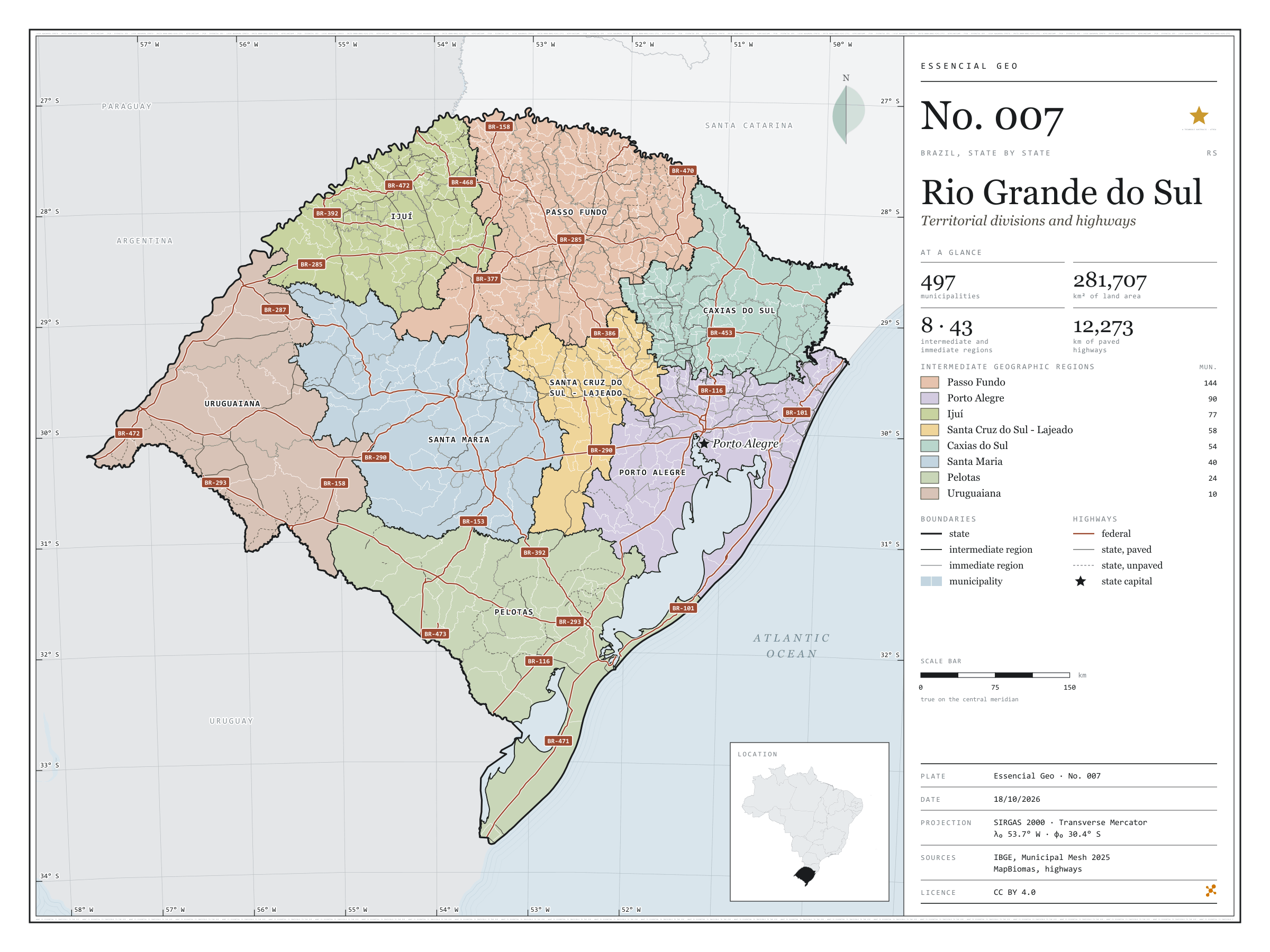
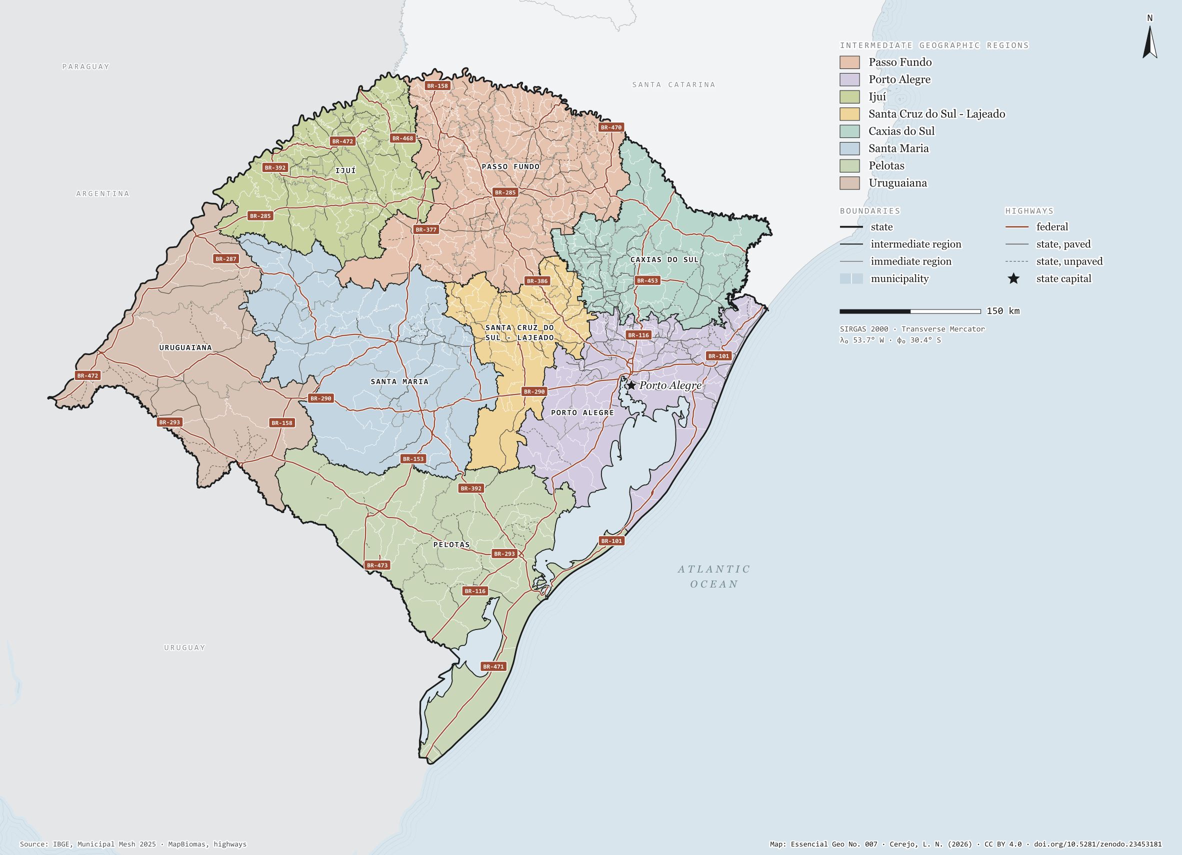
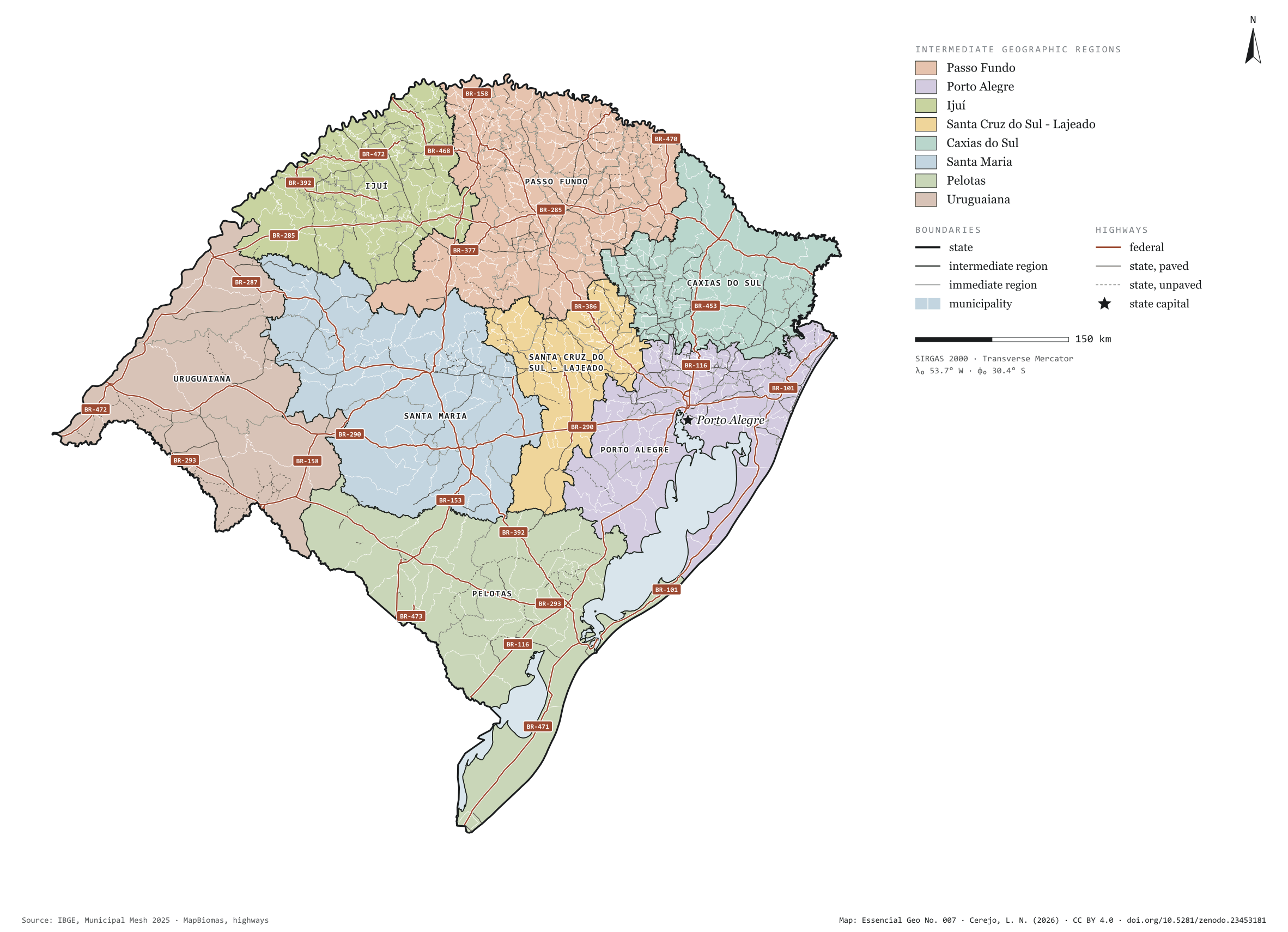
Fig. 007Rio Grande do Sul state (RS)EPSG:4674Source: IBGE, MapBiomas, Natural Earth
Rio Grande do Sul has 497 municipalities across 282,000 km², 3.3 per cent of Brazil. IBGE groups them into 43 immediate regions, drawn around the towns that supply jobs, trade and services to their surroundings, and into 8 intermediate regions that tie those networks together. Passo Fundo is the intermediate region with the most municipalities (144); Uruguaiana, the one with the fewest (10). The largest municipality is Alegrete (7,801 km²); the smallest, Esteio (28 km²). Part of the series “Brazil, state by state”: a clean base, with official boundaries and the road network, to start a map without losing the first afternoon gathering files.
Technical record · downloads · citation
At a glance
Municipalities per intermediate region (municipalities)
Passo Fundo144
Porto Alegre90
Ijuí77
Santa Cruz do Sul - Lajeado58
Caxias do Sul54
Santa Maria40
Pelotas24
Uruguaiana10
Area
281,707km²
Largest municipality: Alegrete (7,801 km²); smallest: Esteio (28 km²)
Paved highways
12,273km
5,906 km federal and 10,026 km state highways, paved or not
Layers
municipiospolygon497 municipalities, with IBGE code, regions, urban concentration and area (km²)
regioes_intermediariaspolygon8 intermediate geographic regions
regioes_imediataspolygon43 immediate geographic regions
limite_estadualpolygonBoundary of the federative unit
rodoviaslineFederal and state highways: route number, surface, physical status, carriageways
capitalpointIndicative point for the capital (not the exact seat)
The map without a frame, with legend, scale, reference system and credit written on it: ready for papers, lectures and slides. In two versions: with the basemap (neighbours and sea) or only the mapped area, on white.
CEREJO, Lucas Nakamura. Rio Grande do Sul: divisão territorial e rodovias. Versão 1.0.0. [S. l.]: Zenodo, 2026. Conjunto de dados. DOI: 10.5281/zenodo.23453181. Disponível em: https://doi.org/10.5281/zenodo.23453181. Acesso em: 10 nov. 2026.
Cerejo, L. N. (2026). Rio Grande do Sul: divisão territorial e rodovias [Rio Grande do Sul: Territorial divisions and highways] (Version 1.0.0) [Data set]. Zenodo. https://doi.org/10.5281/zenodo.23453181
@dataset{cerejo2026_estado_rio_grande_do_sul,
  author    = {Cerejo, Lucas Nakamura},
  title     = {Rio Grande do Sul: Divisão territorial e rodovias},
  year      = {2026},
  publisher = {Zenodo},
  version   = {1.0.0},
  doi       = {10.5281/zenodo.23453181},
  url       = {https://doi.org/10.5281/zenodo.23453181},
  language  = {portuguese},
  note      = {English title: Rio Grande do Sul: Territorial divisions and highways. Licence CC BY 4.0}
}
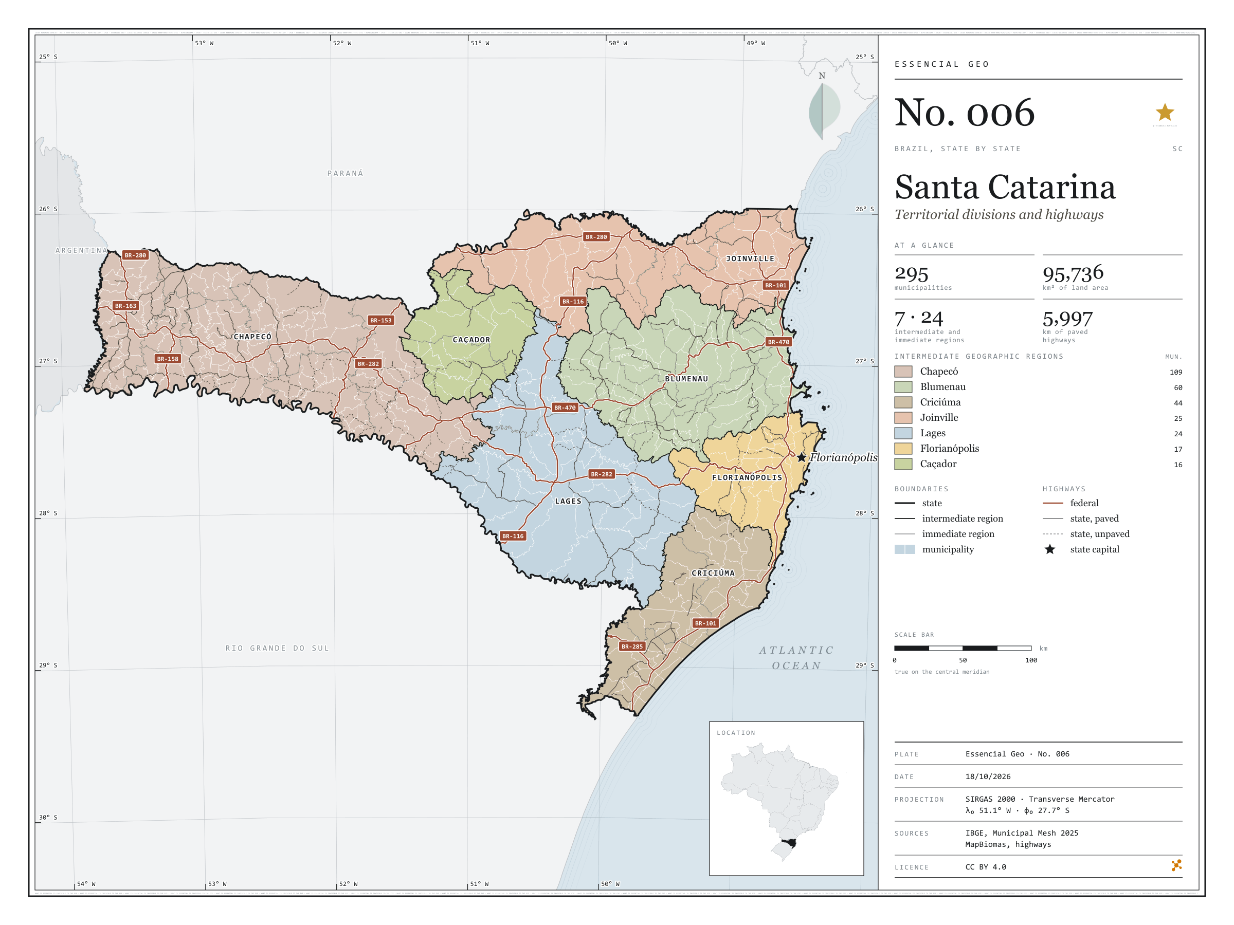
Fig. 006Santa Catarina state (SC)EPSG:4674Source: IBGE, MapBiomas, Natural Earth
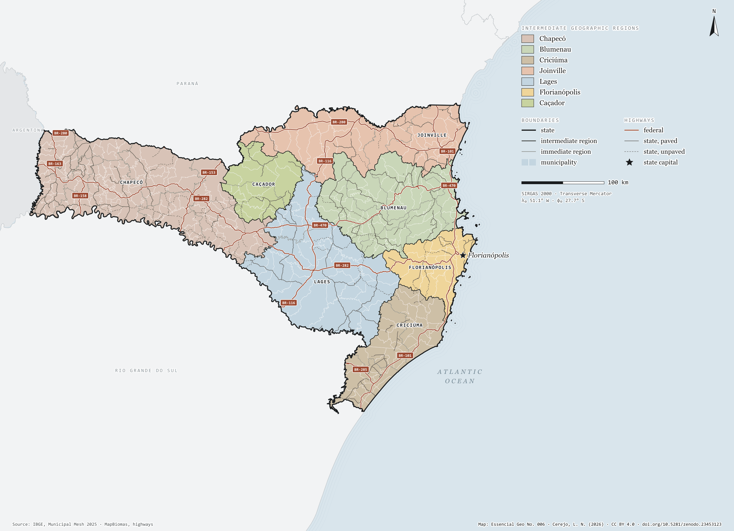
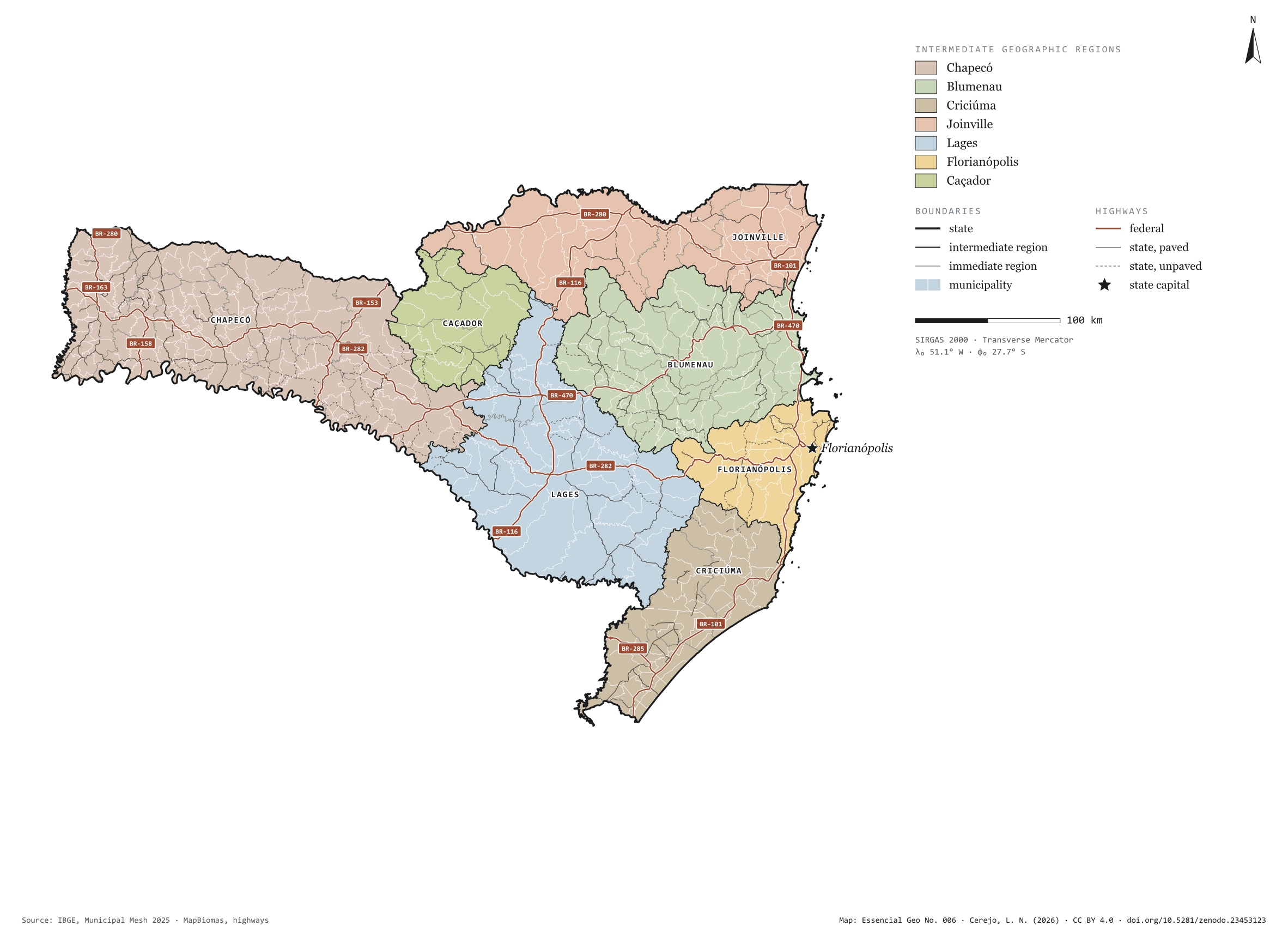
Santa Catarina has 295 municipalities across 96,000 km², 1.1 per cent of Brazil. IBGE groups them into 24 immediate regions, drawn around the towns that supply jobs, trade and services to their surroundings, and into 7 intermediate regions that tie those networks together. Chapecó is the intermediate region with the most municipalities (109); Caçador, the one with the fewest (16). The largest municipality is Lages (2,638 km²); the smallest, Bombinhas (35 km²). Part of the series “Brazil, state by state”: a clean base, with official boundaries and the road network, to start a map without losing the first afternoon gathering files.
Technical record · downloads · citation
At a glance
Municipalities per intermediate region (municipalities)
Chapecó109
Blumenau60
Criciúma44
Joinville25
Lages24
Florianópolis17
Caçador16
Area
95,736km²
Largest municipality: Lages (2,638 km²); smallest: Bombinhas (35 km²)
Paved highways
5,997km
2,444 km federal and 5,271 km state highways, paved or not
Layers
municipiospolygon295 municipalities, with IBGE code, regions, urban concentration and area (km²)
regioes_intermediariaspolygon7 intermediate geographic regions
regioes_imediataspolygon24 immediate geographic regions
limite_estadualpolygonBoundary of the federative unit
rodoviaslineFederal and state highways: route number, surface, physical status, carriageways
capitalpointIndicative point for the capital (not the exact seat)
The map without a frame, with legend, scale, reference system and credit written on it: ready for papers, lectures and slides. In two versions: with the basemap (neighbours and sea) or only the mapped area, on white.
CEREJO, Lucas Nakamura. Santa Catarina: divisão territorial e rodovias. Versão 1.0.0. [S. l.]: Zenodo, 2026. Conjunto de dados. DOI: 10.5281/zenodo.23453123. Disponível em: https://doi.org/10.5281/zenodo.23453123. Acesso em: 10 nov. 2026.
Cerejo, L. N. (2026). Santa Catarina: divisão territorial e rodovias [Santa Catarina: Territorial divisions and highways] (Version 1.0.0) [Data set]. Zenodo. https://doi.org/10.5281/zenodo.23453123
@dataset{cerejo2026_estado_santa_catarina,
  author    = {Cerejo, Lucas Nakamura},
  title     = {Santa Catarina: Divisão territorial e rodovias},
  year      = {2026},
  publisher = {Zenodo},
  version   = {1.0.0},
  doi       = {10.5281/zenodo.23453123},
  url       = {https://doi.org/10.5281/zenodo.23453123},
  language  = {portuguese},
  note      = {English title: Santa Catarina: Territorial divisions and highways. Licence CC BY 4.0}
}
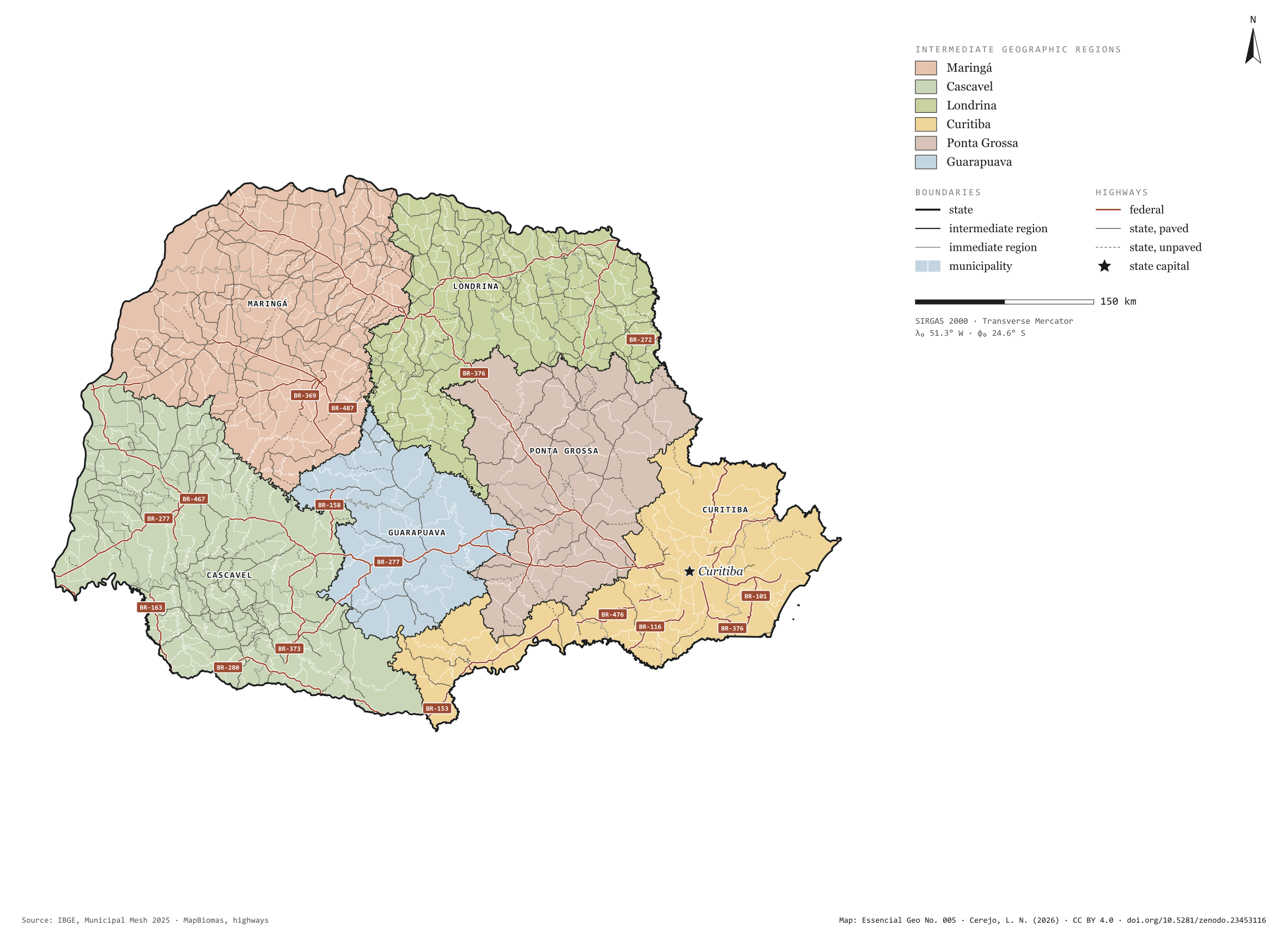
Fig. 005Paraná state (PR)EPSG:4674Source: IBGE, MapBiomas, Natural Earth
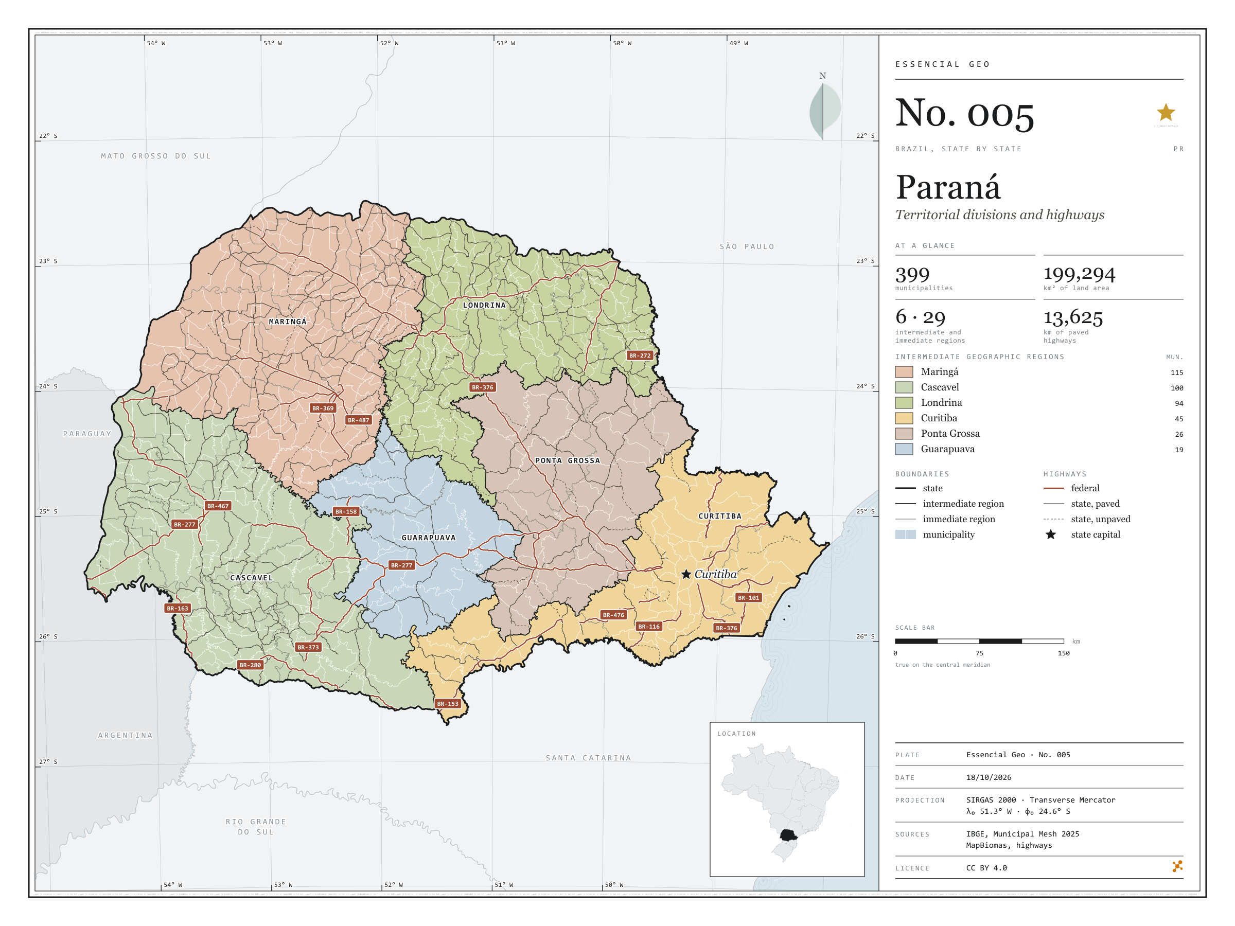
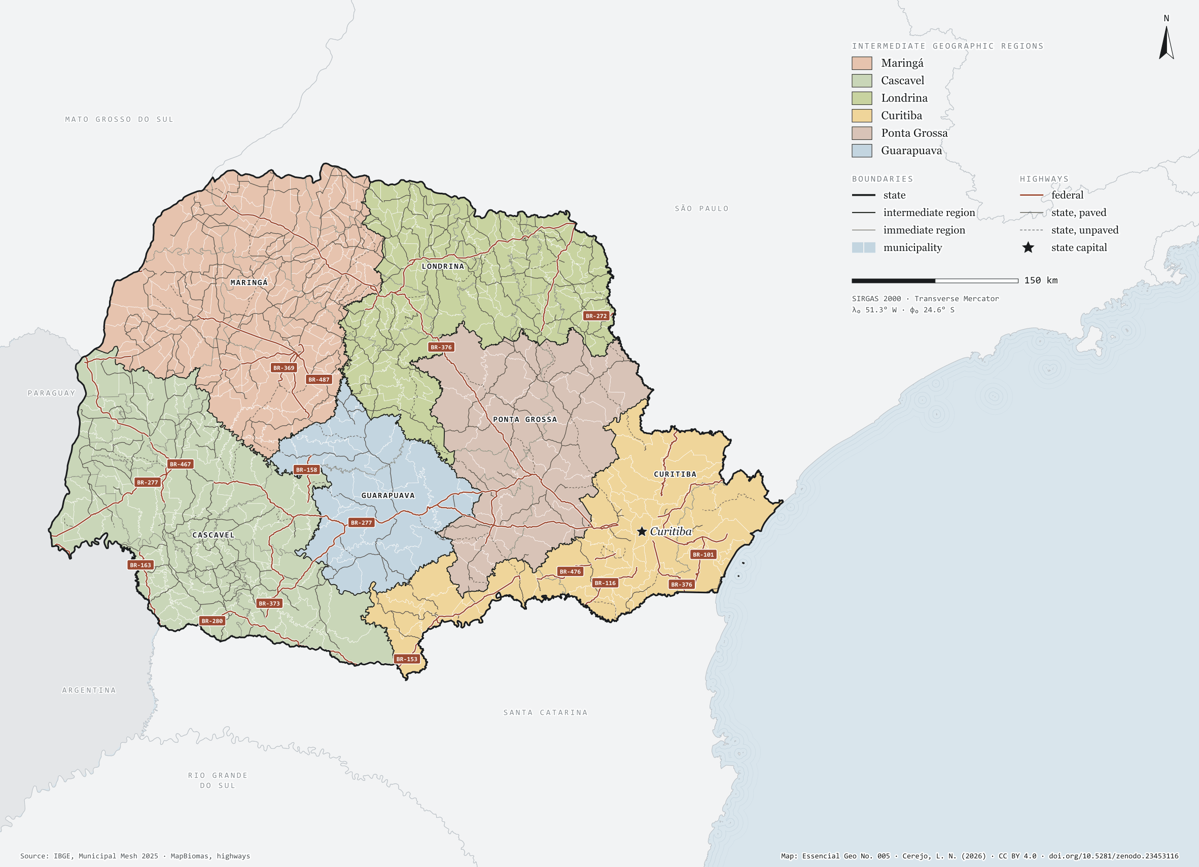
Paraná has 399 municipalities across 199,000 km², 2.3 per cent of Brazil. IBGE groups them into 29 immediate regions, drawn around the towns that supply jobs, trade and services to their surroundings, and into 6 intermediate regions that tie those networks together. Maringá is the intermediate region with the most municipalities (115); Guarapuava, the one with the fewest (19). The largest municipality is Guarapuava (3,164 km²); the smallest, Pinhais (61 km²). Part of the series “Brazil, state by state”: a clean base, with official boundaries and the road network, to start a map without losing the first afternoon gathering files.
Technical record · downloads · citation
At a glance
Municipalities per intermediate region (municipalities)
Maringá115
Cascavel100
Londrina94
Curitiba45
Ponta Grossa26
Guarapuava19
Area
199,294km²
Largest municipality: Guarapuava (3,164 km²); smallest: Pinhais (61 km²)
Paved highways
13,625km
3,513 km federal and 12,122 km state highways, paved or not
Layers
municipiospolygon399 municipalities, with IBGE code, regions, urban concentration and area (km²)
regioes_intermediariaspolygon6 intermediate geographic regions
regioes_imediataspolygon29 immediate geographic regions
limite_estadualpolygonBoundary of the federative unit
rodoviaslineFederal and state highways: route number, surface, physical status, carriageways
capitalpointIndicative point for the capital (not the exact seat)
The map without a frame, with legend, scale, reference system and credit written on it: ready for papers, lectures and slides. In two versions: with the basemap (neighbours and sea) or only the mapped area, on white.
CEREJO, Lucas Nakamura. Paraná: divisão territorial e rodovias. Versão 1.0.0. [S. l.]: Zenodo, 2026. Conjunto de dados. DOI: 10.5281/zenodo.23453116. Disponível em: https://doi.org/10.5281/zenodo.23453116. Acesso em: 10 nov. 2026.
Cerejo, L. N. (2026). Paraná: divisão territorial e rodovias [Paraná: Territorial divisions and highways] (Version 1.0.0) [Data set]. Zenodo. https://doi.org/10.5281/zenodo.23453116
@dataset{cerejo2026_estado_parana,
  author    = {Cerejo, Lucas Nakamura},
  title     = {Paraná: Divisão territorial e rodovias},
  year      = {2026},
  publisher = {Zenodo},
  version   = {1.0.0},
  doi       = {10.5281/zenodo.23453116},
  url       = {https://doi.org/10.5281/zenodo.23453116},
  language  = {portuguese},
  note      = {English title: Paraná: Territorial divisions and highways. Licence CC BY 4.0}
}
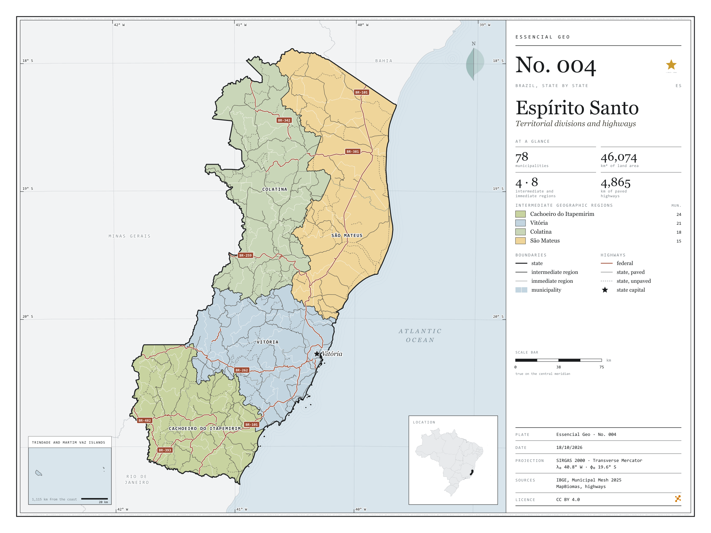
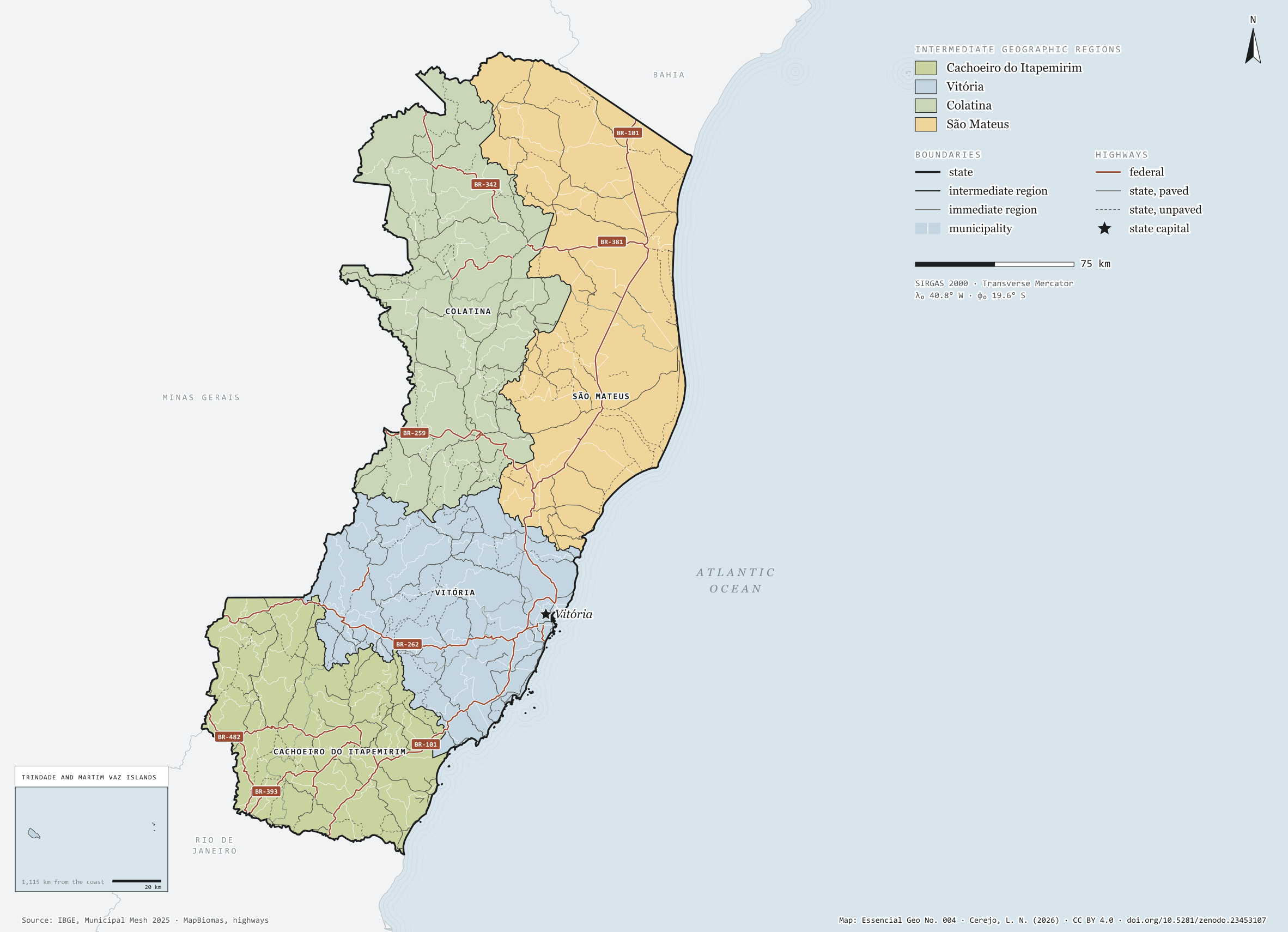
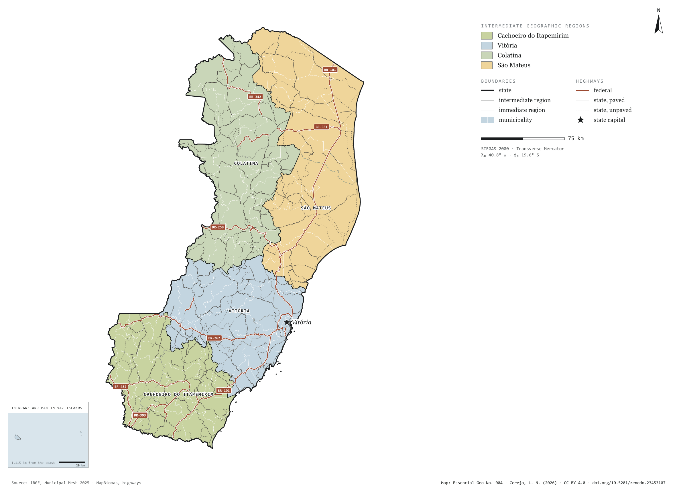
Fig. 004Espírito Santo state (ES)EPSG:4674Source: IBGE, MapBiomas, Natural Earth
Espírito Santo has 78 municipalities across 46,000 km², 0.5 per cent of Brazil. IBGE groups them into 8 immediate regions, drawn around the towns that supply jobs, trade and services to their surroundings, and into 4 intermediate regions that tie those networks together. Cachoeiro do Itapemirim is the intermediate region with the most municipalities (24); São Mateus, the one with the fewest (15). The largest municipality is Linhares (3,496 km²); the smallest, Piúma (74 km²). Part of the series “Brazil, state by state”: a clean base, with official boundaries and the road network, to start a map without losing the first afternoon gathering files.
Technical record · downloads · citation
At a glance
Municipalities per intermediate region (municipalities)
Cachoeiro do Itapemirim24
Vitória21
Colatina18
São Mateus15
Area
46,074km²
Largest municipality: Linhares (3,496 km²); smallest: Piúma (74 km²)
Paved highways
4,865km
1,241 km federal and 5,731 km state highways, paved or not
Layers
municipiospolygon78 municipalities, with IBGE code, regions, urban concentration and area (km²)
regioes_intermediariaspolygon4 intermediate geographic regions
regioes_imediataspolygon8 immediate geographic regions
limite_estadualpolygonBoundary of the federative unit
rodoviaslineFederal and state highways: route number, surface, physical status, carriageways
capitalpointIndicative point for the capital (not the exact seat)
The map without a frame, with legend, scale, reference system and credit written on it: ready for papers, lectures and slides. In two versions: with the basemap (neighbours and sea) or only the mapped area, on white.
CEREJO, Lucas Nakamura. Espírito Santo: divisão territorial e rodovias. Versão 1.0.0. [S. l.]: Zenodo, 2026. Conjunto de dados. DOI: 10.5281/zenodo.23453107. Disponível em: https://doi.org/10.5281/zenodo.23453107. Acesso em: 10 nov. 2026.
Cerejo, L. N. (2026). Espírito Santo: divisão territorial e rodovias [Espírito Santo: Territorial divisions and highways] (Version 1.0.0) [Data set]. Zenodo. https://doi.org/10.5281/zenodo.23453107
@dataset{cerejo2026_estado_espirito_santo,
  author    = {Cerejo, Lucas Nakamura},
  title     = {Espírito Santo: Divisão territorial e rodovias},
  year      = {2026},
  publisher = {Zenodo},
  version   = {1.0.0},
  doi       = {10.5281/zenodo.23453107},
  url       = {https://doi.org/10.5281/zenodo.23453107},
  language  = {portuguese},
  note      = {English title: Espírito Santo: Territorial divisions and highways. Licence CC BY 4.0}
}
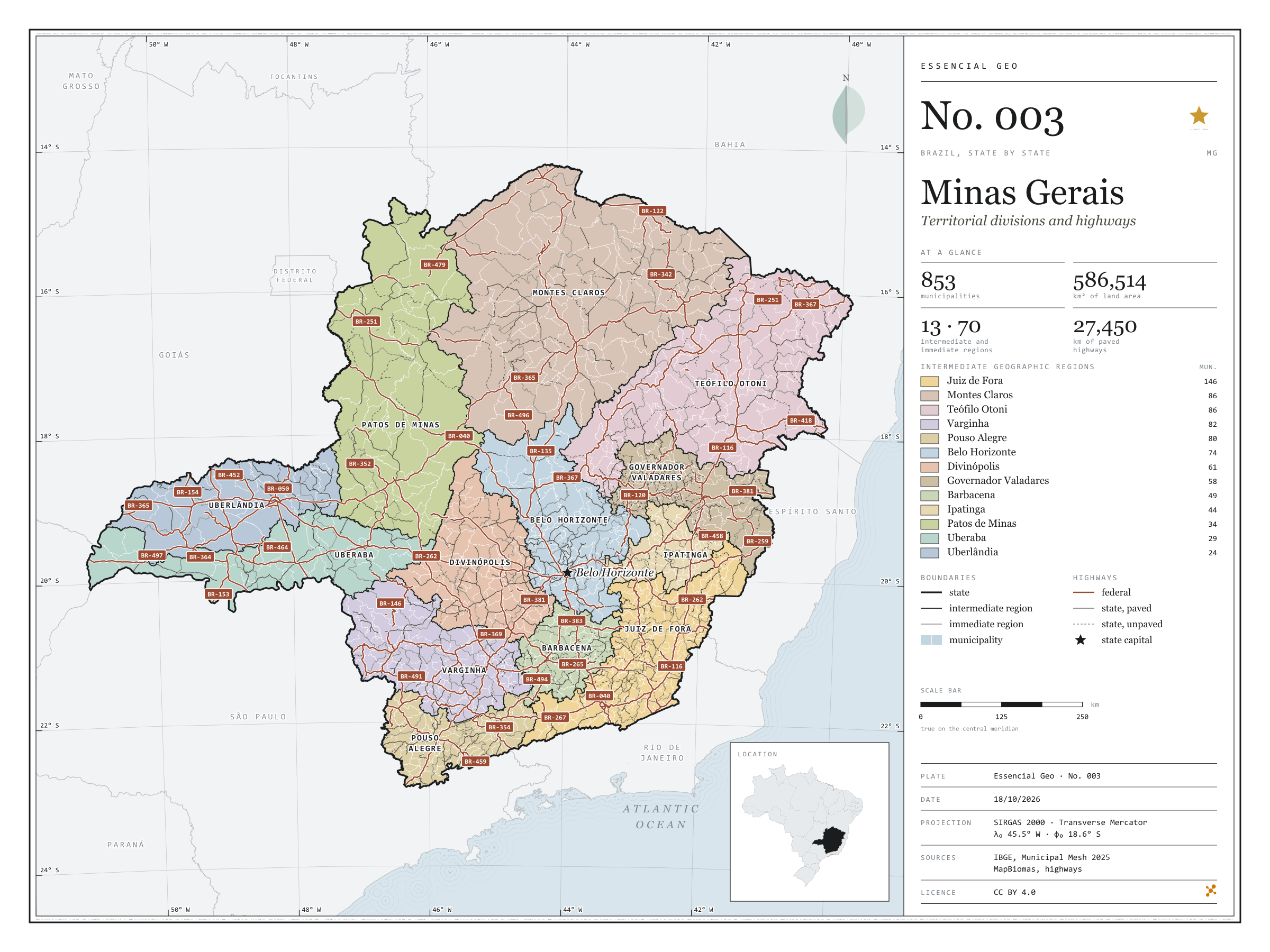
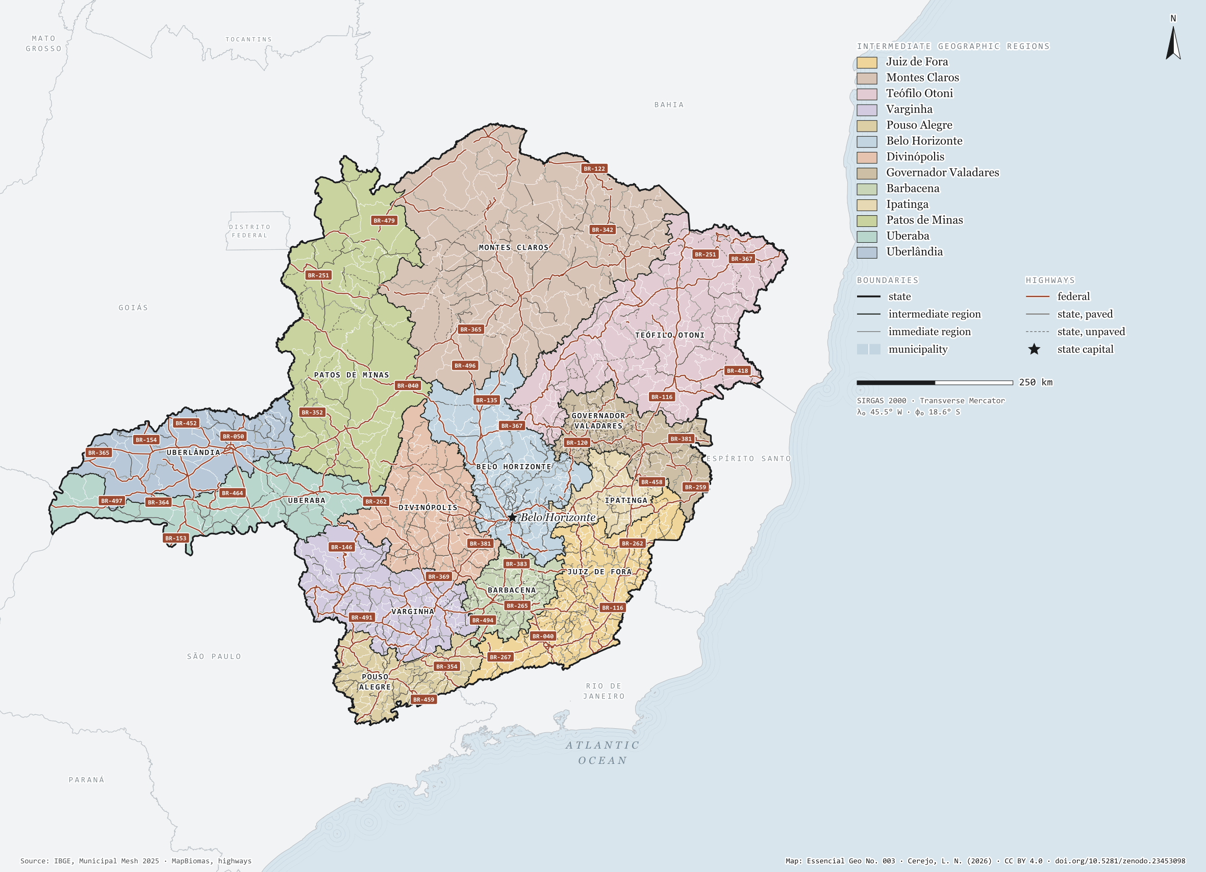
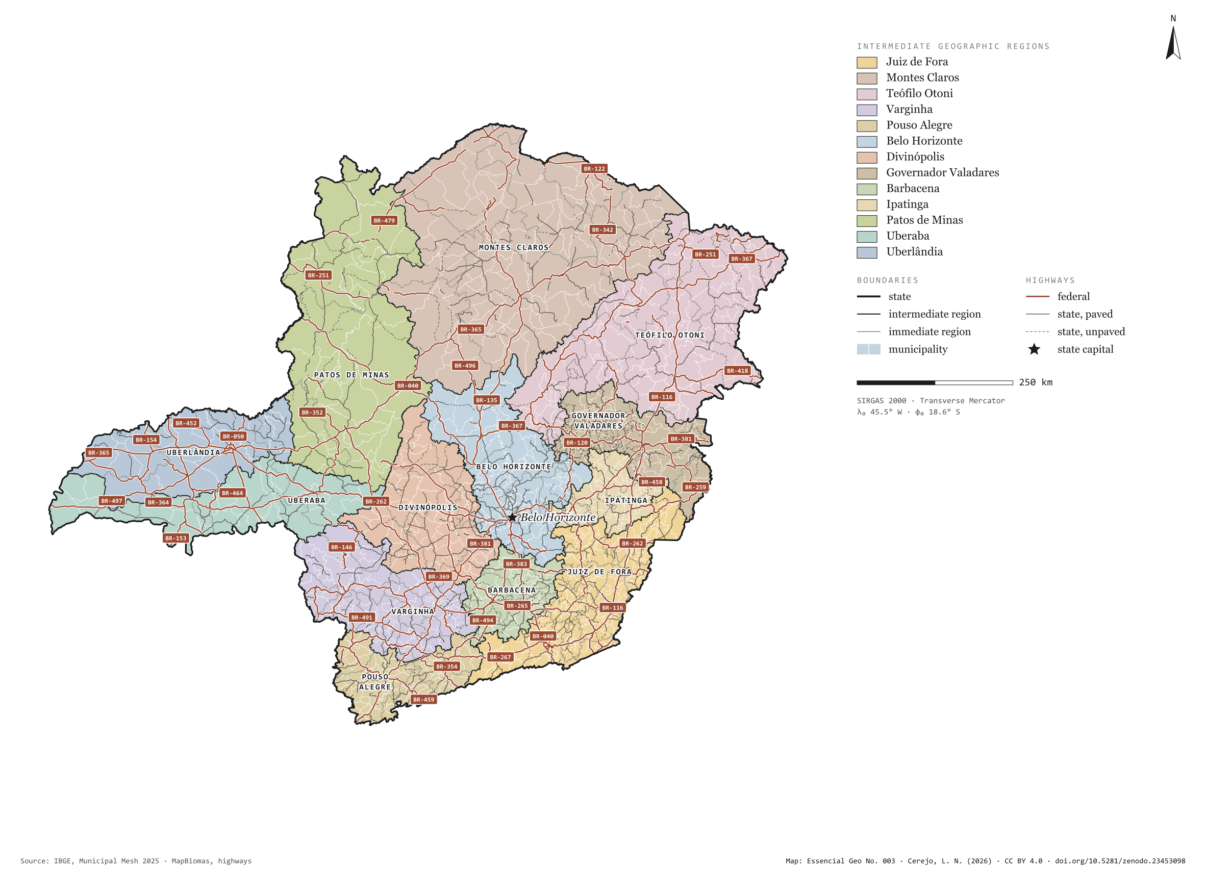
Fig. 003Minas Gerais state (MG)EPSG:4674Source: IBGE, MapBiomas, Natural Earth
Minas Gerais has 853 municipalities across 587,000 km², 6.9 per cent of Brazil. IBGE groups them into 70 immediate regions, drawn around the towns that supply jobs, trade and services to their surroundings, and into 13 intermediate regions that tie those networks together. Juiz de Fora is the intermediate region with the most municipalities (146); Uberlândia, the one with the fewest (24). The largest municipality is João Pinheiro (10,727 km²); the smallest, Santa Cruz de Minas (3.6 km²). Part of the series “Brazil, state by state”: a clean base, with official boundaries and the road network, to start a map without losing the first afternoon gathering files.
Technical record · downloads · citation
At a glance
Municipalities per intermediate region (municipalities)
Juiz de Fora146
Montes Claros86
Teófilo Otoni86
Varginha82
Pouso Alegre80
Belo Horizonte74
Divinópolis61
Governador Valadares58
Barbacena49
Ipatinga44
Patos de Minas34
Uberaba29
Uberlândia24
Area
586,514km²
Largest municipality: João Pinheiro (10,727 km²); smallest: Santa Cruz de Minas (3.6 km²)
Paved highways
27,450km
14,980 km federal and 20,772 km state highways, paved or not
Layers
municipiospolygon853 municipalities, with IBGE code, regions, urban concentration and area (km²)
regioes_intermediariaspolygon13 intermediate geographic regions
regioes_imediataspolygon70 immediate geographic regions
limite_estadualpolygonBoundary of the federative unit
rodoviaslineFederal and state highways: route number, surface, physical status, carriageways
capitalpointIndicative point for the capital (not the exact seat)
The map without a frame, with legend, scale, reference system and credit written on it: ready for papers, lectures and slides. In two versions: with the basemap (neighbours and sea) or only the mapped area, on white.
CEREJO, Lucas Nakamura. Minas Gerais: divisão territorial e rodovias. Versão 1.0.0. [S. l.]: Zenodo, 2026. Conjunto de dados. DOI: 10.5281/zenodo.23453098. Disponível em: https://doi.org/10.5281/zenodo.23453098. Acesso em: 10 nov. 2026.
Cerejo, L. N. (2026). Minas Gerais: divisão territorial e rodovias [Minas Gerais: Territorial divisions and highways] (Version 1.0.0) [Data set]. Zenodo. https://doi.org/10.5281/zenodo.23453098
@dataset{cerejo2026_estado_minas_gerais,
  author    = {Cerejo, Lucas Nakamura},
  title     = {Minas Gerais: Divisão territorial e rodovias},
  year      = {2026},
  publisher = {Zenodo},
  version   = {1.0.0},
  doi       = {10.5281/zenodo.23453098},
  url       = {https://doi.org/10.5281/zenodo.23453098},
  language  = {portuguese},
  note      = {English title: Minas Gerais: Territorial divisions and highways. Licence CC BY 4.0}
}
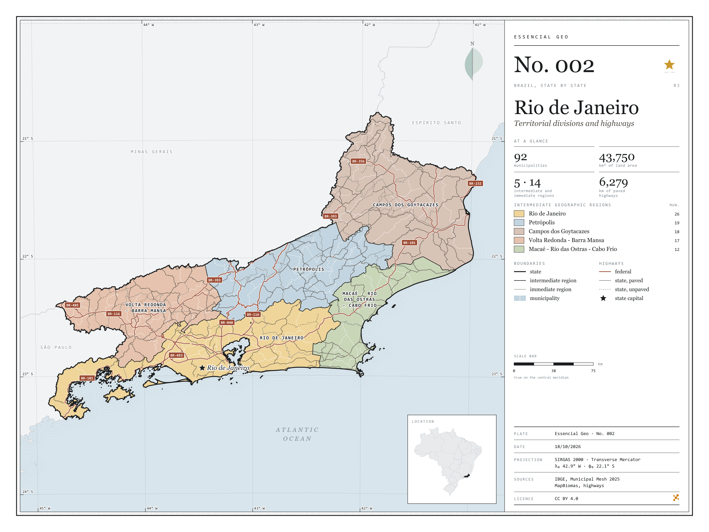
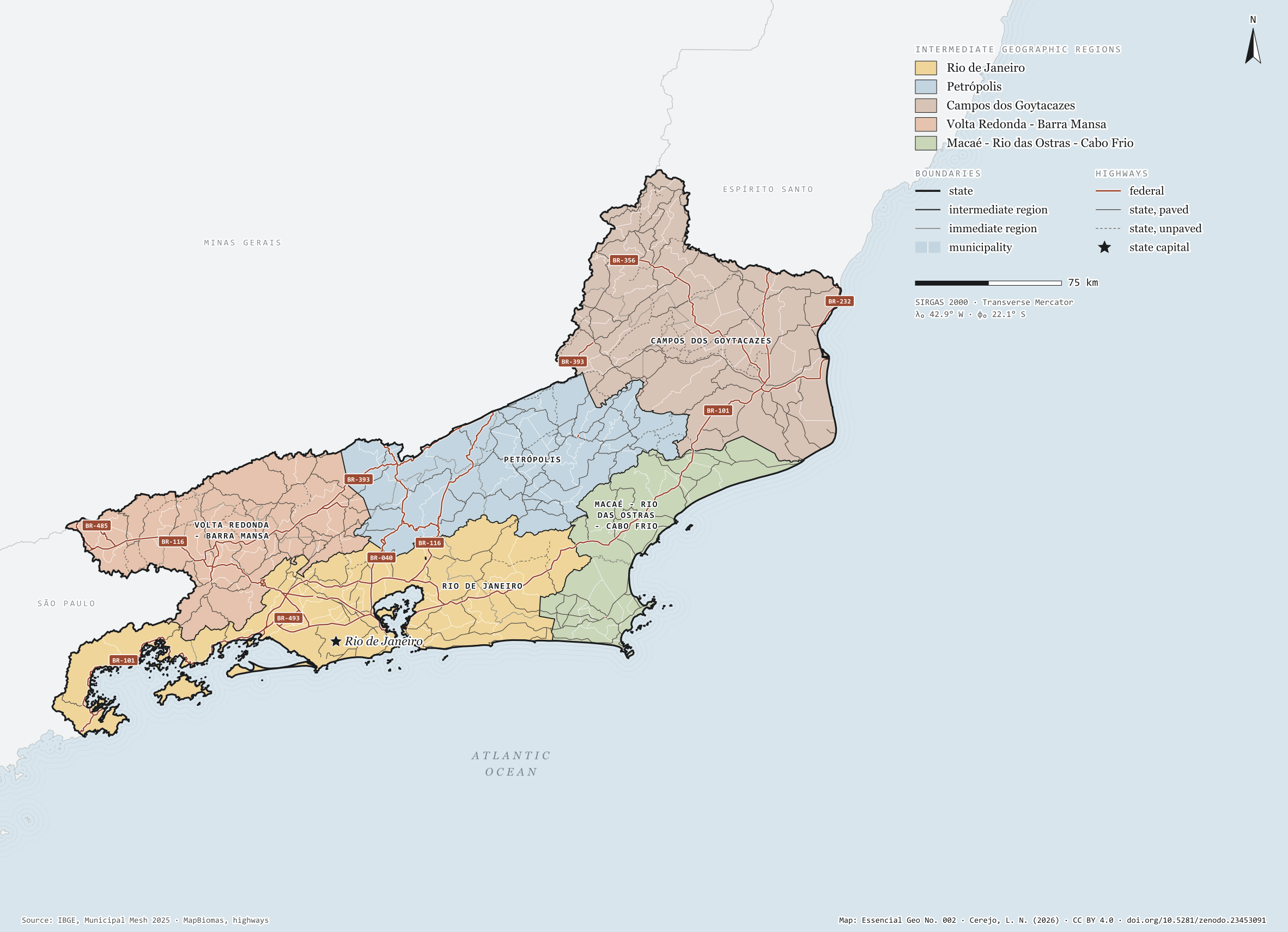
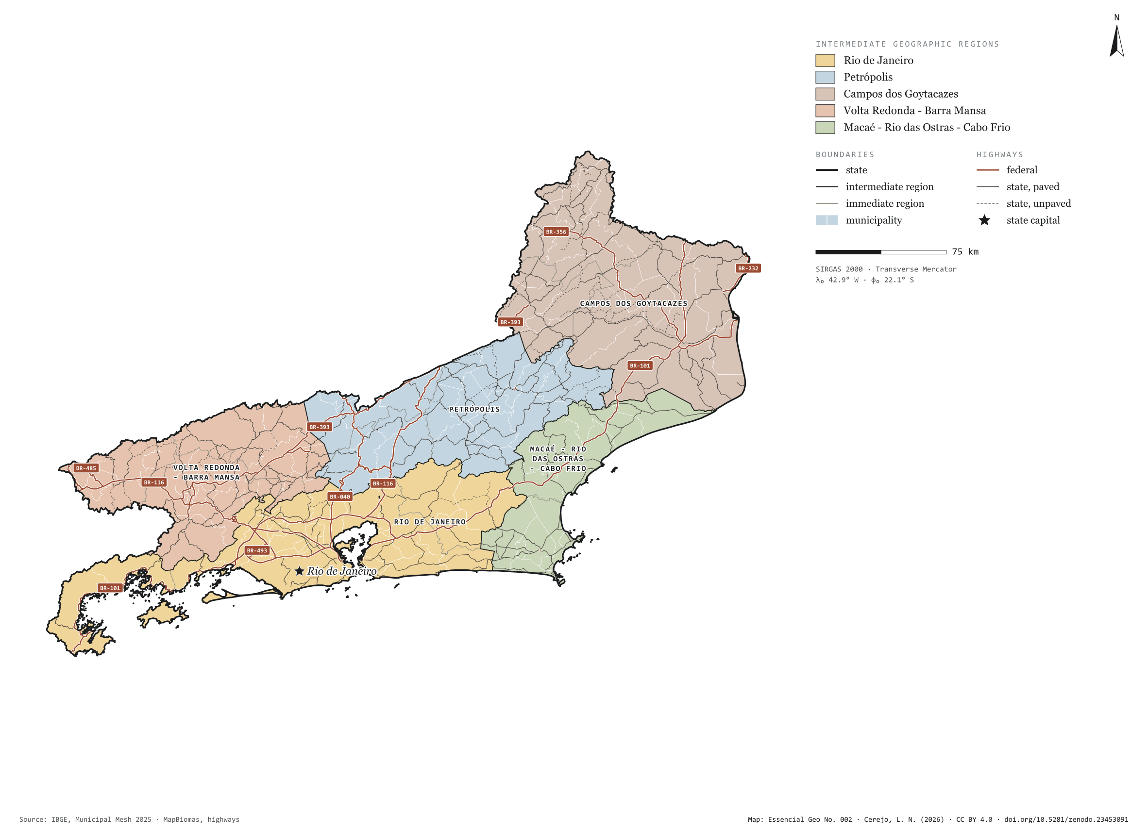
Fig. 002Rio de Janeiro state (RJ)EPSG:4674Source: IBGE, MapBiomas, Natural Earth
Rio de Janeiro has 92 municipalities across 44,000 km², 0.5 per cent of Brazil. IBGE groups them into 14 immediate regions, drawn around the towns that supply jobs, trade and services to their surroundings, and into 5 intermediate regions that tie those networks together. Rio de Janeiro is the intermediate region with the most municipalities (26); Macaé - Rio das Ostras - Cabo Frio, the one with the fewest (12). The largest municipality is Campos dos Goytacazes (4,033 km²); the smallest, Nilópolis (19 km²). Part of the series “Brazil, state by state”: a clean base, with official boundaries and the road network, to start a map without losing the first afternoon gathering files.
Technical record · downloads · citation
At a glance
Municipalities per intermediate region (municipalities)
Rio de Janeiro26
Petrópolis19
Campos dos Goytacazes18
Volta Redonda - Barra Mansa17
Macaé - Rio das Ostras - Cabo Frio12
Area
43,750km²
Largest municipality: Campos dos Goytacazes (4,033 km²); smallest: Nilópolis (19 km²)
Paved highways
6,279km
1,739 km federal and 5,469 km state highways, paved or not
Layers
municipiospolygon92 municipalities, with IBGE code, regions, urban concentration and area (km²)
regioes_intermediariaspolygon5 intermediate geographic regions
regioes_imediataspolygon14 immediate geographic regions
limite_estadualpolygonBoundary of the federative unit
rodoviaslineFederal and state highways: route number, surface, physical status, carriageways
capitalpointIndicative point for the capital (not the exact seat)
The map without a frame, with legend, scale, reference system and credit written on it: ready for papers, lectures and slides. In two versions: with the basemap (neighbours and sea) or only the mapped area, on white.
CEREJO, Lucas Nakamura. Rio de Janeiro: divisão territorial e rodovias. Versão 1.0.0. [S. l.]: Zenodo, 2026. Conjunto de dados. DOI: 10.5281/zenodo.23453091. Disponível em: https://doi.org/10.5281/zenodo.23453091. Acesso em: 10 nov. 2026.
Cerejo, L. N. (2026). Rio de Janeiro: divisão territorial e rodovias [Rio de Janeiro: Territorial divisions and highways] (Version 1.0.0) [Data set]. Zenodo. https://doi.org/10.5281/zenodo.23453091
@dataset{cerejo2026_estado_rio_de_janeiro,
  author    = {Cerejo, Lucas Nakamura},
  title     = {Rio de Janeiro: Divisão territorial e rodovias},
  year      = {2026},
  publisher = {Zenodo},
  version   = {1.0.0},
  doi       = {10.5281/zenodo.23453091},
  url       = {https://doi.org/10.5281/zenodo.23453091},
  language  = {portuguese},
  note      = {English title: Rio de Janeiro: Territorial divisions and highways. Licence CC BY 4.0}
}
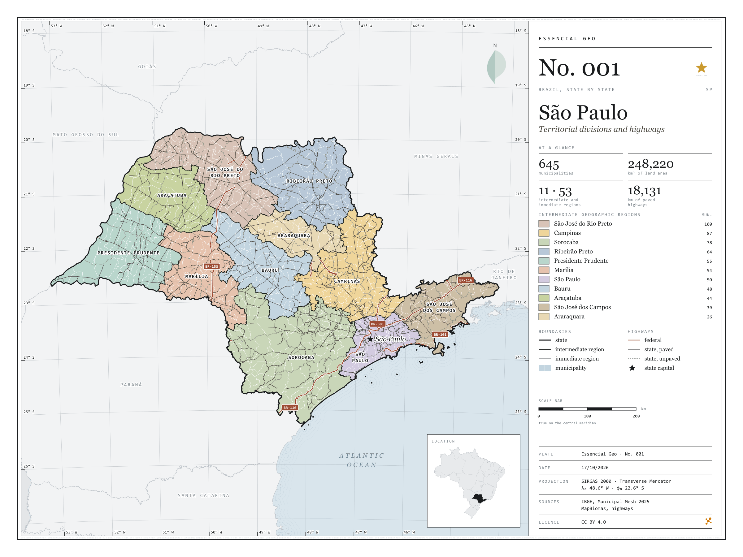
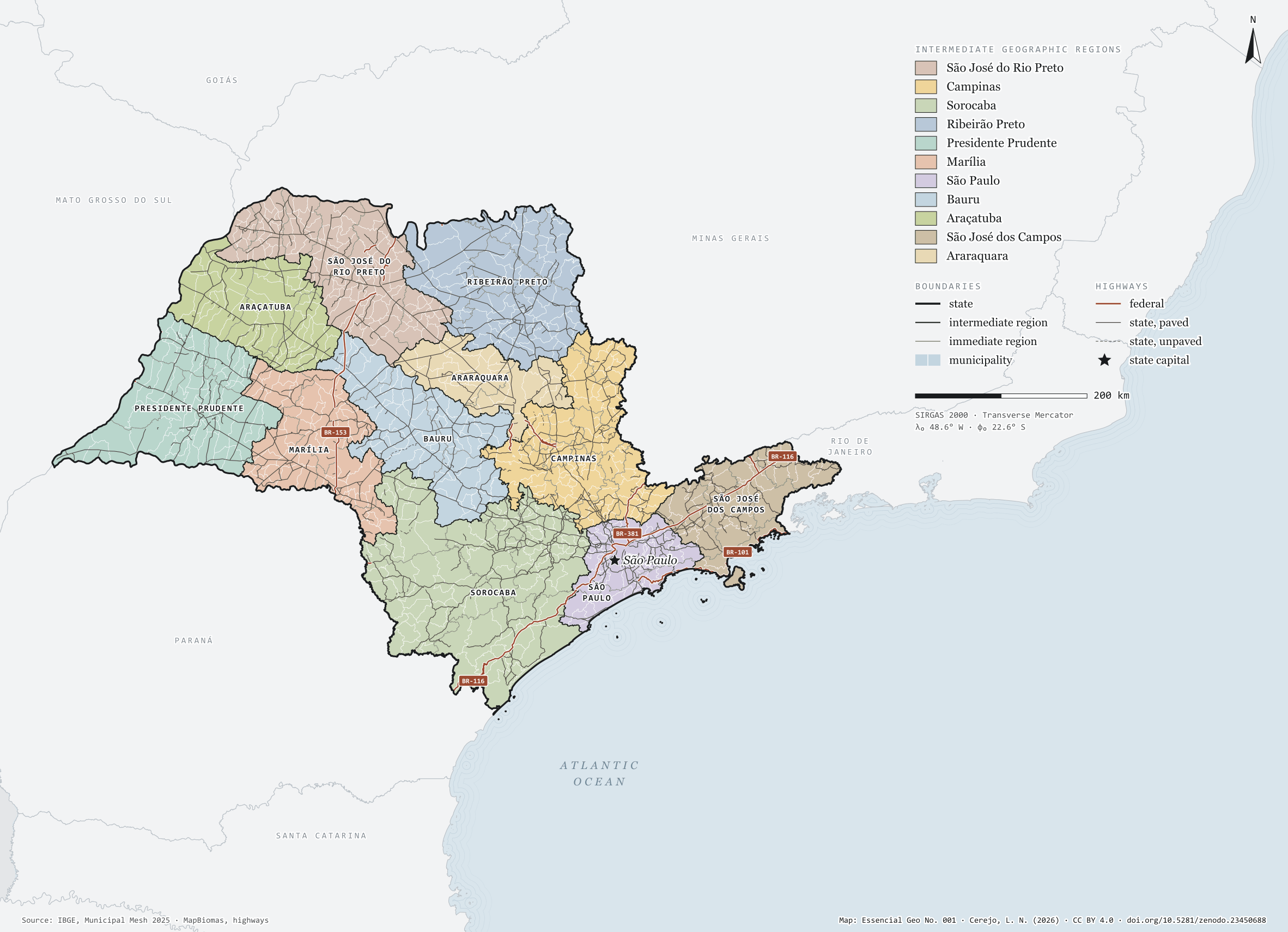
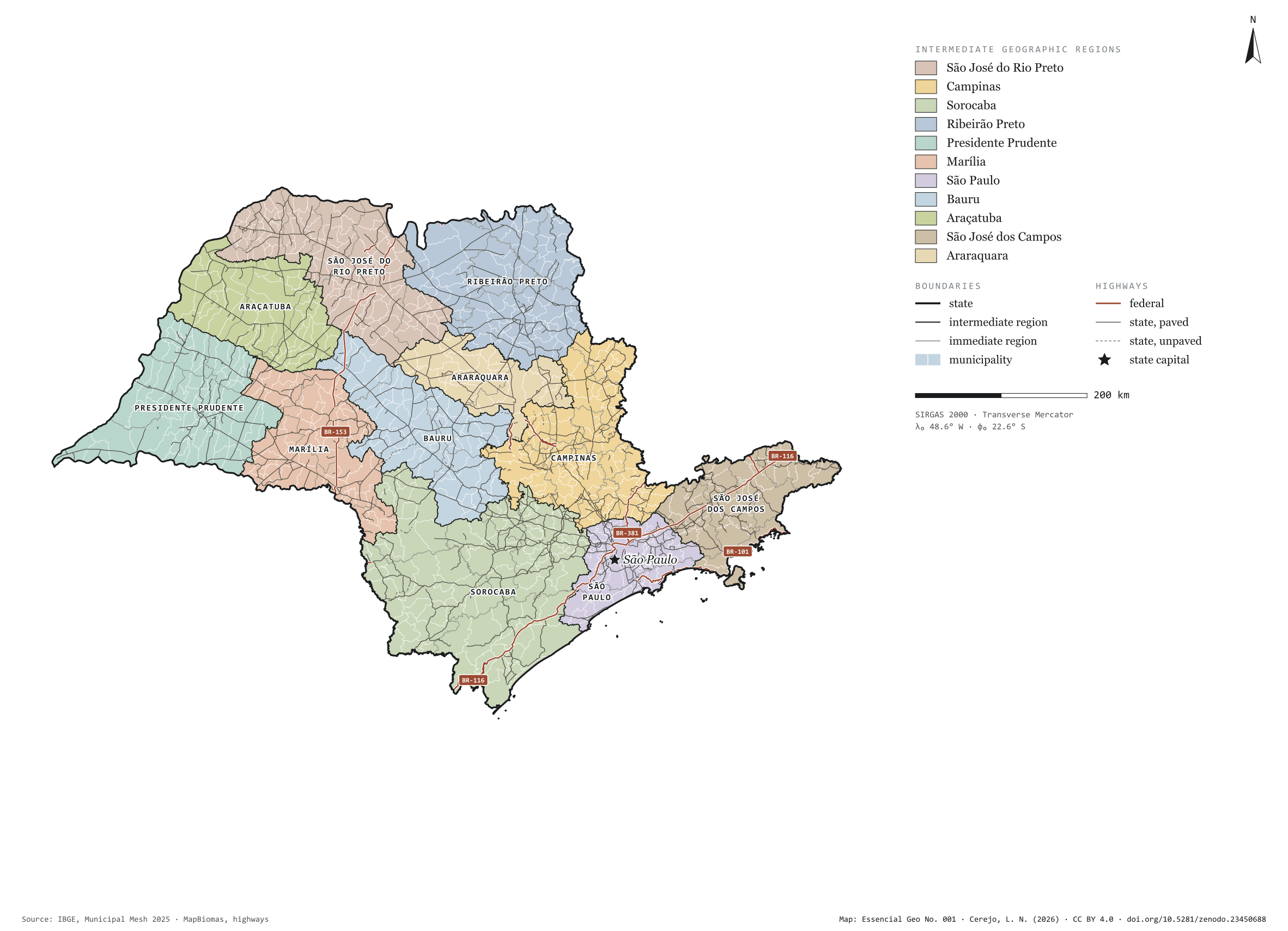
Fig. 001São Paulo state (SP)EPSG:4674Source: IBGE, MapBiomas, Natural Earth
São Paulo has 645 municipalities across 248,000 km², almost three per cent of Brazil. IBGE groups them into 53 immediate regions, drawn around the towns that supply jobs, trade and services to their surroundings, and into 11 intermediate regions that tie those networks together. São José do Rio Preto, in the north-west, gathers a hundred small municipalities; São Paulo, fifty, nearly all pressed against the capital. This plate opens the series “Brazil, state by state”: a clean base, with official boundaries and the paved road network, for anyone who needs to start a map of the state without losing the first afternoon gathering files.
Technical record · downloads · citation
At a glance
Municipalities per intermediate region (municipalities)
São José do Rio Preto100
Campinas87
Sorocaba78
Ribeirão Preto64
Presidente Prudente55
Marília54
São Paulo50
Bauru48
Araçatuba44
São José dos Campos39
Araraquara26
Area
248,220km²
Largest municipality: Iguape (1,978 km²); smallest: Águas de São Pedro (3.4 km²)
Paved highways
18,131km
1,402 km federal and 17,200 km state highways, paved or not
Layers
municipiospolygon645 municipalities, with IBGE code, regions, urban concentration and area (km²)
regioes_intermediariaspolygon11 intermediate geographic regions
regioes_imediataspolygon53 immediate geographic regions
limite_estadualpolygonBoundary of the federative unit
rodoviaslineFederal and state highways: route number, surface, physical status, carriageways
capitalpointIndicative point for the capital (not the exact seat)
The map without a frame, with legend, scale, reference system and credit written on it: ready for papers, lectures and slides. In two versions: with the basemap (neighbours and sea) or only the mapped area, on white.
CEREJO, Lucas Nakamura. São Paulo: divisão territorial e rodovias. Versão 1.0.0. [S. l.]: Zenodo, 2026. Conjunto de dados. DOI: 10.5281/zenodo.23450688. Disponível em: https://doi.org/10.5281/zenodo.23450688. Acesso em: 10 nov. 2026.
Cerejo, L. N. (2026). São Paulo: divisão territorial e rodovias [São Paulo: Territorial divisions and highways] (Version 1.0.0) [Data set]. Zenodo. https://doi.org/10.5281/zenodo.23450688
@dataset{cerejo2026_estado_sao_paulo,
  author    = {Cerejo, Lucas Nakamura},
  title     = {São Paulo: Divisão territorial e rodovias},
  year      = {2026},
  publisher = {Zenodo},
  version   = {1.0.0},
  doi       = {10.5281/zenodo.23450688},
  url       = {https://doi.org/10.5281/zenodo.23450688},
  language  = {portuguese},
  note      = {English title: São Paulo: Territorial divisions and highways. Licence CC BY 4.0}
}