Skip to content
Essencial

Collection · 3 plates

Water in São Paulo

River basins, the drainage network and protected areas: the path of water across the state.

3 of 3 published

In reading order, from the first to the latest. All collections

The route

Read in order: each plate adds a layer to the one before.

Start with the first plate
  1. Plate 1/3 · No. 036 River basins Twenty-two homes for the same rain
  2. Plate 2/3 · No. 037 Drainage network Rivers that turn their backs on the sea
  3. Plate 3/3 · No. 038 Protected areas Where the forest still keeps the spring
Every plate, in full

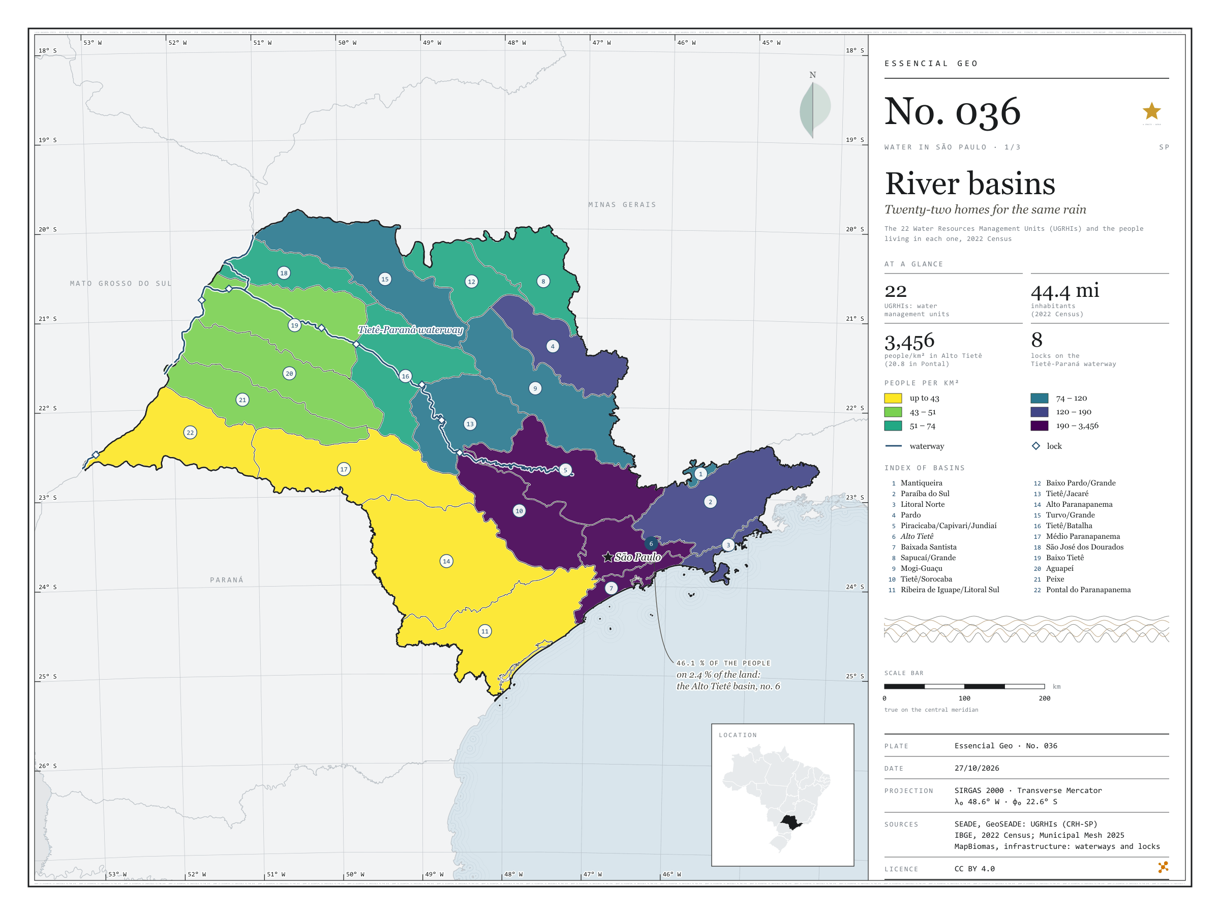
No. 036 Hydrography Water in São Paulo 1/3

River basins

Twenty-two homes for the same rain

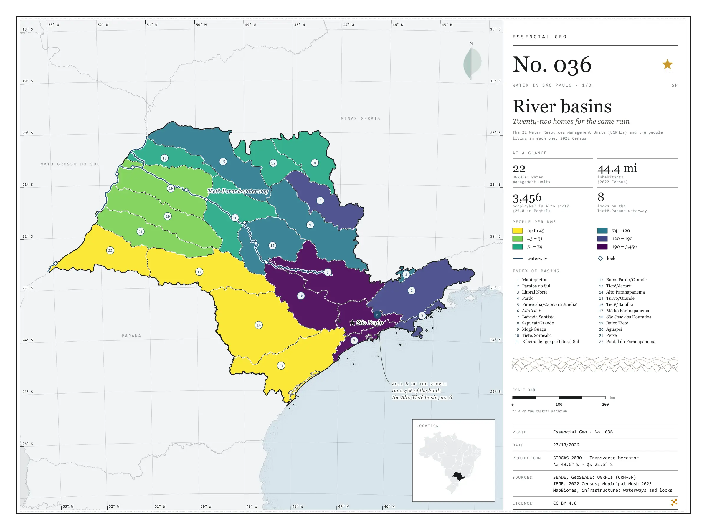
Fig. 036 São Paulo state (SP) EPSG:4674 Source: SEADE, IBGE, MapBiomas

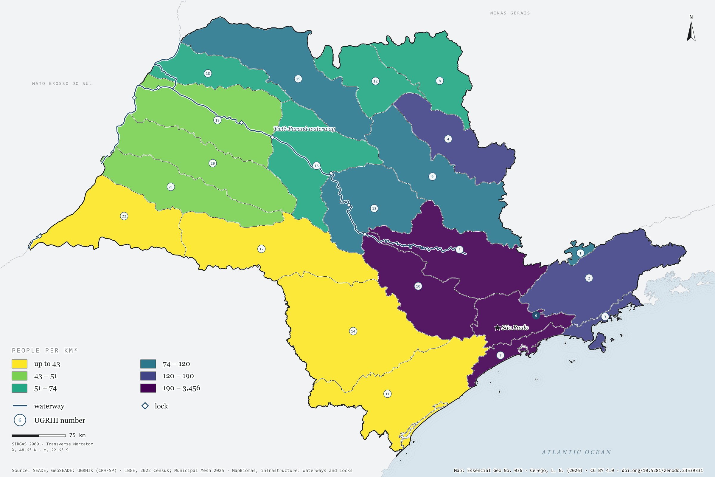
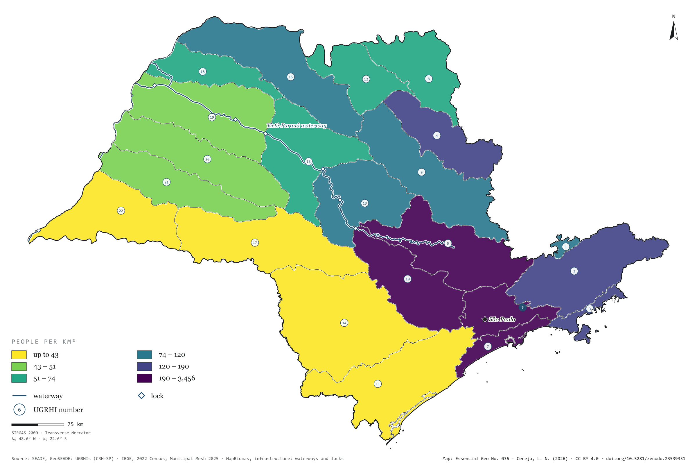
To look after its water, São Paulo does not use the map of municipalities but the map of basins: 22 Water Resources Management Units, the UGRHIs. Coloured by the 2022 Census population, they show a state that is unequal under the same rain. The municipalities of Alto Tietê, around the capital, hold 20.5 million people, 46.1% of the state’s population, on 2.4% of its land: 3,456 people per km². In Pontal do Paranapanema there are 20.8. Along the Tietê and the Paraná runs the waterway too, with its eight locks drawn on the map. First plate of the collection “Water in São Paulo”.

Technical record · downloads · citation

At a glance

Share of São Paulo’s population, by UGRHI (top five) (%)
  • 6 · Alto Tietê 46
  • 5 · Piracicaba/Capivari/Jundiaí 13
  • 10 · Tietê/Sorocaba 5.1
  • 2 · Paraíba do Sul 5.1
  • 7 · Baixada Santista 4.1
Density in Alto Tietê

3,456 people/km²

In Pontal do Paranapanema: 20.8 people/km²

Layers

  • ugrhi polygon 22 UGRHIs: area, municipalities, 2022 population and density
  • municipios polygon 645 municipalities, with the assigned UGRHI, the share of territory in it and the 2022 population
  • hidrovia line Tietê-Paraná waterway
  • eclusas point 8 locks on the waterway
  • limite_estadual polygon State boundary

Metadata

Extent
São Paulo state (SP)
CRS / Projection
SIRGAS 2000 (EPSG:4674)
EPSG:4674
Software
Python · GeoPandas · GDAL · QGIS · Node.js · d3-geo
Method
Each municipality assigned to the UGRHI covering most of its territory; 2022 Census population summed by UGRHI and divided by basin area, in six quantile classes.
Version
v1.0.0
Licence
CC BY 4.0

Downloads

Figure to reuse

The map without a frame, with legend, scale, reference system and credit written on it: ready for papers, lectures and slides. In two versions: with the basemap (neighbours and sea) or only the mapped area, on white.

Point a camera at it to open this page.

How to cite

Cerejo, L. N. (2026). Bacias hidrográficas: vinte e duas casas para a mesma chuva [River basins: Twenty-two homes for the same rain] (Version 1.0.0) [Data set]. Zenodo. https://doi.org/10.5281/zenodo.23539331

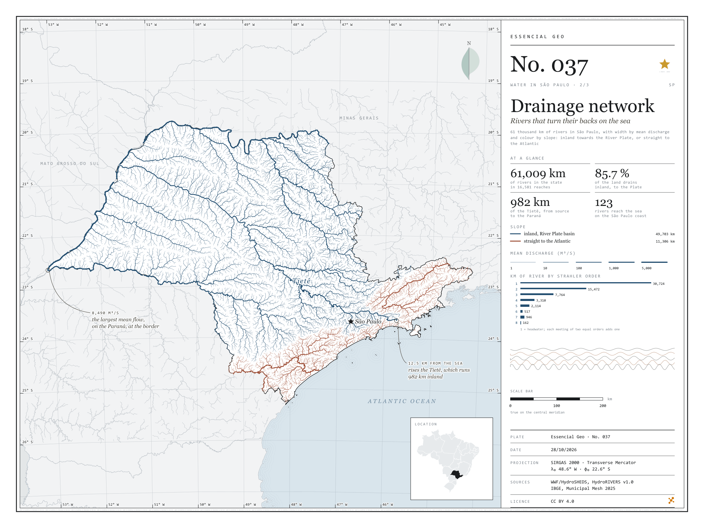
No. 037 Hydrography Water in São Paulo 2/3

Drainage network

Rivers that turn their backs on the sea

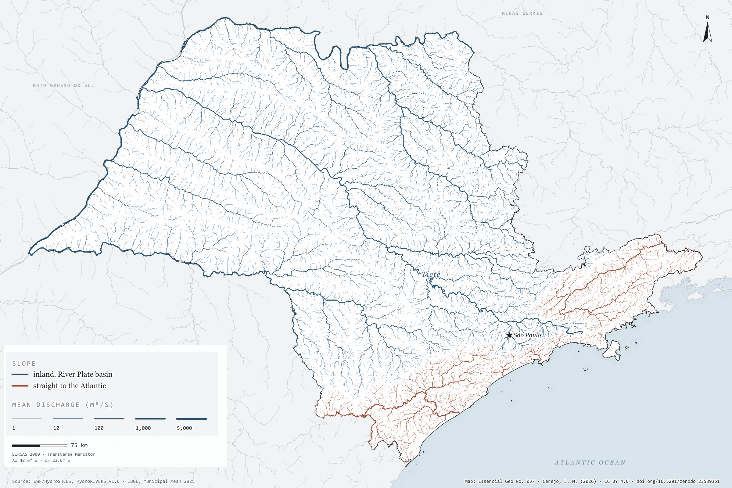
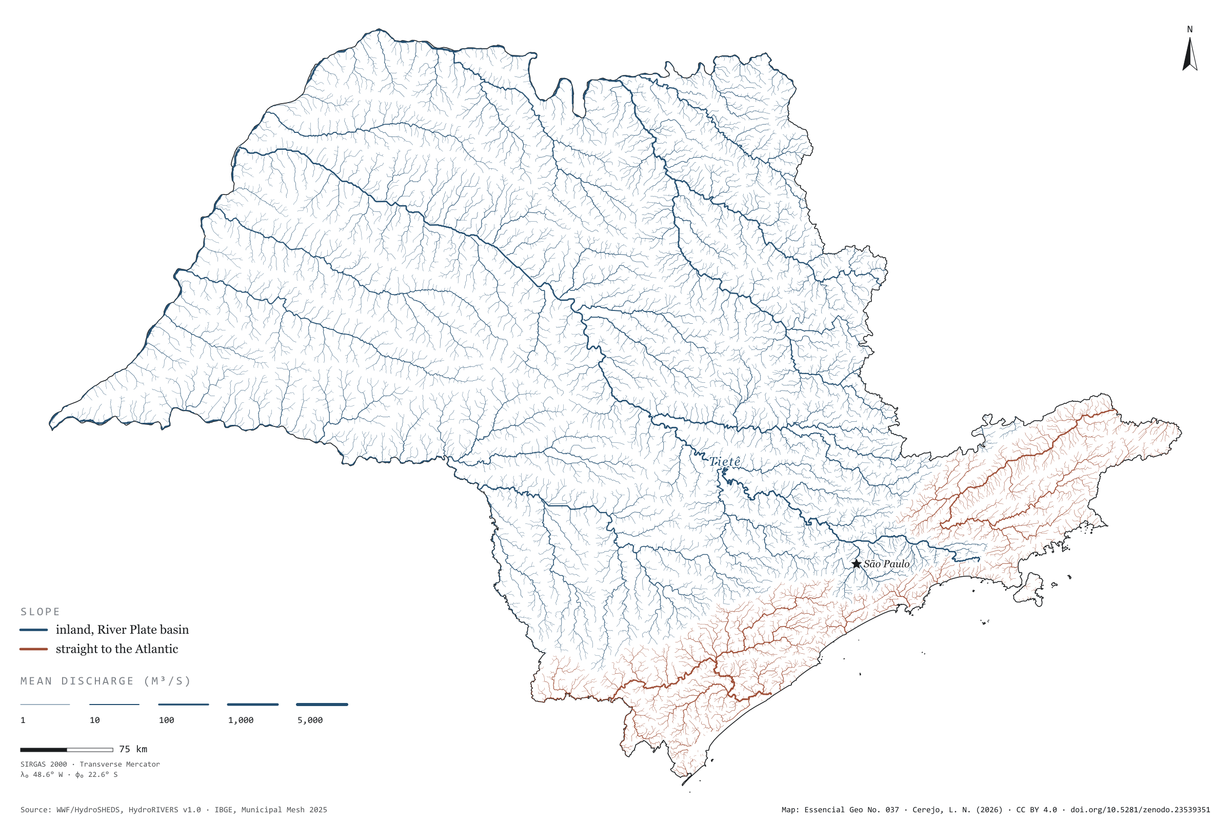
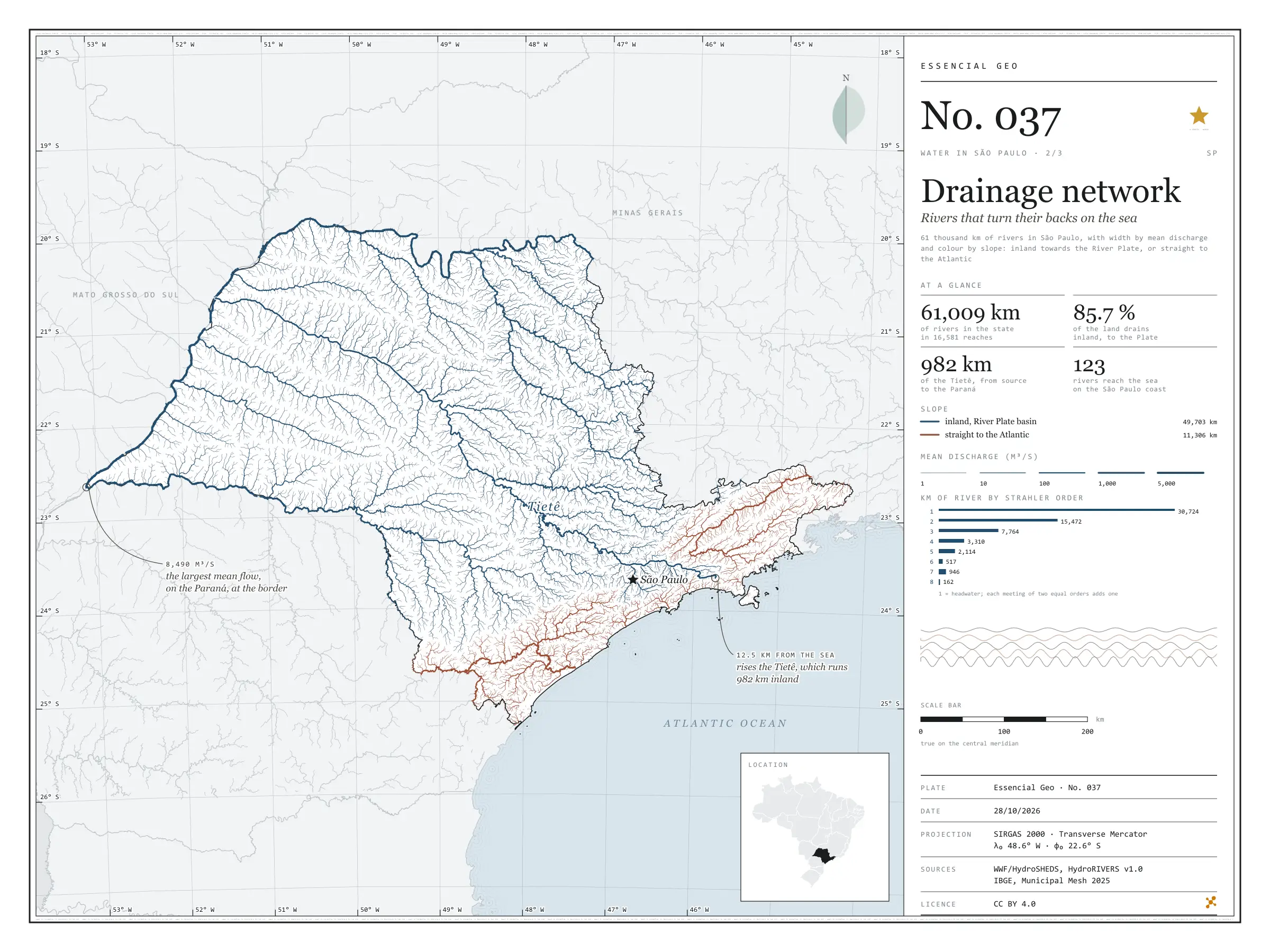
Fig. 037 State of São Paulo (SP) EPSG:4674 Source: WWF / HydroSHEDS, IBGE

The Tietê rises 12.5 km from the sea and runs 982 km the other way, inland, to the Paraná. It is not alone: 85.7% of the area drained by São Paulo’s rivers flows inland and on down the Paraná to the River Plate, between Argentina and Uruguay. The Serra do Mar and the Mantiqueira divide the waters. Only the coastal strip, the Ribeira de Iguape and the Paraíba do Sul valley send their rain straight to the Atlantic, through 123 river mouths on the São Paulo coast. The map draws 61,009 km of rivers, each reach as wide as its mean discharge: from headwater streams to the Paraná on the state border, with 8,490 m³/s. Second plate of the collection “Water in São Paulo”.

Technical record · downloads · citation

At a glance

Kilometres of river in São Paulo, by slope (km)
  • Para o interior, bacia do Prata 81.5%
  • Direto para o Atlântico 18.5%
Kilometres of river by Strahler order (km)
  • 1 30,724
  • 2 15,472
  • 3 7,764
  • 4 3,310
  • 5 2,114
  • 6 517
  • 7 946
  • 8 162
Drained area flowing inland

86 %

The rest flows straight to the Atlantic, through 123 mouths on the São Paulo coast

Layers

  • rios line 16,999 river reaches in the state and on its border: length, upstream area, mean discharge, Strahler order and slope
  • tiete line The Tietê from its source to the Paraná, 982 km
  • limite_estadual polygon State boundary

Metadata

Extent
State of São Paulo (SP)
CRS / Projection
SIRGAS 2000 (EPSG:4674)
EPSG:4674
Software
Python · GeoPandas · GDAL · QGIS · Node.js · d3-geo
Method
HydroRIVERS reaches clipped to São Paulo, with width by modelled mean discharge and slope by the outlet of the river system; the Tietê traced from mouth to source along the reach with the largest upstream area.
Version
v1.0.0
Licence
CC BY 4.0

Downloads

Figure to reuse

The map without a frame, with legend, scale, reference system and credit written on it: ready for papers, lectures and slides. In two versions: with the basemap (neighbours and sea) or only the mapped area, on white.

Point a camera at it to open this page.

How to cite

Cerejo, L. N. (2026). Rede de drenagem: os rios que dão as costas ao mar [Drainage network: Rivers that turn their backs on the sea] (Version 1.0.0) [Data set]. Zenodo. https://doi.org/10.5281/zenodo.23539351

No. 038 Biomes Water in São Paulo 3/3

Protected areas

Where the forest still keeps the spring

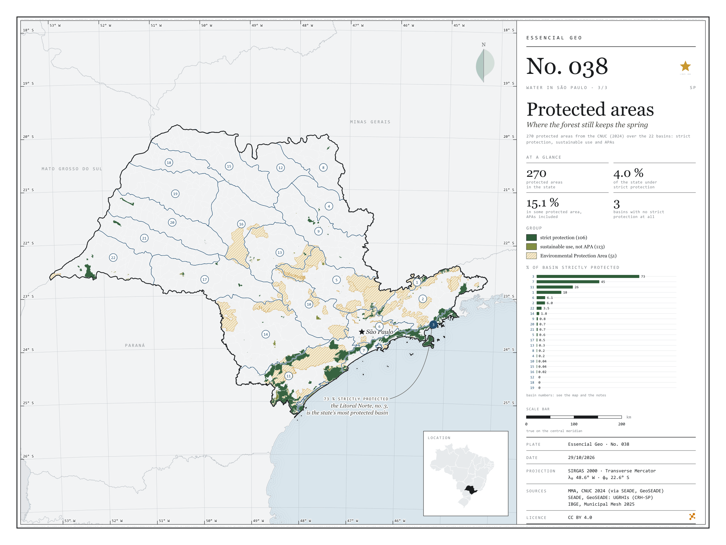
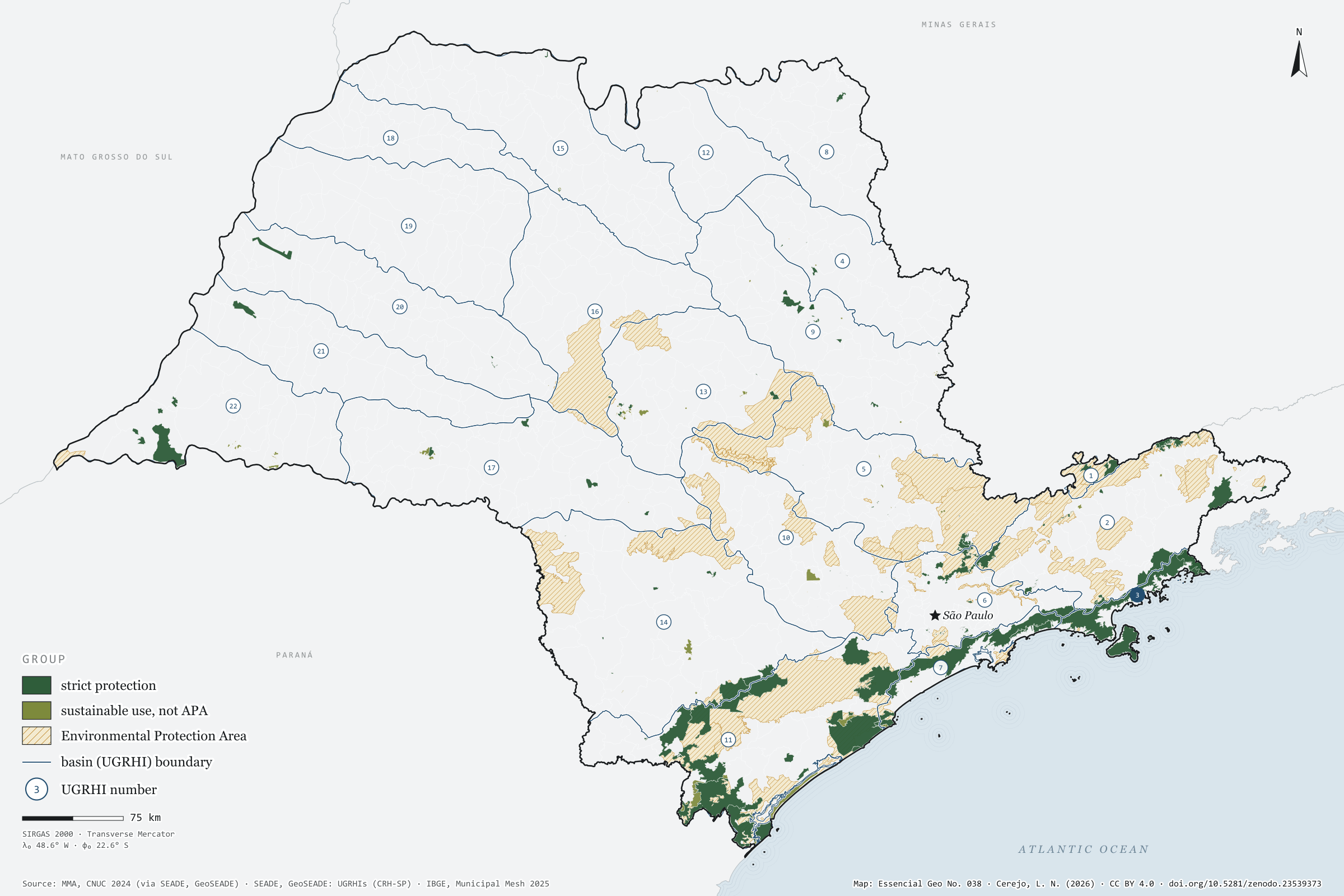
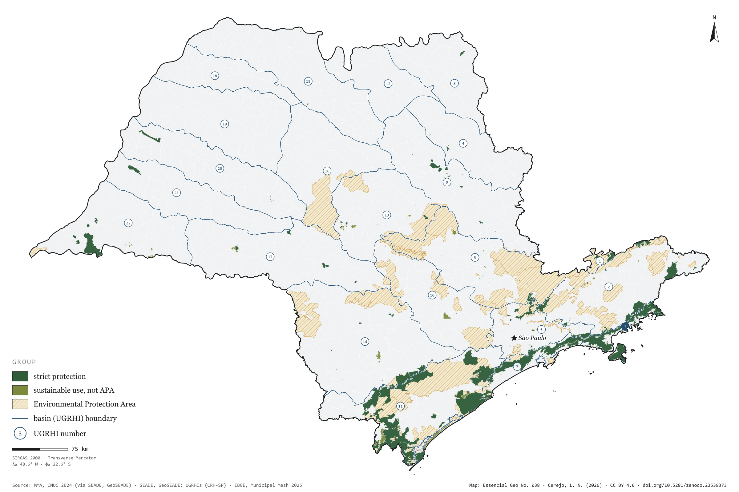
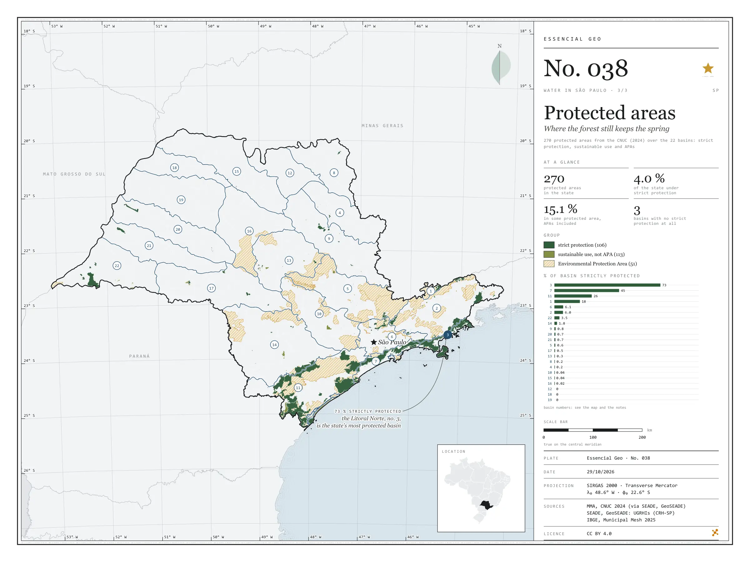
Fig. 038 São Paulo state (SP) EPSG:4674 Source: MMA, SEADE, IBGE

In the Litoral Norte, 73% of the basin lies in strictly protected areas, most of it in the Serra do Mar State Park. In the west of the state, three basins — Baixo Tietê, São José dos Dourados and Baixo Pardo/Grande — have none at all. Taken together, the 270 protected areas in the CNUC for São Paulo cover 15.1% of the territory, but only 4.0% under strict protection; nearly all the rest are Environmental Protection Areas, which allow settlement under rules. Over the 22 basins, the map shows where protected forest still keeps the springs: in the Serra do Mar and the Ribeira valley. Final plate of the collection “Water in São Paulo”.

Technical record · downloads · citation

At a glance

Share of basin under strict protection (top six) (%)
  • 3 · Litoral Norte 73
  • 7 · Baixada Santista 45
  • 11 · Ribeira de Iguape/Litoral Sul 26
  • 1 · Mantiqueira 18
  • 6 · Alto Tietê 6.1
  • 2 · Paraíba do Sul 6
São Paulo’s territory in protected areas

15 %

4.0% strictly protected; 51 APAs among the 270 units

Layers

  • unidades_conservacao polygon 270 protected areas: category, group, sphere, founding act and area in SP
  • ugrhi polygon 22 UGRHIs with the area and share under strict protection and in any protected area
  • limite_estadual polygon State boundary

Metadata

Extent
São Paulo state (SP)
CRS / Projection
SIRGAS 2000 (EPSG:4674)
EPSG:4674
Software
Python · GeoPandas · GDAL · QGIS · Node.js · d3-geo
Method
CNUC protected areas clipped to São Paulo’s territory; areas dissolved so overlaps are not counted twice, and crossed with the 22 UGRHIs.
Version
v1.0.0
Licence
CC BY 4.0

Downloads

Figure to reuse

The map without a frame, with legend, scale, reference system and credit written on it: ready for papers, lectures and slides. In two versions: with the basemap (neighbours and sea) or only the mapped area, on white.

Point a camera at it to open this page.

How to cite

Cerejo, L. N. (2026). Unidades de conservação: onde a floresta ainda guarda a nascente [Protected areas: Where the forest still keeps the spring] (Version 1.0.0) [Data set]. Zenodo. https://doi.org/10.5281/zenodo.23539373

Technical record

Technical record · No. 036

River basins

At a glance

Share of São Paulo’s population, by UGRHI (top five) (%)
  • 6 · Alto Tietê 46
  • 5 · Piracicaba/Capivari/Jundiaí 13
  • 10 · Tietê/Sorocaba 5.1
  • 2 · Paraíba do Sul 5.1
  • 7 · Baixada Santista 4.1
Density in Alto Tietê

3,456 people/km²

In Pontal do Paranapanema: 20.8 people/km²

Layers

  • ugrhi polygon 22 UGRHIs: area, municipalities, 2022 population and density
  • municipios polygon 645 municipalities, with the assigned UGRHI, the share of territory in it and the 2022 population
  • hidrovia line Tietê-Paraná waterway
  • eclusas point 8 locks on the waterway
  • limite_estadual polygon State boundary

Metadata

Extent
São Paulo state (SP)
CRS / Projection
SIRGAS 2000 (EPSG:4674)
EPSG:4674
Software
Python · GeoPandas · GDAL · QGIS · Node.js · d3-geo
Method
Each municipality assigned to the UGRHI covering most of its territory; 2022 Census population summed by UGRHI and divided by basin area, in six quantile classes.
Version
v1.0.0
Licence
CC BY 4.0

Downloads

Figure to reuse

The map without a frame, with legend, scale, reference system and credit written on it: ready for papers, lectures and slides. In two versions: with the basemap (neighbours and sea) or only the mapped area, on white.

Point a camera at it to open this page.

How to cite

Cerejo, L. N. (2026). Bacias hidrográficas: vinte e duas casas para a mesma chuva [River basins: Twenty-two homes for the same rain] (Version 1.0.0) [Data set]. Zenodo. https://doi.org/10.5281/zenodo.23539331

Data and plates under CC BY 4.0: use them in commercial drawings and papers, citing the source.

100%