Skip to content
Essencial

No. 038 Biomes Water in São Paulo 3/3

Protected areas

Where the forest still keeps the spring

Record, downloads and citation
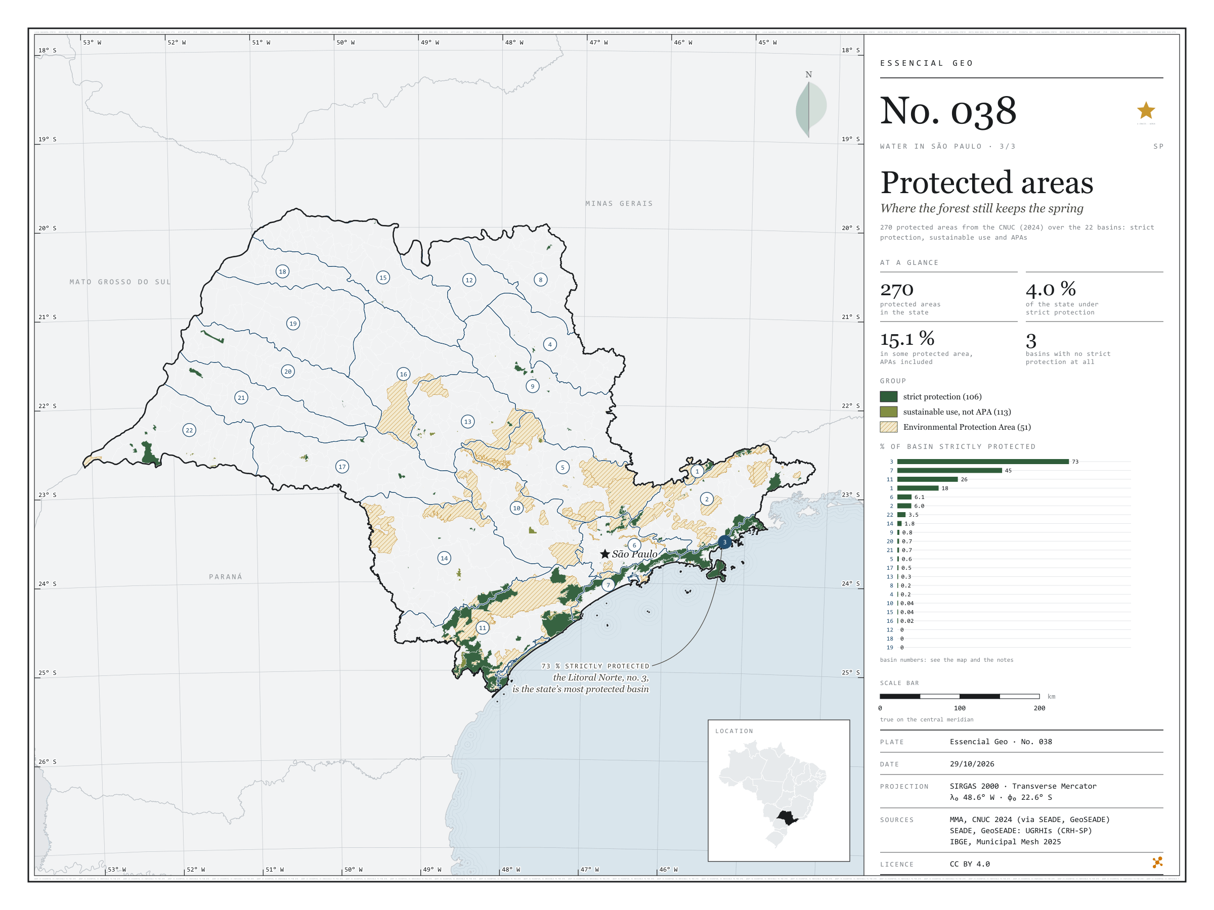
Fig. 038 São Paulo state (SP) EPSG:4674 Source: MMA, SEADE, IBGE

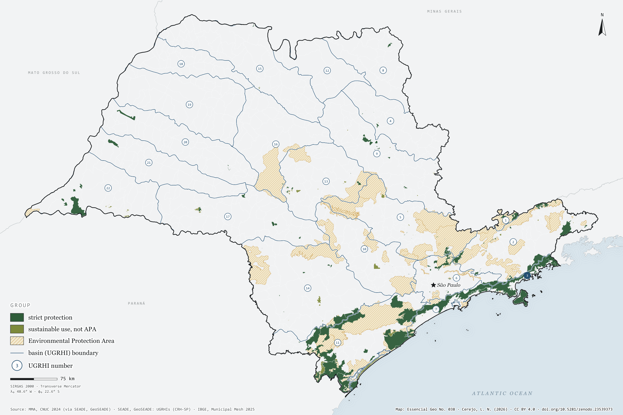
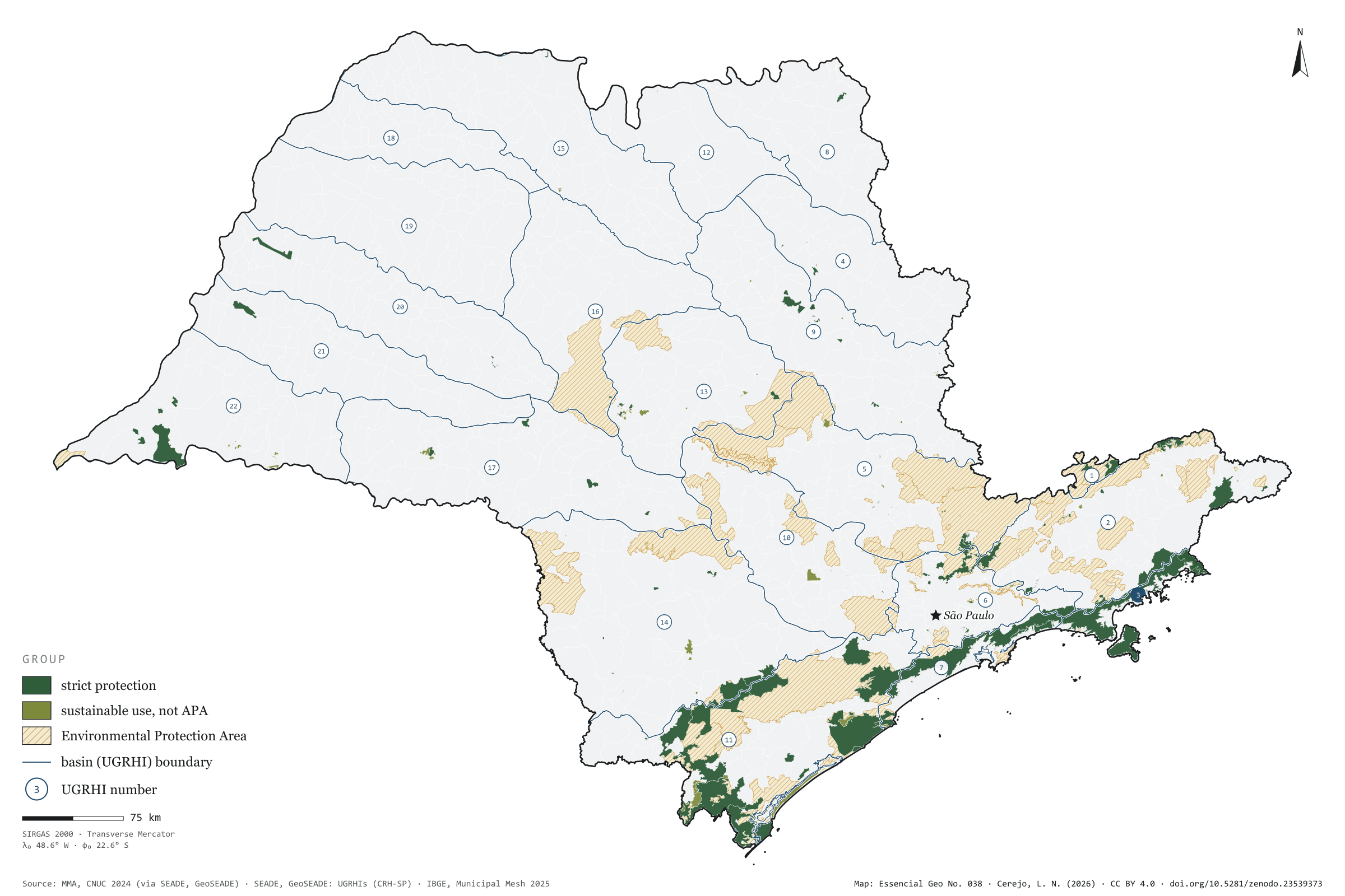
In the Litoral Norte, 73% of the basin lies in strictly protected areas, most of it in the Serra do Mar State Park. In the west of the state, three basins — Baixo Tietê, São José dos Dourados and Baixo Pardo/Grande — have none at all. Taken together, the 270 protected areas in the CNUC for São Paulo cover 15.1% of the territory, but only 4.0% under strict protection; nearly all the rest are Environmental Protection Areas, which allow settlement under rules. Over the 22 basins, the map shows where protected forest still keeps the springs: in the Serra do Mar and the Ribeira valley. Final plate of the collection “Water in São Paulo”.

Technical record · downloads · citation

At a glance

Share of basin under strict protection (top six) (%)
  • 3 · Litoral Norte 73
  • 7 · Baixada Santista 45
  • 11 · Ribeira de Iguape/Litoral Sul 26
  • 1 · Mantiqueira 18
  • 6 · Alto Tietê 6.1
  • 2 · Paraíba do Sul 6
São Paulo’s territory in protected areas

15 %

4.0% strictly protected; 51 APAs among the 270 units

Layers

  • unidades_conservacao polygon 270 protected areas: category, group, sphere, founding act and area in SP
  • ugrhi polygon 22 UGRHIs with the area and share under strict protection and in any protected area
  • limite_estadual polygon State boundary

Metadata

Extent
São Paulo state (SP)
CRS / Projection
SIRGAS 2000 (EPSG:4674)
EPSG:4674
Software
Python · GeoPandas · GDAL · QGIS · Node.js · d3-geo
Method
CNUC protected areas clipped to São Paulo’s territory; areas dissolved so overlaps are not counted twice, and crossed with the 22 UGRHIs.
Version
v1.0.0
Licence
CC BY 4.0

Downloads

Figure to reuse

The map without a frame, with legend, scale, reference system and credit written on it: ready for papers, lectures and slides. In two versions: with the basemap (neighbours and sea) or only the mapped area, on white.

Point a camera at it to open this page.

How to cite

Cerejo, L. N. (2026). Unidades de conservação: onde a floresta ainda guarda a nascente [Protected areas: Where the forest still keeps the spring] (Version 1.0.0) [Data set]. Zenodo. https://doi.org/10.5281/zenodo.23539373

How to read this plate area, projection, scale, legend and source
1 Area
São Paulo state (SP) The area the plate covers. Outside it, neighbours and sea are drawn in grey, just for orientation.
2 Coordinates and projection
SIRGAS 2000 (EPSG:4674) The layers are in SIRGAS 2000; the drawing’s projection is written in the colophon at the foot of the panel.
3 Scale
Graphic scale bar in the panel The scale bar is true on the central meridian; away from it, measured distances vary a little.
4 Legend and layers
3 layers in the GeoPackage · polygon Read the legend before the map: it tells you whether a colour is a rate or a class, and whether a circle is a total.
5 Sources
MMA (2024); SEADE; IBGE (2025) Every figure comes from a public source, with its year. The data sheet gives each one’s address.

Download

Layers, table and figures, under CC BY 4.0. Cite with the DOI.

Full record and citation

Method notes · No. 038

Protected areas over São Paulo’s river basins

Português · English

Plate No. 038, the last of three in the collection Water in São Paulo: after the basins and the drainage, how much of each basin is protected.

What the files contain

Layer (GPKG)GeometryContents
unidades_conservacaopolygon270 units: cd_cnuc, nome_uc, nome_abrev, categoria, grupo, esfera, cria_ano, cria_ato, org_gestor, area_cnuc_ha (area declared in the register, whole unit), area_sp_km2 (part in SP), apa, grupo_mapa
ugrhipolygon22 UGRHIs: km2_protecao_integral, km2_qualquer_uc, pct_protecao_integral, pct_qualquer_uc, ucs (units touching the basin)
limite_estadualpolygonoutline of the state

The GPKG is zipped and attached to the agua-sp-2026 release. Its QGIS styles match the plate: strict protection in forest green, sustainable use in olive and APAs in translucent straw, with the largest underneath. The ugrhi layer opens as an outline and has a second style, protecao_integral, which colours the basins by percentage.

The CSV holds the table of the 270 units, in UTF-8, without geometry.

Method

  1. Federal, state and municipal protected areas, strict-protection and sustainable-use, from the CNUC as published by GeoSEADE (2024 edition): 270 units, all active.
  2. Each polygon is repaired where invalid and clipped to São Paulo’s territory (the 2025 Municipal Mesh boundary). Units crossing the state line, such as the Serra da Mantiqueira APA, enter with their São Paulo part only.
  3. Areas are dissolved before measuring, so overlapping units (a park inside an APA, for instance) are not counted twice. Areas in km² in the Albers equal-area conic projection IBGE uses.
  4. Each UGRHI’s share under strict protection and in any protected area is the dissolved area inside the basin divided by the basin’s area within São Paulo.

Limitations

  • The marine part of the units is left out: the clip is the municipalities’ territory. The Marine APAs of the Litoral Norte, Centro and Sul appear only where they touch land.
  • area_cnuc_ha is the area declared in the register, for the whole unit; area_sp_km2 is measured here, in São Paulo only. The two may differ.
  • Private Natural Heritage Reserves (84) are small and barely show at the plate’s scale, but they are in the GPKG.
  • The CNUC depends on submissions from the managing bodies: recent municipal units may be missing.

View this map’s folder on GitHub

Technical record

Technical record · No. 038

Protected areas

At a glance

Share of basin under strict protection (top six) (%)
  • 3 · Litoral Norte 73
  • 7 · Baixada Santista 45
  • 11 · Ribeira de Iguape/Litoral Sul 26
  • 1 · Mantiqueira 18
  • 6 · Alto Tietê 6.1
  • 2 · Paraíba do Sul 6
São Paulo’s territory in protected areas

15 %

4.0% strictly protected; 51 APAs among the 270 units

Layers

  • unidades_conservacao polygon 270 protected areas: category, group, sphere, founding act and area in SP
  • ugrhi polygon 22 UGRHIs with the area and share under strict protection and in any protected area
  • limite_estadual polygon State boundary

Metadata

Extent
São Paulo state (SP)
CRS / Projection
SIRGAS 2000 (EPSG:4674)
EPSG:4674
Software
Python · GeoPandas · GDAL · QGIS · Node.js · d3-geo
Method
CNUC protected areas clipped to São Paulo’s territory; areas dissolved so overlaps are not counted twice, and crossed with the 22 UGRHIs.
Version
v1.0.0
Licence
CC BY 4.0

Downloads

Figure to reuse

The map without a frame, with legend, scale, reference system and credit written on it: ready for papers, lectures and slides. In two versions: with the basemap (neighbours and sea) or only the mapped area, on white.

Point a camera at it to open this page.

How to cite

Cerejo, L. N. (2026). Unidades de conservação: onde a floresta ainda guarda a nascente [Protected areas: Where the forest still keeps the spring] (Version 1.0.0) [Data set]. Zenodo. https://doi.org/10.5281/zenodo.23539373

100%