Skip to content
Essencial

Atlas · category · 003 maps

Hydrography / Basins

No. 037 Hydrography Water in São Paulo 2/3

Drainage network

Rivers that turn their backs on the sea

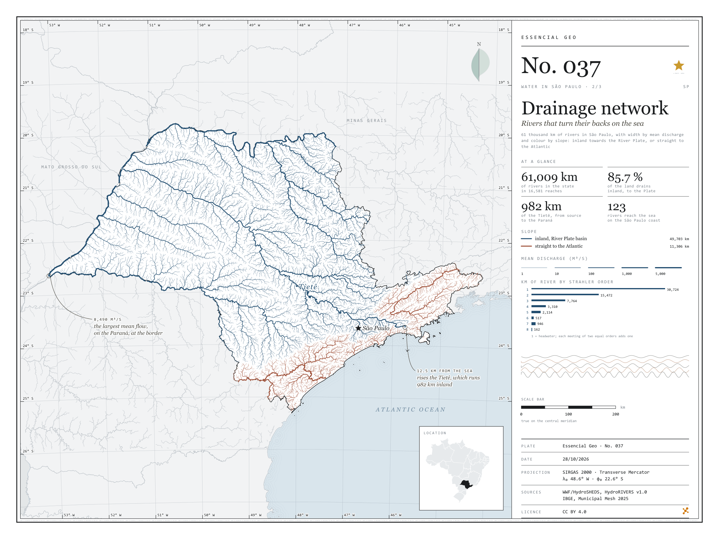
Fig. 037 State of São Paulo (SP) EPSG:4674 Source: WWF / HydroSHEDS, IBGE

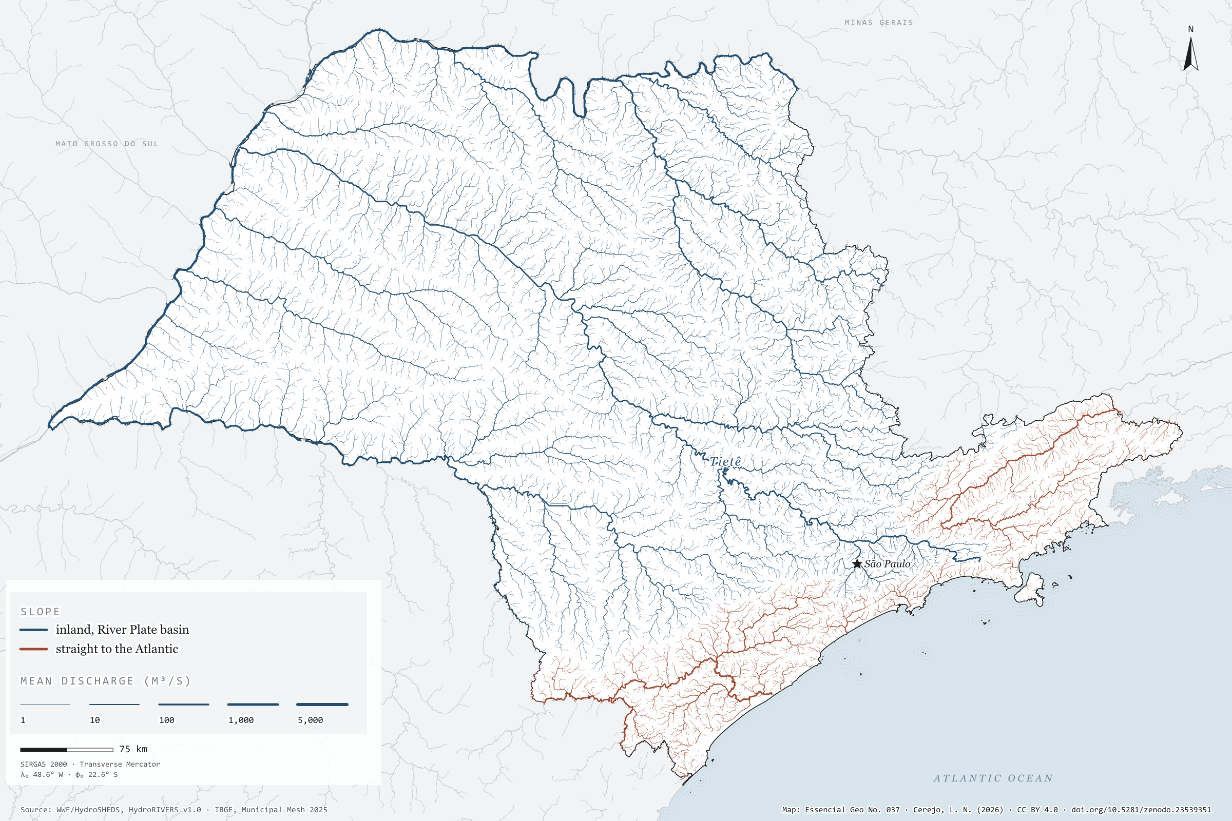
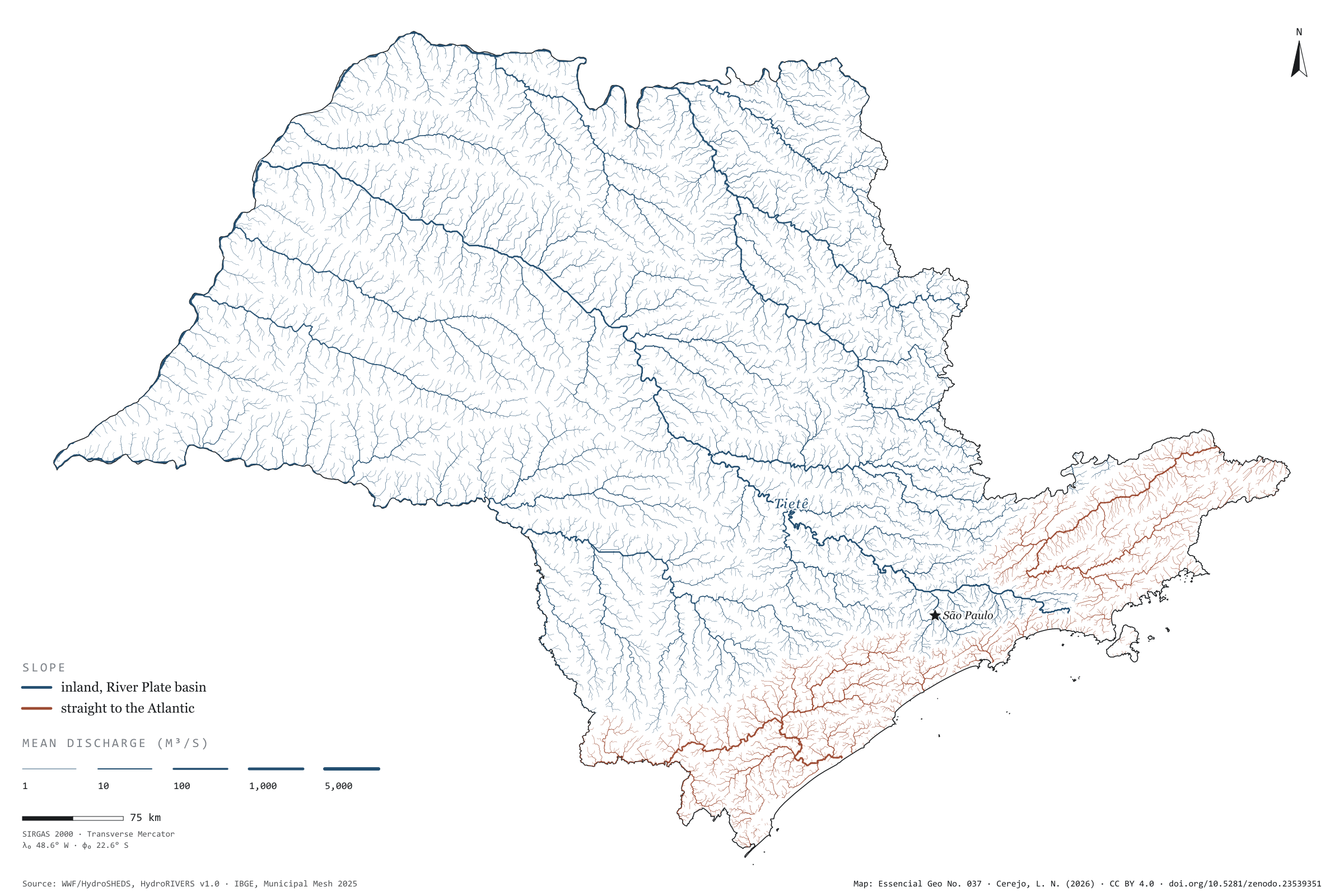
The Tietê rises 12.5 km from the sea and runs 982 km the other way, inland, to the Paraná. It is not alone: 85.7% of the area drained by São Paulo’s rivers flows inland and on down the Paraná to the River Plate, between Argentina and Uruguay. The Serra do Mar and the Mantiqueira divide the waters. Only the coastal strip, the Ribeira de Iguape and the Paraíba do Sul valley send their rain straight to the Atlantic, through 123 river mouths on the São Paulo coast. The map draws 61,009 km of rivers, each reach as wide as its mean discharge: from headwater streams to the Paraná on the state border, with 8,490 m³/s. Second plate of the collection “Water in São Paulo”.

Technical record · downloads · citation

At a glance

Kilometres of river in São Paulo, by slope (km)
  • Para o interior, bacia do Prata 81.5%
  • Direto para o Atlântico 18.5%
Kilometres of river by Strahler order (km)
  • 1 30,724
  • 2 15,472
  • 3 7,764
  • 4 3,310
  • 5 2,114
  • 6 517
  • 7 946
  • 8 162
Drained area flowing inland

86 %

The rest flows straight to the Atlantic, through 123 mouths on the São Paulo coast

Layers

  • rios line 16,999 river reaches in the state and on its border: length, upstream area, mean discharge, Strahler order and slope
  • tiete line The Tietê from its source to the Paraná, 982 km
  • limite_estadual polygon State boundary

Metadata

Extent
State of São Paulo (SP)
CRS / Projection
SIRGAS 2000 (EPSG:4674)
EPSG:4674
Software
Python · GeoPandas · GDAL · QGIS · Node.js · d3-geo
Method
HydroRIVERS reaches clipped to São Paulo, with width by modelled mean discharge and slope by the outlet of the river system; the Tietê traced from mouth to source along the reach with the largest upstream area.
Version
v1.0.0
Licence
CC BY 4.0

Downloads

Figure to reuse

The map without a frame, with legend, scale, reference system and credit written on it: ready for papers, lectures and slides. In two versions: with the basemap (neighbours and sea) or only the mapped area, on white.

Point a camera at it to open this page.

How to cite

Cerejo, L. N. (2026). Rede de drenagem: os rios que dão as costas ao mar [Drainage network: Rivers that turn their backs on the sea] (Version 1.0.0) [Data set]. Zenodo. https://doi.org/10.5281/zenodo.23539351

No. 036 Hydrography Water in São Paulo 1/3

River basins

Twenty-two homes for the same rain

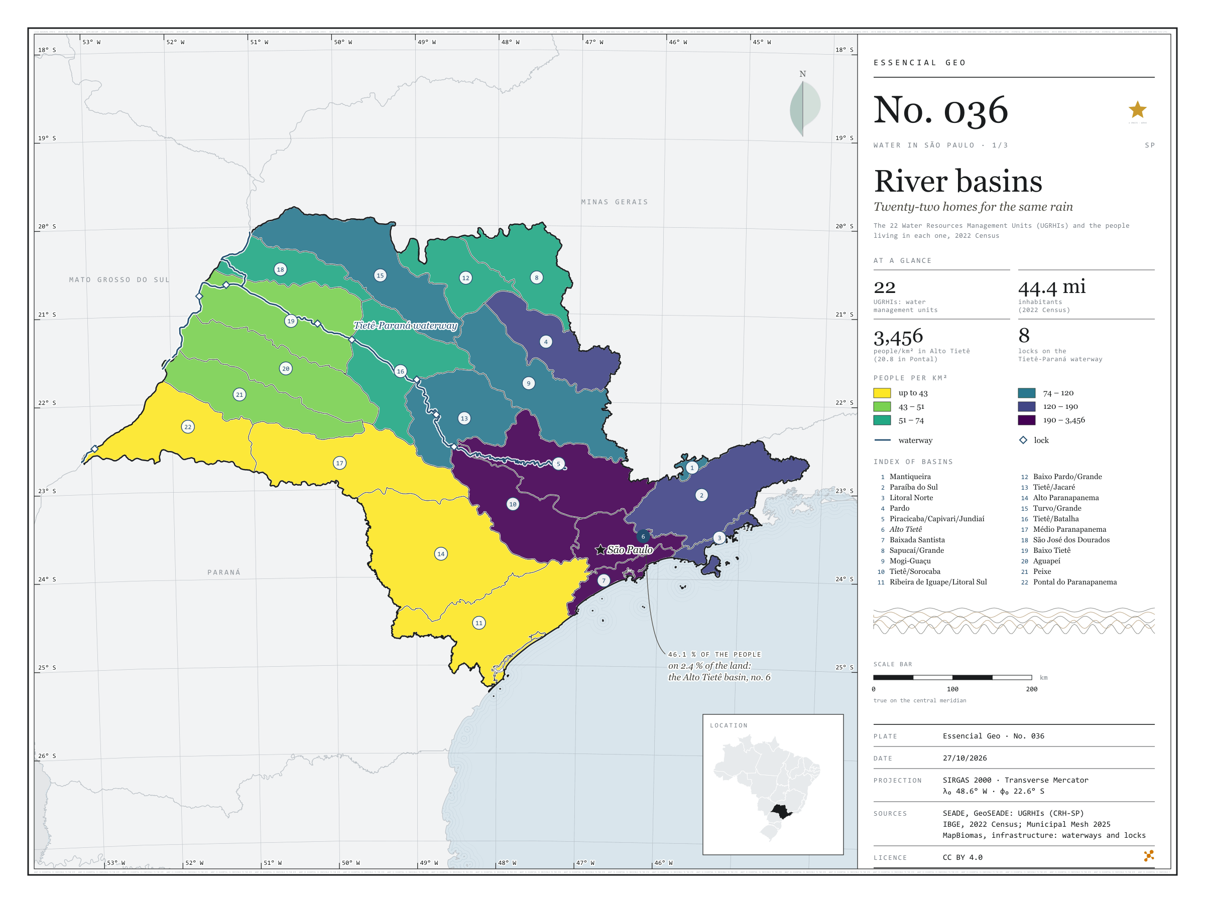
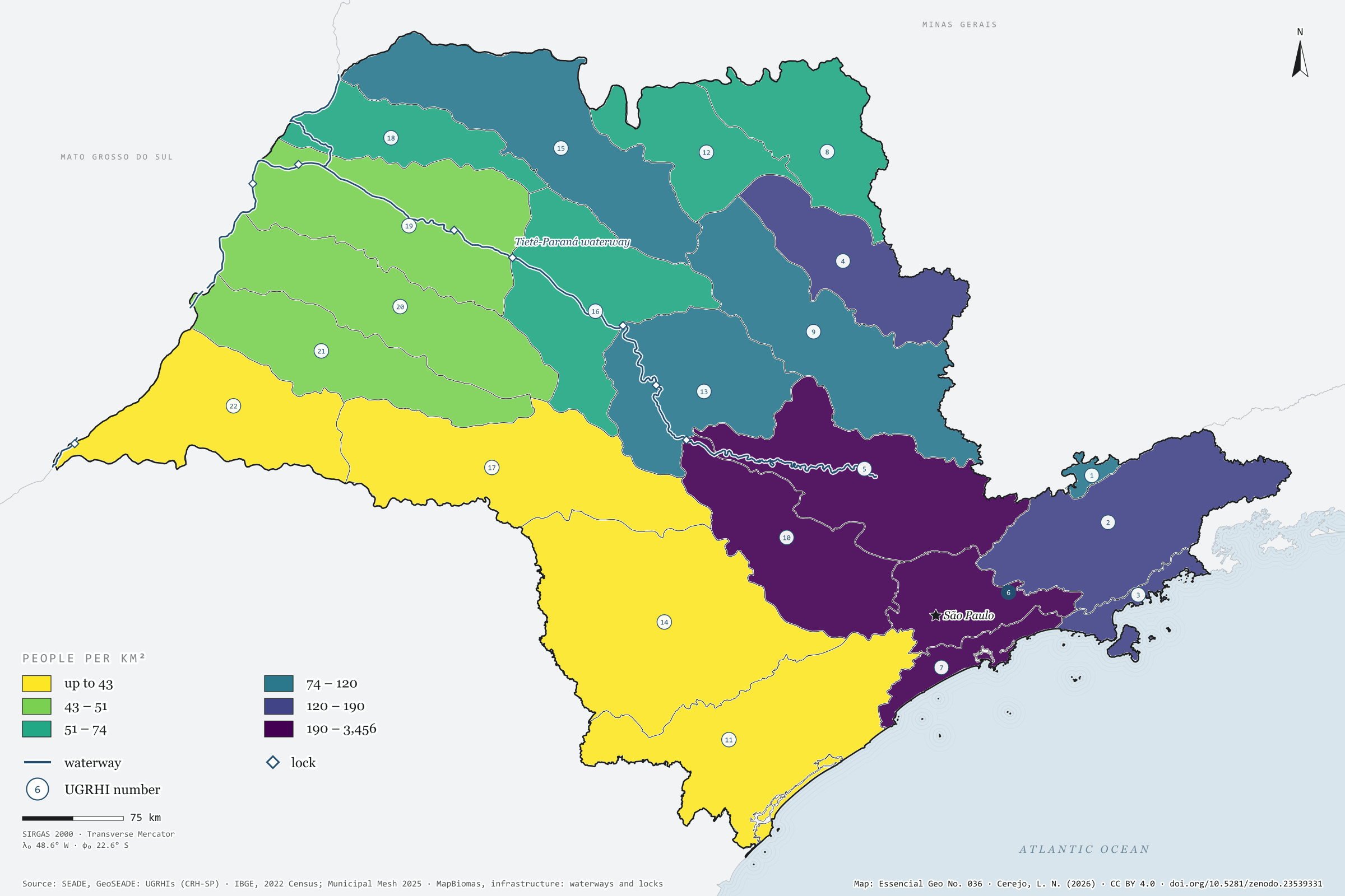
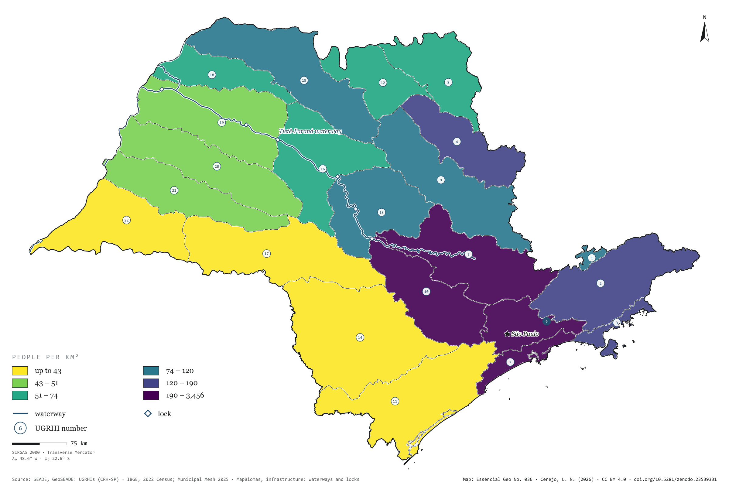
Fig. 036 São Paulo state (SP) EPSG:4674 Source: SEADE, IBGE, MapBiomas

To look after its water, São Paulo does not use the map of municipalities but the map of basins: 22 Water Resources Management Units, the UGRHIs. Coloured by the 2022 Census population, they show a state that is unequal under the same rain. The municipalities of Alto Tietê, around the capital, hold 20.5 million people, 46.1% of the state’s population, on 2.4% of its land: 3,456 people per km². In Pontal do Paranapanema there are 20.8. Along the Tietê and the Paraná runs the waterway too, with its eight locks drawn on the map. First plate of the collection “Water in São Paulo”.

Technical record · downloads · citation

At a glance

Share of São Paulo’s population, by UGRHI (top five) (%)
  • 6 · Alto Tietê 46
  • 5 · Piracicaba/Capivari/Jundiaí 13
  • 10 · Tietê/Sorocaba 5.1
  • 2 · Paraíba do Sul 5.1
  • 7 · Baixada Santista 4.1
Density in Alto Tietê

3,456 people/km²

In Pontal do Paranapanema: 20.8 people/km²

Layers

  • ugrhi polygon 22 UGRHIs: area, municipalities, 2022 population and density
  • municipios polygon 645 municipalities, with the assigned UGRHI, the share of territory in it and the 2022 population
  • hidrovia line Tietê-Paraná waterway
  • eclusas point 8 locks on the waterway
  • limite_estadual polygon State boundary

Metadata

Extent
São Paulo state (SP)
CRS / Projection
SIRGAS 2000 (EPSG:4674)
EPSG:4674
Software
Python · GeoPandas · GDAL · QGIS · Node.js · d3-geo
Method
Each municipality assigned to the UGRHI covering most of its territory; 2022 Census population summed by UGRHI and divided by basin area, in six quantile classes.
Version
v1.0.0
Licence
CC BY 4.0

Downloads

Figure to reuse

The map without a frame, with legend, scale, reference system and credit written on it: ready for papers, lectures and slides. In two versions: with the basemap (neighbours and sea) or only the mapped area, on white.

Point a camera at it to open this page.

How to cite

Cerejo, L. N. (2026). Bacias hidrográficas: vinte e duas casas para a mesma chuva [River basins: Twenty-two homes for the same rain] (Version 1.0.0) [Data set]. Zenodo. https://doi.org/10.5281/zenodo.23539331

No. 035 Hydrography Campinas Metropolitan Region 4/4

Riparian reserves of Campinas

Where water rises, the forest is missing

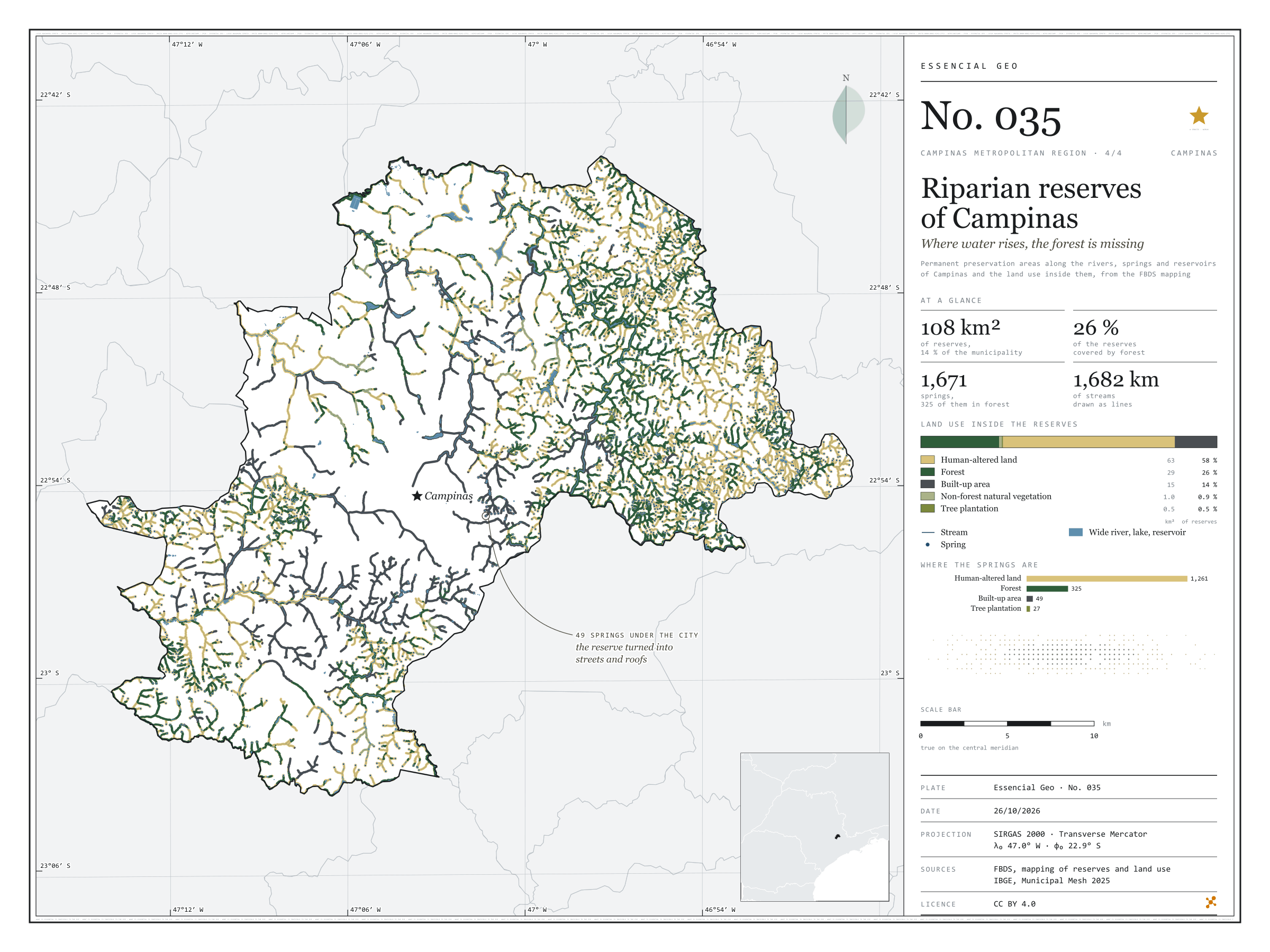
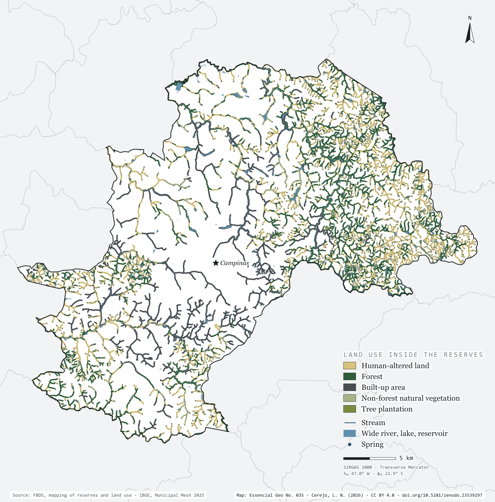
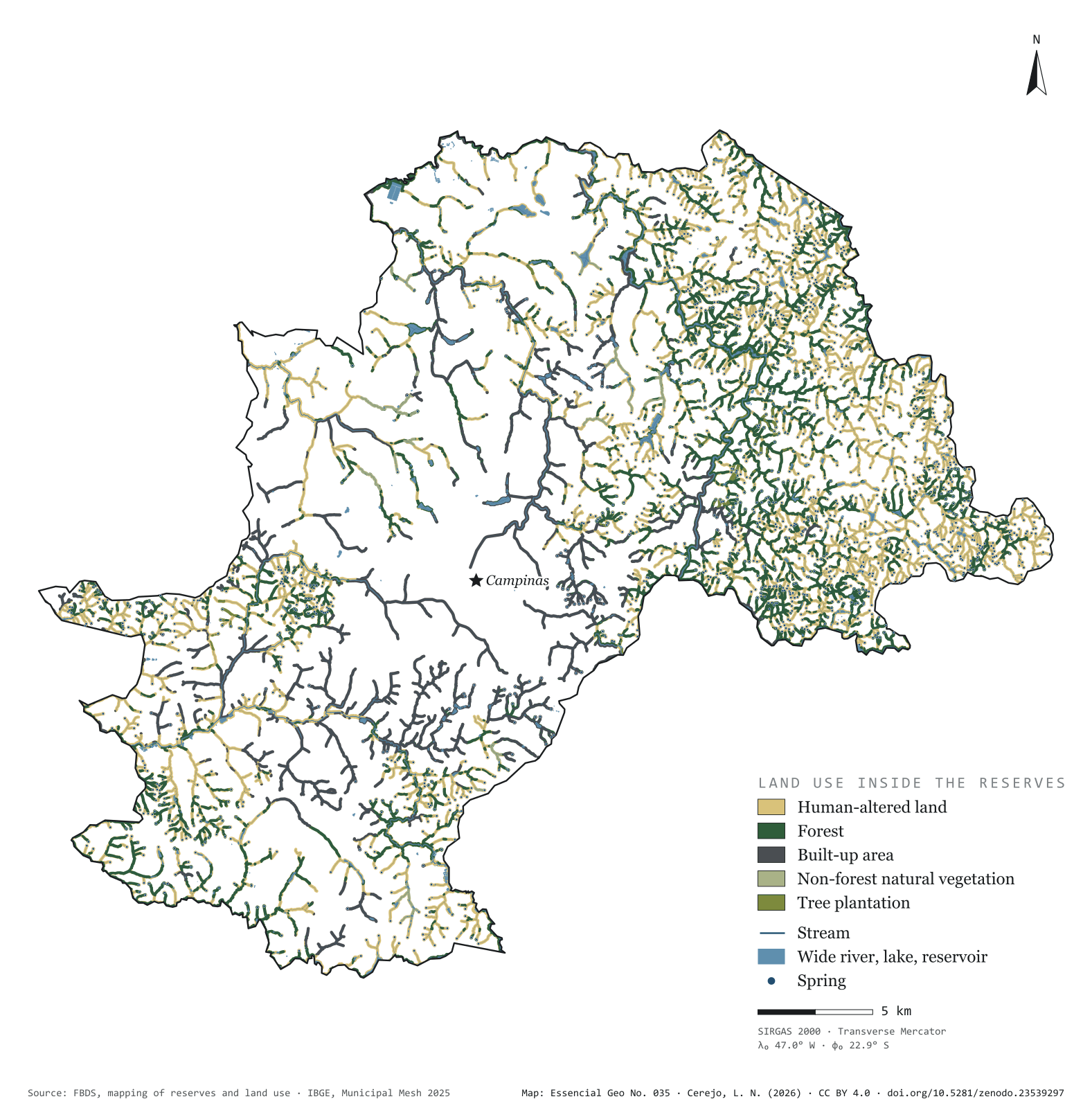
Fig. 035 Municipality of Campinas (SP) EPSG:4674 Source: FBDS, IBGE

Brazil’s Forest Code requires a strip of protected vegetation along every river, around every spring and on the shores of reservoirs: the permanent preservation areas, or APPs. In Campinas they add up to 108 km², 13.6% of the municipality, drawn over 1,682 km of streams and 1,671 springs. Only 26.4% of that strip is forest. The rest is pasture, cropland and bare soil (57.9%) or city (14.3%). Of the springs, 325 lie in forest and 1,261 in human-altered land; 49 have ended up under the streets and roofs of the urban area. On the map, green thickens in the east, in the hills of Sousas and Joaquim Egídio, and vanishes in the centre, where the streams run between houses. Fourth plate of the collection “Campinas Metropolitan Region”.

Technical record · downloads · citation

At a glance

Land use inside the reserves (km²) (km²)
  • Área antropizada 57.9%
  • Formação florestal 26.4%
  • Área edificada 14.3%
  • Formação não florestal 0.9%
  • Silvicultura 0.5%
Springs, by the land use class they fall in (springs)
  • Área antropizada 1,261
  • Formação florestal 325
  • Área edificada 49
  • Silvicultura 27
Reserve area covered by forest

26 %

28.6 of the municipality’s 108.1 km² of reserves

Layers

  • app_uso polygon Land use inside the reserves, in five classes, with area in hectares
  • app polygon 2,657 reserve strips, with their origin (stream, water body, spring) and width in metres
  • rios line 5,351 single-line stream segments, with width class and length
  • rios_duplos polygon 114 double-bank river reaches
  • massas_dagua polygon 967 lakes and reservoirs, 956 of them artificial
  • nascentes point 1,671 springs
  • limite_municipal polygon Boundary of Campinas

Metadata

Extent
Municipality of Campinas (SP)
CRS / Projection
SIRGAS 2000 (EPSG:4674)
EPSG:4674
Software
Python · GeoPandas · GDAL · QGIS · Node.js · d3-geo
Method
Reserves, stream network, springs and land use inside the reserves from the FBDS mapping of Campinas; area of each land use class summed and springs assigned to the class they fall in.
Version
v1.0.0
Licence
CC BY 4.0

Downloads

Figure to reuse

The map without a frame, with legend, scale, reference system and credit written on it: ready for papers, lectures and slides. In two versions: with the basemap (neighbours and sea) or only the mapped area, on white.

Point a camera at it to open this page.

How to cite

Cerejo, L. N. (2026). APPs de Campinas: onde a água nasce, a mata falta [Riparian reserves of Campinas: Where water rises, the forest is missing] (Version 1.0.0) [Data set]. Zenodo. https://doi.org/10.5281/zenodo.23539297

Technical record

Technical record · No. 037

Drainage network

At a glance

Kilometres of river in São Paulo, by slope (km)
  • Para o interior, bacia do Prata 81.5%
  • Direto para o Atlântico 18.5%
Kilometres of river by Strahler order (km)
  • 1 30,724
  • 2 15,472
  • 3 7,764
  • 4 3,310
  • 5 2,114
  • 6 517
  • 7 946
  • 8 162
Drained area flowing inland

86 %

The rest flows straight to the Atlantic, through 123 mouths on the São Paulo coast

Layers

  • rios line 16,999 river reaches in the state and on its border: length, upstream area, mean discharge, Strahler order and slope
  • tiete line The Tietê from its source to the Paraná, 982 km
  • limite_estadual polygon State boundary

Metadata

Extent
State of São Paulo (SP)
CRS / Projection
SIRGAS 2000 (EPSG:4674)
EPSG:4674
Software
Python · GeoPandas · GDAL · QGIS · Node.js · d3-geo
Method
HydroRIVERS reaches clipped to São Paulo, with width by modelled mean discharge and slope by the outlet of the river system; the Tietê traced from mouth to source along the reach with the largest upstream area.
Version
v1.0.0
Licence
CC BY 4.0

Downloads

Figure to reuse

The map without a frame, with legend, scale, reference system and credit written on it: ready for papers, lectures and slides. In two versions: with the basemap (neighbours and sea) or only the mapped area, on white.

Point a camera at it to open this page.

How to cite

Cerejo, L. N. (2026). Rede de drenagem: os rios que dão as costas ao mar [Drainage network: Rivers that turn their backs on the sea] (Version 1.0.0) [Data set]. Zenodo. https://doi.org/10.5281/zenodo.23539351

Data and plates under CC BY 4.0: use them in commercial drawings and papers, citing the source.

100%