Riparian reserves of Campinas
Where water rises, the forest is missing
Record, downloads and citationBrazil’s Forest Code requires a strip of protected vegetation along every river, around every spring and on the shores of reservoirs: the permanent preservation areas, or APPs. In Campinas they add up to 108 km², 13.6% of the municipality, drawn over 1,682 km of streams and 1,671 springs. Only 26.4% of that strip is forest. The rest is pasture, cropland and bare soil (57.9%) or city (14.3%). Of the springs, 325 lie in forest and 1,261 in human-altered land; 49 have ended up under the streets and roofs of the urban area. On the map, green thickens in the east, in the hills of Sousas and Joaquim Egídio, and vanishes in the centre, where the streams run between houses. Fourth plate of the collection “Campinas Metropolitan Region”.
Technical record · downloads · citation
At a glance
- Área antropizada 57.9%
- Formação florestal 26.4%
- Área edificada 14.3%
- Formação não florestal 0.9%
- Silvicultura 0.5%
26 %
Layers
- app_uso polygon Land use inside the reserves, in five classes, with area in hectares
- app polygon 2,657 reserve strips, with their origin (stream, water body, spring) and width in metres
- rios line 5,351 single-line stream segments, with width class and length
- rios_duplos polygon 114 double-bank river reaches
- massas_dagua polygon 967 lakes and reservoirs, 956 of them artificial
- nascentes point 1,671 springs
- limite_municipal polygon Boundary of Campinas
Metadata
- Sources
- FBDS — Brazilian Foundation for Sustainable Development: high-resolution mapping of land use, hydrography and riparian reserves
IBGE — Municipal Mesh 2025 (2025) - Extent
- Municipality of Campinas (SP)
- CRS / Projection
- SIRGAS 2000 (EPSG:4674)
EPSG:4674 - Software
- Python · GeoPandas · GDAL · QGIS · Node.js · d3-geo
- Method
- Reserves, stream network, springs and land use inside the reserves from the FBDS mapping of Campinas; area of each land use class summed and springs assigned to the class they fall in.
- Version
- v1.0.0
- Licence
- CC BY 4.0
Downloads
- GPKG Seven layers, SIRGAS 2000, with QGIS styles (.gpkg) 16.5 MB
- CSV Area of each land use class inside the reserves (.csv) 0.2 kB
- SVG Vector plate, for printing (.svg) 4.7 MB
- PNG Plate (PNG, 2400 px) (.png) 0.5 MB

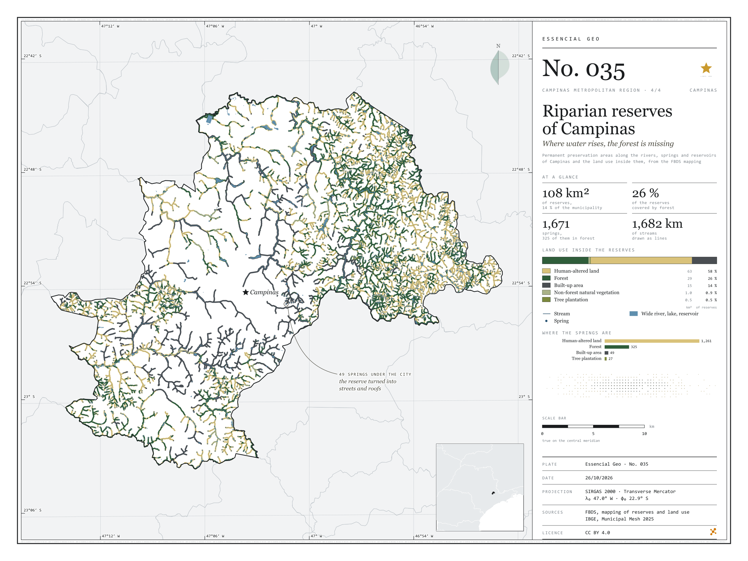
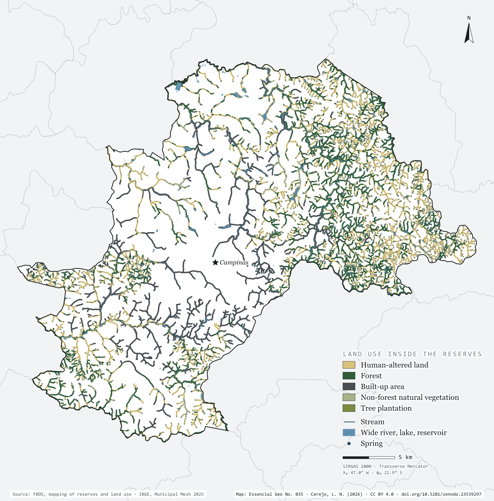
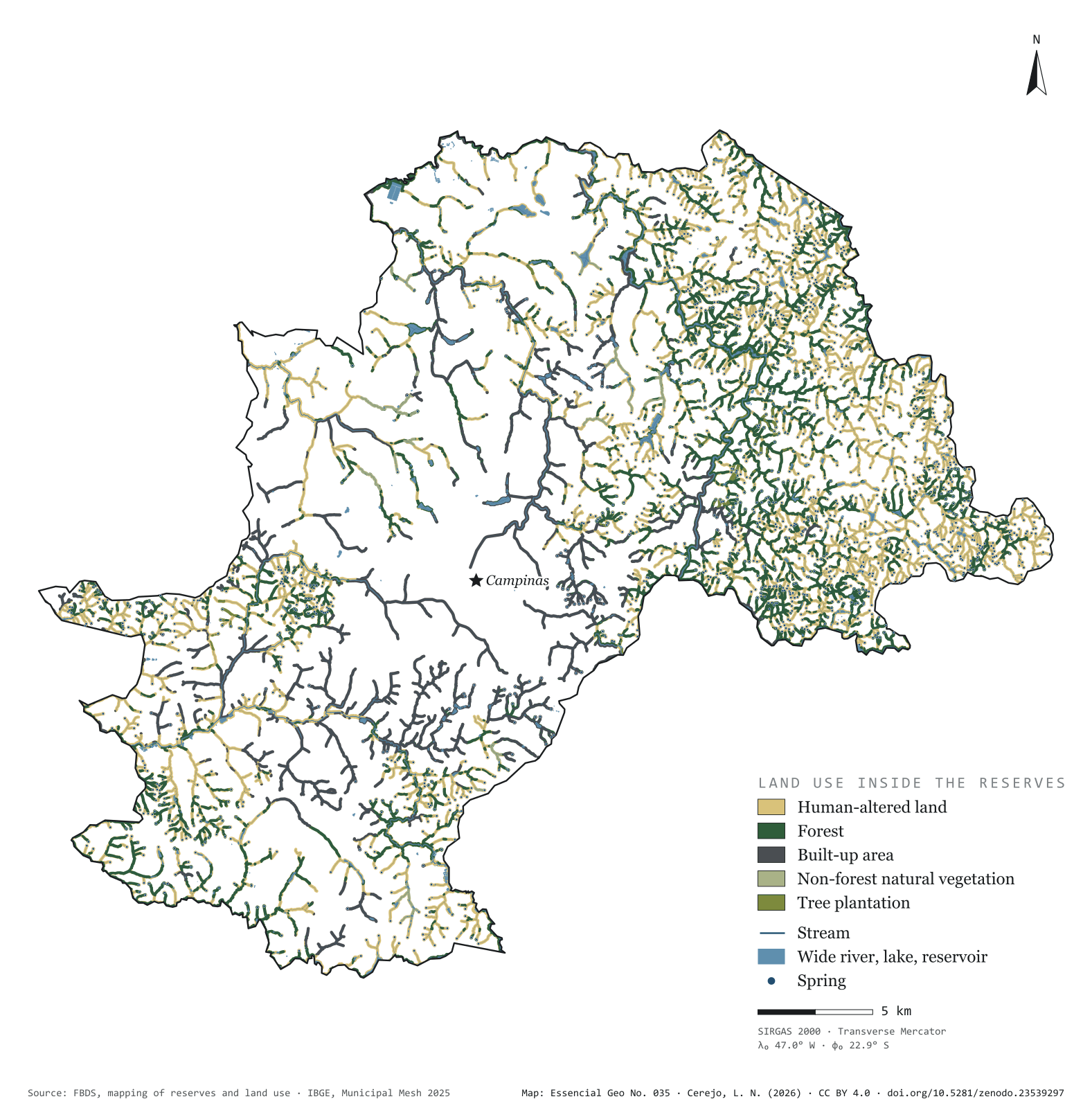
Figure to reuse
The map without a frame, with legend, scale, reference system and credit written on it: ready for papers, lectures and slides. In two versions: with the basemap (neighbours and sea) or only the mapped area, on white.
With basemap (PNG) Without basemap (PNG) QR code (SVG)
Point a camera at it to open this page.
How to cite
CEREJO, Lucas Nakamura. APPs de Campinas: onde a água nasce, a mata falta. Versão 1.0.0. [S. l.]: Zenodo, 2026. Conjunto de dados. DOI: 10.5281/zenodo.23539297. Disponível em: https://doi.org/10.5281/zenodo.23539297. Acesso em: 10 nov. 2026.
Cerejo, L. N. (2026). APPs de Campinas: onde a água nasce, a mata falta [Riparian reserves of Campinas: Where water rises, the forest is missing] (Version 1.0.0) [Data set]. Zenodo. https://doi.org/10.5281/zenodo.23539297
@dataset{cerejo2026_apps_campinas,
  author    = {Cerejo, Lucas Nakamura},
  title     = {APPs de Campinas: Onde a água nasce, a mata falta},
  year      = {2026},
  publisher = {Zenodo},
  version   = {1.0.0},
  doi       = {10.5281/zenodo.23539297},
  url       = {https://doi.org/10.5281/zenodo.23539297},
  language  = {portuguese},
  note      = {English title: Riparian reserves of Campinas: Where water rises, the forest is missing. Licence CC BY 4.0}
}