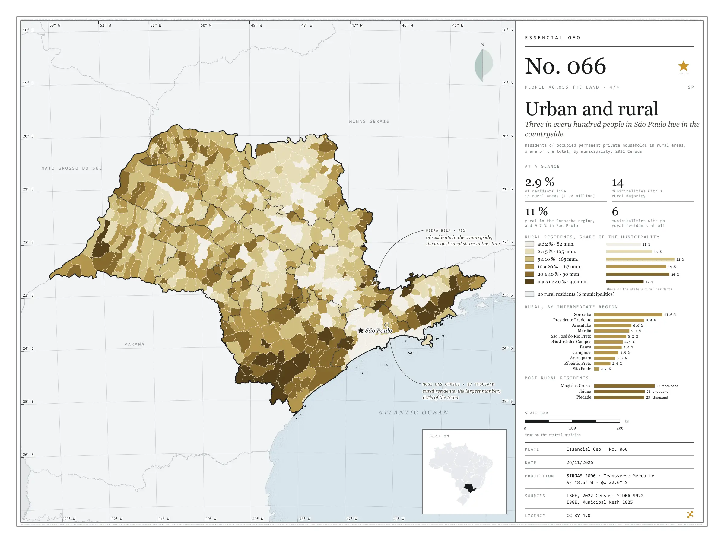
Where people live
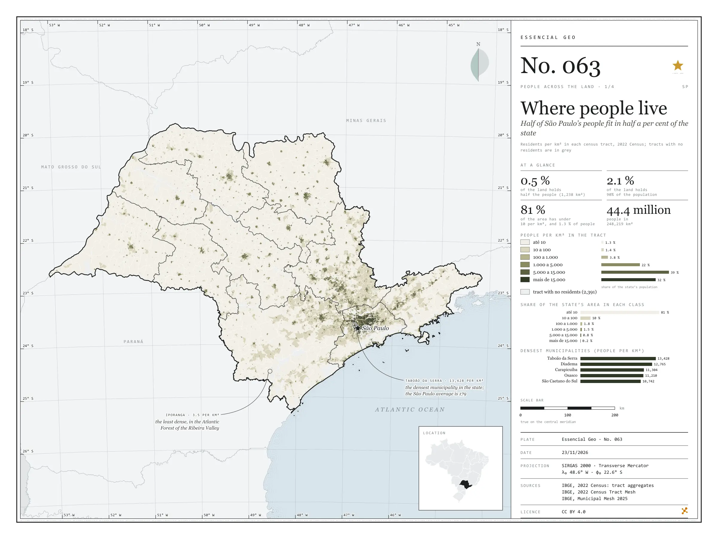
Half of São Paulo’s people fit in half a per cent of the state
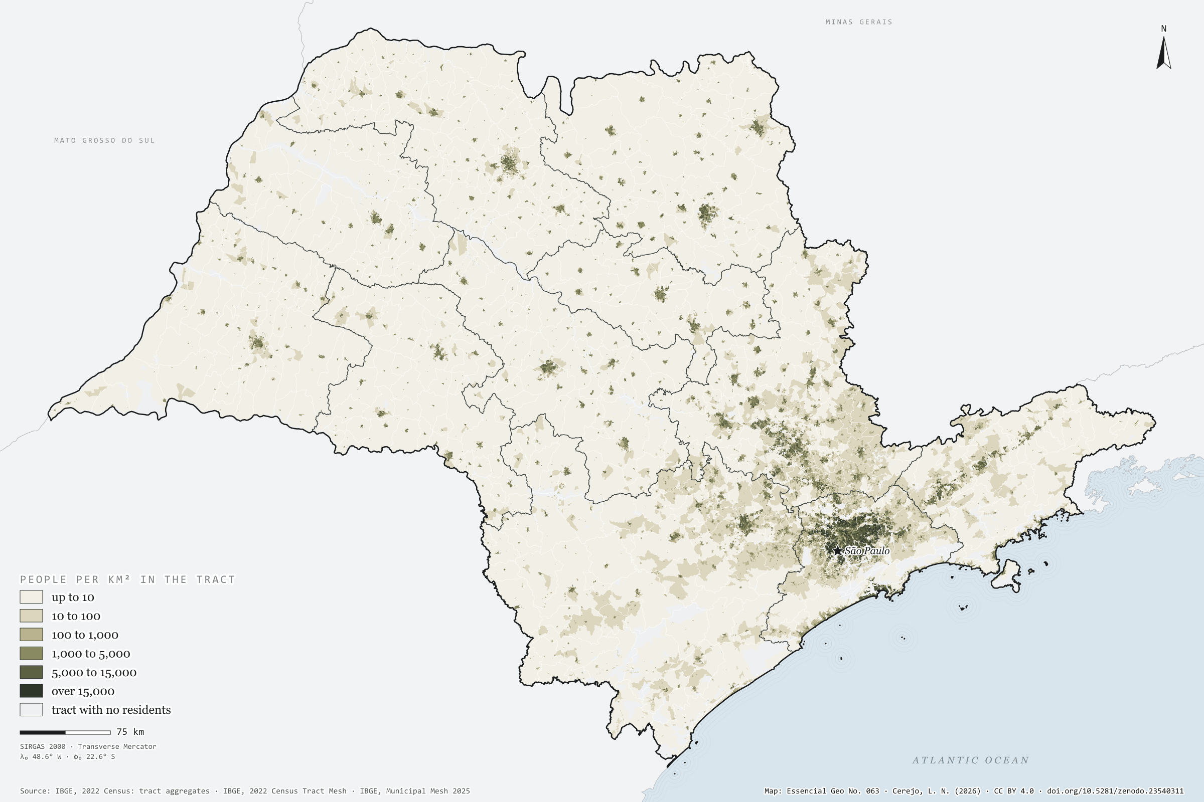
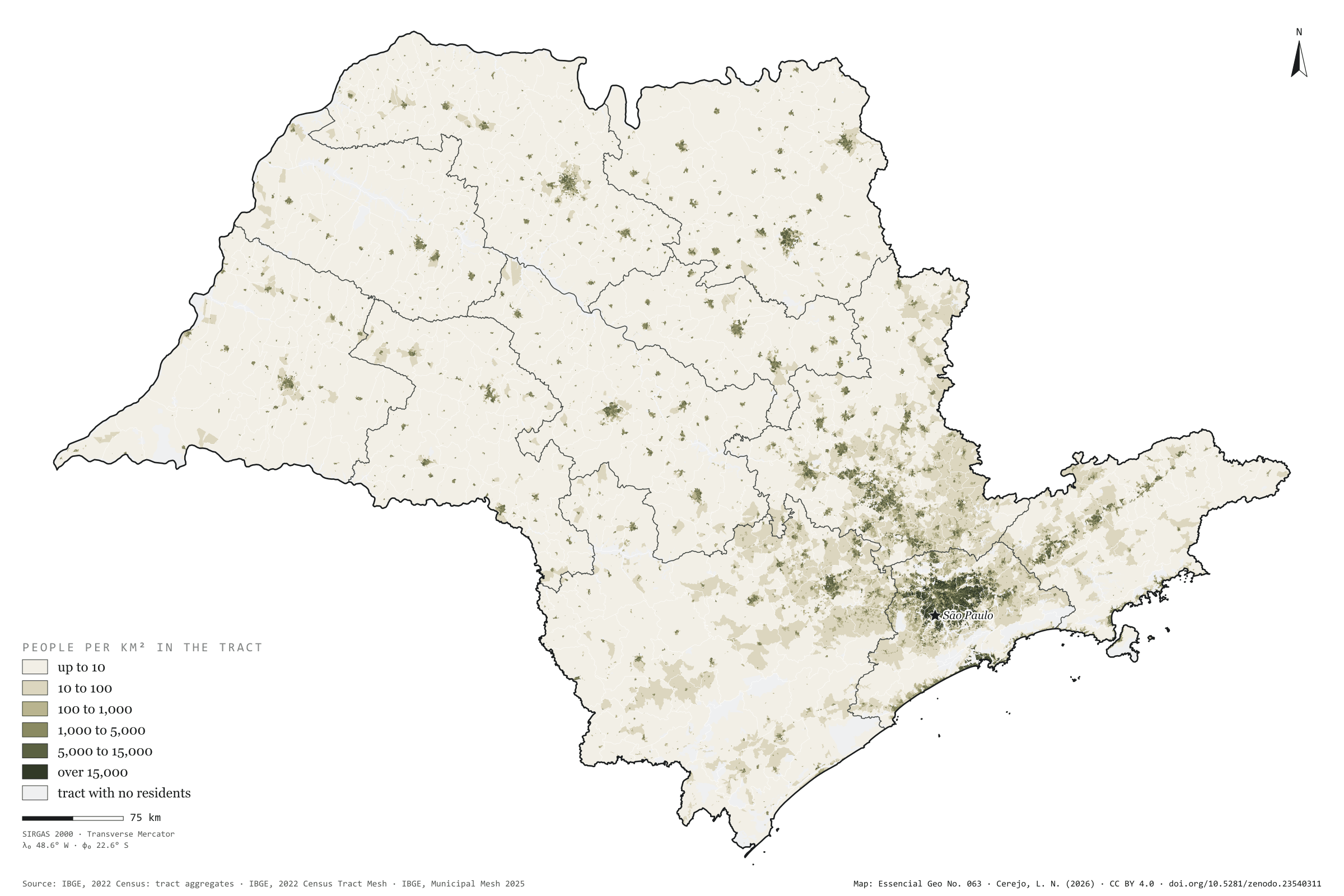
São Paulo has 44.4 million people on 248,000 km², 179 per km² on average. But the average misleads. Half the population lives in census tracts that together cover 1,238 km², 0.5% of the state; 90% live on 2.1%. At the other end, 81% of the area has fewer than 10 residents per km² and holds 1.3% of the people. The map is almost all cream, with dark dots for the towns and one continuous patch in Greater São Paulo, reaching towards Campinas, Sorocaba and the Paraíba Valley. The densest municipality is Taboão da Serra, with 13,428 residents per km², followed by Diadema and Carapicuíba; the capital has 7,521. The least dense is Iporanga, in the Ribeira Valley, with 3.5. First plate of the collection “People across the land”.
Technical record · downloads · citation
At a glance
- up to 10 1.3%
- 10 to 100 1.4%
- 100 to 1,000 3.8%
- 1,000 to 5,000 22.5%
- 5,000 to 15,000 39.4%
- over 15,000 31.6%
0.5 %
179 people per km²
Layers
- setores polygon 103,319 tracts: area, people, residents per km², people by age group and density and 60-plus classes
- regioes_intermediarias polygon 11 intermediate geographic regions
- limite_estadual polygon State boundary
Metadata
- Sources
- IBGE — 2022 Population Census: census tract aggregates (basic characteristics and demography) (2022)
IBGE — 2022 Census Tract Mesh (2022)
IBGE — Municipal Mesh 2025 (2025) - Extent
- São Paulo State (SP)
- CRS / Projection
- SIRGAS 2000 (EPSG:4674)
EPSG:4674 - Software
- Node.js · d3-geo · QGIS
- Method
- Residents per km² of each 2022 Census tract (the tract’s own area), in six classes; share of the state’s population and area in each class; cumulative area of tracts from densest to least dense until they hold half and 90% of the population.
- Version
- v1.0.0
- Licence
- CC BY 4.0
Downloads
- GPKG Census tracts with population, density and age, SIRGAS 2000, with QGIS styles (.gpkg) 26.0 MB
- SVG Vector plate, for printing (.svg) 3.0 MB
- PNG Plate (PNG, 2400 px) (.png) 0.3 MB

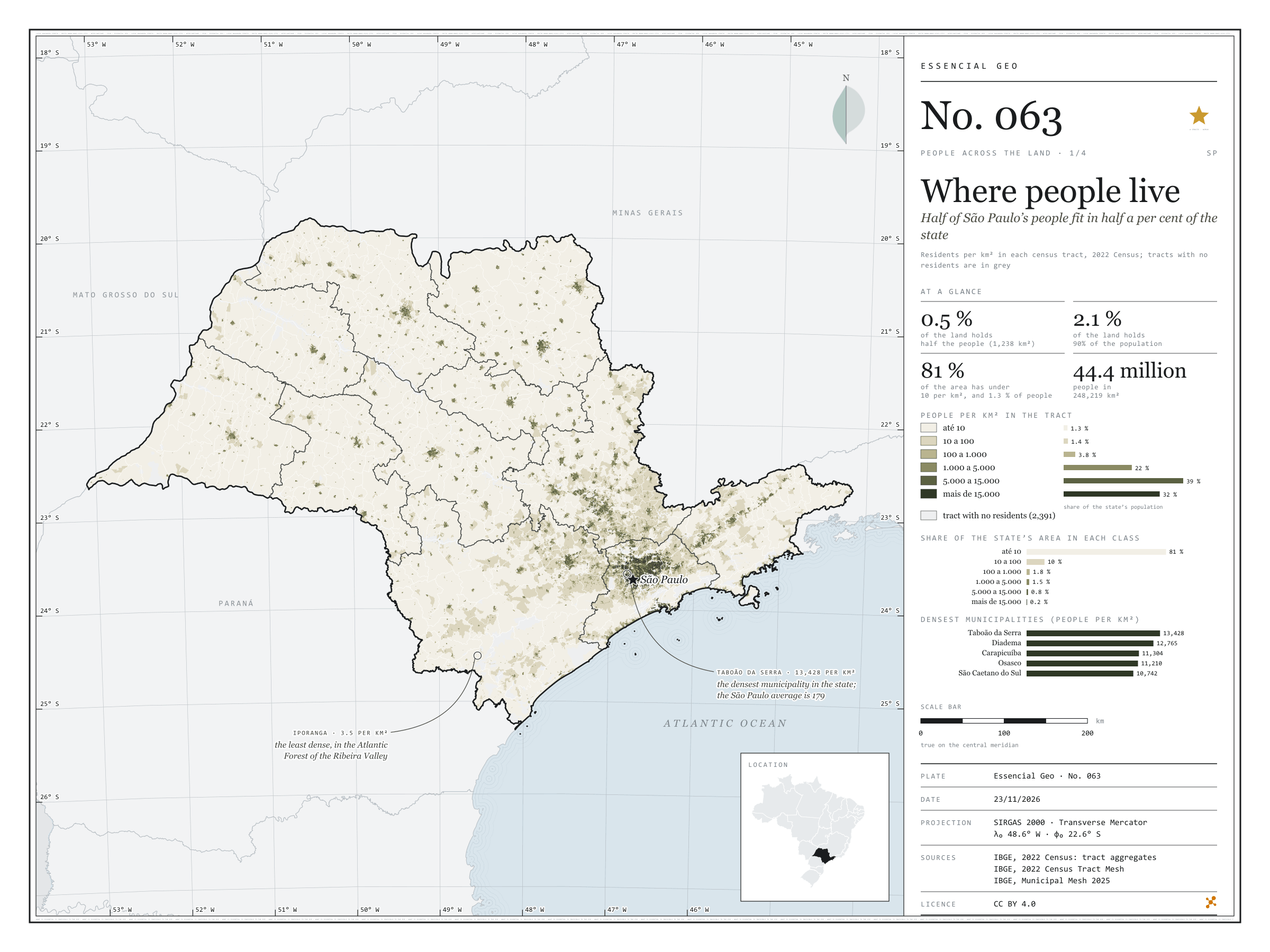
Figure to reuse
The map without a frame, with legend, scale, reference system and credit written on it: ready for papers, lectures and slides. In two versions: with the basemap (neighbours and sea) or only the mapped area, on white.
With basemap (PNG) Without basemap (PNG) QR code (SVG)
Point a camera at it to open this page.
How to cite
CEREJO, Lucas Nakamura. Onde mora a gente: metade dos paulistas cabe em meio por cento do estado. Versão 1.0.0. [S. l.]: Zenodo, 2026. Conjunto de dados. DOI: 10.5281/zenodo.23540311. Disponível em: https://doi.org/10.5281/zenodo.23540311. Acesso em: 10 nov. 2026.
Cerejo, L. N. (2026). Onde mora a gente: metade dos paulistas cabe em meio por cento do estado [Where people live: Half of São Paulo’s people fit in half a per cent of the state] (Version 1.0.0) [Data set]. Zenodo. https://doi.org/10.5281/zenodo.23540311
@dataset{cerejo2026_densidade_sp,
  author    = {Cerejo, Lucas Nakamura},
  title     = {Onde mora a gente: Metade dos paulistas cabe em meio por cento do estado},
  year      = {2026},
  publisher = {Zenodo},
  version   = {1.0.0},
  doi       = {10.5281/zenodo.23540311},
  url       = {https://doi.org/10.5281/zenodo.23540311},
  language  = {portuguese},
  note      = {English title: Where people live: Half of São Paulo’s people fit in half a per cent of the state. Licence CC BY 4.0}
}