Urban and rural
Three in every hundred people in São Paulo live in the countryside
Record, downloads and citationOf the 44.1 million residents of private households in São Paulo, 1.30 million live in rural areas: 2.9%, three in every hundred. The state’s countryside is concentrated in the south and east: in the Sorocaba intermediate region, 11% of residents are rural; in Presidente Prudente, 8%; in São Paulo, 0.7%. The map darkens in the Ribeira Valley and the upper Paranapanema, the Mantiqueira and the Serra do Mar, where towns are small and homes scattered. Pedra Bela, on the border with Minas Gerais, has 73% of its residents in the countryside, and 14 municipalities have a rural majority. In numbers, the largest countryside is Mogi das Cruzes’s, with 27,000 rural residents, ahead of Ibiúna and Piedade; the capital has 16,000. Five municipalities in Greater São Paulo, and Águas de São Pedro, have none. Last plate of the collection “People across the land”.
Technical record · downloads · citation
At a glance
- up to 2% 11.1%
- 2 to 5% 14.8%
- 5 to 10% 22.1%
- 10 to 20% 19.4%
- 20 to 40% 20.5%
- over 40% 12.1%
2.9 %
14 municipalities
Layers
- municipios polygon 645 municipalities: urban and rural households and residents, rural share, age and sex (the same layer as plate 064)
- regioes_intermediarias polygon 11 intermediate geographic regions
- limite_estadual polygon State boundary
Metadata
- Sources
- IBGE — 2022 Population Census: table 9922 (households and residents by urban/rural status) (2022)
IBGE — Municipal Mesh 2025 (2025) - Extent
- São Paulo State (SP)
- CRS / Projection
- SIRGAS 2000 (EPSG:4674)
EPSG:4674 - Software
- Node.js · d3-geo · QGIS
- Method
- Residents of occupied permanent private households in rural areas over all residents of those households, by municipality, from SIDRA 9922, in six classes; municipalities with no rural residents shown apart.
- Version
- v1.0.0
- Licence
- CC BY 4.0
Downloads
- GPKG Municipalities with age, sex and urban/rural status, SIRGAS 2000, with QGIS styles (.gpkg) 4.5 MB
- CSV Municipal table (.csv) 70 kB
- SVG Vector plate, for printing (.svg) 2.2 MB
- PNG Plate (PNG, 2400 px) (.png) 0.3 MB

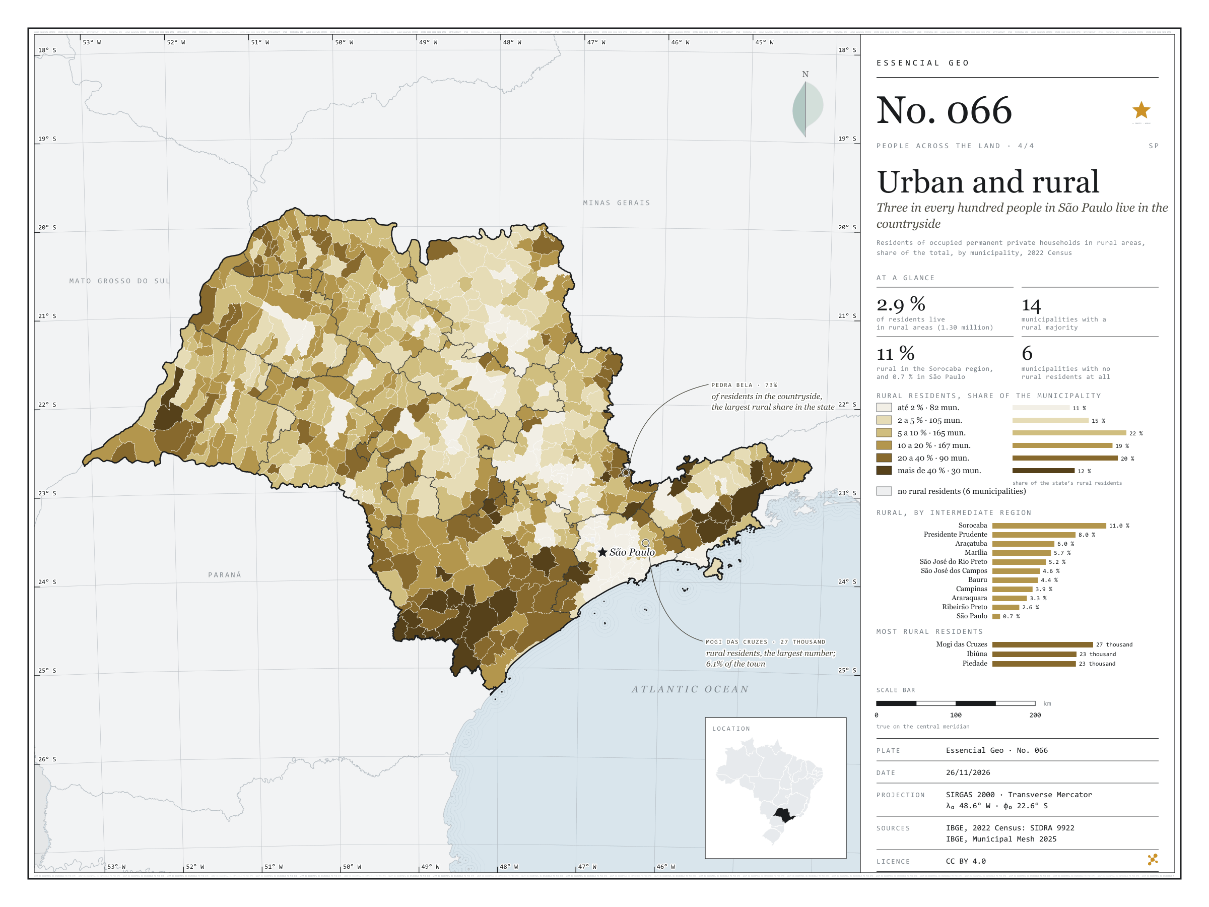
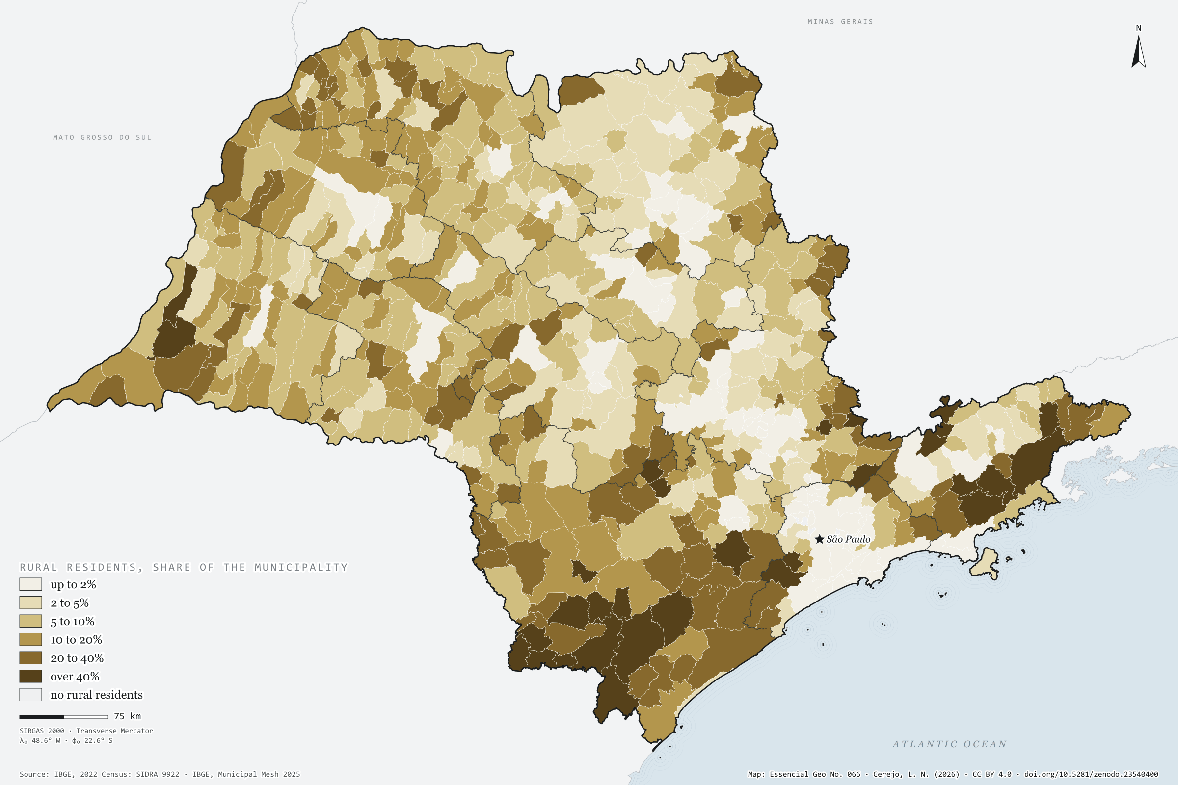
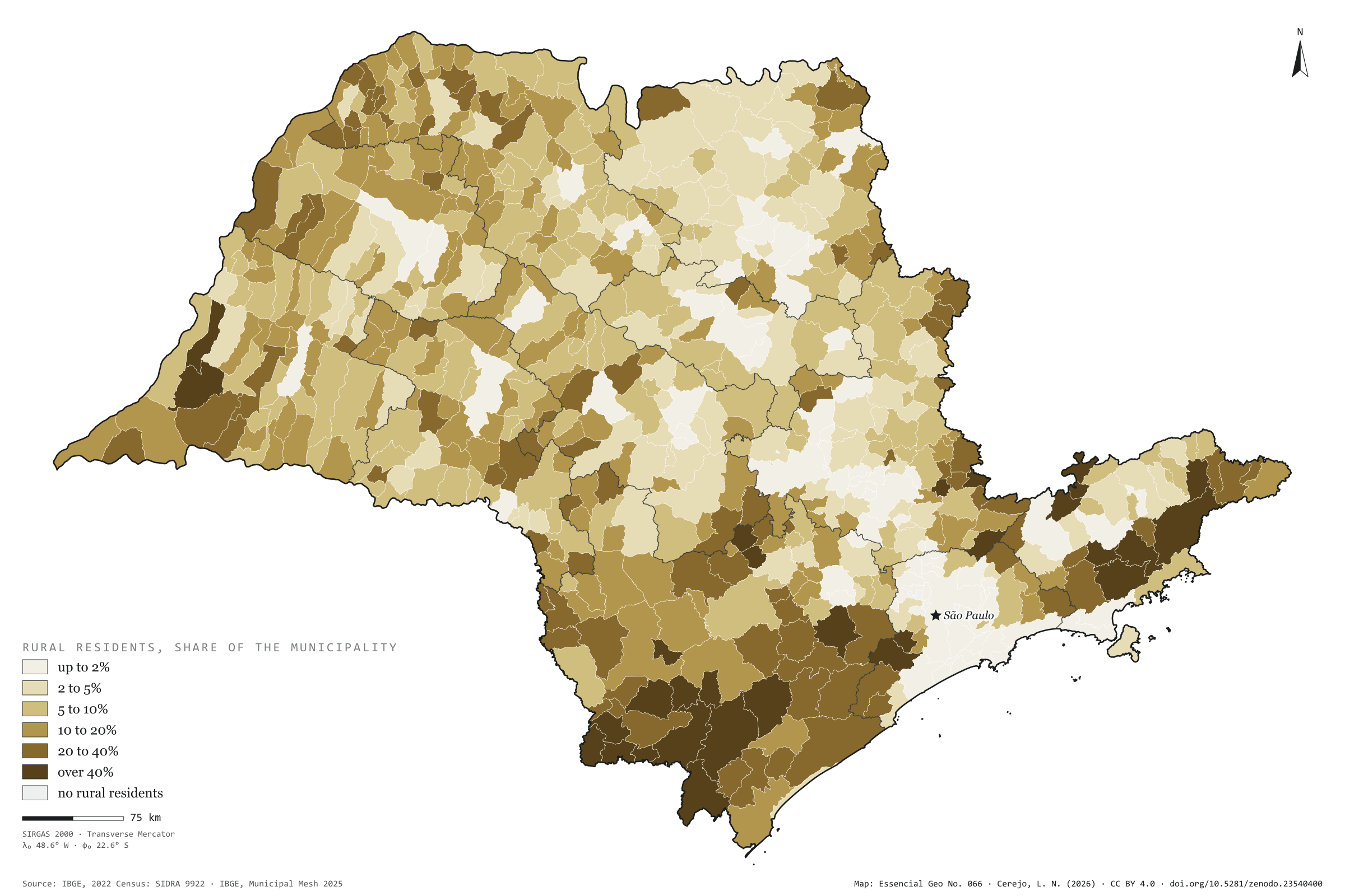
Figure to reuse
The map without a frame, with legend, scale, reference system and credit written on it: ready for papers, lectures and slides. In two versions: with the basemap (neighbours and sea) or only the mapped area, on white.
With basemap (PNG) Without basemap (PNG) QR code (SVG)
Point a camera at it to open this page.
How to cite
CEREJO, Lucas Nakamura. Urbano e rural: três em cada cem paulistas moram no campo. Versão 1.0.0. [S. l.]: Zenodo, 2026. Conjunto de dados. DOI: 10.5281/zenodo.23540400. Disponível em: https://doi.org/10.5281/zenodo.23540400. Acesso em: 10 nov. 2026.
Cerejo, L. N. (2026). Urbano e rural: três em cada cem paulistas moram no campo [Urban and rural: Three in every hundred people in São Paulo live in the countryside] (Version 1.0.0) [Data set]. Zenodo. https://doi.org/10.5281/zenodo.23540400
@dataset{cerejo2026_urbano_e_rural_sp,
  author    = {Cerejo, Lucas Nakamura},
  title     = {Urbano e rural: Três em cada cem paulistas moram no campo},
  year      = {2026},
  publisher = {Zenodo},
  version   = {1.0.0},
  doi       = {10.5281/zenodo.23540400},
  url       = {https://doi.org/10.5281/zenodo.23540400},
  language  = {portuguese},
  note      = {English title: Urban and rural: Three in every hundred people in São Paulo live in the countryside. Licence CC BY 4.0}
}