River basins
Twenty-two homes for the same rain
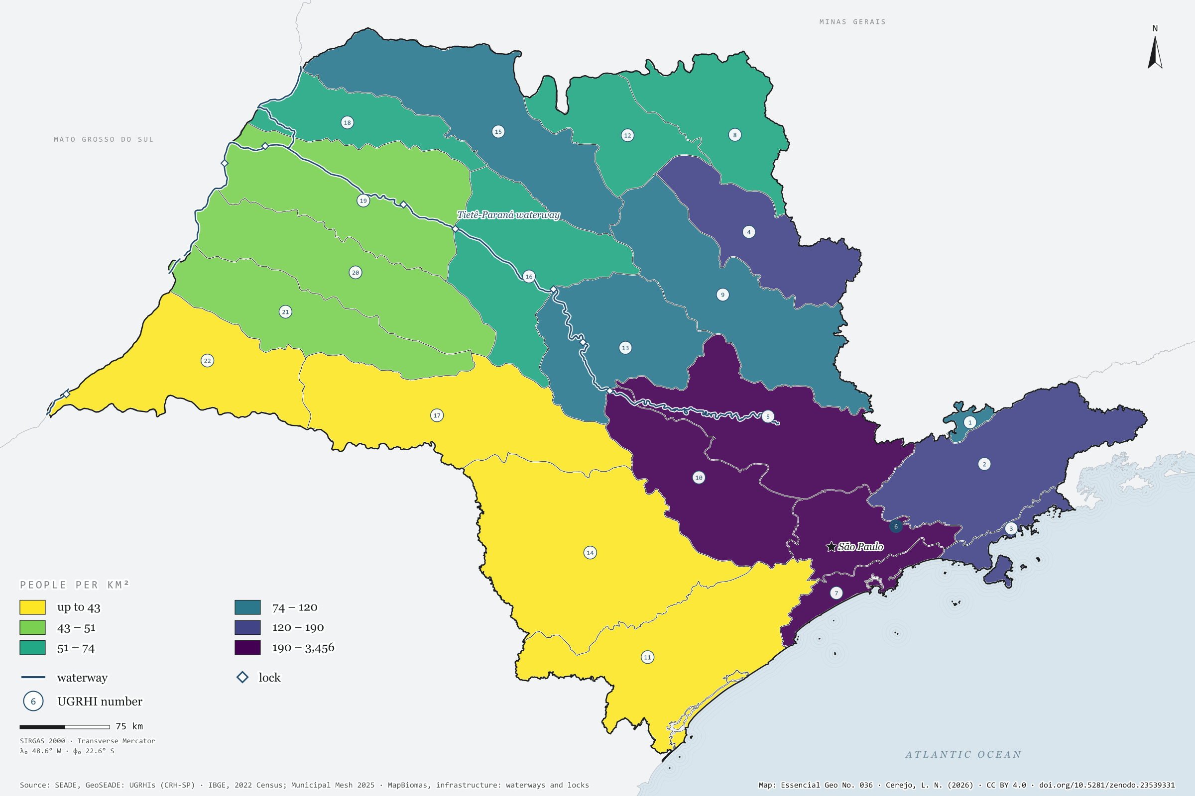
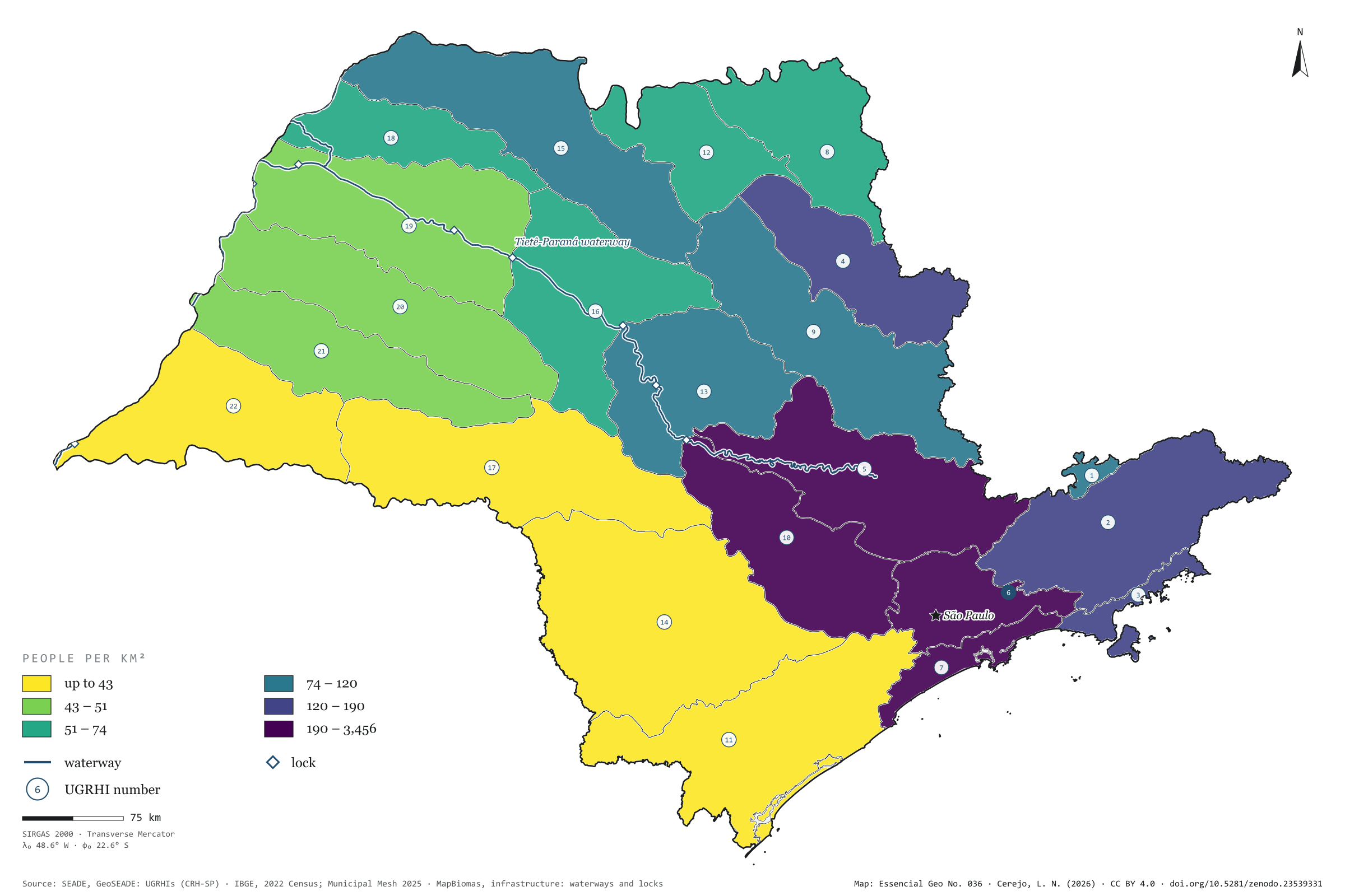
Record, downloads and citationTo look after its water, São Paulo does not use the map of municipalities but the map of basins: 22 Water Resources Management Units, the UGRHIs. Coloured by the 2022 Census population, they show a state that is unequal under the same rain. The municipalities of Alto Tietê, around the capital, hold 20.5 million people, 46.1% of the state’s population, on 2.4% of its land: 3,456 people per km². In Pontal do Paranapanema there are 20.8. Along the Tietê and the Paraná runs the waterway too, with its eight locks drawn on the map. First plate of the collection “Water in São Paulo”.
Technical record · downloads · citation
At a glance
3,456 people/km²
Layers
- ugrhi polygon 22 UGRHIs: area, municipalities, 2022 population and density
- municipios polygon 645 municipalities, with the assigned UGRHI, the share of territory in it and the 2022 population
- hidrovia line Tietê-Paraná waterway
- eclusas point 8 locks on the waterway
- limite_estadual polygon State boundary
Metadata
- Sources
- SEADE — GeoSEADE: Water Resources Management Units (UGRHIs), as defined by the State Water Resources Council
IBGE — 2022 Population Census: aggregates by municipality (2022)
MapBiomas — infrastructure database: waterways and locks
IBGE — Municipal Mesh 2025 (2025) - Extent
- São Paulo state (SP)
- CRS / Projection
- SIRGAS 2000 (EPSG:4674)
EPSG:4674 - Software
- Python · GeoPandas · GDAL · QGIS · Node.js · d3-geo
- Method
- Each municipality assigned to the UGRHI covering most of its territory; 2022 Census population summed by UGRHI and divided by basin area, in six quantile classes.
- Version
- v1.0.0
- Licence
- CC BY 4.0
Downloads
- GPKG Five layers, SIRGAS 2000, with QGIS styles (.gpkg) 16.4 MB
- CSV The 22 UGRHIs: area, municipalities, population and density (.csv) 1 kB
- SVG Vector plate, for printing (.svg) 2.3 MB
- PNG Plate (PNG, 2400 px) (.png) 0.3 MB

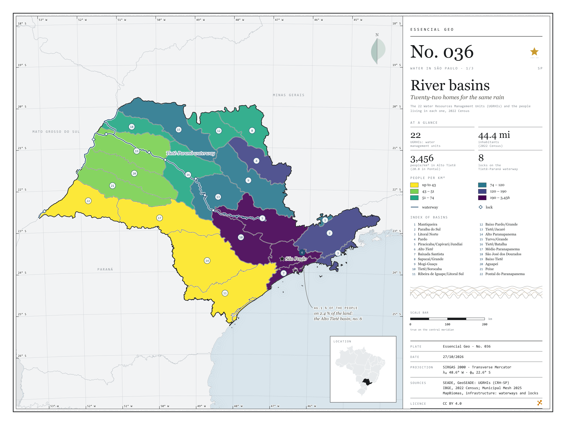
Figure to reuse
The map without a frame, with legend, scale, reference system and credit written on it: ready for papers, lectures and slides. In two versions: with the basemap (neighbours and sea) or only the mapped area, on white.
With basemap (PNG) Without basemap (PNG) QR code (SVG)
Point a camera at it to open this page.
How to cite
CEREJO, Lucas Nakamura. Bacias hidrográficas: vinte e duas casas para a mesma chuva. Versão 1.0.0. [S. l.]: Zenodo, 2026. Conjunto de dados. DOI: 10.5281/zenodo.23539331. Disponível em: https://doi.org/10.5281/zenodo.23539331. Acesso em: 10 nov. 2026.
Cerejo, L. N. (2026). Bacias hidrográficas: vinte e duas casas para a mesma chuva [River basins: Twenty-two homes for the same rain] (Version 1.0.0) [Data set]. Zenodo. https://doi.org/10.5281/zenodo.23539331
@dataset{cerejo2026_bacias_hidrograficas_sp,
  author    = {Cerejo, Lucas Nakamura},
  title     = {Bacias hidrográficas: Vinte e duas casas para a mesma chuva},
  year      = {2026},
  publisher = {Zenodo},
  version   = {1.0.0},
  doi       = {10.5281/zenodo.23539331},
  url       = {https://doi.org/10.5281/zenodo.23539331},
  language  = {portuguese},
  note      = {English title: River basins: Twenty-two homes for the same rain. Licence CC BY 4.0}
}