Skip to content
Essencial

No. 007 Territorial divisions Brazil, state by state 7/27

Rio Grande do Sul

Territorial divisions and highways

Record, downloads and citation
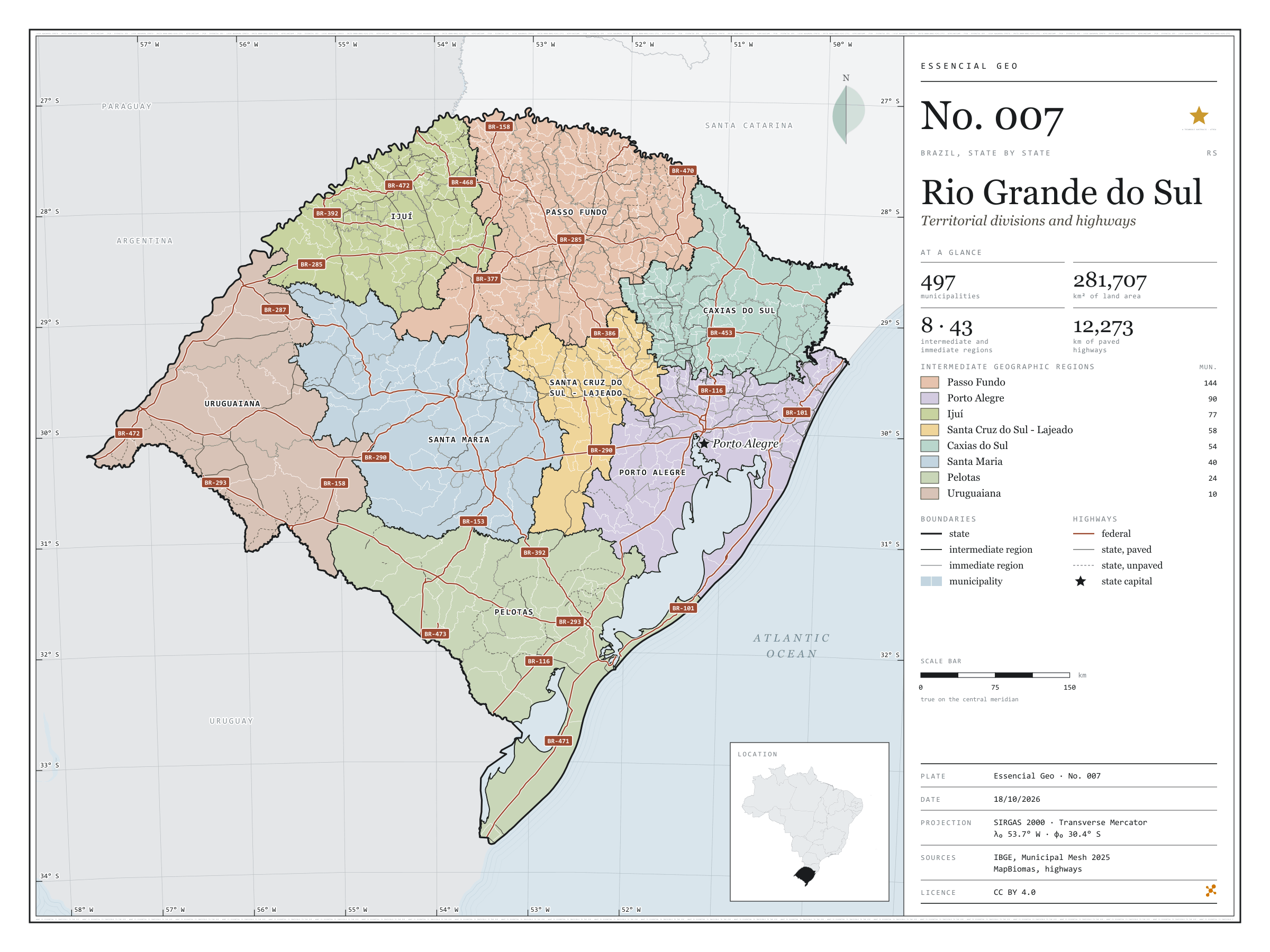
Fig. 007 Rio Grande do Sul state (RS) EPSG:4674 Source: IBGE, MapBiomas, Natural Earth

Rio Grande do Sul has 497 municipalities across 282,000 km², 3.3 per cent of Brazil. IBGE groups them into 43 immediate regions, drawn around the towns that supply jobs, trade and services to their surroundings, and into 8 intermediate regions that tie those networks together. Passo Fundo is the intermediate region with the most municipalities (144); Uruguaiana, the one with the fewest (10). The largest municipality is Alegrete (7,801 km²); the smallest, Esteio (28 km²). Part of the series “Brazil, state by state”: a clean base, with official boundaries and the road network, to start a map without losing the first afternoon gathering files.

Technical record · downloads · citation

At a glance

Municipalities per intermediate region (municipalities)
  • Passo Fundo 144
  • Porto Alegre 90
  • Ijuí 77
  • Santa Cruz do Sul - Lajeado 58
  • Caxias do Sul 54
  • Santa Maria 40
  • Pelotas 24
  • Uruguaiana 10
Area

281,707 km²

Largest municipality: Alegrete (7,801 km²); smallest: Esteio (28 km²)

Paved highways

12,273 km

5,906 km federal and 10,026 km state highways, paved or not

Layers

  • municipios polygon 497 municipalities, with IBGE code, regions, urban concentration and area (km²)
  • regioes_intermediarias polygon 8 intermediate geographic regions
  • regioes_imediatas polygon 43 immediate geographic regions
  • limite_estadual polygon Boundary of the federative unit
  • rodovias line Federal and state highways: route number, surface, physical status, carriageways
  • capital point Indicative point for the capital (not the exact seat)

Metadata

Extent
Rio Grande do Sul state (RS)
CRS / Projection
SIRGAS 2000 (EPSG:4674)
EPSG:4674
Software
Python · GeoPandas · GDAL · QGIS · Node.js · d3-geo
Method
IBGE Municipal Mesh boundaries, dissolved into immediate and intermediate regions and the unit boundary; highways clipped to the unit.
Version
v1.0.0
Licence
CC BY 4.0

Downloads

Figure to reuse

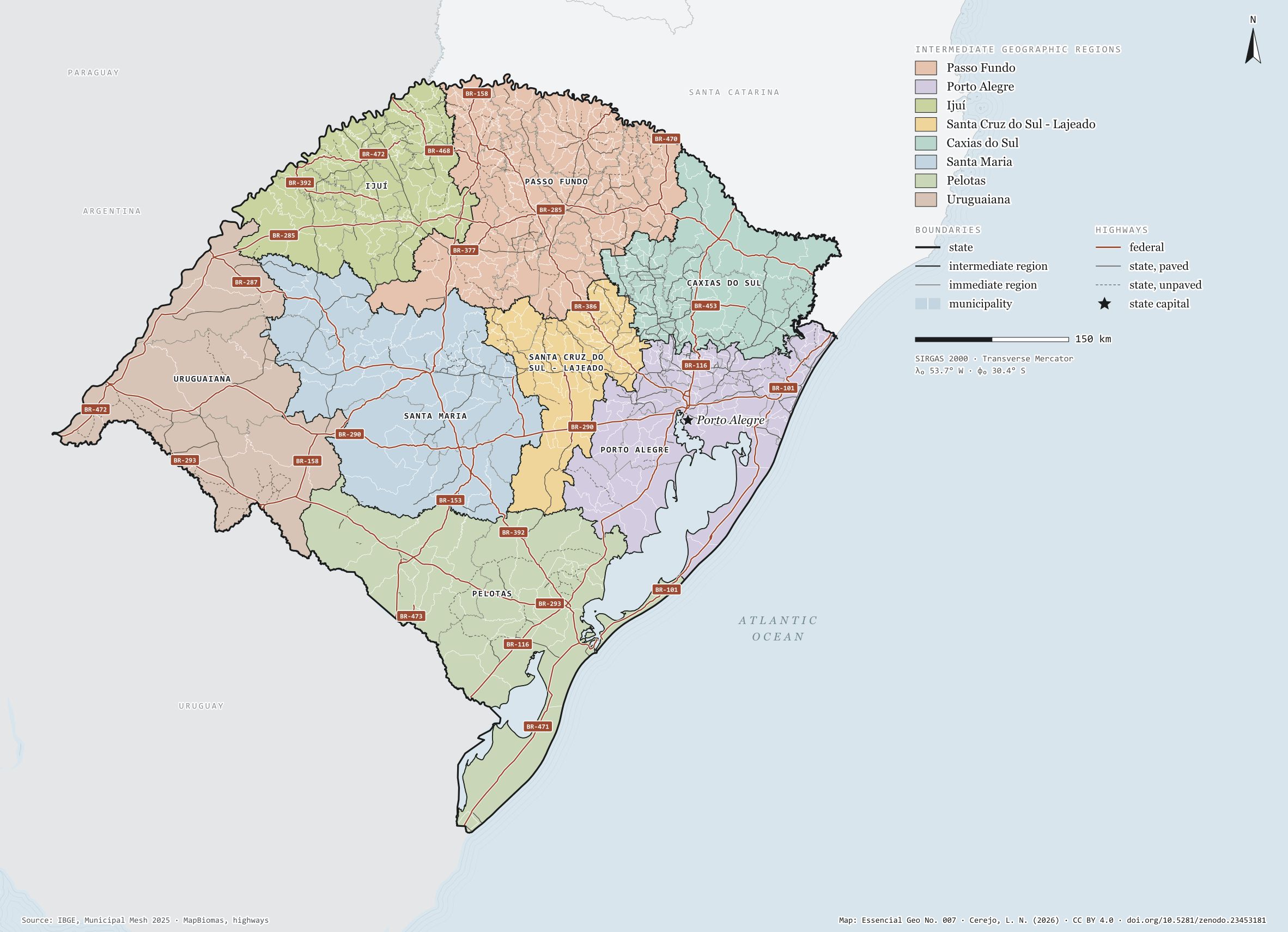
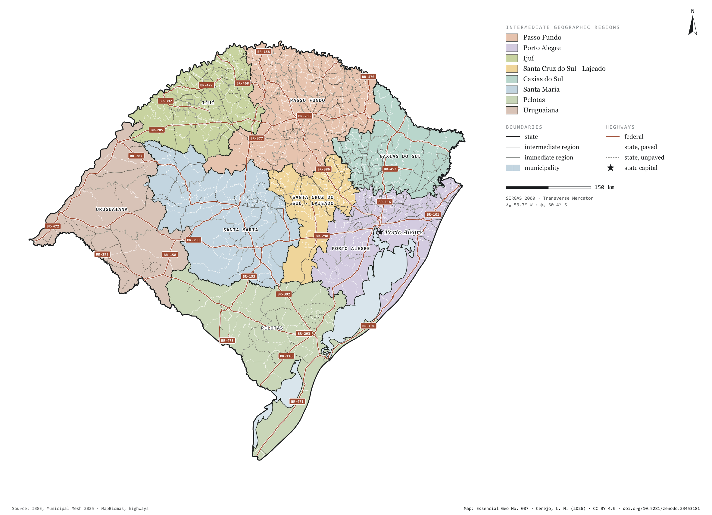
The map without a frame, with legend, scale, reference system and credit written on it: ready for papers, lectures and slides. In two versions: with the basemap (neighbours and sea) or only the mapped area, on white.

Point a camera at it to open this page.

How to cite

Cerejo, L. N. (2026). Rio Grande do Sul: divisão territorial e rodovias [Rio Grande do Sul: Territorial divisions and highways] (Version 1.0.0) [Data set]. Zenodo. https://doi.org/10.5281/zenodo.23453181

How to read this plate area, projection, scale, legend and source
1 Area
Rio Grande do Sul state (RS) The area the plate covers. Outside it, neighbours and sea are drawn in grey, just for orientation.
2 Coordinates and projection
SIRGAS 2000 (EPSG:4674) The layers are in SIRGAS 2000; the drawing’s projection is written in the colophon at the foot of the panel.
3 Scale
Graphic scale bar in the panel The scale bar is true on the central meridian; away from it, measured distances vary a little.
4 Legend and layers
6 layers in the GeoPackage · polygon, line, point Read the legend before the map: it tells you whether a colour is a rate or a class, and whether a circle is a total.
5 Sources
IBGE (2025); IBGE (2017); MapBiomas; Natural Earth Every figure comes from a public source, with its year. The data sheet gives each one’s address.

Download

Layers, table and figures, under CC BY 4.0. Cite with the DOI.

Full record and citation

Method notes · No. 007

Rio Grande do Sul — territorial divisions and highways

Português · English

Plate No. 007 of the series Brazil, state by state: a cartographic base for each of the 27 federative units, with the same files, the same layers and the same design, ready to download and get to work.

The IBGE mesh includes Lagoa Mirim and Lagoa dos Patos as “operational areas”: they count towards the state boundary and area (13,084 km²) but are not municipalities and belong to no region. They have their own layer, areas_operacionais, and appear as water on the plate.

What the files contain

Layer (GPKG)GeometryContents
municipiospolygon497 municipalities: CD_MUN, NM_MUN, immediate and intermediate regions, urban concentration, area_km2, capital
regioes_intermediariaspolygon8 regions, with their number of municipalities
regioes_imediataspolygon43 regions, with their number of municipalities
limite_estadualpolygonoutline of the unit
rodoviaslinefederal and state highways: sigla, revestimento, situacao_fisica, n_pistas, pavimentada
capitalpointindicative point inside the municipality (not the seat)
areas_operacionaispolygonLagoa Mirim and Lagoa dos Patos, with area_km2

The GPKG is zipped and attached to the repository’s estados-2025 release, together with those of the other 26 units.

The GPKG carries its own QGIS styles, saved as each layer’s default style: drag the file into QGIS and the municipalities appear in the colours of their intermediate regions, boundaries and highways with the plate’s strokes, and names with a halo. Highway sections without a confirmed physical status sit in a legend rule that is switched off, as on the plate; tick it to see them. Other GIS software opens the layers as usual, without the style. To match the plate, stack them from top to bottom: capital, rodovias, limite_estadual, regioes_intermediarias, regioes_imediatas, areas_operacionais and municipios.

The CSV holds the municipal table in UTF-8, ready to join with Census data or any dataset keyed on the seven-digit IBGE code.

Method

  1. IBGE Municipal Mesh 2025, with geometry unchanged in the downloadable files.
  2. Immediate and intermediate regions and the boundary are dissolved from the municipalities, so their edges match exactly.
  3. Federal and state highways from MapBiomas’ infrastructure base, clipped to the boundary. The plate shows built sections only.
  4. Areas in km² as computed by IBGE; the total matches an Albers calculation (281,707.2 km²).
  5. On the plate, geometries are simplified as a coverage (≈ 400 m), so the unit, its neighbours and the coastline share the same edges.

Limitations

  • The rodovias layer has an incomplete n_pistas field; do not use it to measure dual-carriageway length.
  • The capital point is indicative (an interior point of the municipal polygon).

View this map’s folder on GitHub

Technical record

Technical record · No. 007

Rio Grande do Sul

At a glance

Municipalities per intermediate region (municipalities)
  • Passo Fundo 144
  • Porto Alegre 90
  • Ijuí 77
  • Santa Cruz do Sul - Lajeado 58
  • Caxias do Sul 54
  • Santa Maria 40
  • Pelotas 24
  • Uruguaiana 10
Area

281,707 km²

Largest municipality: Alegrete (7,801 km²); smallest: Esteio (28 km²)

Paved highways

12,273 km

5,906 km federal and 10,026 km state highways, paved or not

Layers

  • municipios polygon 497 municipalities, with IBGE code, regions, urban concentration and area (km²)
  • regioes_intermediarias polygon 8 intermediate geographic regions
  • regioes_imediatas polygon 43 immediate geographic regions
  • limite_estadual polygon Boundary of the federative unit
  • rodovias line Federal and state highways: route number, surface, physical status, carriageways
  • capital point Indicative point for the capital (not the exact seat)

Metadata

Extent
Rio Grande do Sul state (RS)
CRS / Projection
SIRGAS 2000 (EPSG:4674)
EPSG:4674
Software
Python · GeoPandas · GDAL · QGIS · Node.js · d3-geo
Method
IBGE Municipal Mesh boundaries, dissolved into immediate and intermediate regions and the unit boundary; highways clipped to the unit.
Version
v1.0.0
Licence
CC BY 4.0

Downloads

Figure to reuse

The map without a frame, with legend, scale, reference system and credit written on it: ready for papers, lectures and slides. In two versions: with the basemap (neighbours and sea) or only the mapped area, on white.

Point a camera at it to open this page.

How to cite

Cerejo, L. N. (2026). Rio Grande do Sul: divisão territorial e rodovias [Rio Grande do Sul: Territorial divisions and highways] (Version 1.0.0) [Data set]. Zenodo. https://doi.org/10.5281/zenodo.23453181

100%