Skip to content
Essencial

No. 069 Census · income Favelas and urban communities 3/4

The favela street

No street light at the door: 15% in São Paulo’s favelas, 9% in Brazil’s

Record, downloads and citation
Fig. 069 São Paulo State (SP) EPSG:4674 Source: IBGE

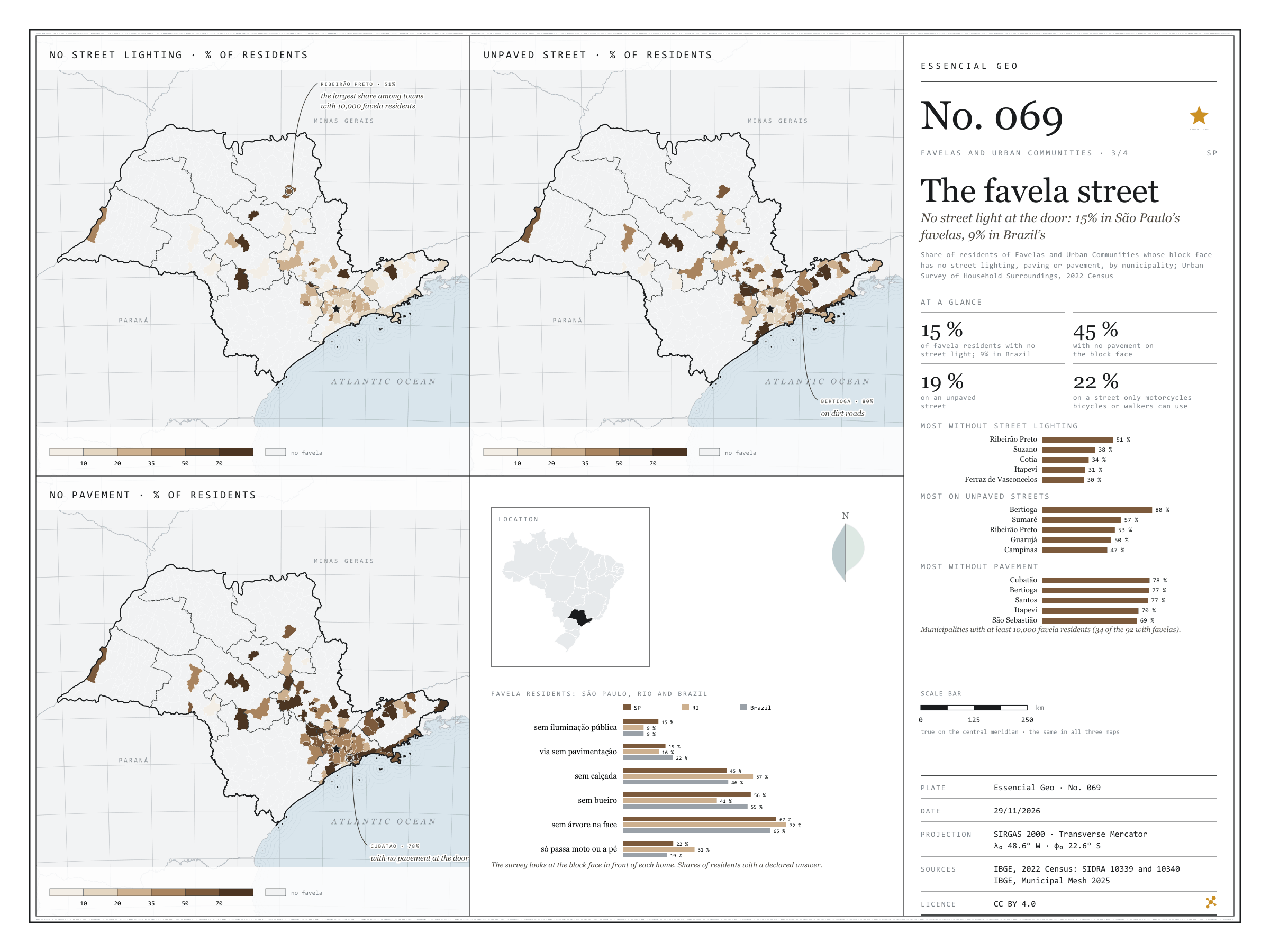
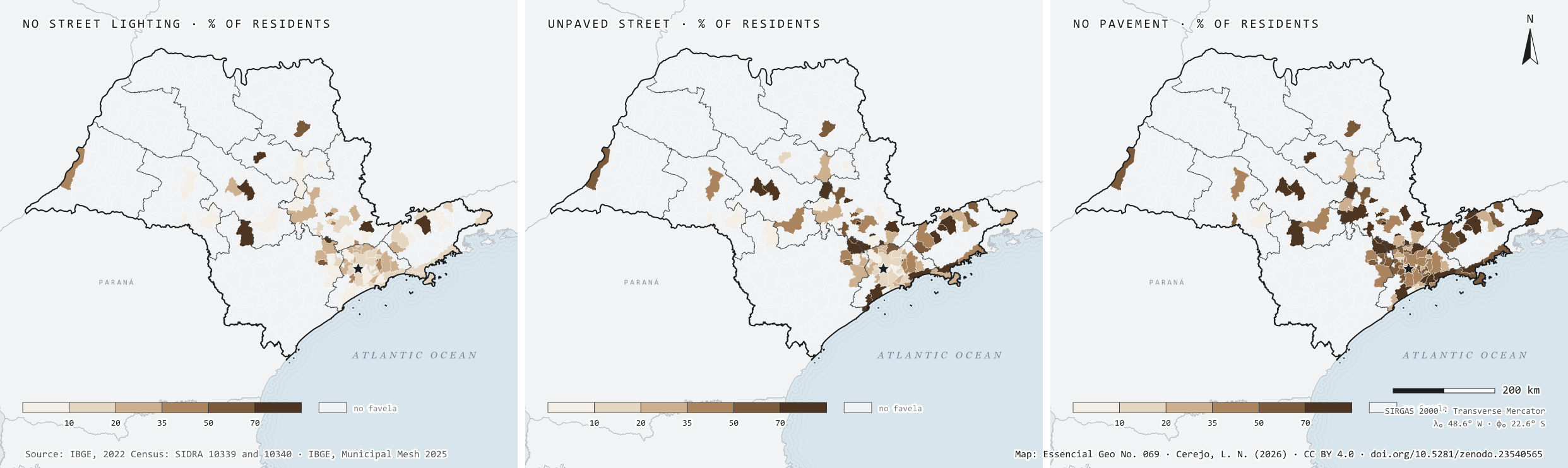
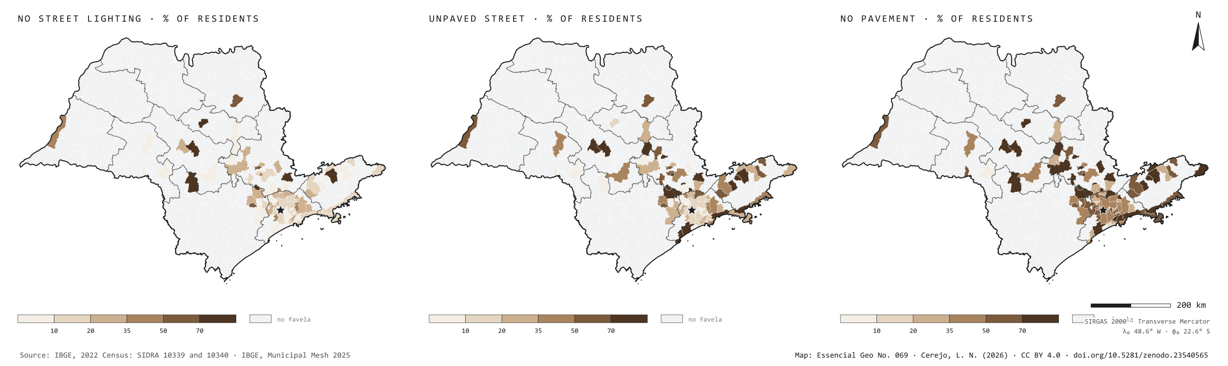
In the 2022 Census, the Urban Survey of Household Surroundings looked at the block face in front of each home. In São Paulo’s favelas, 15% of residents have no street lighting at the door, against 9% in the favelas of Rio and of Brazil as a whole. Paving is better than average: 19% live on an unpaved street, against 22% in Brazil. But 45% have no pavement to walk on, 56% no storm drain and 67% not a single tree on the block face, and for 22% the street only lets through motorbikes, bicycles or people on foot. Among the 34 municipalities with at least 10,000 favela residents, Ribeirão Preto leads on missing light, with 51% of residents in the dark; Bertioga on dirt roads, with 80%; and Cubatão on missing pavements, with 78%, ahead of Bertioga and Santos. The three maps share one frame: only the 92 municipalities with favelas.

Technical record · downloads · citation

At a glance

Favela residents with no street lighting on their block face

15 %

8.9% in Brazil and in Rio de Janeiro

Favela residents with no pavement

45 %

46.1% in Brazil

Favela residents on unpaved streets

19 %

21.7% in Brazil

Layers

  • municipios polygon 645 municipalities: favela residents with surveyed surroundings and the shares without street lighting, paving, storm drains, pavement and trees, and on streets for motorbikes or pedestrians only
  • setores_fcu polygon 8,008 tracts in Favelas and Urban Communities
  • regioes_intermediarias polygon 11 intermediate geographic regions
  • limite_estadual polygon State boundary

Metadata

Extent
São Paulo State (SP)
CRS / Projection
SIRGAS 2000 (EPSG:4674)
EPSG:4674
Software
Node.js · d3-geo · QGIS
Method
Residents of Favelas and Urban Communities whose block face has no street lighting, paving or pavement over residents with the feature declared, by municipality, from SIDRA 10340, in six classes; municipalities without favelas shown apart.
Version
v1.0.0
Licence
CC BY 4.0

Downloads

Figure to reuse

The map without a frame, with legend, scale, reference system and credit written on it: ready for papers, lectures and slides. In two versions: with the basemap (neighbours and sea) or only the mapped area, on white.

Point a camera at it to open this page.

How to cite

Cerejo, L. N. (2026). A rua da favela: sem luz pública na porta: 15 % nas favelas paulistas, 9 % nas do país [The favela street: No street light at the door: 15% in São Paulo’s favelas, 9% in Brazil’s] (Version 1.0.0) [Data set]. Zenodo. https://doi.org/10.5281/zenodo.23540565

How to read this plate area, projection, scale, legend and source · 2 terms
1 Area
São Paulo State (SP) The area the plate covers. Outside it, neighbours and sea are drawn in grey, just for orientation.
2 Coordinates and projection
SIRGAS 2000 (EPSG:4674) The layers are in SIRGAS 2000; the drawing’s projection is written in the colophon at the foot of the panel.
3 Scale
Graphic scale bar in the panel The scale bar is true on the central meridian; away from it, measured distances vary a little.
4 Legend and layers
4 layers in the GeoPackage · polygon Read the legend before the map: it tells you whether a colour is a rate or a class, and whether a circle is a total.
5 Sources
IBGE (2022); IBGE (2025) Every figure comes from a public source, with its year. The data sheet gives each one’s address.

Terms on this plate

Favelas and urban communities
The name IBGE adopted in 2024 in place of “subnormal agglomerations”: low-income housing areas with insecure tenure and incomplete public services.
2022 Census
IBGE’s door-to-door count. Results by census tract give residents, age, household-head income, water, sewerage and rubbish.

Download

Layers, table and figures, under CC BY 4.0. Cite with the DOI.

Full record and citation

Method notes · No. 069

Street lighting, paving and pavements in São Paulo’s favelas

Português · English

Plate No. 069, the third of four in the collection Favelas and urban communities. The favelas, municipality by municipality, are on plate 067.

What the files contain

Layer (GPKG)GeometryContent
municipiospolygon645 municipalities: moradores_entorno (favela residents with surveyed surroundings), sem_iluminacao, sem_pavimentacao, sem_calcada, sem_bueiro, sem_arvores, via_so_moto_pedestre (in %), plus pct_fcu and income
setores_fcupolygon8,008 tracts in favelas
regioes_intermediarias, limite_estadualpolygonreference

It is the GPKG of plate 067, with the QGIS styles sem_iluminacao, sem_pavimentacao and sem_calcada. The CSV has the municipal table, without geometry.

Method

  1. SIDRA 10340: residents of occupied permanent private households in Favelas and Urban Communities, by whether each feature exists on the block face, in each municipality. Table 10339 gives the same figures for the state, Rio de Janeiro and Brazil.
  2. Share without the feature = residents without it over residents with an answer (exists or does not); undeclared cases are left out.
  3. Six classes closed on the right: up to 10%, 10 to 20%, 20 to 35%, 35 to 50%, 50 to 70% and over 70%. The panel’s bars list only the 34 municipalities with at least 10,000 favela residents.

Limitations

  • The survey looks only at the home’s block face: a lamp post on the corner, across the street, does not count.
  • In municipalities with few favela residents, a single community decides the colour; hence the panel’s lists keep to those with 10,000 or more.
  • The features describe the street, not the home; each household’s water, sewage and rubbish are on plate 070.

View this map’s folder on GitHub

Technical record

Technical record · No. 069

The favela street

At a glance

Favela residents with no street lighting on their block face

15 %

8.9% in Brazil and in Rio de Janeiro

Favela residents with no pavement

45 %

46.1% in Brazil

Favela residents on unpaved streets

19 %

21.7% in Brazil

Layers

  • municipios polygon 645 municipalities: favela residents with surveyed surroundings and the shares without street lighting, paving, storm drains, pavement and trees, and on streets for motorbikes or pedestrians only
  • setores_fcu polygon 8,008 tracts in Favelas and Urban Communities
  • regioes_intermediarias polygon 11 intermediate geographic regions
  • limite_estadual polygon State boundary

Metadata

Extent
São Paulo State (SP)
CRS / Projection
SIRGAS 2000 (EPSG:4674)
EPSG:4674
Software
Node.js · d3-geo · QGIS
Method
Residents of Favelas and Urban Communities whose block face has no street lighting, paving or pavement over residents with the feature declared, by municipality, from SIDRA 10340, in six classes; municipalities without favelas shown apart.
Version
v1.0.0
Licence
CC BY 4.0

Downloads

Figure to reuse

The map without a frame, with legend, scale, reference system and credit written on it: ready for papers, lectures and slides. In two versions: with the basemap (neighbours and sea) or only the mapped area, on white.

Point a camera at it to open this page.

How to cite

Cerejo, L. N. (2026). A rua da favela: sem luz pública na porta: 15 % nas favelas paulistas, 9 % nas do país [The favela street: No street light at the door: 15% in São Paulo’s favelas, 9% in Brazil’s] (Version 1.0.0) [Data set]. Zenodo. https://doi.org/10.5281/zenodo.23540565

100%