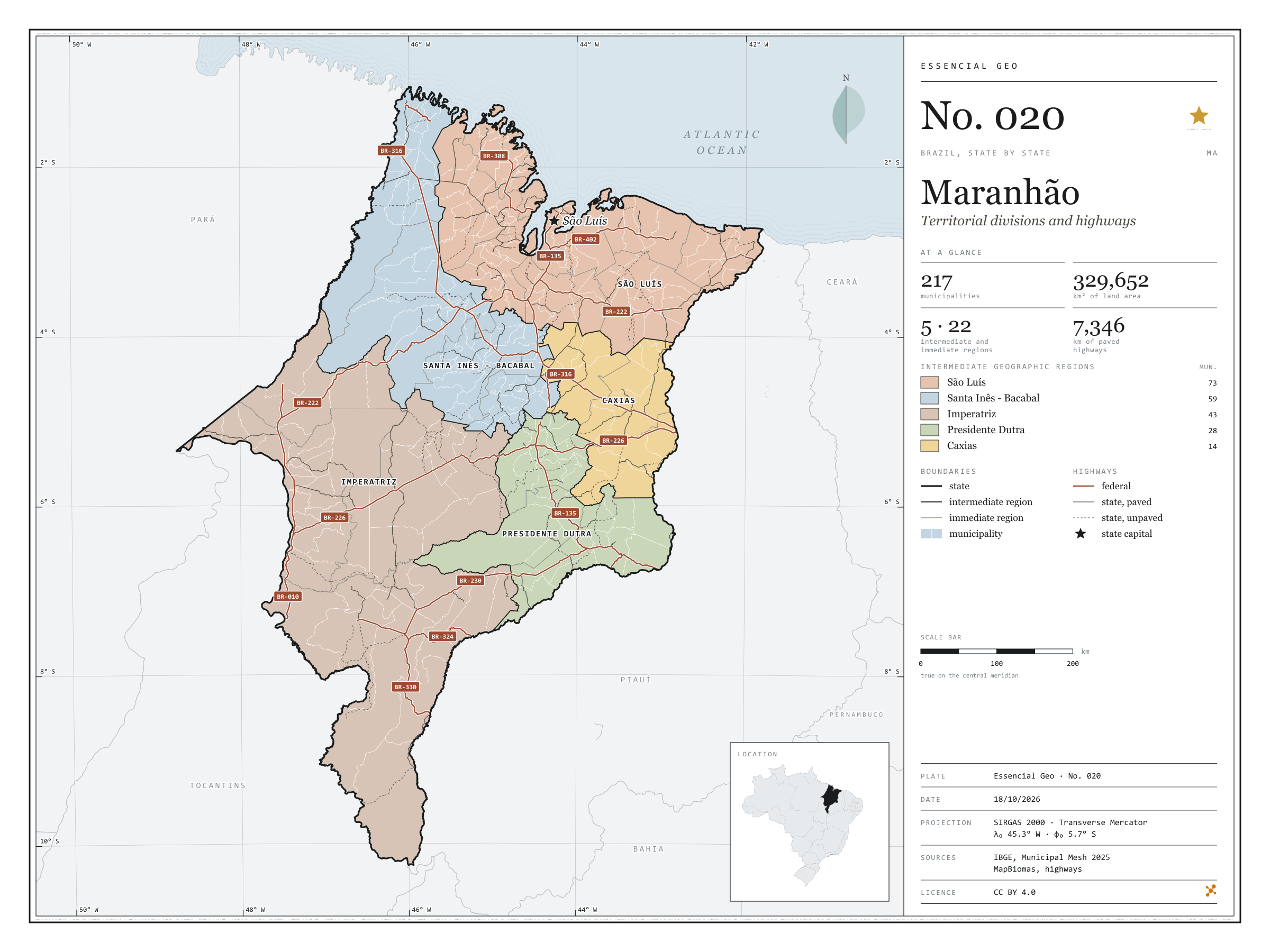
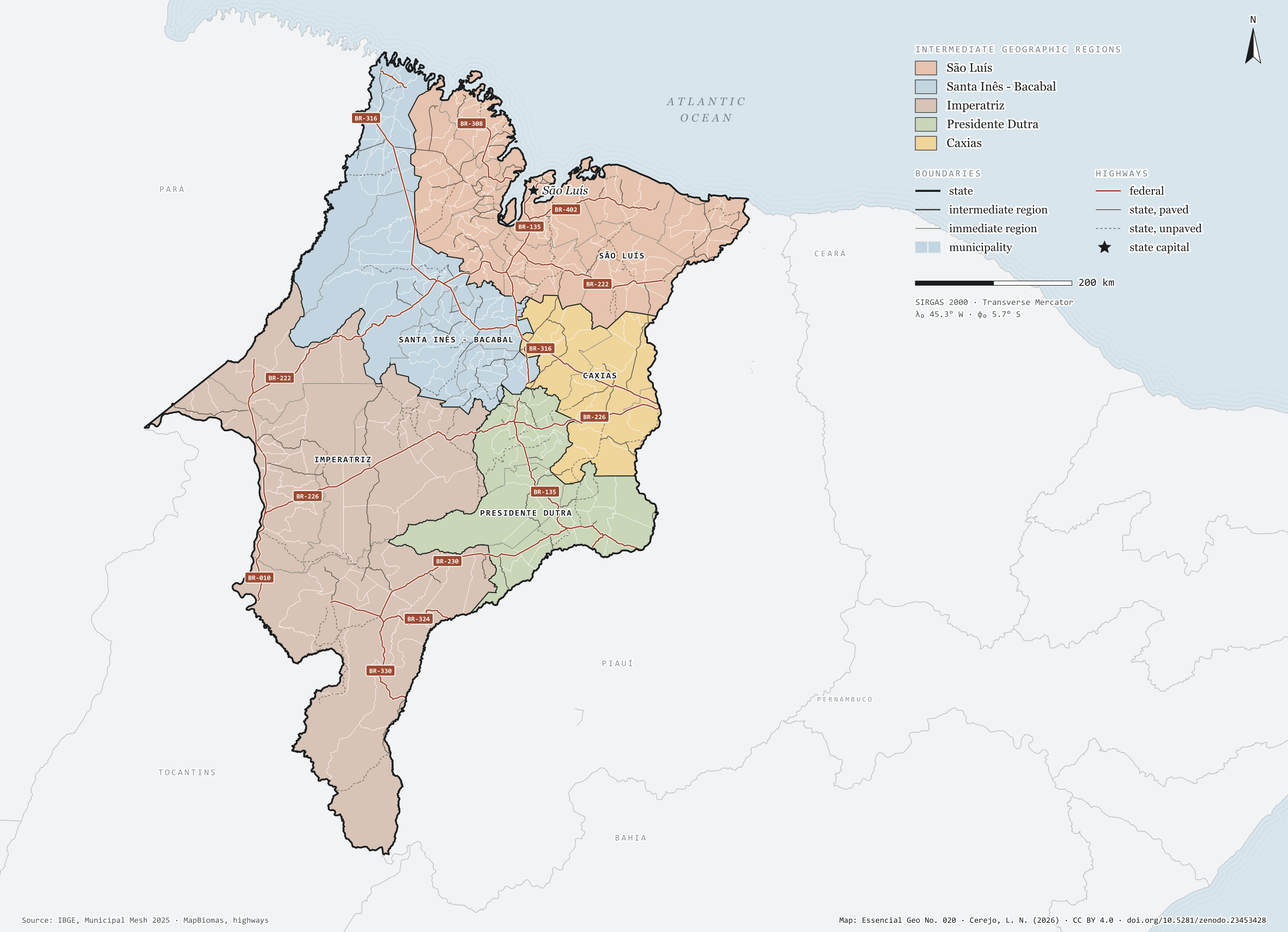
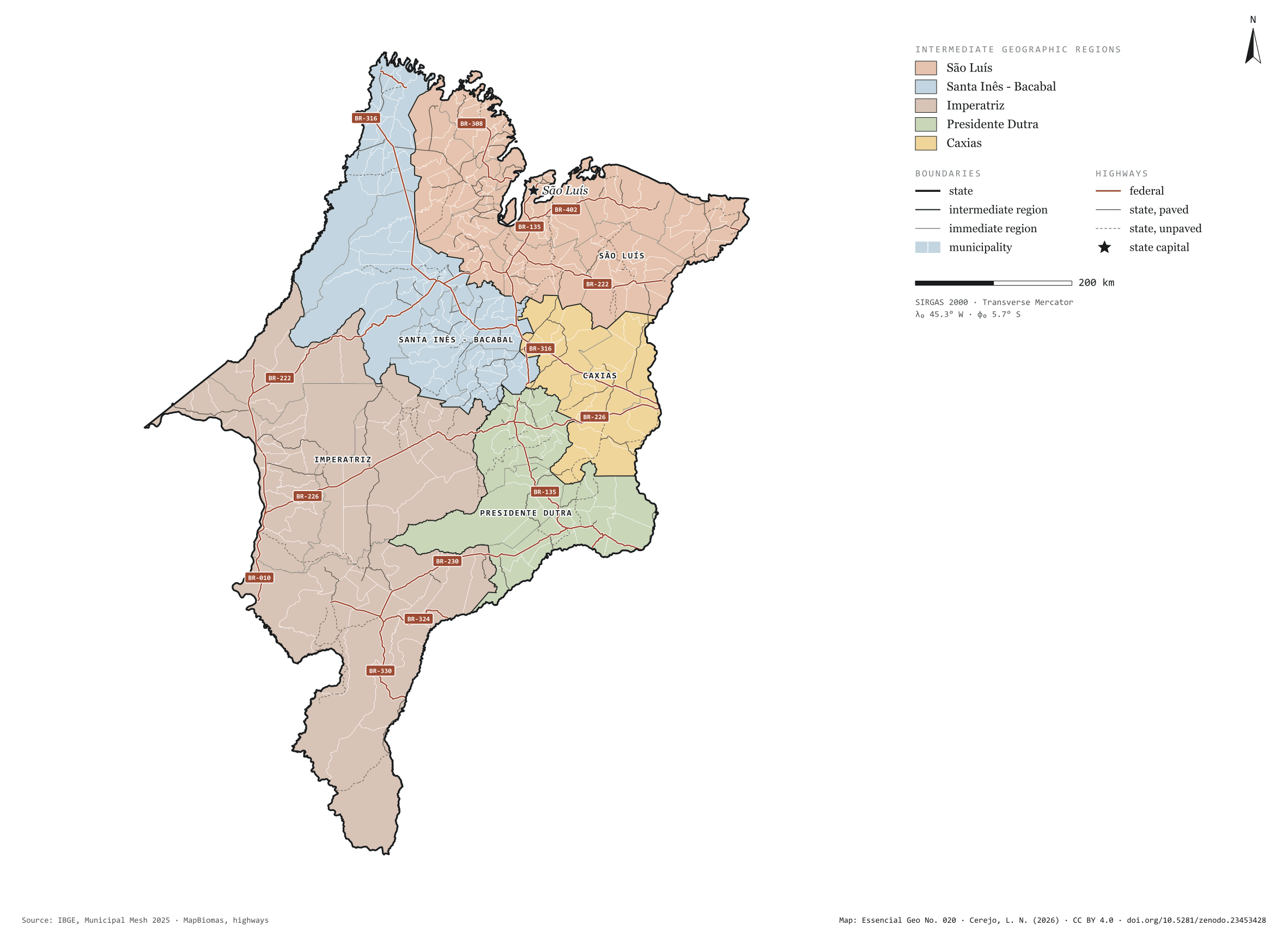
Fig. 020Maranhão state (MA)EPSG:4674Source: IBGE, MapBiomas, Natural Earth
Maranhão has 217 municipalities across 330,000 km², 3.9 per cent of Brazil. IBGE groups them into 22 immediate regions, drawn around the towns that supply jobs, trade and services to their surroundings, and into 5 intermediate regions that tie those networks together. São Luís is the intermediate region with the most municipalities (73); Caxias, the one with the fewest (14). The largest municipality is Balsas (12,602 km²); the smallest, Raposa (79 km²). Part of the series “Brazil, state by state”: a clean base, with official boundaries and the road network, to start a map without losing the first afternoon gathering files.
Technical record · downloads · citation
At a glance
Municipalities per intermediate region (municipalities)
São Luís73
Santa Inês - Bacabal59
Imperatriz43
Presidente Dutra28
Caxias14
Area
329,652km²
Largest municipality: Balsas (12,602 km²); smallest: Raposa (79 km²)
Paved highways
7,346km
3,745 km federal and 6,767 km state highways, paved or not
Layers
municipiospolygon217 municipalities, with IBGE code, regions, urban concentration and area (km²)
regioes_intermediariaspolygon5 intermediate geographic regions
regioes_imediataspolygon22 immediate geographic regions
limite_estadualpolygonBoundary of the federative unit
rodoviaslineFederal and state highways: route number, surface, physical status, carriageways
capitalpointIndicative point for the capital (not the exact seat)
The map without a frame, with legend, scale, reference system and credit written on it: ready for papers, lectures and slides. In two versions: with the basemap (neighbours and sea) or only the mapped area, on white.
CEREJO, Lucas Nakamura. Maranhão: divisão territorial e rodovias. Versão 1.0.0. [S. l.]: Zenodo, 2026. Conjunto de dados. DOI: 10.5281/zenodo.23453428. Disponível em: https://doi.org/10.5281/zenodo.23453428. Acesso em: 10 nov. 2026.
Cerejo, L. N. (2026). Maranhão: divisão territorial e rodovias [Maranhão: Territorial divisions and highways] (Version 1.0.0) [Data set]. Zenodo. https://doi.org/10.5281/zenodo.23453428
@dataset{cerejo2026_estado_maranhao,
  author    = {Cerejo, Lucas Nakamura},
  title     = {Maranhão: Divisão territorial e rodovias},
  year      = {2026},
  publisher = {Zenodo},
  version   = {1.0.0},
  doi       = {10.5281/zenodo.23453428},
  url       = {https://doi.org/10.5281/zenodo.23453428},
  language  = {portuguese},
  note      = {English title: Maranhão: Territorial divisions and highways. Licence CC BY 4.0}
}
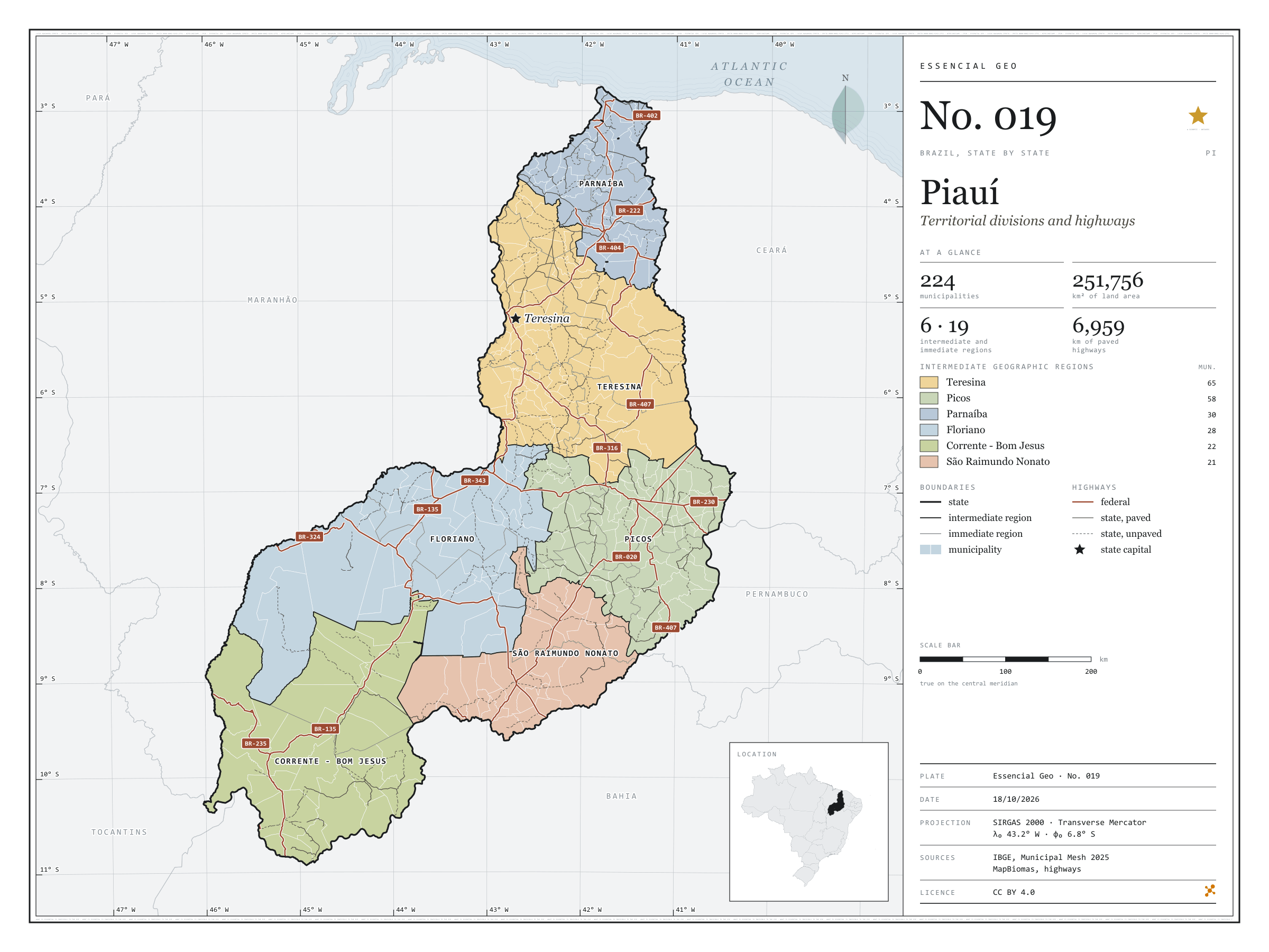
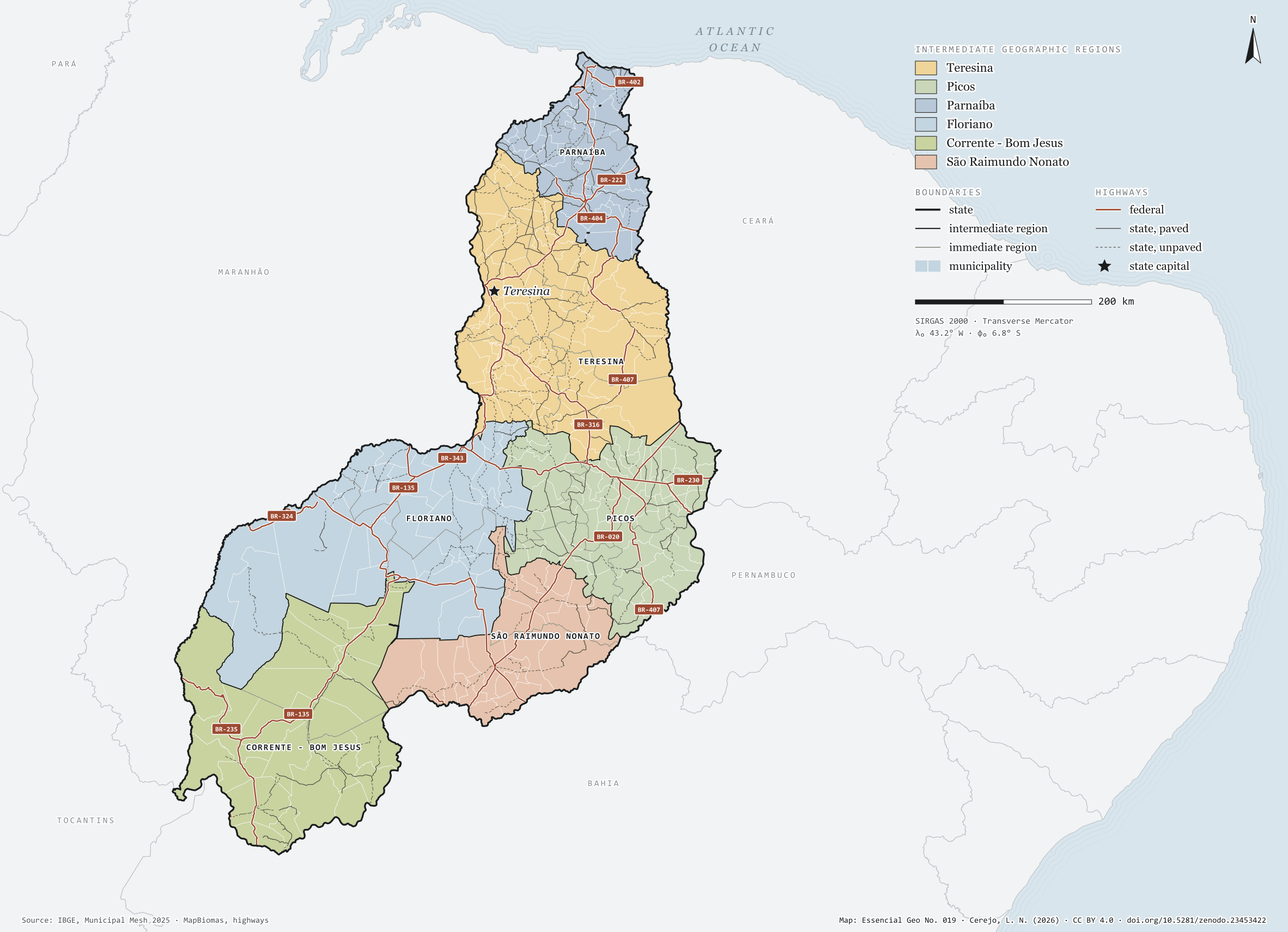
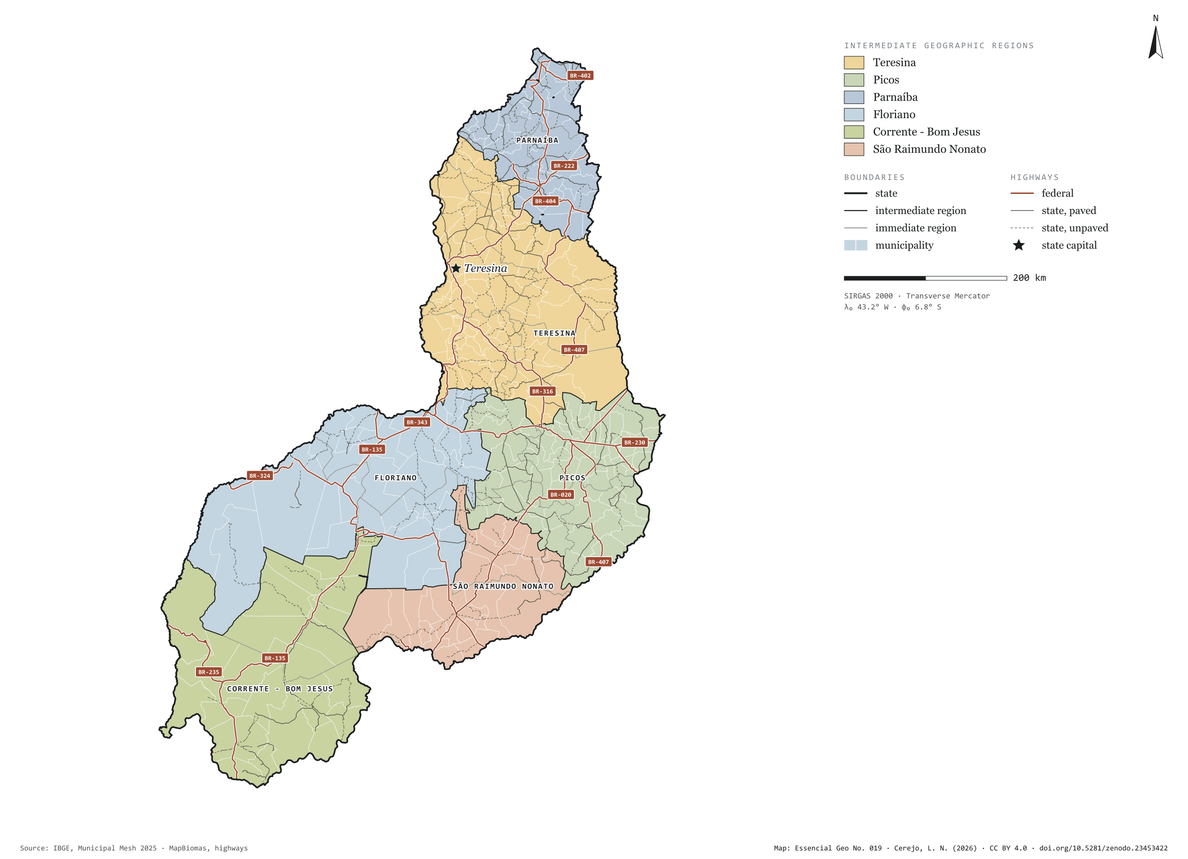
Fig. 019Piauí state (PI)EPSG:4674Source: IBGE, MapBiomas, Natural Earth
Piauí has 224 municipalities across 252,000 km², 3.0 per cent of Brazil. IBGE groups them into 19 immediate regions, drawn around the towns that supply jobs, trade and services to their surroundings, and into 6 intermediate regions that tie those networks together. Teresina is the intermediate region with the most municipalities (65); São Raimundo Nonato, the one with the fewest (21). The largest municipality is Uruçuí (8,413 km²); the smallest, Santo Antônio dos Milagres (34 km²). Part of the series “Brazil, state by state”: a clean base, with official boundaries and the road network, to start a map without losing the first afternoon gathering files.
Technical record · downloads · citation
At a glance
Municipalities per intermediate region (municipalities)
Teresina65
Picos58
Parnaíba30
Floriano28
Corrente - Bom Jesus22
São Raimundo Nonato21
Area
251,756km²
Largest municipality: Uruçuí (8,413 km²); smallest: Santo Antônio dos Milagres (34 km²)
Paved highways
6,959km
3,564 km federal and 8,626 km state highways, paved or not
Layers
municipiospolygon224 municipalities, with IBGE code, regions, urban concentration and area (km²)
regioes_intermediariaspolygon6 intermediate geographic regions
regioes_imediataspolygon19 immediate geographic regions
limite_estadualpolygonBoundary of the federative unit
rodoviaslineFederal and state highways: route number, surface, physical status, carriageways
capitalpointIndicative point for the capital (not the exact seat)
The map without a frame, with legend, scale, reference system and credit written on it: ready for papers, lectures and slides. In two versions: with the basemap (neighbours and sea) or only the mapped area, on white.
CEREJO, Lucas Nakamura. Piauí: divisão territorial e rodovias. Versão 1.0.0. [S. l.]: Zenodo, 2026. Conjunto de dados. DOI: 10.5281/zenodo.23453422. Disponível em: https://doi.org/10.5281/zenodo.23453422. Acesso em: 10 nov. 2026.
Cerejo, L. N. (2026). Piauí: divisão territorial e rodovias [Piauí: Territorial divisions and highways] (Version 1.0.0) [Data set]. Zenodo. https://doi.org/10.5281/zenodo.23453422
@dataset{cerejo2026_estado_piaui,
  author    = {Cerejo, Lucas Nakamura},
  title     = {Piauí: Divisão territorial e rodovias},
  year      = {2026},
  publisher = {Zenodo},
  version   = {1.0.0},
  doi       = {10.5281/zenodo.23453422},
  url       = {https://doi.org/10.5281/zenodo.23453422},
  language  = {portuguese},
  note      = {English title: Piauí: Territorial divisions and highways. Licence CC BY 4.0}
}
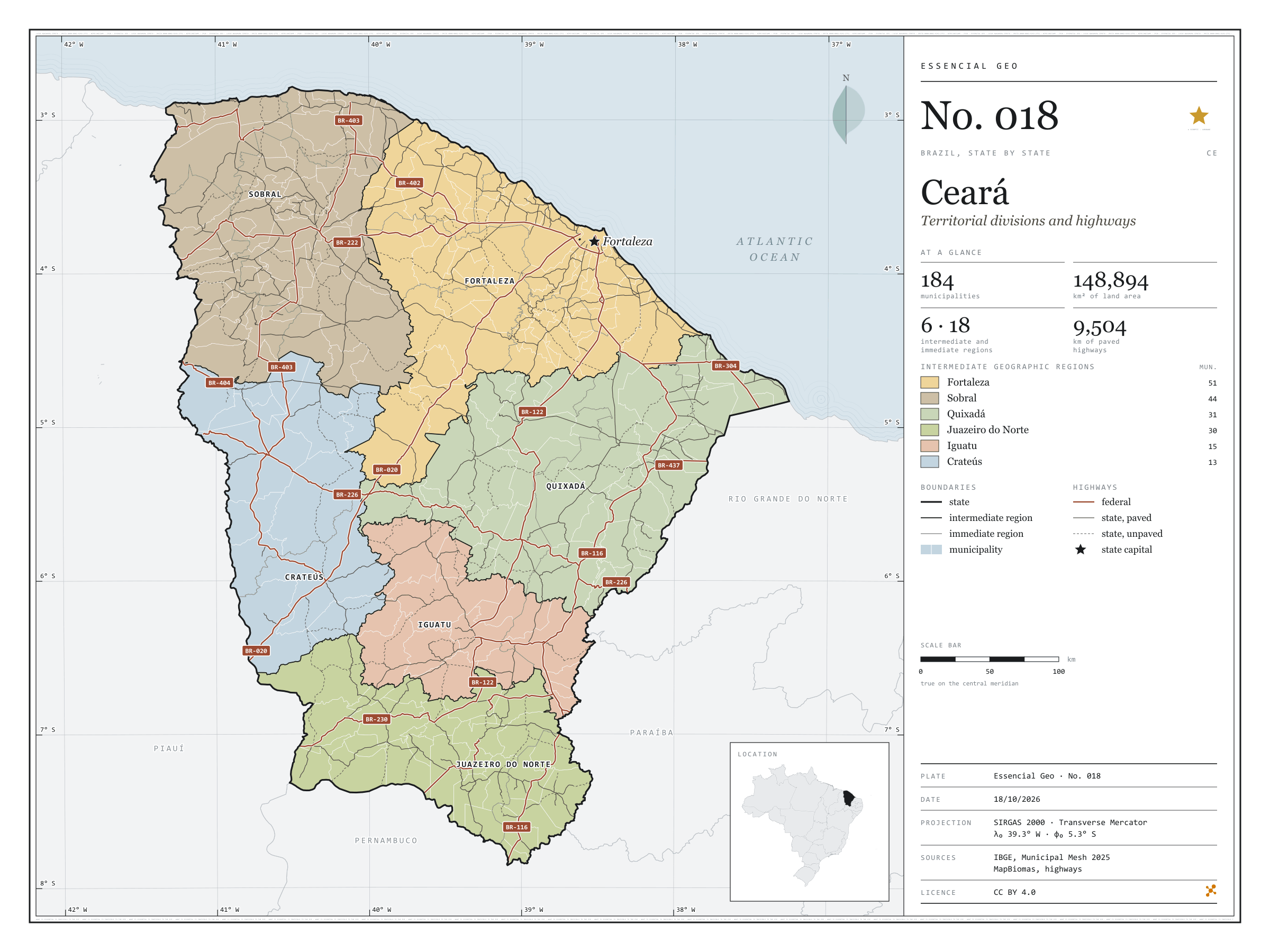
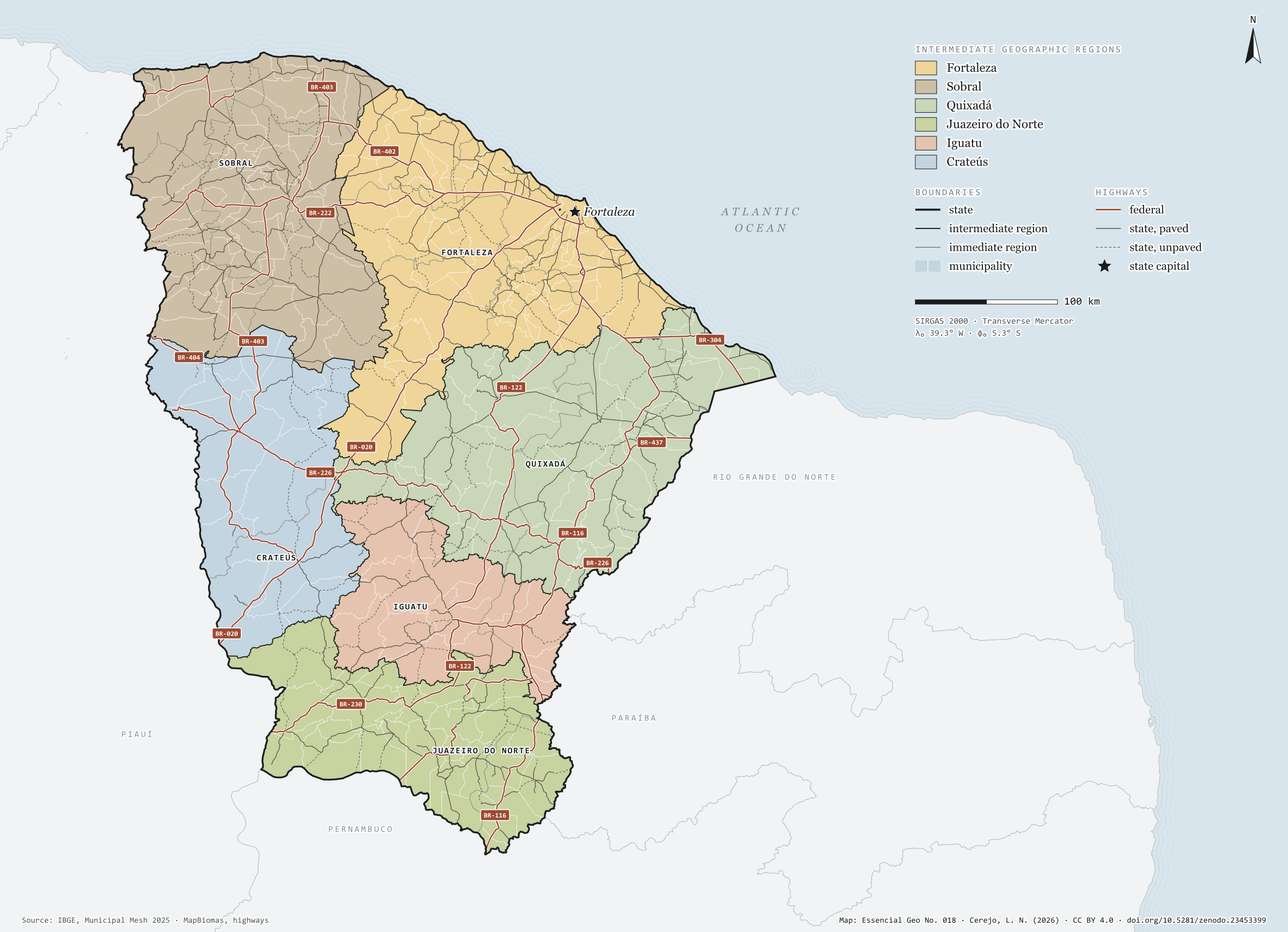
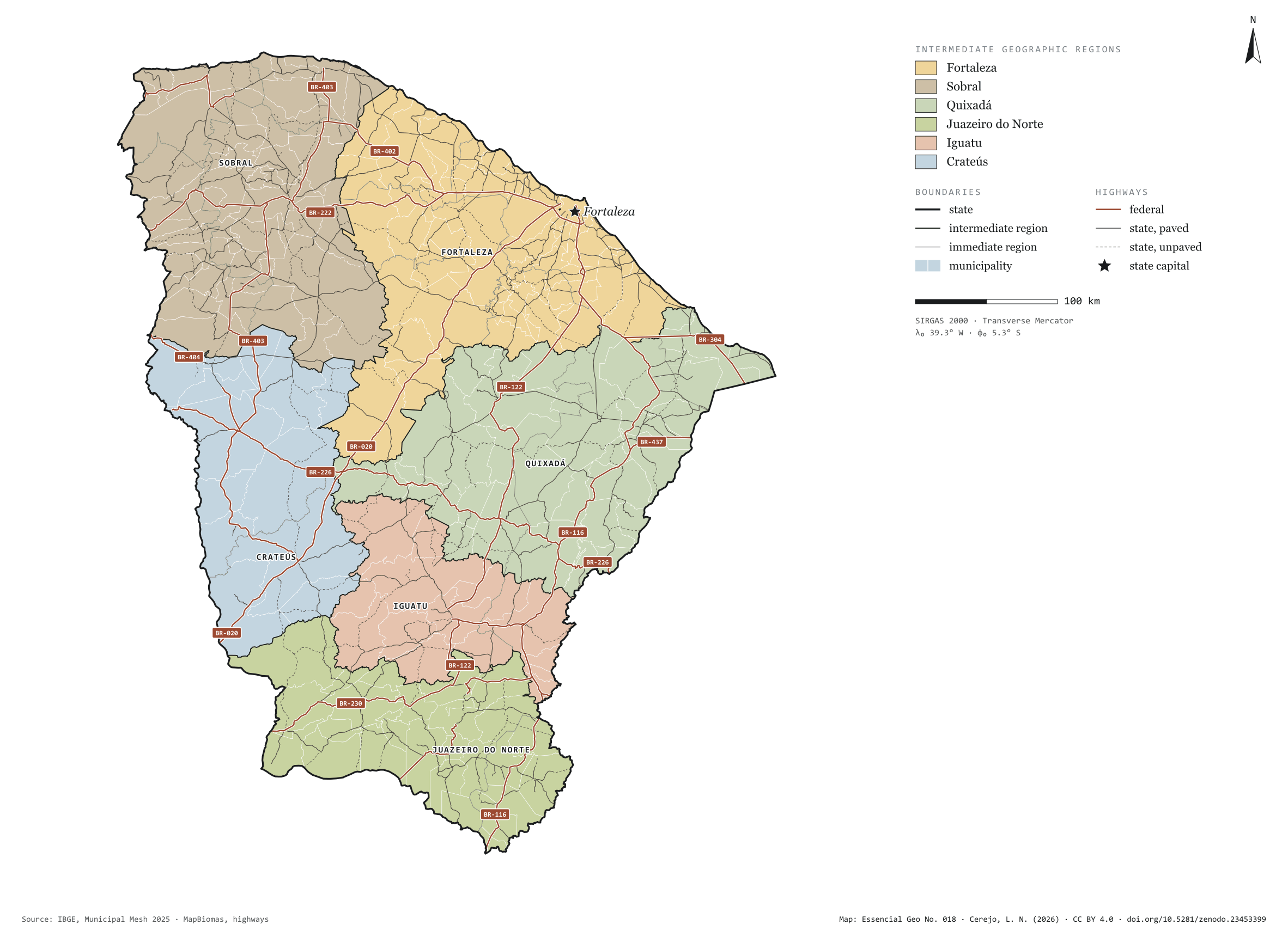
Fig. 018Ceará state (CE)EPSG:4674Source: IBGE, MapBiomas, Natural Earth
Ceará has 184 municipalities across 149,000 km², 1.7 per cent of Brazil. IBGE groups them into 18 immediate regions, drawn around the towns that supply jobs, trade and services to their surroundings, and into 6 intermediate regions that tie those networks together. Fortaleza is the intermediate region with the most municipalities (51); Crateús, the one with the fewest (13). The largest municipality is Santa Quitéria (4,262 km²); the smallest, Altaneira (73 km²). Part of the series “Brazil, state by state”: a clean base, with official boundaries and the road network, to start a map without losing the first afternoon gathering files.
Technical record · downloads · citation
At a glance
Municipalities per intermediate region (municipalities)
Fortaleza51
Sobral44
Quixadá31
Juazeiro do Norte30
Iguatu15
Crateús13
Area
148,894km²
Largest municipality: Santa Quitéria (4,262 km²); smallest: Altaneira (73 km²)
Paved highways
9,504km
3,287 km federal and 9,311 km state highways, paved or not
Layers
municipiospolygon184 municipalities, with IBGE code, regions, urban concentration and area (km²)
regioes_intermediariaspolygon6 intermediate geographic regions
regioes_imediataspolygon18 immediate geographic regions
limite_estadualpolygonBoundary of the federative unit
rodoviaslineFederal and state highways: route number, surface, physical status, carriageways
capitalpointIndicative point for the capital (not the exact seat)
The map without a frame, with legend, scale, reference system and credit written on it: ready for papers, lectures and slides. In two versions: with the basemap (neighbours and sea) or only the mapped area, on white.
CEREJO, Lucas Nakamura. Ceará: divisão territorial e rodovias. Versão 1.0.0. [S. l.]: Zenodo, 2026. Conjunto de dados. DOI: 10.5281/zenodo.23453399. Disponível em: https://doi.org/10.5281/zenodo.23453399. Acesso em: 10 nov. 2026.
Cerejo, L. N. (2026). Ceará: divisão territorial e rodovias [Ceará: Territorial divisions and highways] (Version 1.0.0) [Data set]. Zenodo. https://doi.org/10.5281/zenodo.23453399
@dataset{cerejo2026_estado_ceara,
  author    = {Cerejo, Lucas Nakamura},
  title     = {Ceará: Divisão territorial e rodovias},
  year      = {2026},
  publisher = {Zenodo},
  version   = {1.0.0},
  doi       = {10.5281/zenodo.23453399},
  url       = {https://doi.org/10.5281/zenodo.23453399},
  language  = {portuguese},
  note      = {English title: Ceará: Territorial divisions and highways. Licence CC BY 4.0}
}
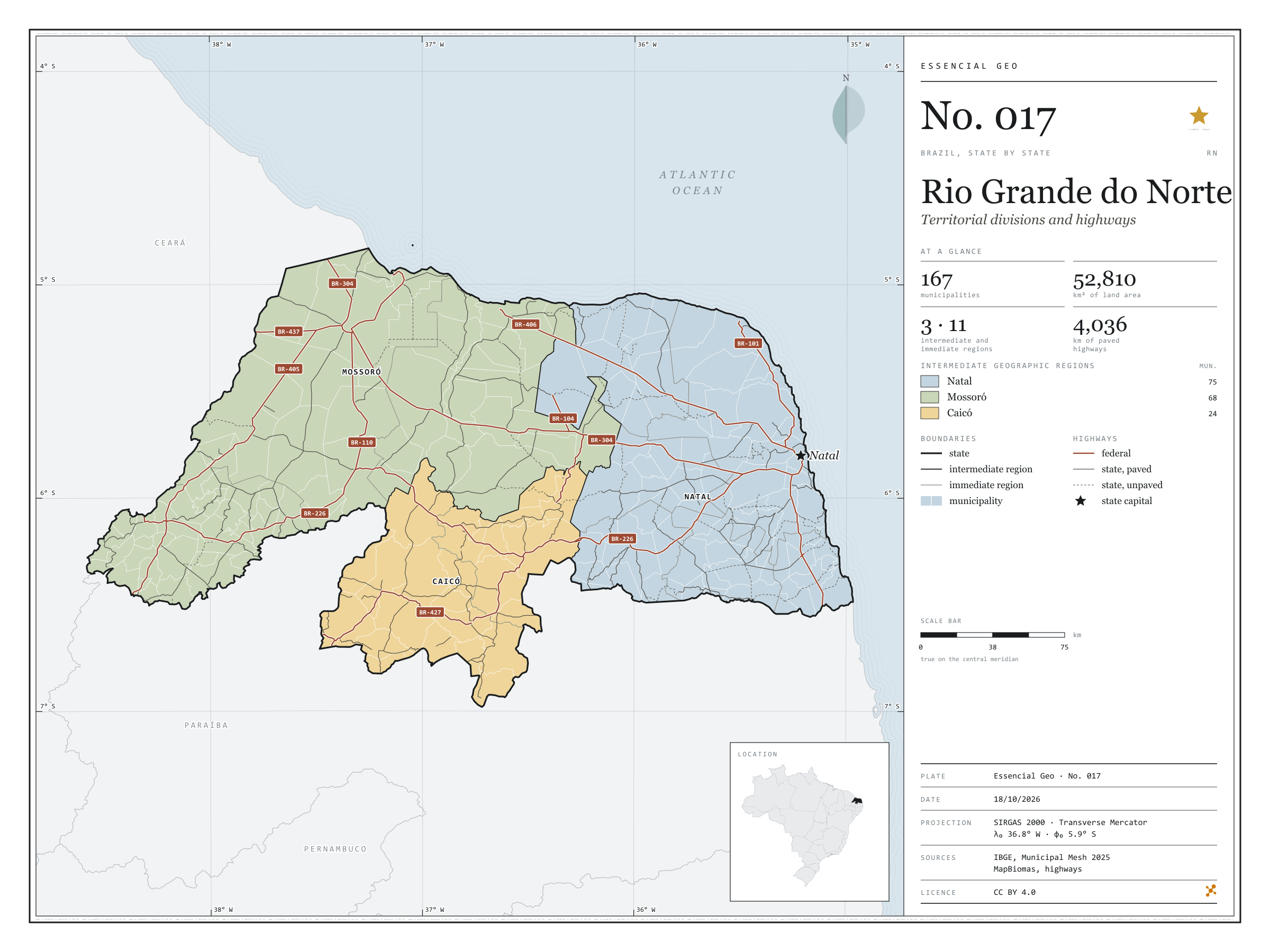
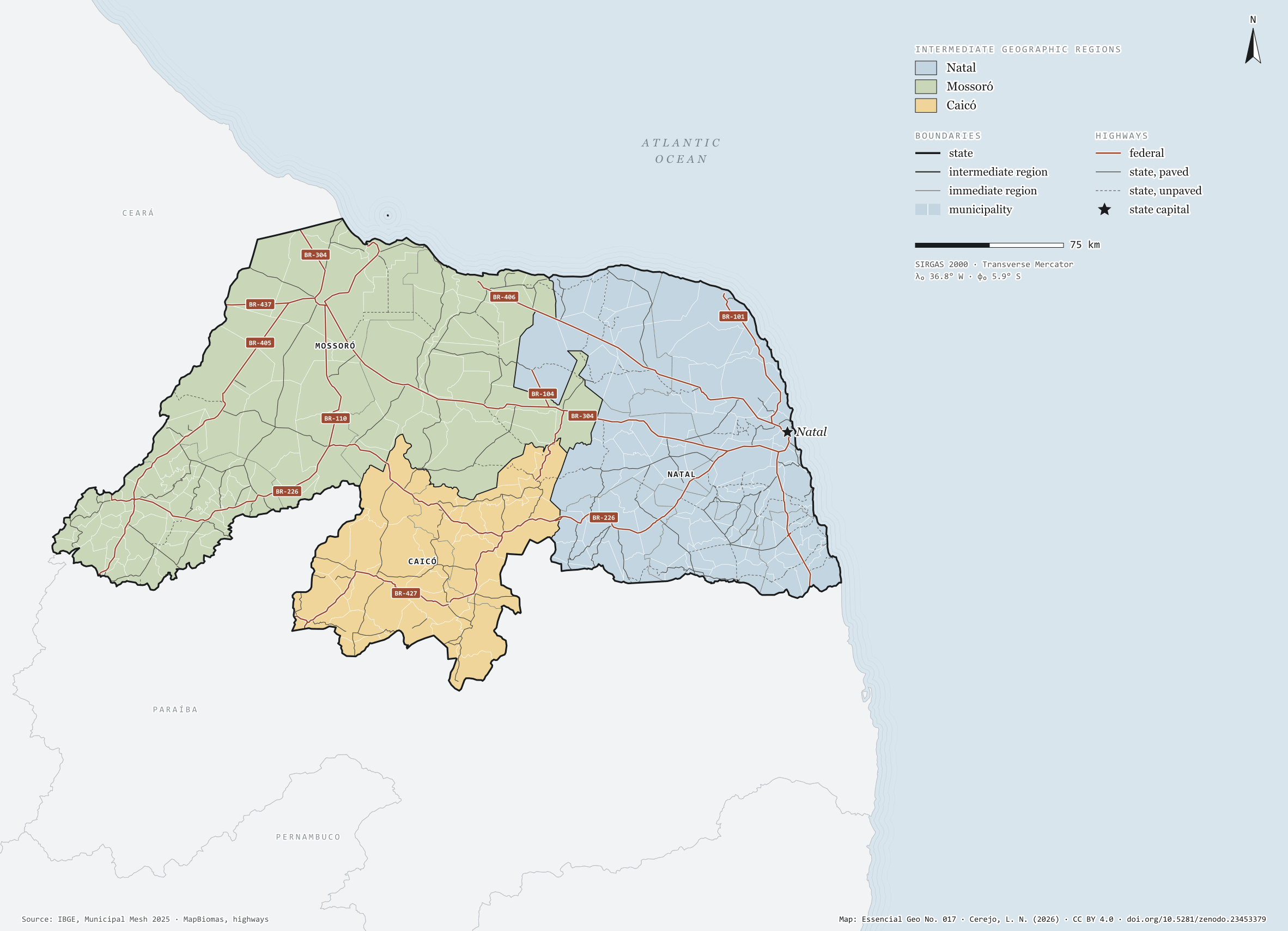
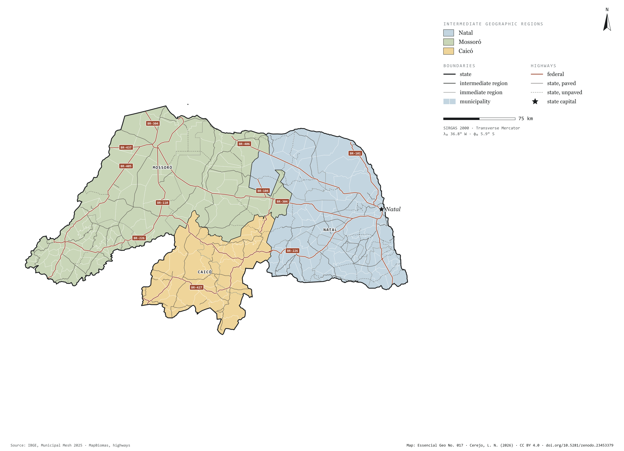
Fig. 017Rio Grande do Norte state (RN)EPSG:4674Source: IBGE, MapBiomas, Natural Earth
Rio Grande do Norte has 167 municipalities across 53,000 km², 0.6 per cent of Brazil. IBGE groups them into 11 immediate regions, drawn around the towns that supply jobs, trade and services to their surroundings, and into 3 intermediate regions that tie those networks together. Natal is the intermediate region with the most municipalities (75); Caicó, the one with the fewest (24). The largest municipality is Mossoró (2,099 km²); the smallest, Senador Georgino Avelino (26 km²). Part of the series “Brazil, state by state”: a clean base, with official boundaries and the road network, to start a map without losing the first afternoon gathering files.
Technical record · downloads · citation
At a glance
Municipalities per intermediate region (municipalities)
The map without a frame, with legend, scale, reference system and credit written on it: ready for papers, lectures and slides. In two versions: with the basemap (neighbours and sea) or only the mapped area, on white.
CEREJO, Lucas Nakamura. Rio Grande do Norte: divisão territorial e rodovias. Versão 1.0.0. [S. l.]: Zenodo, 2026. Conjunto de dados. DOI: 10.5281/zenodo.23453379. Disponível em: https://doi.org/10.5281/zenodo.23453379. Acesso em: 10 nov. 2026.
Cerejo, L. N. (2026). Rio Grande do Norte: divisão territorial e rodovias [Rio Grande do Norte: Territorial divisions and highways] (Version 1.0.0) [Data set]. Zenodo. https://doi.org/10.5281/zenodo.23453379
@dataset{cerejo2026_estado_rio_grande_do_norte,
  author    = {Cerejo, Lucas Nakamura},
  title     = {Rio Grande do Norte: Divisão territorial e rodovias},
  year      = {2026},
  publisher = {Zenodo},
  version   = {1.0.0},
  doi       = {10.5281/zenodo.23453379},
  url       = {https://doi.org/10.5281/zenodo.23453379},
  language  = {portuguese},
  note      = {English title: Rio Grande do Norte: Territorial divisions and highways. Licence CC BY 4.0}
}
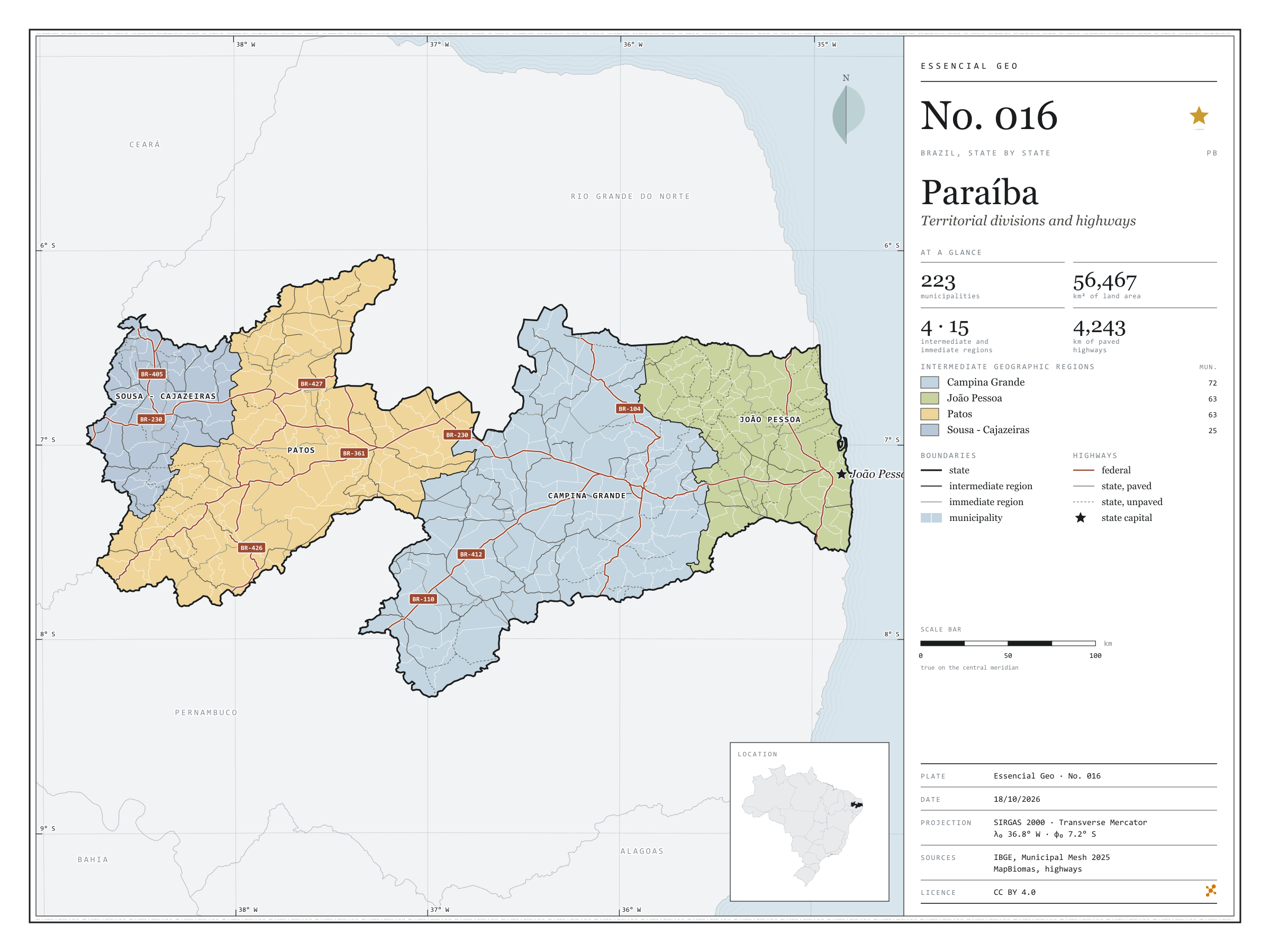
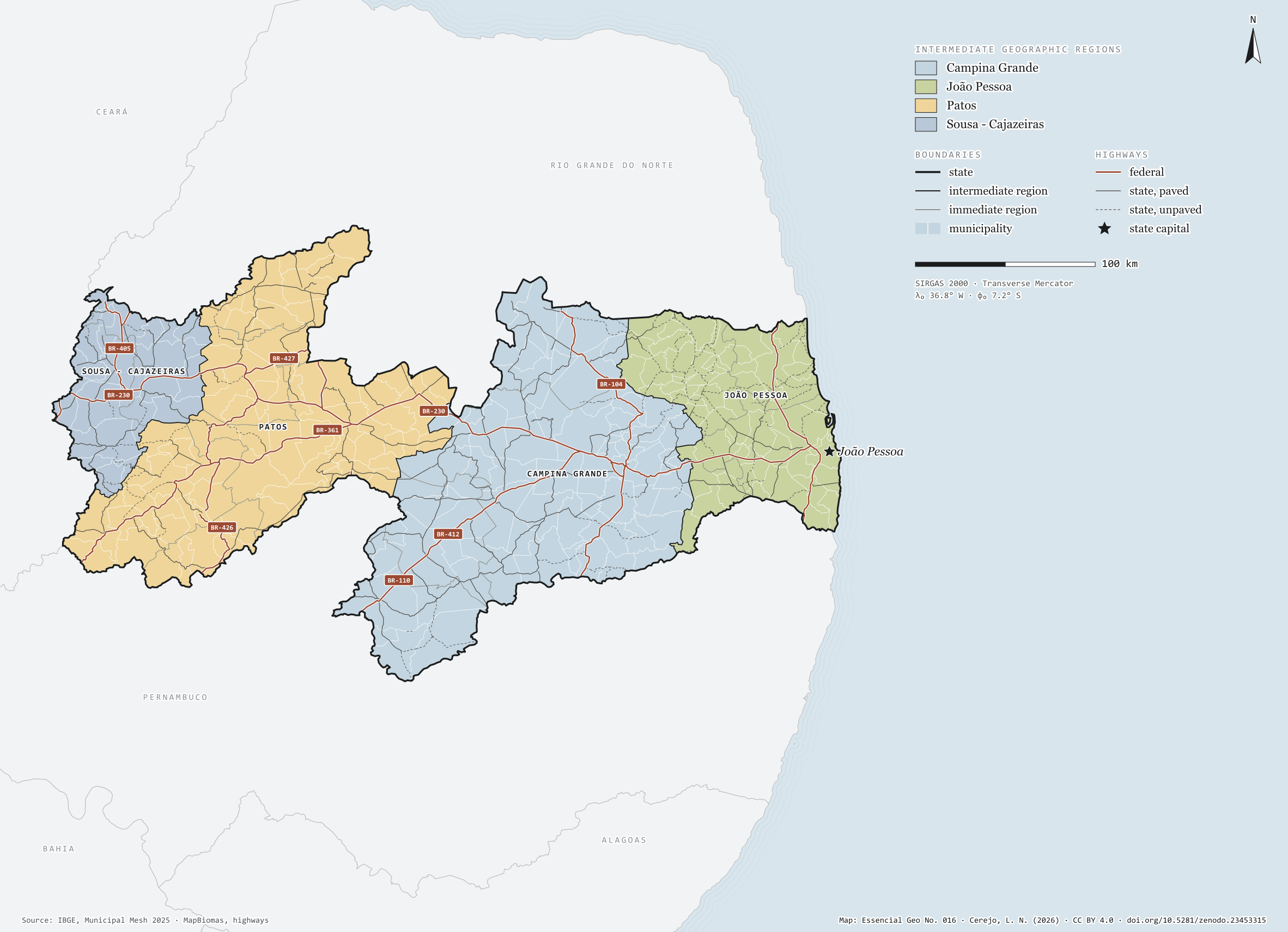
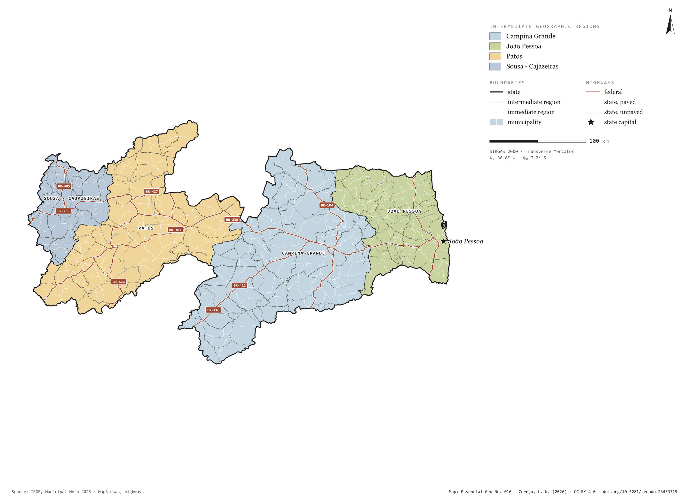
Fig. 016Paraíba state (PB)EPSG:4674Source: IBGE, MapBiomas, Natural Earth
Paraíba has 223 municipalities across 56,000 km², 0.7 per cent of Brazil. IBGE groups them into 15 immediate regions, drawn around the towns that supply jobs, trade and services to their surroundings, and into 4 intermediate regions that tie those networks together. Campina Grande is the intermediate region with the most municipalities (72); Sousa - Cajazeiras, the one with the fewest (25). The largest municipality is Monteiro (993 km²); the smallest, Borborema (26 km²). Part of the series “Brazil, state by state”: a clean base, with official boundaries and the road network, to start a map without losing the first afternoon gathering files.
Technical record · downloads · citation
At a glance
Municipalities per intermediate region (municipalities)
Campina Grande72
João Pessoa63
Patos63
Sousa - Cajazeiras25
Area
56,467km²
Largest municipality: Monteiro (993 km²); smallest: Borborema (26 km²)
Paved highways
4,243km
1,469 km federal and 4,178 km state highways, paved or not
Layers
municipiospolygon223 municipalities, with IBGE code, regions, urban concentration and area (km²)
regioes_intermediariaspolygon4 intermediate geographic regions
regioes_imediataspolygon15 immediate geographic regions
limite_estadualpolygonBoundary of the federative unit
rodoviaslineFederal and state highways: route number, surface, physical status, carriageways
capitalpointIndicative point for the capital (not the exact seat)
The map without a frame, with legend, scale, reference system and credit written on it: ready for papers, lectures and slides. In two versions: with the basemap (neighbours and sea) or only the mapped area, on white.
CEREJO, Lucas Nakamura. Paraíba: divisão territorial e rodovias. Versão 1.0.0. [S. l.]: Zenodo, 2026. Conjunto de dados. DOI: 10.5281/zenodo.23453315. Disponível em: https://doi.org/10.5281/zenodo.23453315. Acesso em: 10 nov. 2026.
Cerejo, L. N. (2026). Paraíba: divisão territorial e rodovias [Paraíba: Territorial divisions and highways] (Version 1.0.0) [Data set]. Zenodo. https://doi.org/10.5281/zenodo.23453315
@dataset{cerejo2026_estado_paraiba,
  author    = {Cerejo, Lucas Nakamura},
  title     = {Paraíba: Divisão territorial e rodovias},
  year      = {2026},
  publisher = {Zenodo},
  version   = {1.0.0},
  doi       = {10.5281/zenodo.23453315},
  url       = {https://doi.org/10.5281/zenodo.23453315},
  language  = {portuguese},
  note      = {English title: Paraíba: Territorial divisions and highways. Licence CC BY 4.0}
}
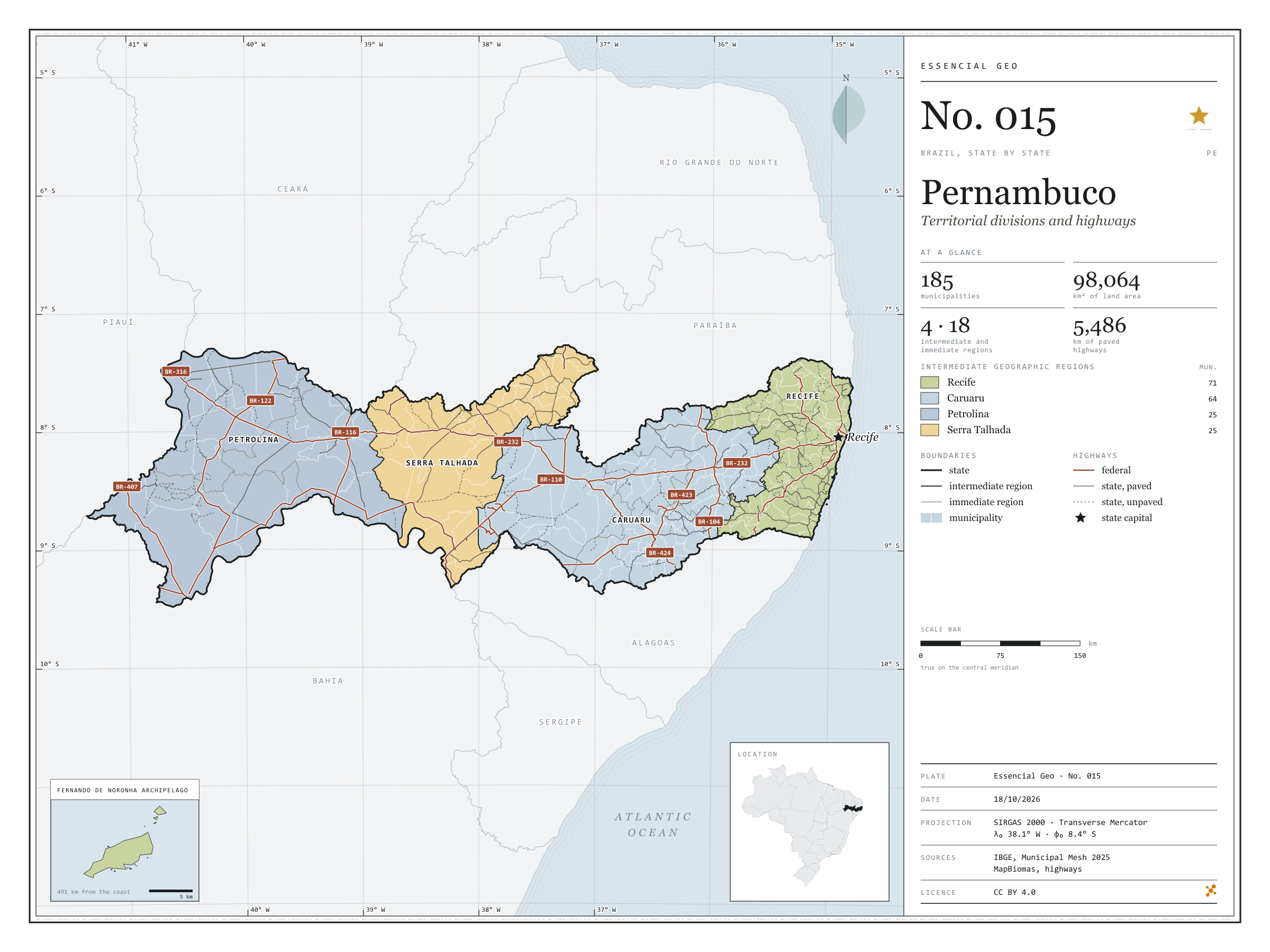
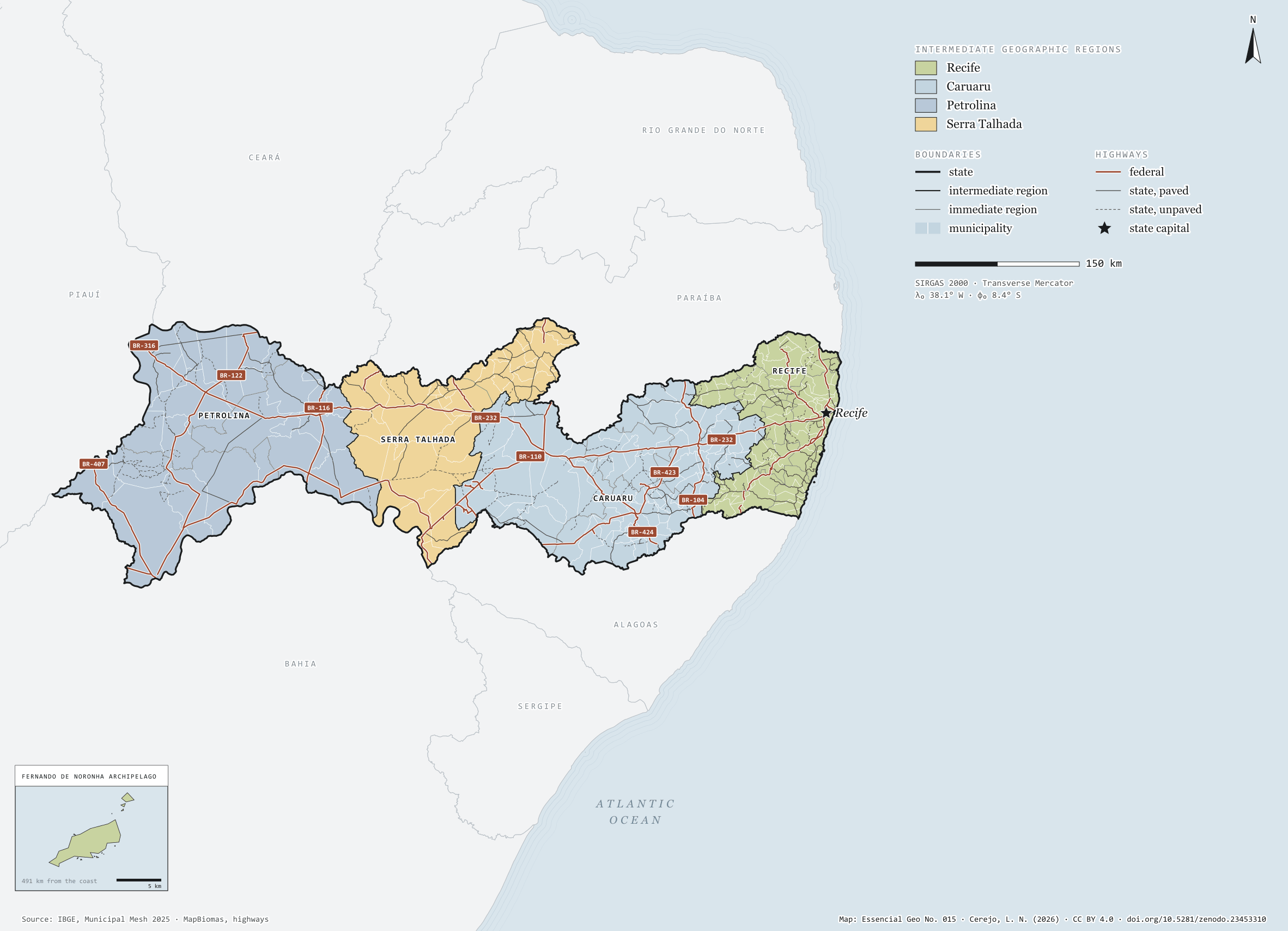
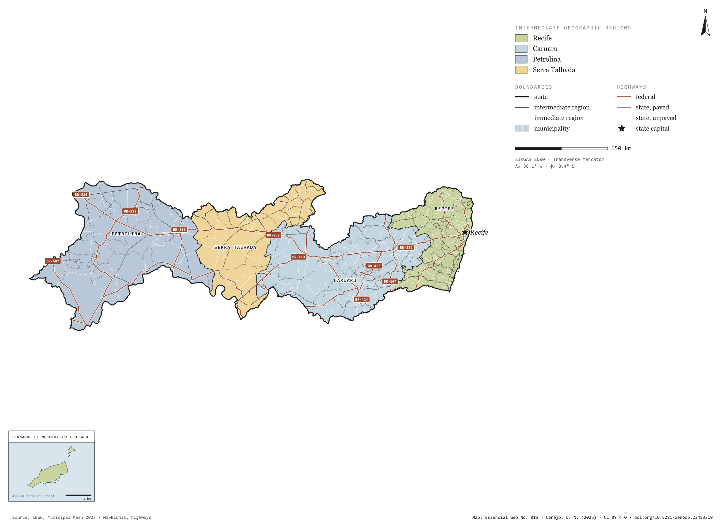
Fig. 015Pernambuco state (PE)EPSG:4674Source: IBGE, MapBiomas, Natural Earth
Pernambuco has 185 municipalities across 98,000 km², 1.2 per cent of Brazil. IBGE groups them into 18 immediate regions, drawn around the towns that supply jobs, trade and services to their surroundings, and into 4 intermediate regions that tie those networks together. Recife is the intermediate region with the most municipalities (71); Serra Talhada, the one with the fewest (25). The largest municipality is Petrolina (4,559 km²); the smallest, Fernando de Noronha (19 km²). Part of the series “Brazil, state by state”: a clean base, with official boundaries and the road network, to start a map without losing the first afternoon gathering files.
Technical record · downloads · citation
At a glance
Municipalities per intermediate region (municipalities)
Recife71
Caruaru64
Petrolina25
Serra Talhada25
Area
98,064km²
Largest municipality: Petrolina (4,559 km²); smallest: Fernando de Noronha (19 km²)
Paved highways
5,486km
2,701 km federal and 4,823 km state highways, paved or not
Layers
municipiospolygon185 municipalities, with IBGE code, regions, urban concentration and area (km²)
regioes_intermediariaspolygon4 intermediate geographic regions
regioes_imediataspolygon18 immediate geographic regions
limite_estadualpolygonBoundary of the federative unit
rodoviaslineFederal and state highways: route number, surface, physical status, carriageways
capitalpointIndicative point for the capital (not the exact seat)
The map without a frame, with legend, scale, reference system and credit written on it: ready for papers, lectures and slides. In two versions: with the basemap (neighbours and sea) or only the mapped area, on white.
CEREJO, Lucas Nakamura. Pernambuco: divisão territorial e rodovias. Versão 1.0.0. [S. l.]: Zenodo, 2026. Conjunto de dados. DOI: 10.5281/zenodo.23453310. Disponível em: https://doi.org/10.5281/zenodo.23453310. Acesso em: 10 nov. 2026.
Cerejo, L. N. (2026). Pernambuco: divisão territorial e rodovias [Pernambuco: Territorial divisions and highways] (Version 1.0.0) [Data set]. Zenodo. https://doi.org/10.5281/zenodo.23453310
@dataset{cerejo2026_estado_pernambuco,
  author    = {Cerejo, Lucas Nakamura},
  title     = {Pernambuco: Divisão territorial e rodovias},
  year      = {2026},
  publisher = {Zenodo},
  version   = {1.0.0},
  doi       = {10.5281/zenodo.23453310},
  url       = {https://doi.org/10.5281/zenodo.23453310},
  language  = {portuguese},
  note      = {English title: Pernambuco: Territorial divisions and highways. Licence CC BY 4.0}
}
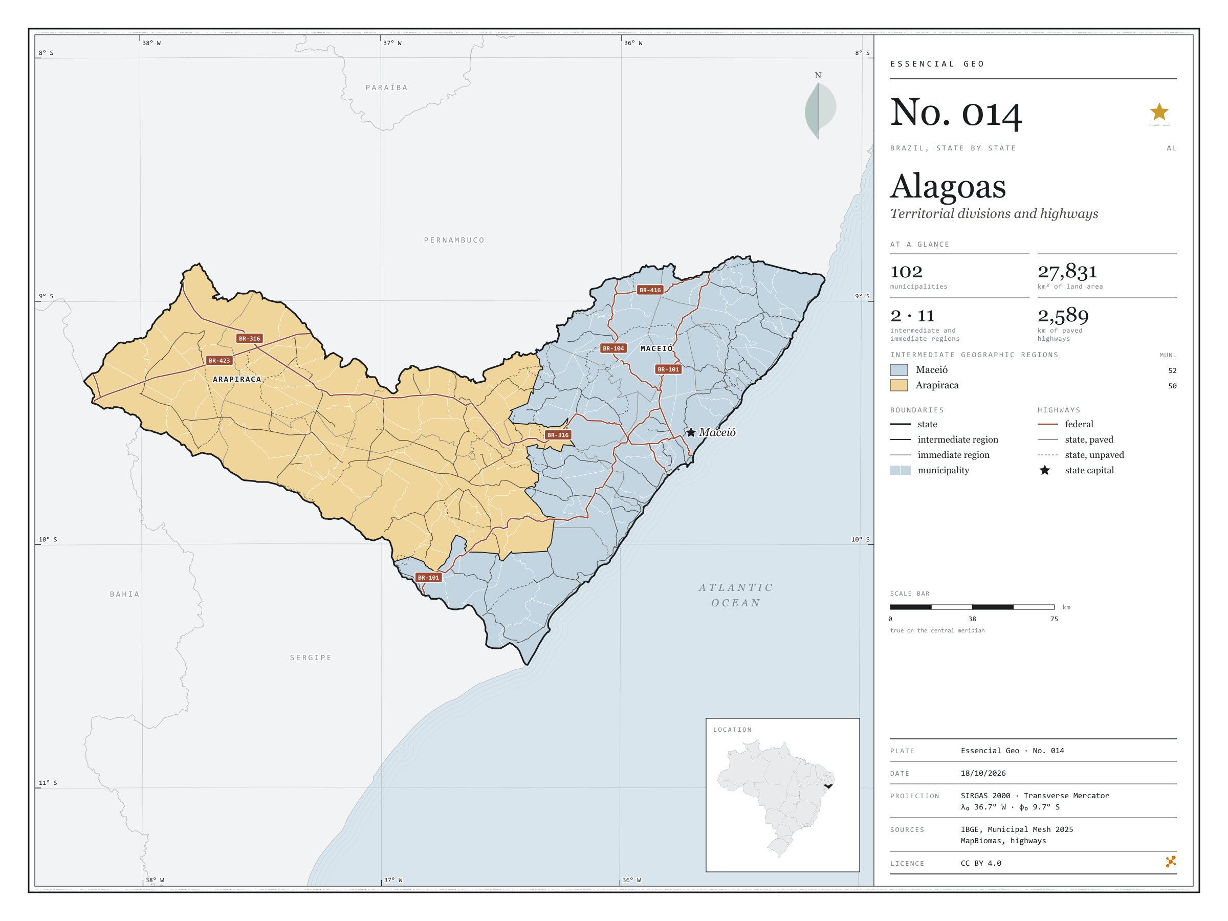
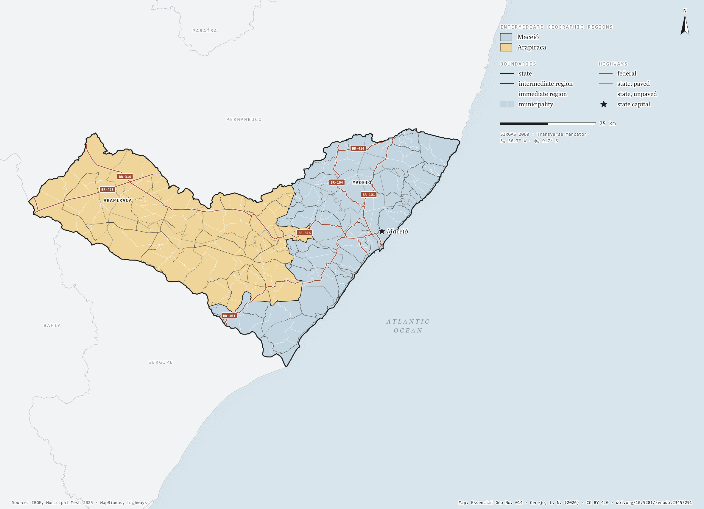
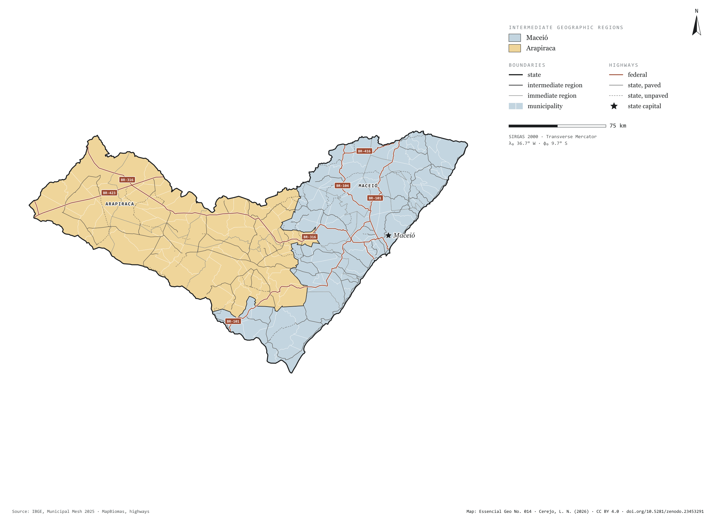
Fig. 014Alagoas state (AL)EPSG:4674Source: IBGE, MapBiomas, Natural Earth
Alagoas has 102 municipalities across 28,000 km², 0.3 per cent of Brazil. IBGE groups them into 11 immediate regions, drawn around the towns that supply jobs, trade and services to their surroundings, and into 2 intermediate regions that tie those networks together. Maceió is the intermediate region with the most municipalities (52); Arapiraca, the one with the fewest (50). The largest municipality is Mata Grande (910 km²); the smallest, Santa Luzia do Norte (29 km²). Part of the series “Brazil, state by state”: a clean base, with official boundaries and the road network, to start a map without losing the first afternoon gathering files.
Technical record · downloads · citation
At a glance
Municipalities per intermediate region (municipalities)
Maceió52
Arapiraca50
Area
27,831km²
Largest municipality: Mata Grande (910 km²); smallest: Santa Luzia do Norte (29 km²)
Paved highways
2,589km
805 km federal and 2,441 km state highways, paved or not
Layers
municipiospolygon102 municipalities, with IBGE code, regions, urban concentration and area (km²)
regioes_intermediariaspolygon2 intermediate geographic regions
regioes_imediataspolygon11 immediate geographic regions
limite_estadualpolygonBoundary of the federative unit
rodoviaslineFederal and state highways: route number, surface, physical status, carriageways
capitalpointIndicative point for the capital (not the exact seat)
The map without a frame, with legend, scale, reference system and credit written on it: ready for papers, lectures and slides. In two versions: with the basemap (neighbours and sea) or only the mapped area, on white.
CEREJO, Lucas Nakamura. Alagoas: divisão territorial e rodovias. Versão 1.0.0. [S. l.]: Zenodo, 2026. Conjunto de dados. DOI: 10.5281/zenodo.23453291. Disponível em: https://doi.org/10.5281/zenodo.23453291. Acesso em: 10 nov. 2026.
Cerejo, L. N. (2026). Alagoas: divisão territorial e rodovias [Alagoas: Territorial divisions and highways] (Version 1.0.0) [Data set]. Zenodo. https://doi.org/10.5281/zenodo.23453291
@dataset{cerejo2026_estado_alagoas,
  author    = {Cerejo, Lucas Nakamura},
  title     = {Alagoas: Divisão territorial e rodovias},
  year      = {2026},
  publisher = {Zenodo},
  version   = {1.0.0},
  doi       = {10.5281/zenodo.23453291},
  url       = {https://doi.org/10.5281/zenodo.23453291},
  language  = {portuguese},
  note      = {English title: Alagoas: Territorial divisions and highways. Licence CC BY 4.0}
}
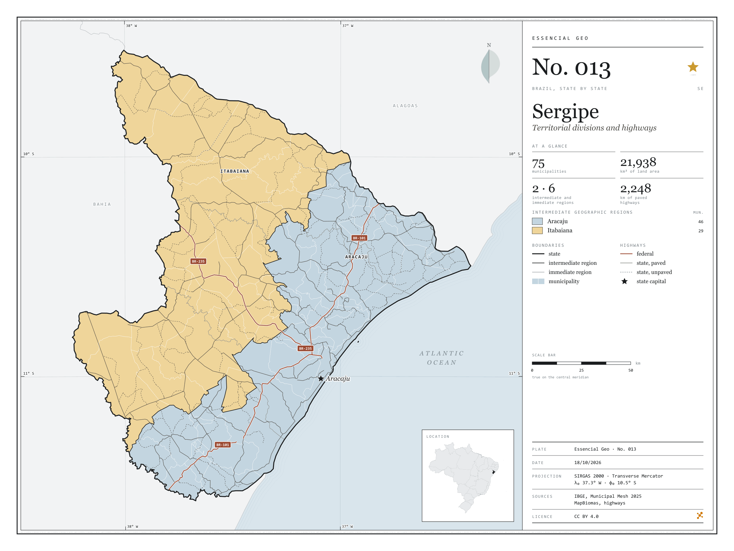
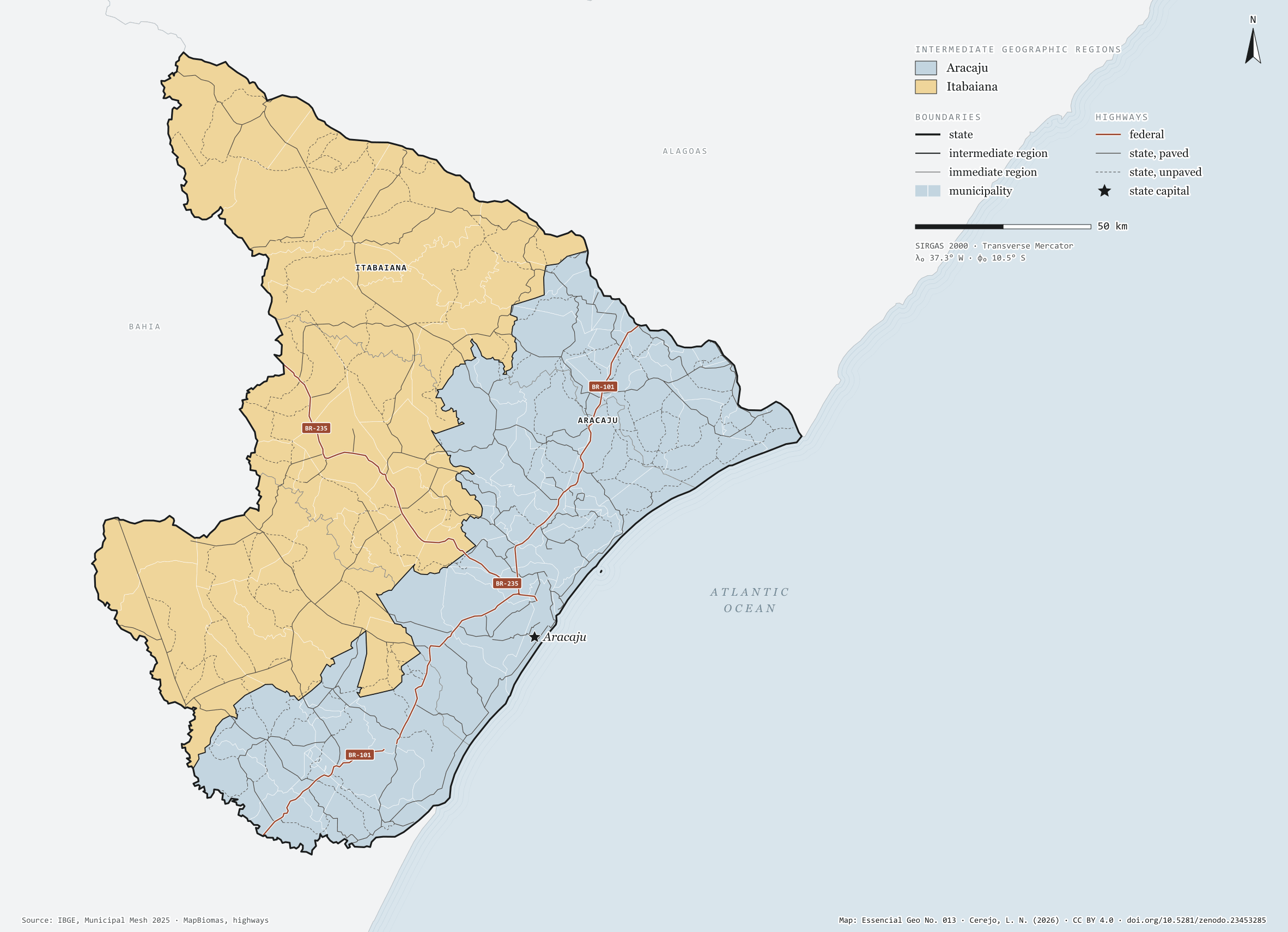
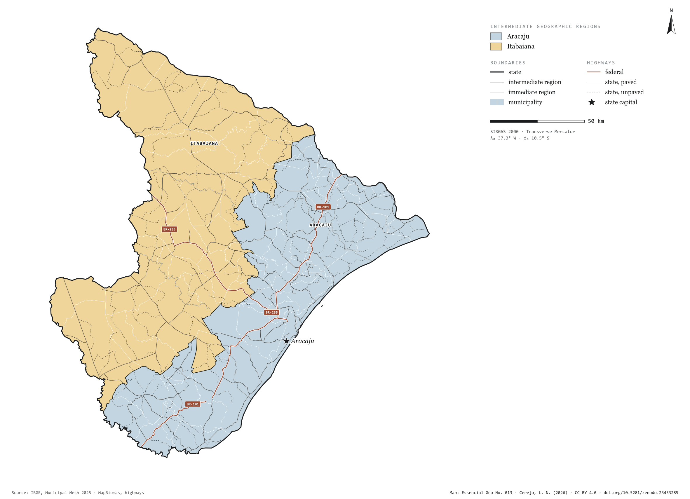
Fig. 013Sergipe state (SE)EPSG:4674Source: IBGE, MapBiomas, Natural Earth
Sergipe has 75 municipalities across 22,000 km², 0.3 per cent of Brazil. IBGE groups them into 6 immediate regions, drawn around the towns that supply jobs, trade and services to their surroundings, and into 2 intermediate regions that tie those networks together. Aracaju is the intermediate region with the most municipalities (46); Itabaiana, the one with the fewest (29). The largest municipality is Canindé de São Francisco (1,080 km²); the smallest, General Maynard (20 km²). Part of the series “Brazil, state by state”: a clean base, with official boundaries and the road network, to start a map without losing the first afternoon gathering files.
Technical record · downloads · citation
At a glance
Municipalities per intermediate region (municipalities)
Aracaju46
Itabaiana29
Area
21,938km²
Largest municipality: Canindé de São Francisco (1,080 km²); smallest: General Maynard (20 km²)
Paved highways
2,248km
316 km federal and 3,751 km state highways, paved or not
Layers
municipiospolygon75 municipalities, with IBGE code, regions, urban concentration and area (km²)
regioes_intermediariaspolygon2 intermediate geographic regions
regioes_imediataspolygon6 immediate geographic regions
limite_estadualpolygonBoundary of the federative unit
rodoviaslineFederal and state highways: route number, surface, physical status, carriageways
capitalpointIndicative point for the capital (not the exact seat)
The map without a frame, with legend, scale, reference system and credit written on it: ready for papers, lectures and slides. In two versions: with the basemap (neighbours and sea) or only the mapped area, on white.
CEREJO, Lucas Nakamura. Sergipe: divisão territorial e rodovias. Versão 1.0.0. [S. l.]: Zenodo, 2026. Conjunto de dados. DOI: 10.5281/zenodo.23453285. Disponível em: https://doi.org/10.5281/zenodo.23453285. Acesso em: 10 nov. 2026.
Cerejo, L. N. (2026). Sergipe: divisão territorial e rodovias [Sergipe: Territorial divisions and highways] (Version 1.0.0) [Data set]. Zenodo. https://doi.org/10.5281/zenodo.23453285
@dataset{cerejo2026_estado_sergipe,
  author    = {Cerejo, Lucas Nakamura},
  title     = {Sergipe: Divisão territorial e rodovias},
  year      = {2026},
  publisher = {Zenodo},
  version   = {1.0.0},
  doi       = {10.5281/zenodo.23453285},
  url       = {https://doi.org/10.5281/zenodo.23453285},
  language  = {portuguese},
  note      = {English title: Sergipe: Territorial divisions and highways. Licence CC BY 4.0}
}