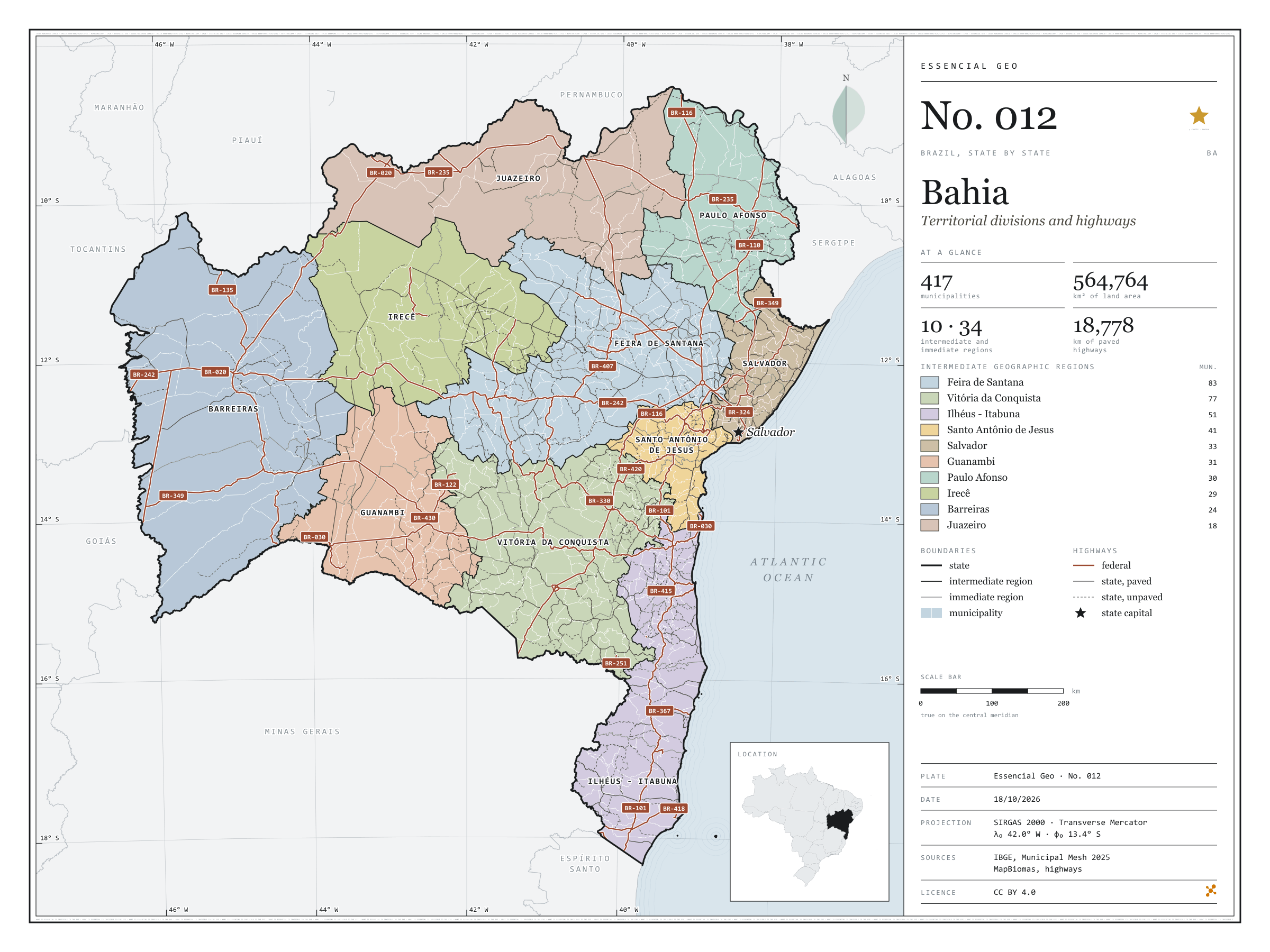
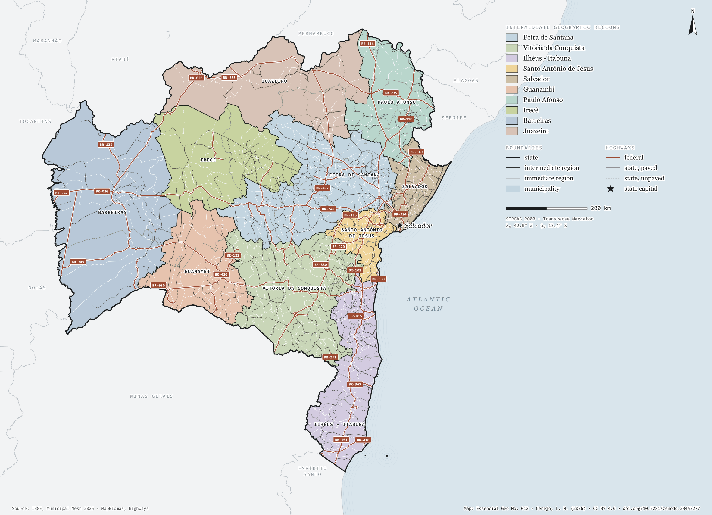
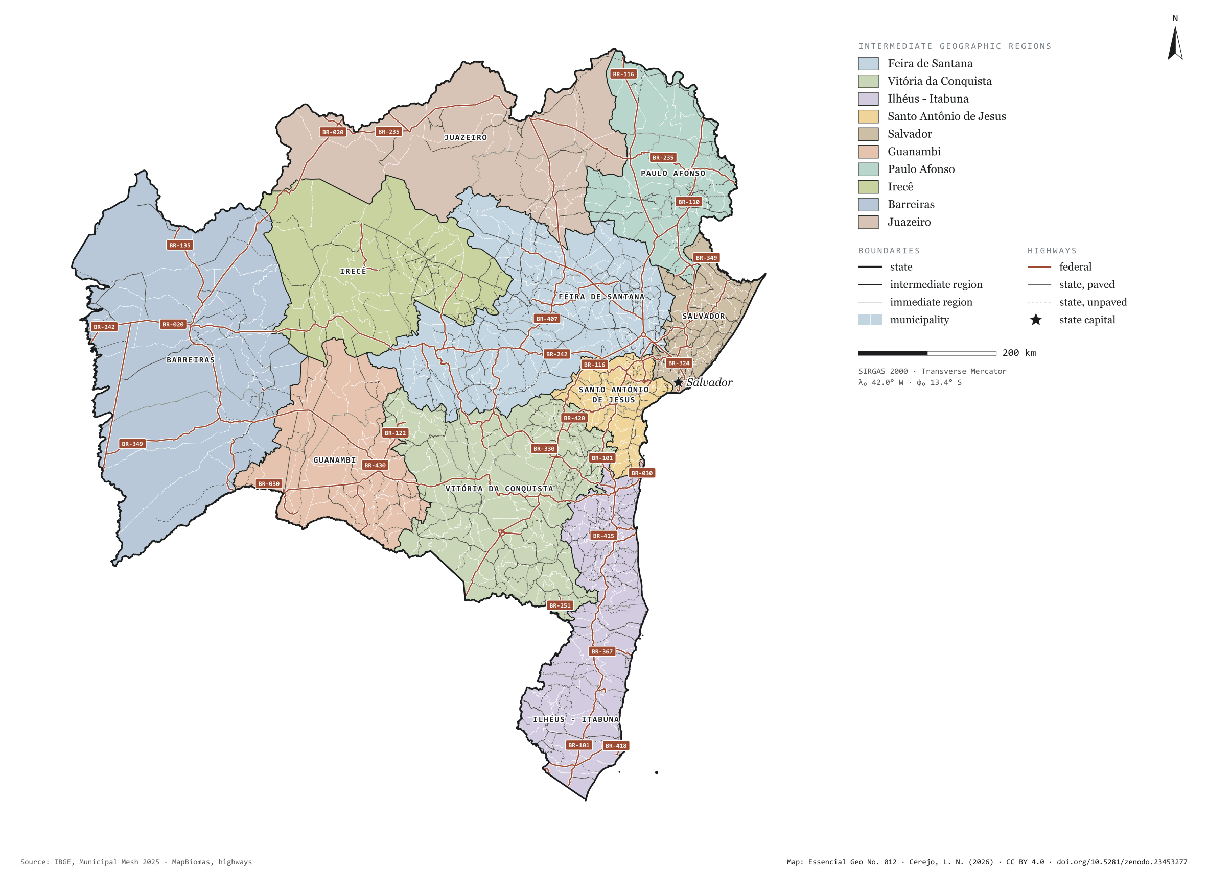
Fig. 012Bahia state (BA)EPSG:4674Source: IBGE, MapBiomas, Natural Earth
Bahia has 417 municipalities across 565,000 km², 6.6 per cent of Brazil. IBGE groups them into 34 immediate regions, drawn around the towns that supply jobs, trade and services to their surroundings, and into 10 intermediate regions that tie those networks together. Feira de Santana is the intermediate region with the most municipalities (83); Juazeiro, the one with the fewest (18). The largest municipality is Formosa do Rio Preto (15,634 km²); the smallest, Madre de Deus (33 km²). Part of the series “Brazil, state by state”: a clean base, with official boundaries and the road network, to start a map without losing the first afternoon gathering files.
Technical record · downloads · citation
At a glance
Municipalities per intermediate region (municipalities)
Feira de Santana83
Vitória da Conquista77
Ilhéus - Itabuna51
Santo Antônio de Jesus41
Salvador33
Guanambi31
Paulo Afonso30
Irecê29
Barreiras24
Juazeiro18
Area
564,764km²
Largest municipality: Formosa do Rio Preto (15,634 km²); smallest: Madre de Deus (33 km²)
Paved highways
18,778km
8,906 km federal and 21,586 km state highways, paved or not
Layers
municipiospolygon417 municipalities, with IBGE code, regions, urban concentration and area (km²)
regioes_intermediariaspolygon10 intermediate geographic regions
regioes_imediataspolygon34 immediate geographic regions
limite_estadualpolygonBoundary of the federative unit
rodoviaslineFederal and state highways: route number, surface, physical status, carriageways
capitalpointIndicative point for the capital (not the exact seat)
The map without a frame, with legend, scale, reference system and credit written on it: ready for papers, lectures and slides. In two versions: with the basemap (neighbours and sea) or only the mapped area, on white.
CEREJO, Lucas Nakamura. Bahia: divisão territorial e rodovias. Versão 1.0.0. [S. l.]: Zenodo, 2026. Conjunto de dados. DOI: 10.5281/zenodo.23453277. Disponível em: https://doi.org/10.5281/zenodo.23453277. Acesso em: 10 nov. 2026.
Cerejo, L. N. (2026). Bahia: divisão territorial e rodovias [Bahia: Territorial divisions and highways] (Version 1.0.0) [Data set]. Zenodo. https://doi.org/10.5281/zenodo.23453277
@dataset{cerejo2026_estado_bahia,
  author    = {Cerejo, Lucas Nakamura},
  title     = {Bahia: Divisão territorial e rodovias},
  year      = {2026},
  publisher = {Zenodo},
  version   = {1.0.0},
  doi       = {10.5281/zenodo.23453277},
  url       = {https://doi.org/10.5281/zenodo.23453277},
  language  = {portuguese},
  note      = {English title: Bahia: Territorial divisions and highways. Licence CC BY 4.0}
}
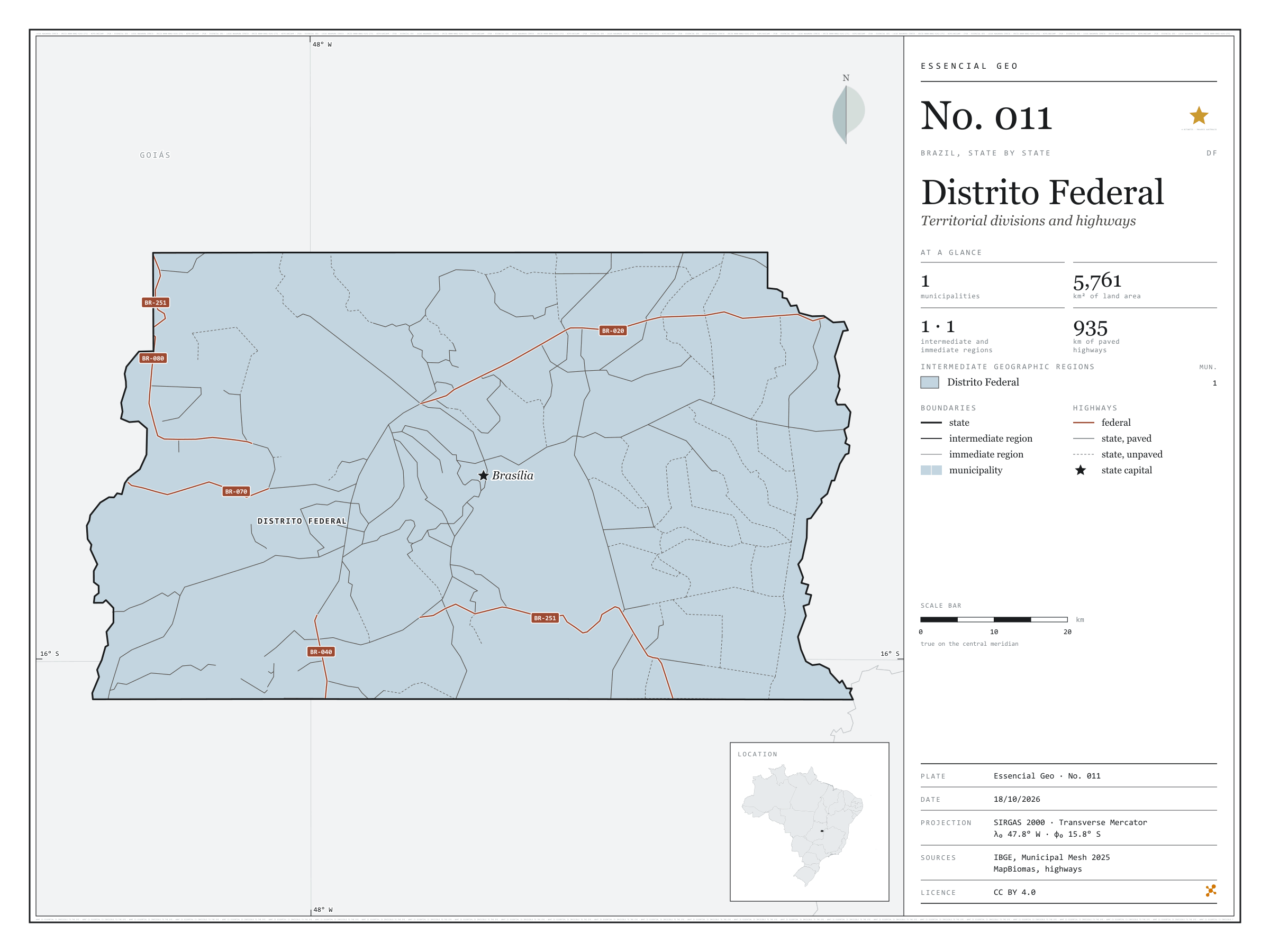
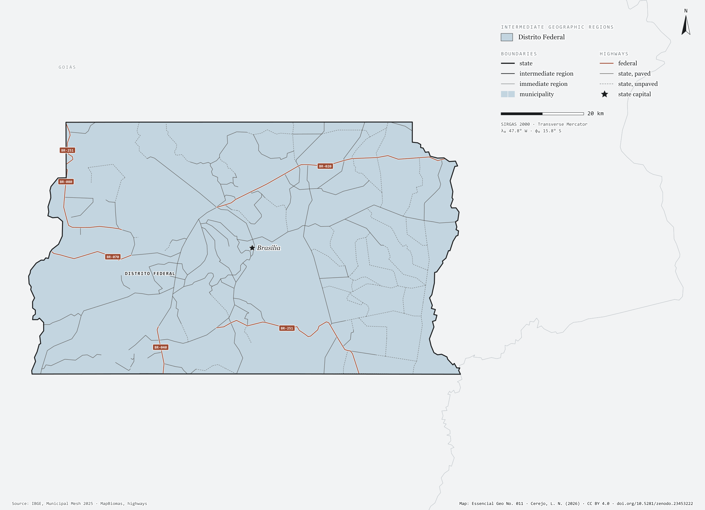
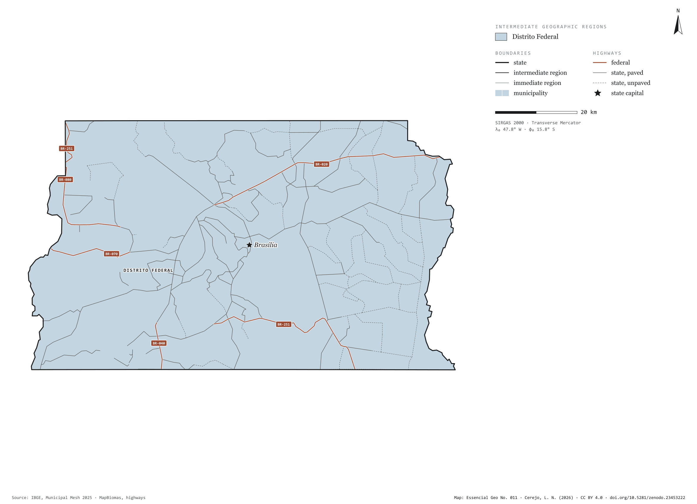
Fig. 011Federal District (DF)EPSG:4674Source: IBGE, MapBiomas, Natural Earth
The Federal District is not divided into municipalities: in the IBGE mesh it is a single one, Brasília, with 5,761 km². On its own it is also one immediate region and one intermediate region. The smallest federative unit sits on the Central Plateau, between Goiás and Minas Gerais, and the radial federal highways, numbered BR-010 to BR-080, start from it. Part of the series “Brazil, state by state”: a clean base, with official boundaries and the road network, to start a map without losing the first afternoon gathering files.
Technical record · downloads · citation
At a glance
Municipalities per intermediate region (municipalities)
Distrito Federal1
Area
5,761km²
Paved highways
935km
175 km federal and 1,230 km state highways, paved or not
Layers
municipiospolygon1 municipality, with IBGE code, regions, urban concentration and area (km²)
regioes_intermediariaspolygon1 intermediate geographic region
regioes_imediataspolygon1 immediate geographic region
limite_estadualpolygonBoundary of the federative unit
rodoviaslineFederal and state highways: route number, surface, physical status, carriageways
capitalpointIndicative point for the capital (not the exact seat)
The map without a frame, with legend, scale, reference system and credit written on it: ready for papers, lectures and slides. In two versions: with the basemap (neighbours and sea) or only the mapped area, on white.
CEREJO, Lucas Nakamura. Distrito Federal: divisão territorial e rodovias. Versão 1.0.0. [S. l.]: Zenodo, 2026. Conjunto de dados. DOI: 10.5281/zenodo.23453222. Disponível em: https://doi.org/10.5281/zenodo.23453222. Acesso em: 10 nov. 2026.
Cerejo, L. N. (2026). Distrito Federal: divisão territorial e rodovias [Distrito Federal: Territorial divisions and highways] (Version 1.0.0) [Data set]. Zenodo. https://doi.org/10.5281/zenodo.23453222
@dataset{cerejo2026_distrito_federal,
  author    = {Cerejo, Lucas Nakamura},
  title     = {Distrito Federal: Divisão territorial e rodovias},
  year      = {2026},
  publisher = {Zenodo},
  version   = {1.0.0},
  doi       = {10.5281/zenodo.23453222},
  url       = {https://doi.org/10.5281/zenodo.23453222},
  language  = {portuguese},
  note      = {English title: Distrito Federal: Territorial divisions and highways. Licence CC BY 4.0}
}
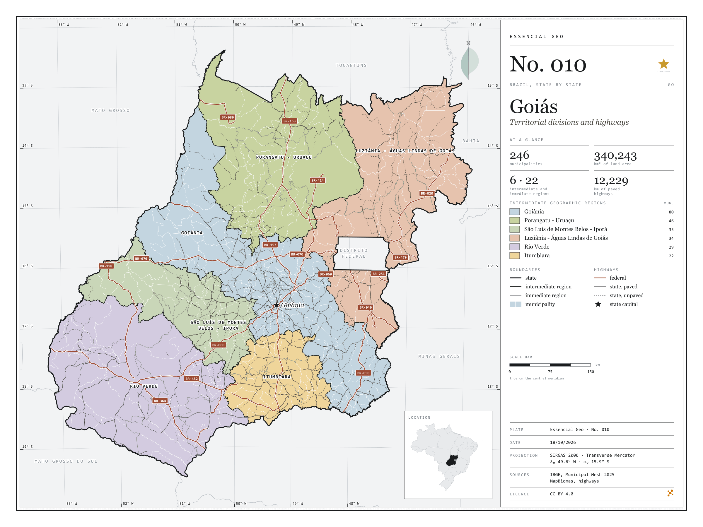
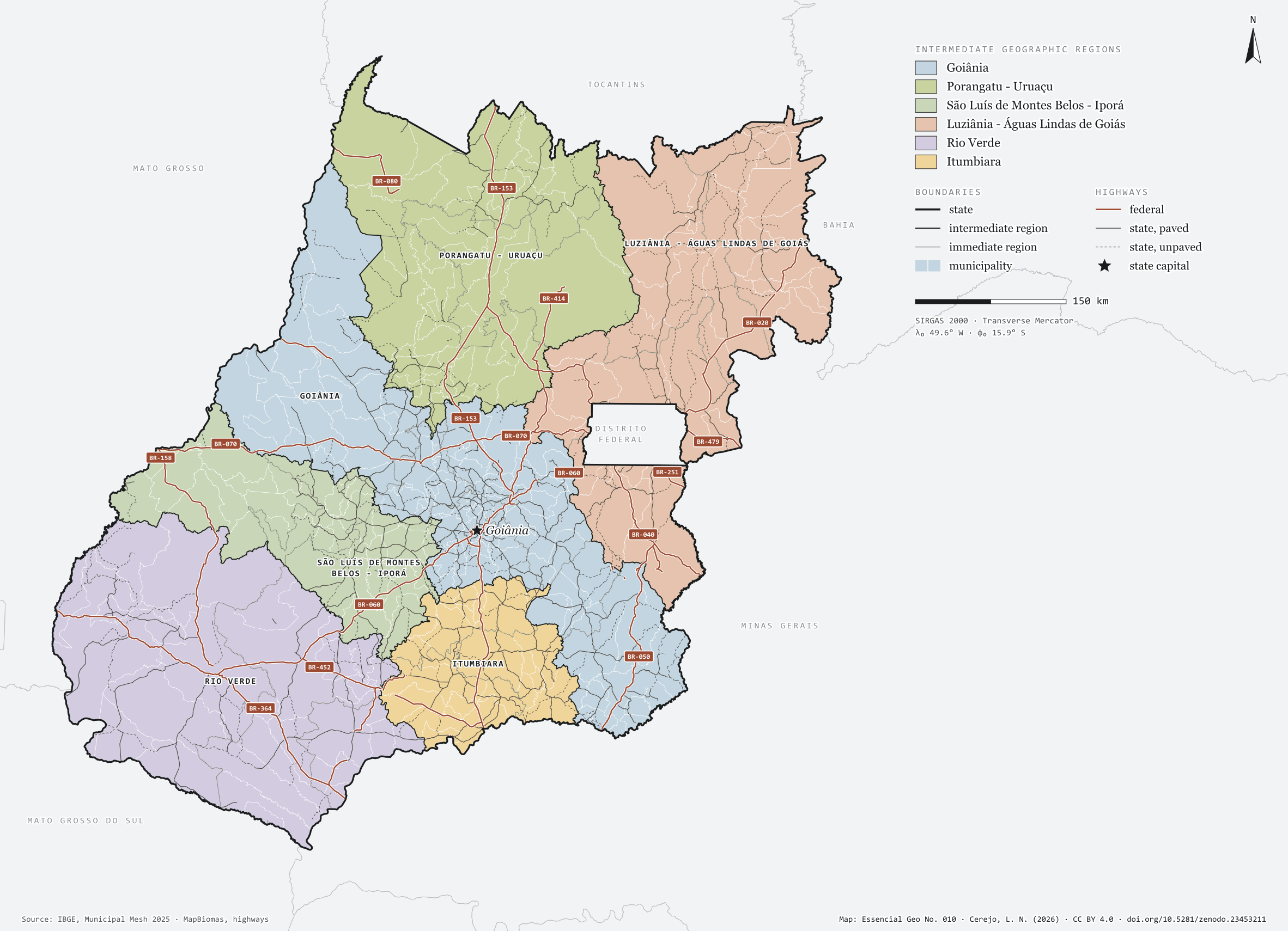
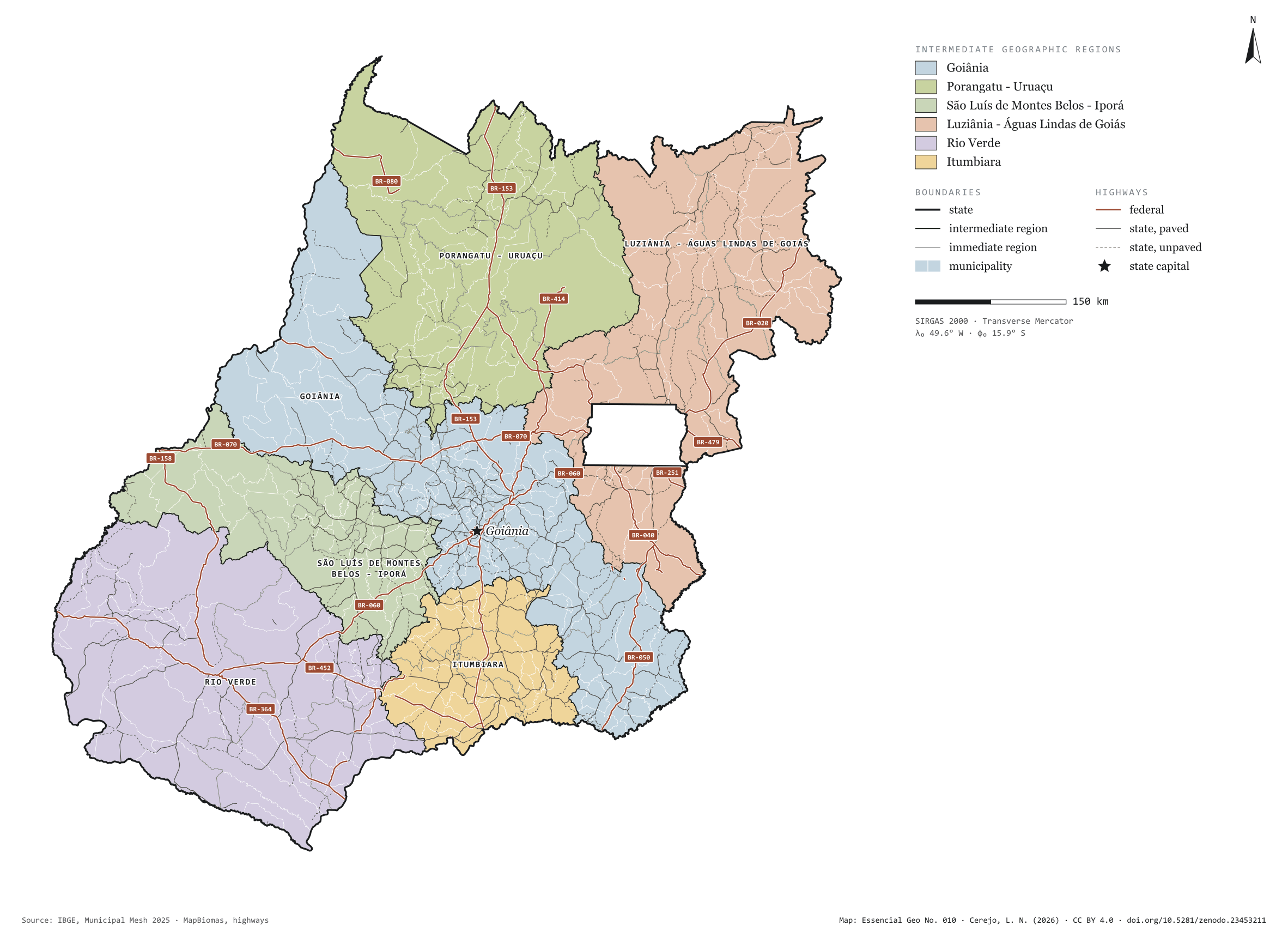
Fig. 010Goiás state (GO)EPSG:4674Source: IBGE, MapBiomas, Natural Earth
Goiás has 246 municipalities across 340,000 km², 4.0 per cent of Brazil. IBGE groups them into 22 immediate regions, drawn around the towns that supply jobs, trade and services to their surroundings, and into 6 intermediate regions that tie those networks together. Goiânia is the intermediate region with the most municipalities (80); Itumbiara, the one with the fewest (22). The largest municipality is Niquelândia (9,846 km²); the smallest, Anhanguera (56 km²). Part of the series “Brazil, state by state”: a clean base, with official boundaries and the road network, to start a map without losing the first afternoon gathering files.
Technical record · downloads · citation
At a glance
Municipalities per intermediate region (municipalities)
Goiânia80
Porangatu - Uruaçu46
São Luís de Montes Belos - Iporá35
Luziânia - Águas Lindas de Goiás34
Rio Verde29
Itumbiara22
Area
340,243km²
Largest municipality: Niquelândia (9,846 km²); smallest: Anhanguera (56 km²)
Paved highways
12,229km
3,903 km federal and 14,007 km state highways, paved or not
Layers
municipiospolygon246 municipalities, with IBGE code, regions, urban concentration and area (km²)
regioes_intermediariaspolygon6 intermediate geographic regions
regioes_imediataspolygon22 immediate geographic regions
limite_estadualpolygonBoundary of the federative unit
rodoviaslineFederal and state highways: route number, surface, physical status, carriageways
capitalpointIndicative point for the capital (not the exact seat)
The map without a frame, with legend, scale, reference system and credit written on it: ready for papers, lectures and slides. In two versions: with the basemap (neighbours and sea) or only the mapped area, on white.
CEREJO, Lucas Nakamura. Goiás: divisão territorial e rodovias. Versão 1.0.0. [S. l.]: Zenodo, 2026. Conjunto de dados. DOI: 10.5281/zenodo.23453211. Disponível em: https://doi.org/10.5281/zenodo.23453211. Acesso em: 10 nov. 2026.
Cerejo, L. N. (2026). Goiás: divisão territorial e rodovias [Goiás: Territorial divisions and highways] (Version 1.0.0) [Data set]. Zenodo. https://doi.org/10.5281/zenodo.23453211
@dataset{cerejo2026_estado_goias,
  author    = {Cerejo, Lucas Nakamura},
  title     = {Goiás: Divisão territorial e rodovias},
  year      = {2026},
  publisher = {Zenodo},
  version   = {1.0.0},
  doi       = {10.5281/zenodo.23453211},
  url       = {https://doi.org/10.5281/zenodo.23453211},
  language  = {portuguese},
  note      = {English title: Goiás: Territorial divisions and highways. Licence CC BY 4.0}
}
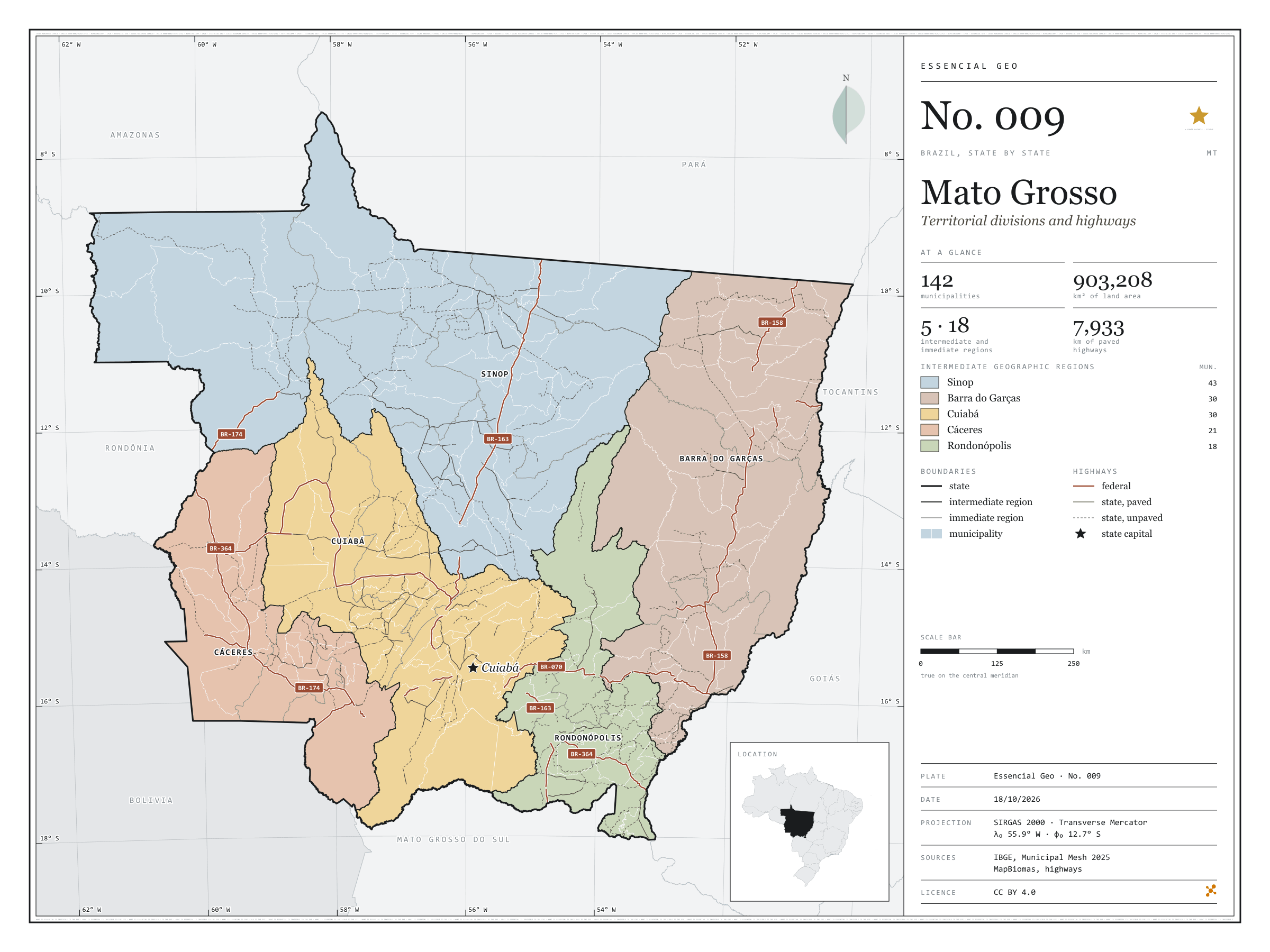
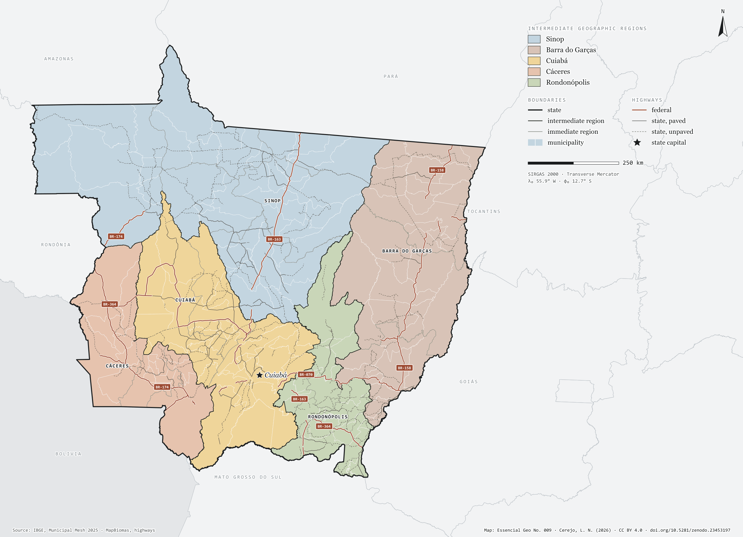
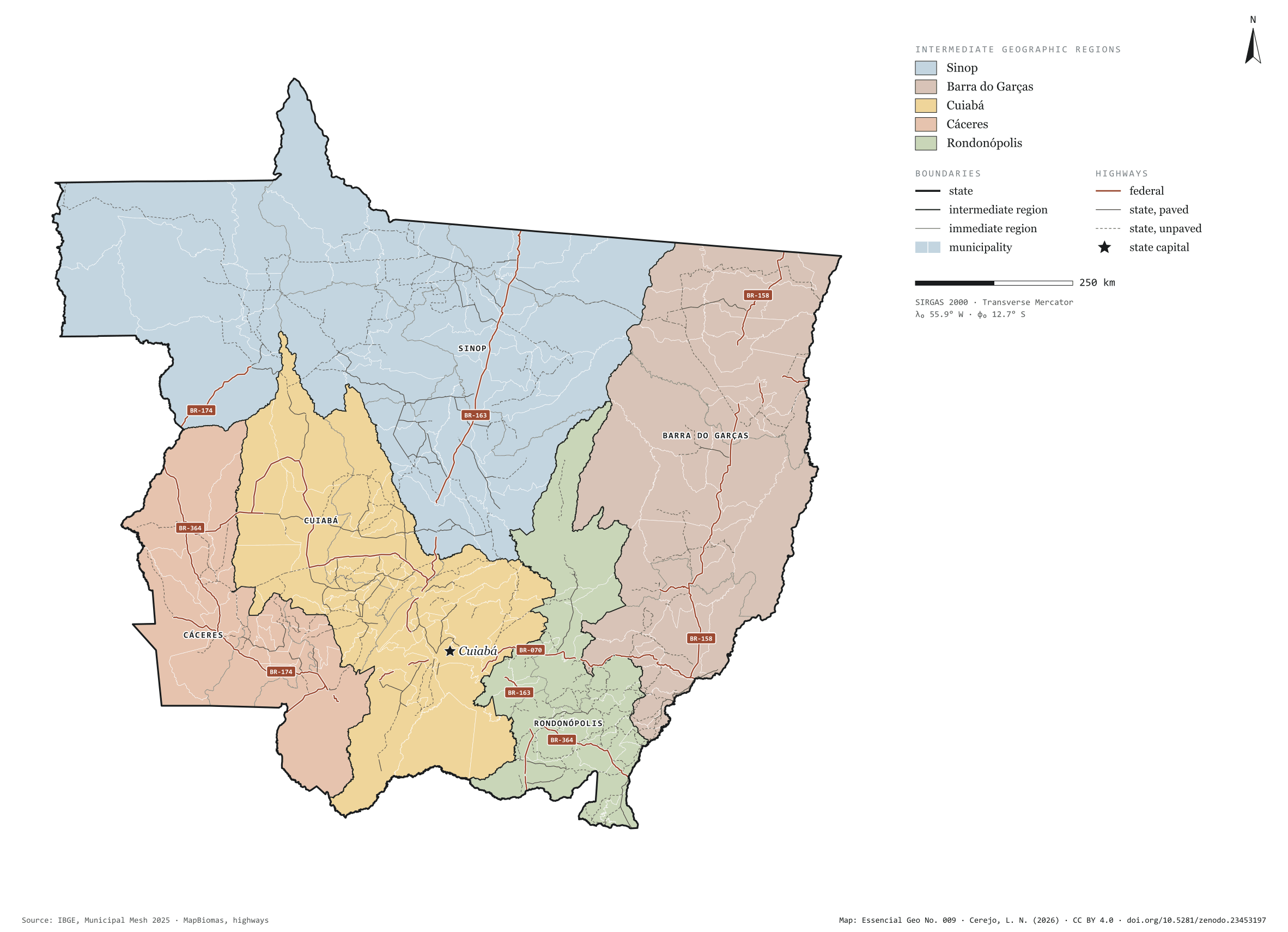
Fig. 009Mato Grosso state (MT)EPSG:4674Source: IBGE, MapBiomas, Natural Earth
Mato Grosso has 142 municipalities across 903,000 km², 10.6 per cent of Brazil. IBGE groups them into 18 immediate regions, drawn around the towns that supply jobs, trade and services to their surroundings, and into 5 intermediate regions that tie those networks together. Sinop is the intermediate region with the most municipalities (43); Rondonópolis, the one with the fewest (18). The largest municipality is Colniza (27,960 km²); the smallest, São Pedro da Cipa (344 km²). Part of the series “Brazil, state by state”: a clean base, with official boundaries and the road network, to start a map without losing the first afternoon gathering files.
Technical record · downloads · citation
At a glance
Municipalities per intermediate region (municipalities)
Sinop43
Barra do Garças30
Cuiabá30
Cáceres21
Rondonópolis18
Area
903,208km²
Largest municipality: Colniza (27,960 km²); smallest: São Pedro da Cipa (344 km²)
Paved highways
7,933km
3,893 km federal and 15,684 km state highways, paved or not
Layers
municipiospolygon142 municipalities, with IBGE code, regions, urban concentration and area (km²)
regioes_intermediariaspolygon5 intermediate geographic regions
regioes_imediataspolygon18 immediate geographic regions
limite_estadualpolygonBoundary of the federative unit
rodoviaslineFederal and state highways: route number, surface, physical status, carriageways
capitalpointIndicative point for the capital (not the exact seat)
The map without a frame, with legend, scale, reference system and credit written on it: ready for papers, lectures and slides. In two versions: with the basemap (neighbours and sea) or only the mapped area, on white.
CEREJO, Lucas Nakamura. Mato Grosso: divisão territorial e rodovias. Versão 1.0.0. [S. l.]: Zenodo, 2026. Conjunto de dados. DOI: 10.5281/zenodo.23453197. Disponível em: https://doi.org/10.5281/zenodo.23453197. Acesso em: 10 nov. 2026.
Cerejo, L. N. (2026). Mato Grosso: divisão territorial e rodovias [Mato Grosso: Territorial divisions and highways] (Version 1.0.0) [Data set]. Zenodo. https://doi.org/10.5281/zenodo.23453197
@dataset{cerejo2026_estado_mato_grosso,
  author    = {Cerejo, Lucas Nakamura},
  title     = {Mato Grosso: Divisão territorial e rodovias},
  year      = {2026},
  publisher = {Zenodo},
  version   = {1.0.0},
  doi       = {10.5281/zenodo.23453197},
  url       = {https://doi.org/10.5281/zenodo.23453197},
  language  = {portuguese},
  note      = {English title: Mato Grosso: Territorial divisions and highways. Licence CC BY 4.0}
}
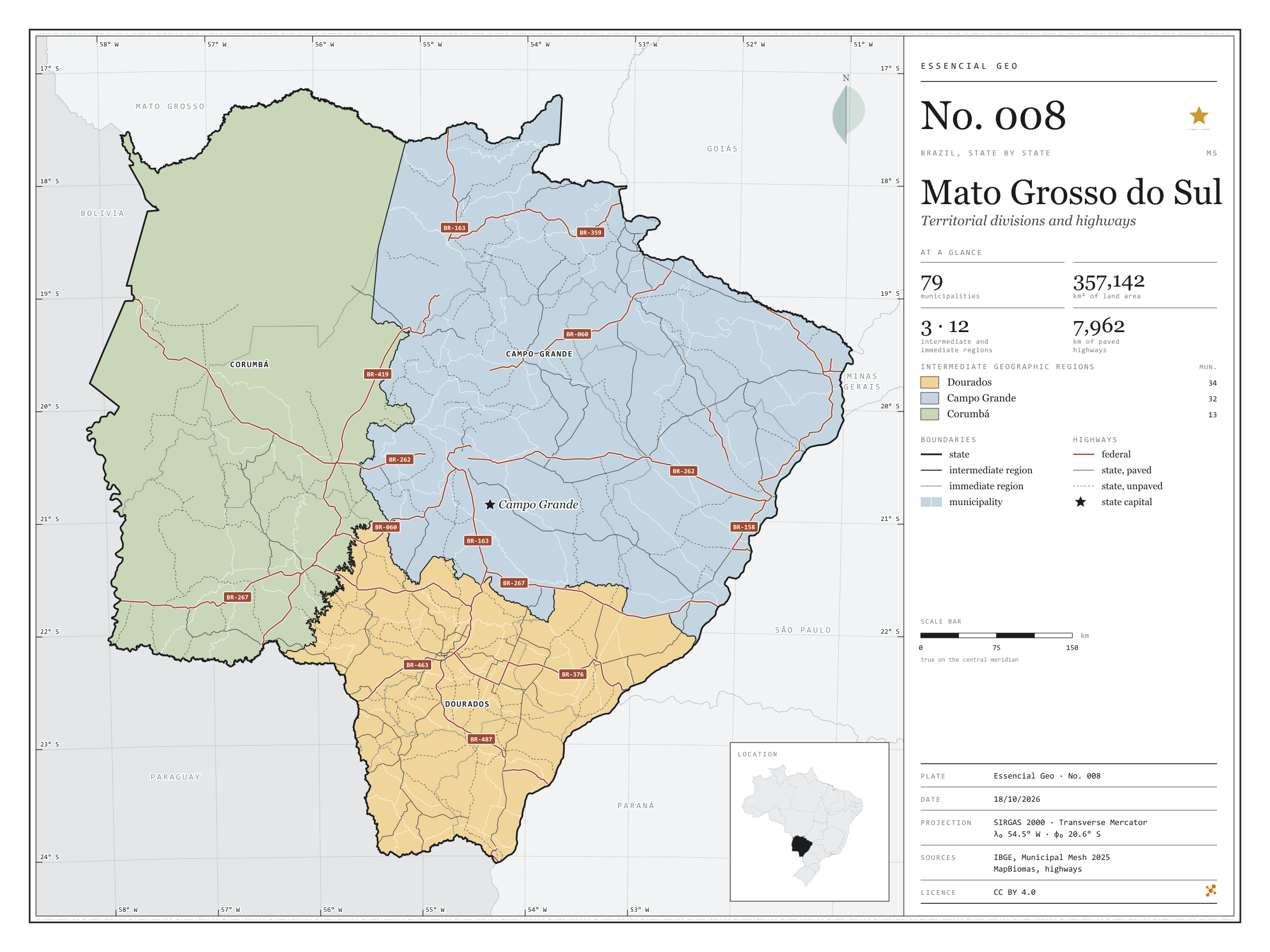
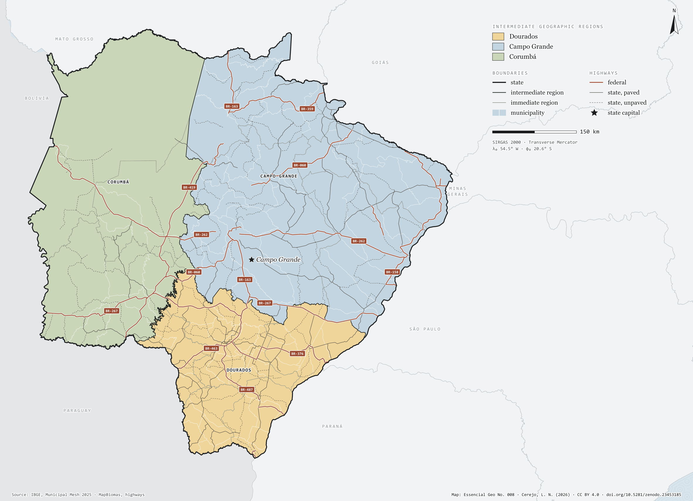
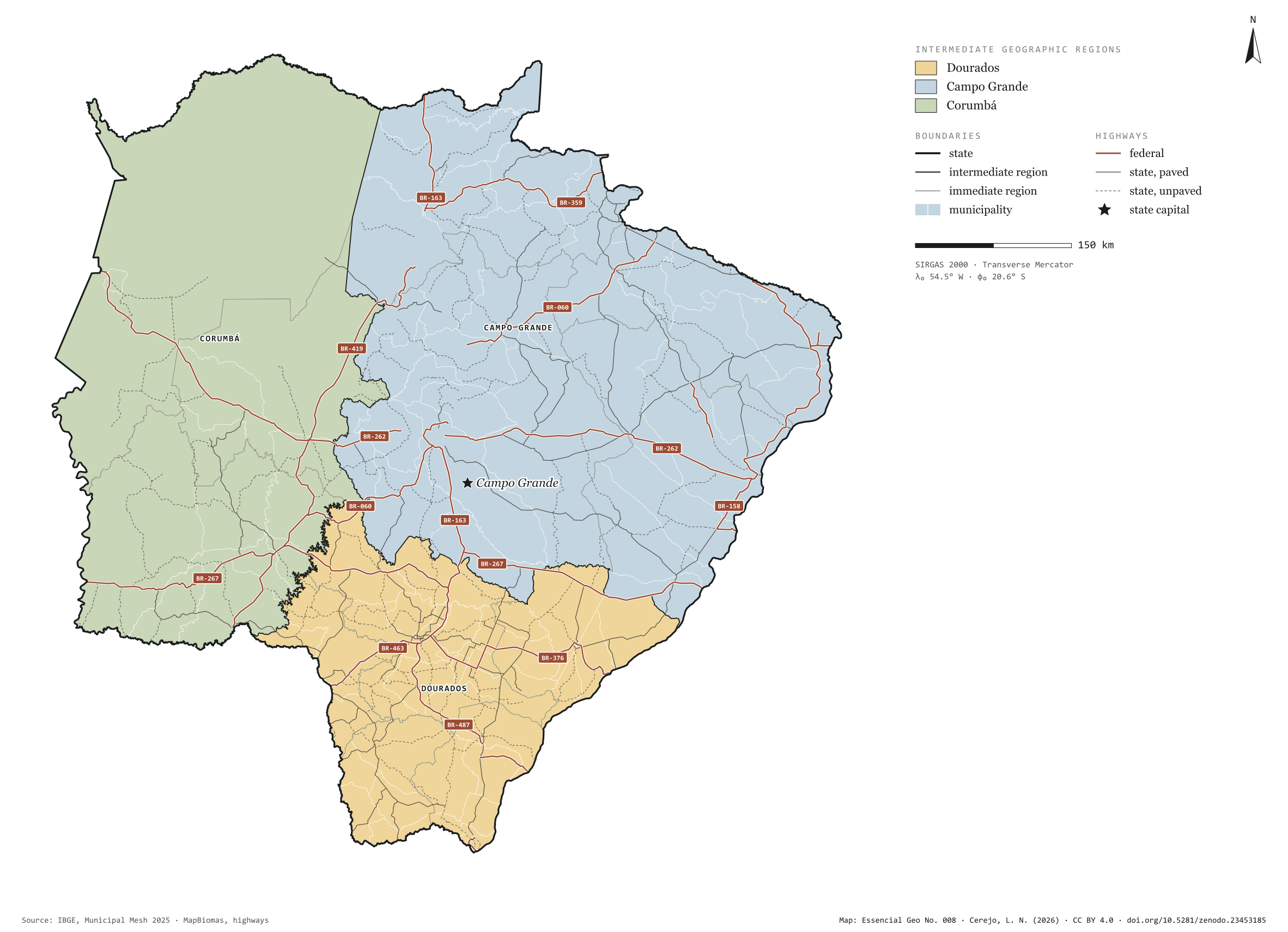
Fig. 008Mato Grosso do Sul state (MS)EPSG:4674Source: IBGE, MapBiomas, Natural Earth
Mato Grosso do Sul has 79 municipalities across 357,000 km², 4.2 per cent of Brazil. IBGE groups them into 12 immediate regions, drawn around the towns that supply jobs, trade and services to their surroundings, and into 3 intermediate regions that tie those networks together. Dourados is the intermediate region with the most municipalities (34); Corumbá, the one with the fewest (13). The largest municipality is Corumbá (64,431 km²); the smallest, Douradina (280 km²). Part of the series “Brazil, state by state”: a clean base, with official boundaries and the road network, to start a map without losing the first afternoon gathering files.
Technical record · downloads · citation
At a glance
Municipalities per intermediate region (municipalities)
Dourados34
Campo Grande32
Corumbá13
Area
357,142km²
Largest municipality: Corumbá (64,431 km²); smallest: Douradina (280 km²)
Paved highways
7,962km
3,798 km federal and 11,355 km state highways, paved or not
Layers
municipiospolygon79 municipalities, with IBGE code, regions, urban concentration and area (km²)
regioes_intermediariaspolygon3 intermediate geographic regions
regioes_imediataspolygon12 immediate geographic regions
limite_estadualpolygonBoundary of the federative unit
rodoviaslineFederal and state highways: route number, surface, physical status, carriageways
capitalpointIndicative point for the capital (not the exact seat)
The map without a frame, with legend, scale, reference system and credit written on it: ready for papers, lectures and slides. In two versions: with the basemap (neighbours and sea) or only the mapped area, on white.
CEREJO, Lucas Nakamura. Mato Grosso do Sul: divisão territorial e rodovias. Versão 1.0.0. [S. l.]: Zenodo, 2026. Conjunto de dados. DOI: 10.5281/zenodo.23453185. Disponível em: https://doi.org/10.5281/zenodo.23453185. Acesso em: 10 nov. 2026.
Cerejo, L. N. (2026). Mato Grosso do Sul: divisão territorial e rodovias [Mato Grosso do Sul: Territorial divisions and highways] (Version 1.0.0) [Data set]. Zenodo. https://doi.org/10.5281/zenodo.23453185
@dataset{cerejo2026_estado_mato_grosso_do_sul,
  author    = {Cerejo, Lucas Nakamura},
  title     = {Mato Grosso do Sul: Divisão territorial e rodovias},
  year      = {2026},
  publisher = {Zenodo},
  version   = {1.0.0},
  doi       = {10.5281/zenodo.23453185},
  url       = {https://doi.org/10.5281/zenodo.23453185},
  language  = {portuguese},
  note      = {English title: Mato Grosso do Sul: Territorial divisions and highways. Licence CC BY 4.0}
}
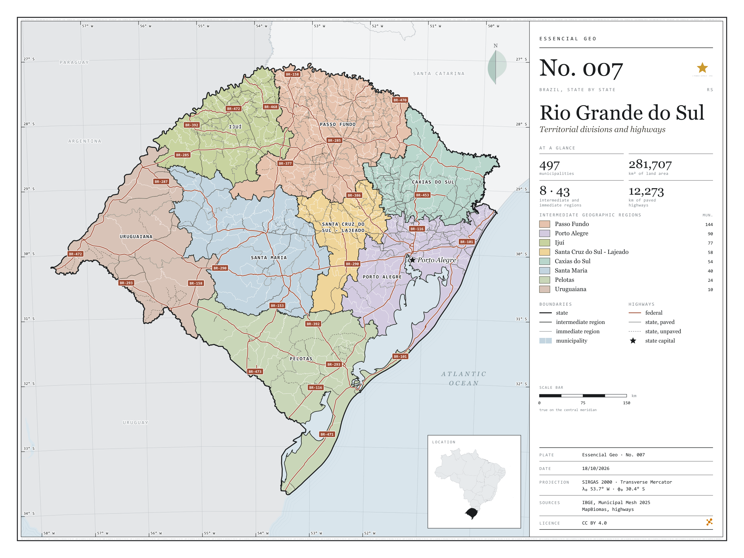
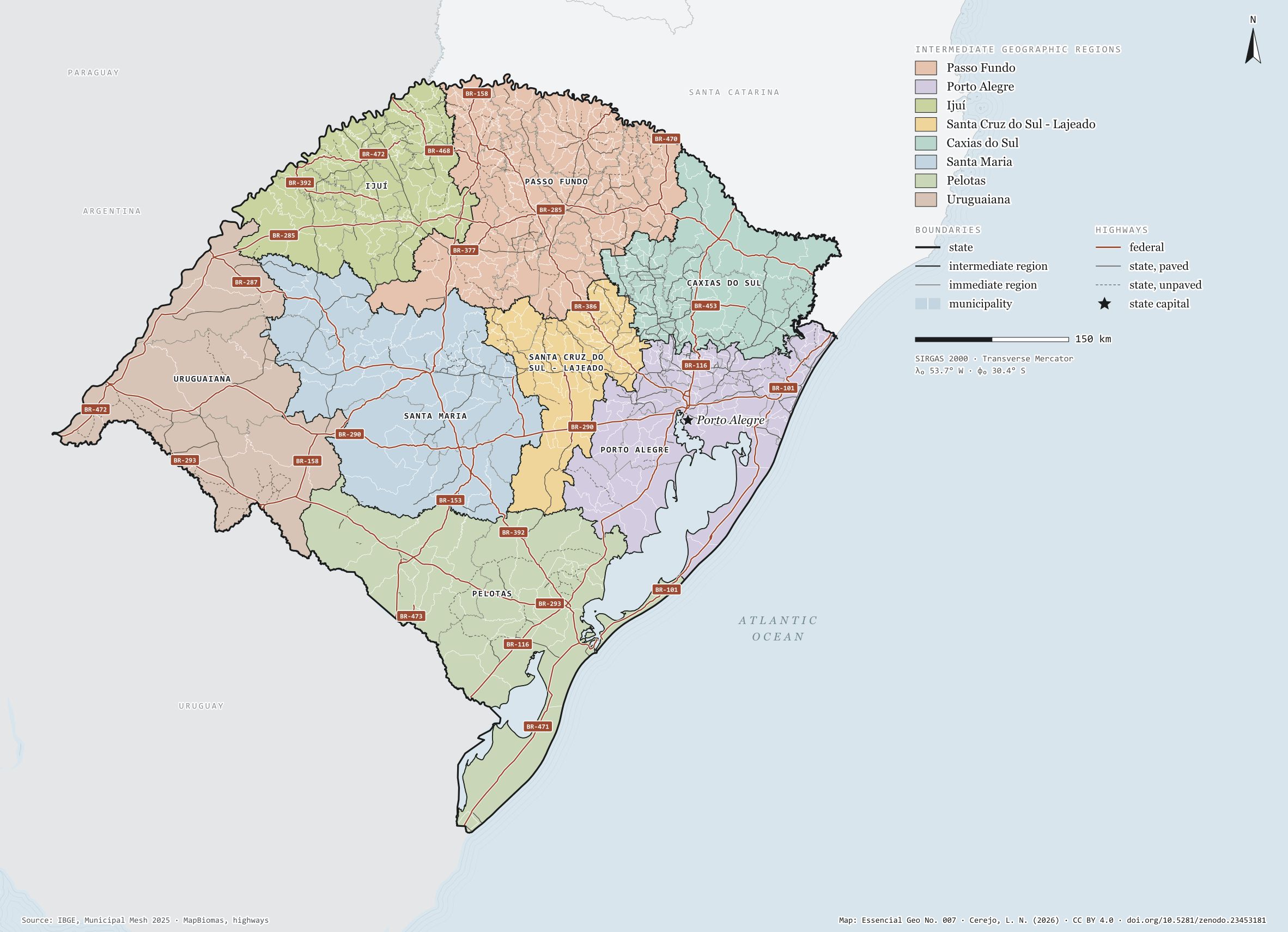
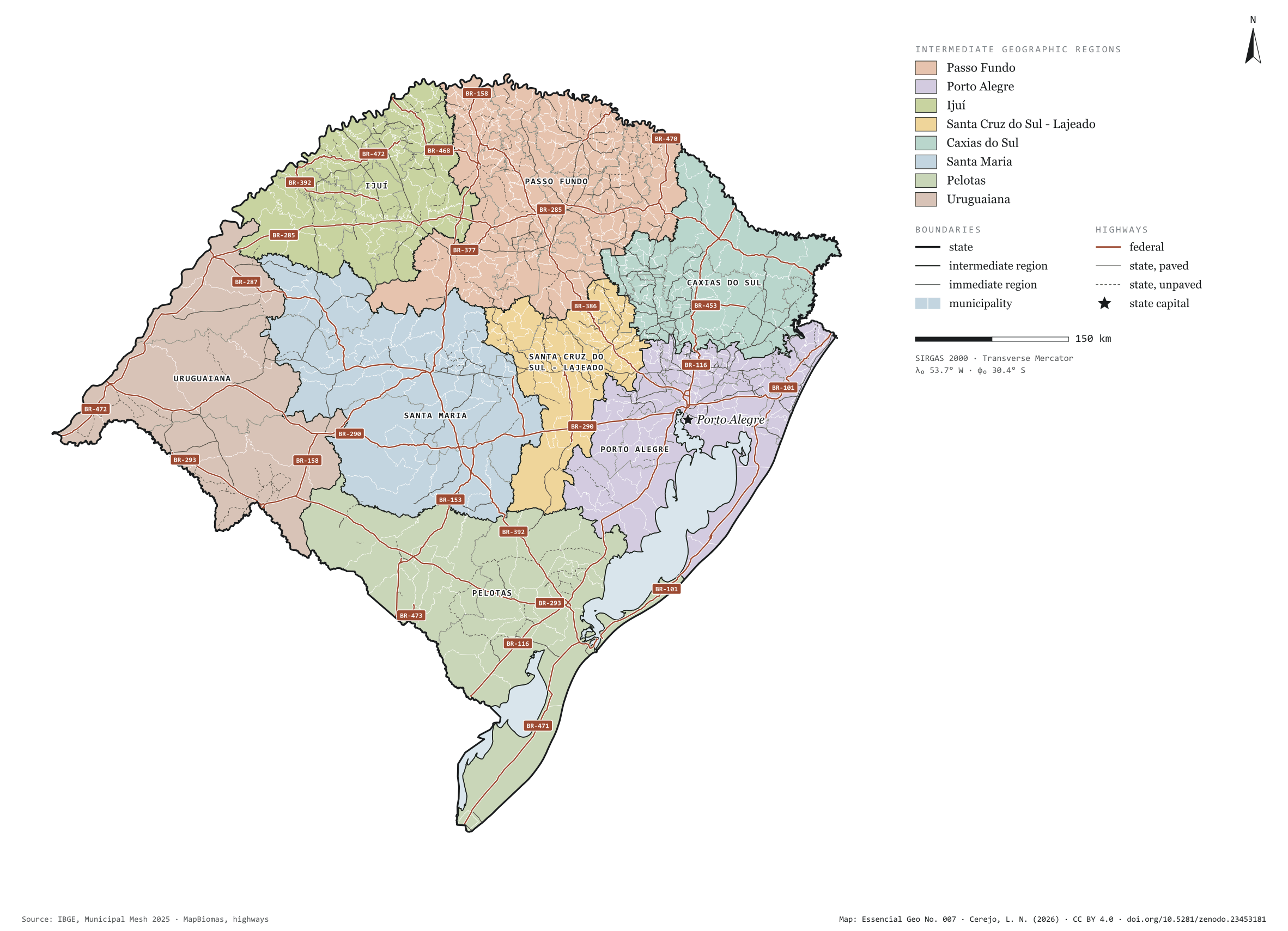
Fig. 007Rio Grande do Sul state (RS)EPSG:4674Source: IBGE, MapBiomas, Natural Earth
Rio Grande do Sul has 497 municipalities across 282,000 km², 3.3 per cent of Brazil. IBGE groups them into 43 immediate regions, drawn around the towns that supply jobs, trade and services to their surroundings, and into 8 intermediate regions that tie those networks together. Passo Fundo is the intermediate region with the most municipalities (144); Uruguaiana, the one with the fewest (10). The largest municipality is Alegrete (7,801 km²); the smallest, Esteio (28 km²). Part of the series “Brazil, state by state”: a clean base, with official boundaries and the road network, to start a map without losing the first afternoon gathering files.
Technical record · downloads · citation
At a glance
Municipalities per intermediate region (municipalities)
Passo Fundo144
Porto Alegre90
Ijuí77
Santa Cruz do Sul - Lajeado58
Caxias do Sul54
Santa Maria40
Pelotas24
Uruguaiana10
Area
281,707km²
Largest municipality: Alegrete (7,801 km²); smallest: Esteio (28 km²)
Paved highways
12,273km
5,906 km federal and 10,026 km state highways, paved or not
Layers
municipiospolygon497 municipalities, with IBGE code, regions, urban concentration and area (km²)
regioes_intermediariaspolygon8 intermediate geographic regions
regioes_imediataspolygon43 immediate geographic regions
limite_estadualpolygonBoundary of the federative unit
rodoviaslineFederal and state highways: route number, surface, physical status, carriageways
capitalpointIndicative point for the capital (not the exact seat)
The map without a frame, with legend, scale, reference system and credit written on it: ready for papers, lectures and slides. In two versions: with the basemap (neighbours and sea) or only the mapped area, on white.
CEREJO, Lucas Nakamura. Rio Grande do Sul: divisão territorial e rodovias. Versão 1.0.0. [S. l.]: Zenodo, 2026. Conjunto de dados. DOI: 10.5281/zenodo.23453181. Disponível em: https://doi.org/10.5281/zenodo.23453181. Acesso em: 10 nov. 2026.
Cerejo, L. N. (2026). Rio Grande do Sul: divisão territorial e rodovias [Rio Grande do Sul: Territorial divisions and highways] (Version 1.0.0) [Data set]. Zenodo. https://doi.org/10.5281/zenodo.23453181
@dataset{cerejo2026_estado_rio_grande_do_sul,
  author    = {Cerejo, Lucas Nakamura},
  title     = {Rio Grande do Sul: Divisão territorial e rodovias},
  year      = {2026},
  publisher = {Zenodo},
  version   = {1.0.0},
  doi       = {10.5281/zenodo.23453181},
  url       = {https://doi.org/10.5281/zenodo.23453181},
  language  = {portuguese},
  note      = {English title: Rio Grande do Sul: Territorial divisions and highways. Licence CC BY 4.0}
}
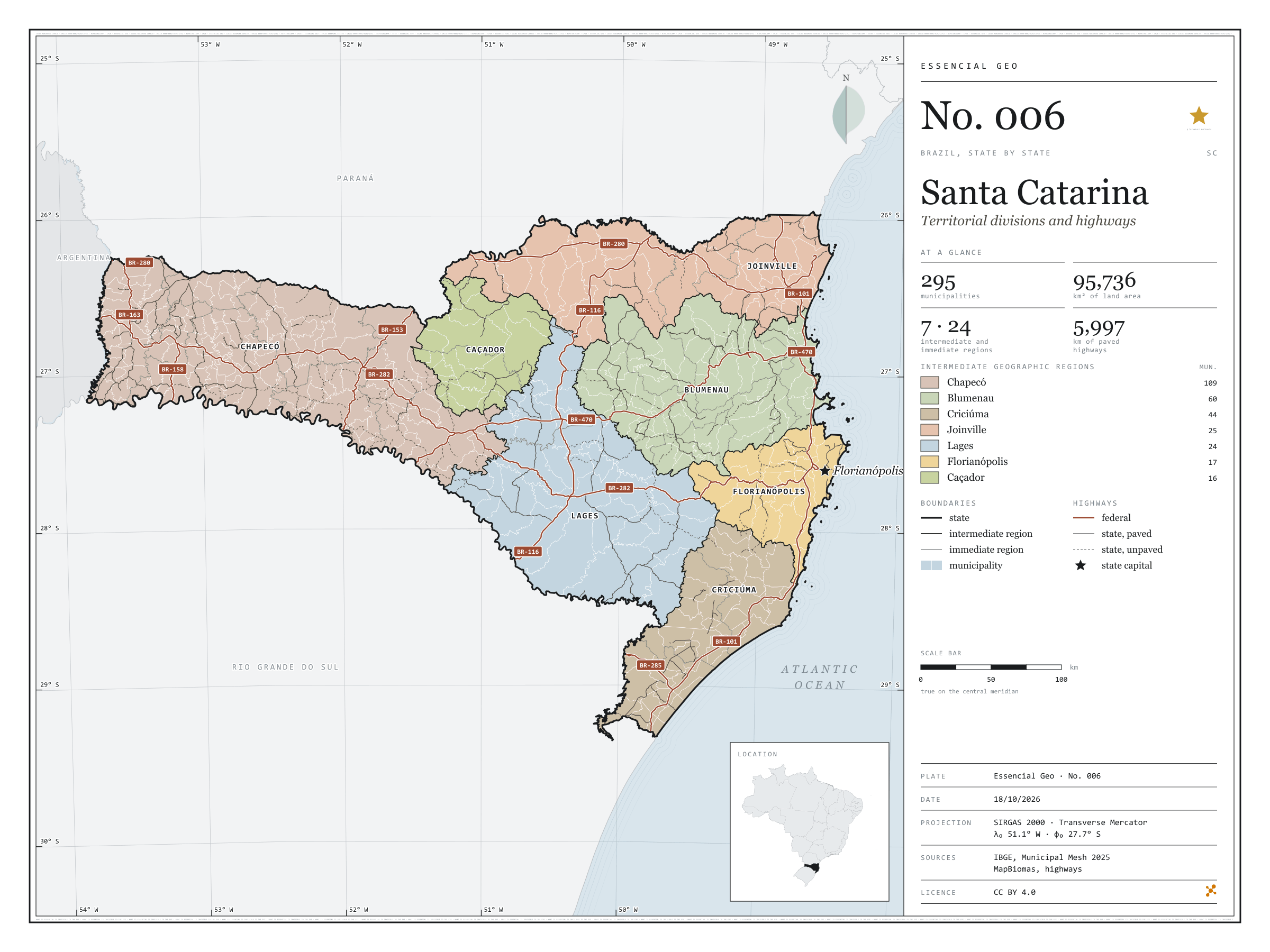
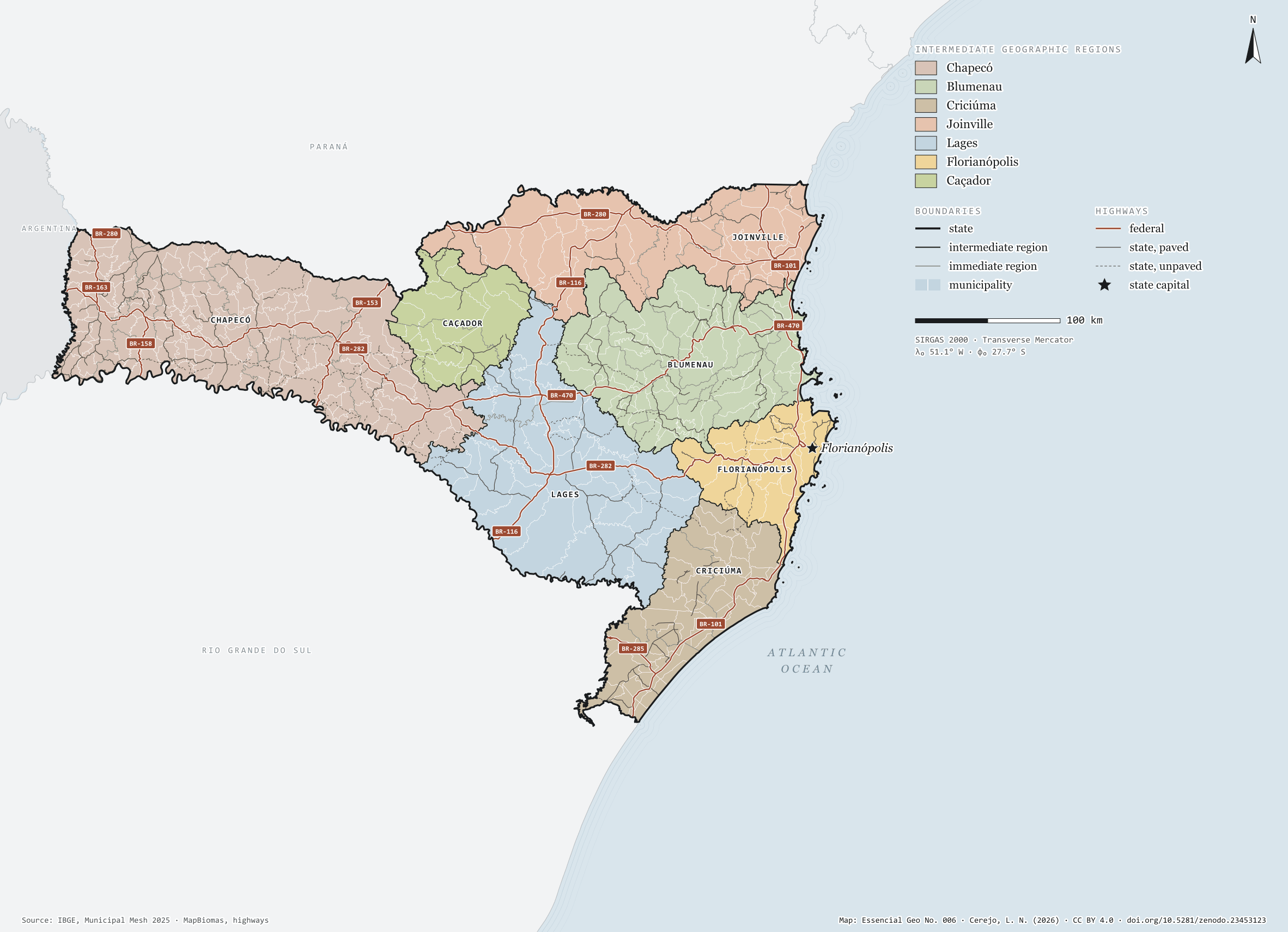
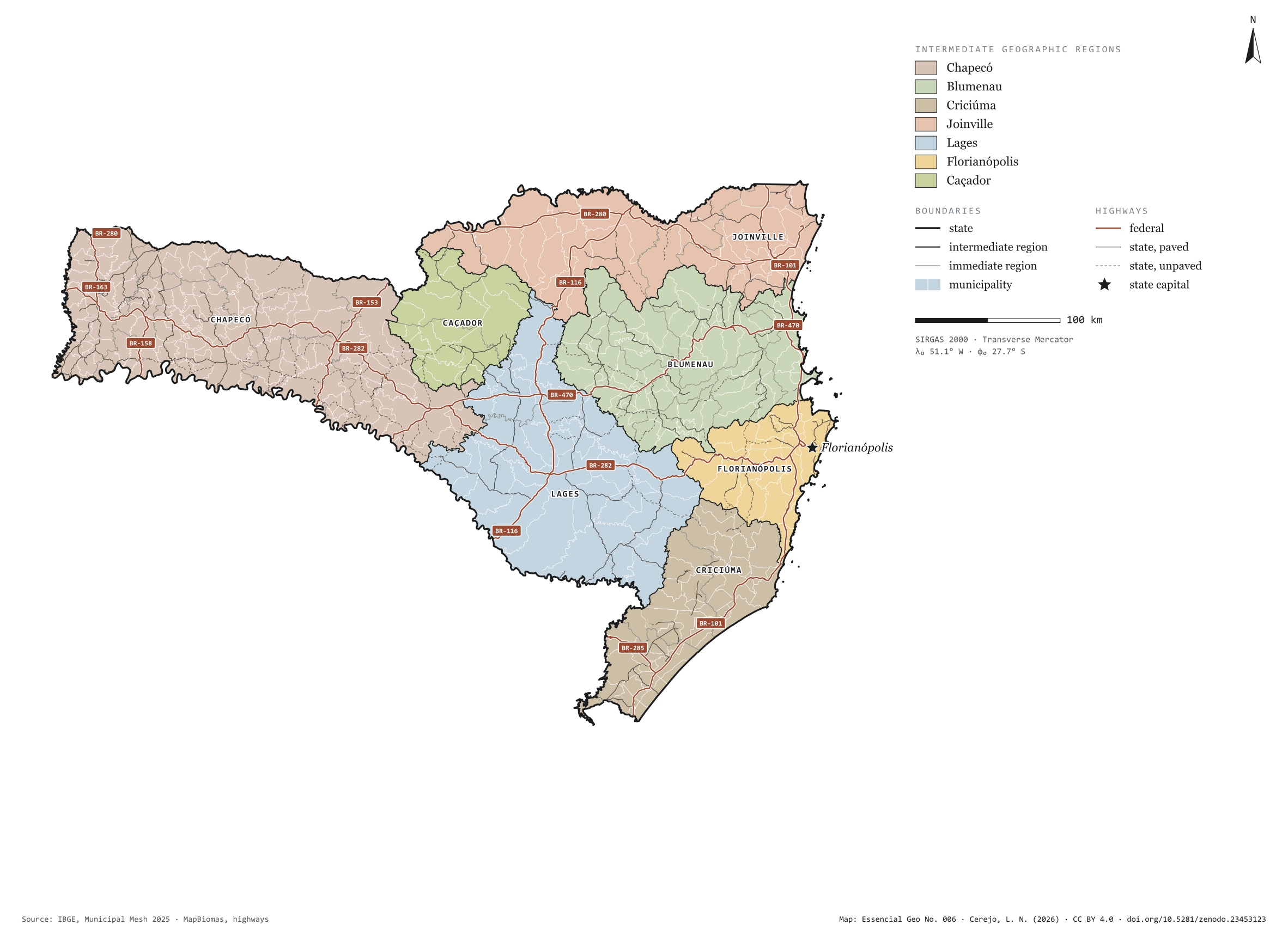
Fig. 006Santa Catarina state (SC)EPSG:4674Source: IBGE, MapBiomas, Natural Earth
Santa Catarina has 295 municipalities across 96,000 km², 1.1 per cent of Brazil. IBGE groups them into 24 immediate regions, drawn around the towns that supply jobs, trade and services to their surroundings, and into 7 intermediate regions that tie those networks together. Chapecó is the intermediate region with the most municipalities (109); Caçador, the one with the fewest (16). The largest municipality is Lages (2,638 km²); the smallest, Bombinhas (35 km²). Part of the series “Brazil, state by state”: a clean base, with official boundaries and the road network, to start a map without losing the first afternoon gathering files.
Technical record · downloads · citation
At a glance
Municipalities per intermediate region (municipalities)
Chapecó109
Blumenau60
Criciúma44
Joinville25
Lages24
Florianópolis17
Caçador16
Area
95,736km²
Largest municipality: Lages (2,638 km²); smallest: Bombinhas (35 km²)
Paved highways
5,997km
2,444 km federal and 5,271 km state highways, paved or not
Layers
municipiospolygon295 municipalities, with IBGE code, regions, urban concentration and area (km²)
regioes_intermediariaspolygon7 intermediate geographic regions
regioes_imediataspolygon24 immediate geographic regions
limite_estadualpolygonBoundary of the federative unit
rodoviaslineFederal and state highways: route number, surface, physical status, carriageways
capitalpointIndicative point for the capital (not the exact seat)
The map without a frame, with legend, scale, reference system and credit written on it: ready for papers, lectures and slides. In two versions: with the basemap (neighbours and sea) or only the mapped area, on white.
CEREJO, Lucas Nakamura. Santa Catarina: divisão territorial e rodovias. Versão 1.0.0. [S. l.]: Zenodo, 2026. Conjunto de dados. DOI: 10.5281/zenodo.23453123. Disponível em: https://doi.org/10.5281/zenodo.23453123. Acesso em: 10 nov. 2026.
Cerejo, L. N. (2026). Santa Catarina: divisão territorial e rodovias [Santa Catarina: Territorial divisions and highways] (Version 1.0.0) [Data set]. Zenodo. https://doi.org/10.5281/zenodo.23453123
@dataset{cerejo2026_estado_santa_catarina,
  author    = {Cerejo, Lucas Nakamura},
  title     = {Santa Catarina: Divisão territorial e rodovias},
  year      = {2026},
  publisher = {Zenodo},
  version   = {1.0.0},
  doi       = {10.5281/zenodo.23453123},
  url       = {https://doi.org/10.5281/zenodo.23453123},
  language  = {portuguese},
  note      = {English title: Santa Catarina: Territorial divisions and highways. Licence CC BY 4.0}
}
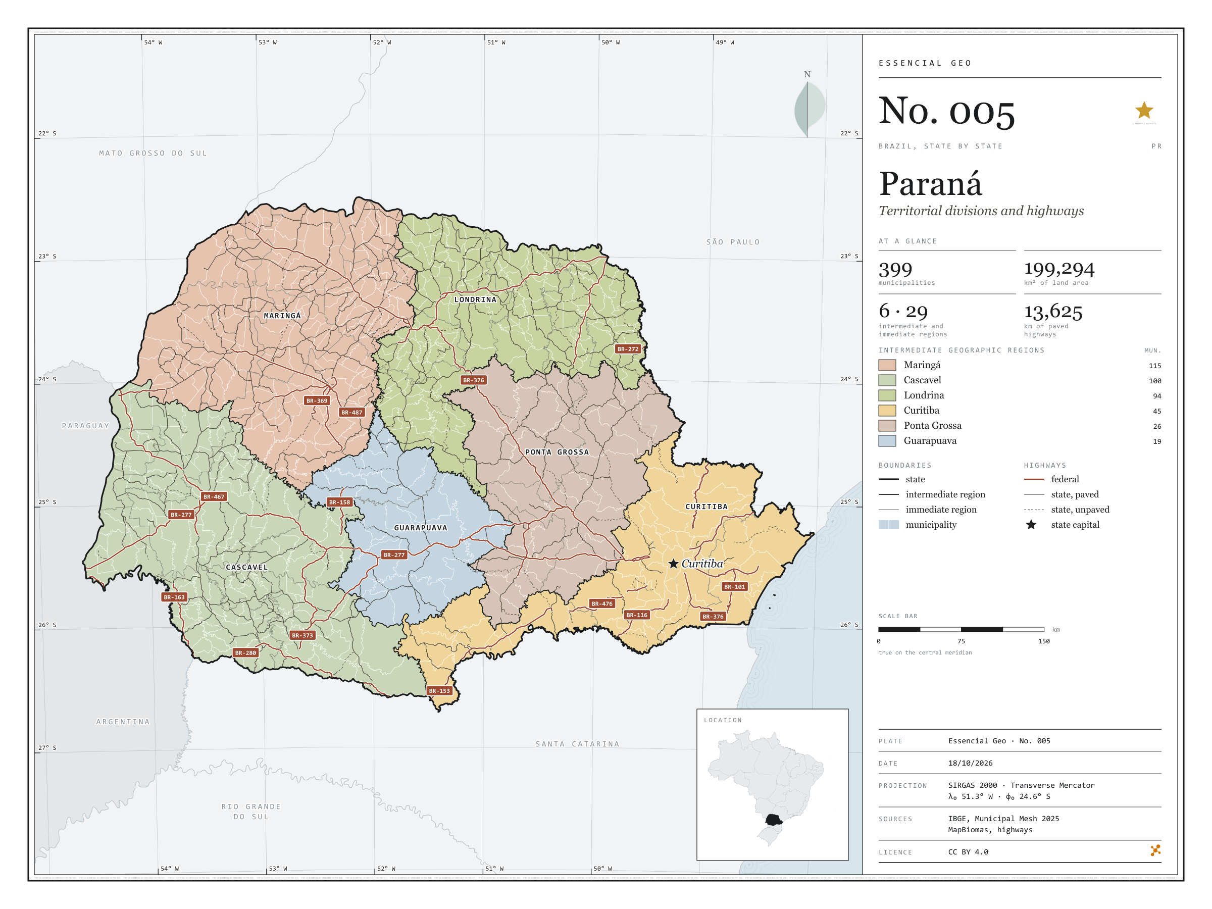
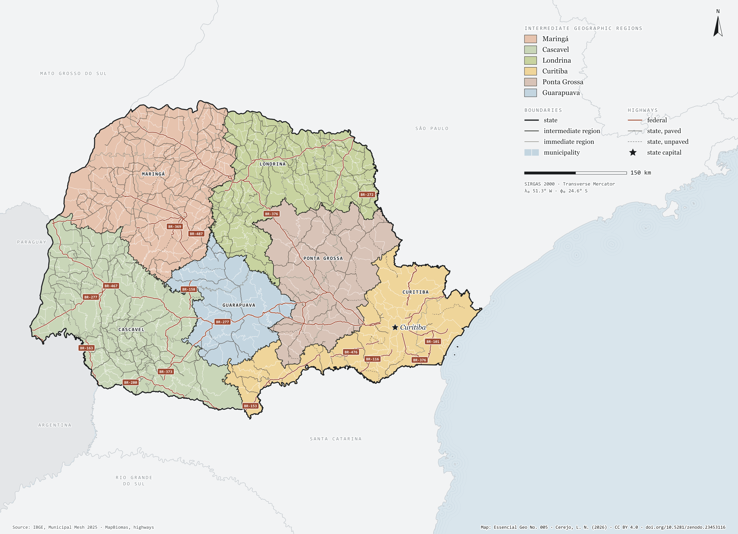
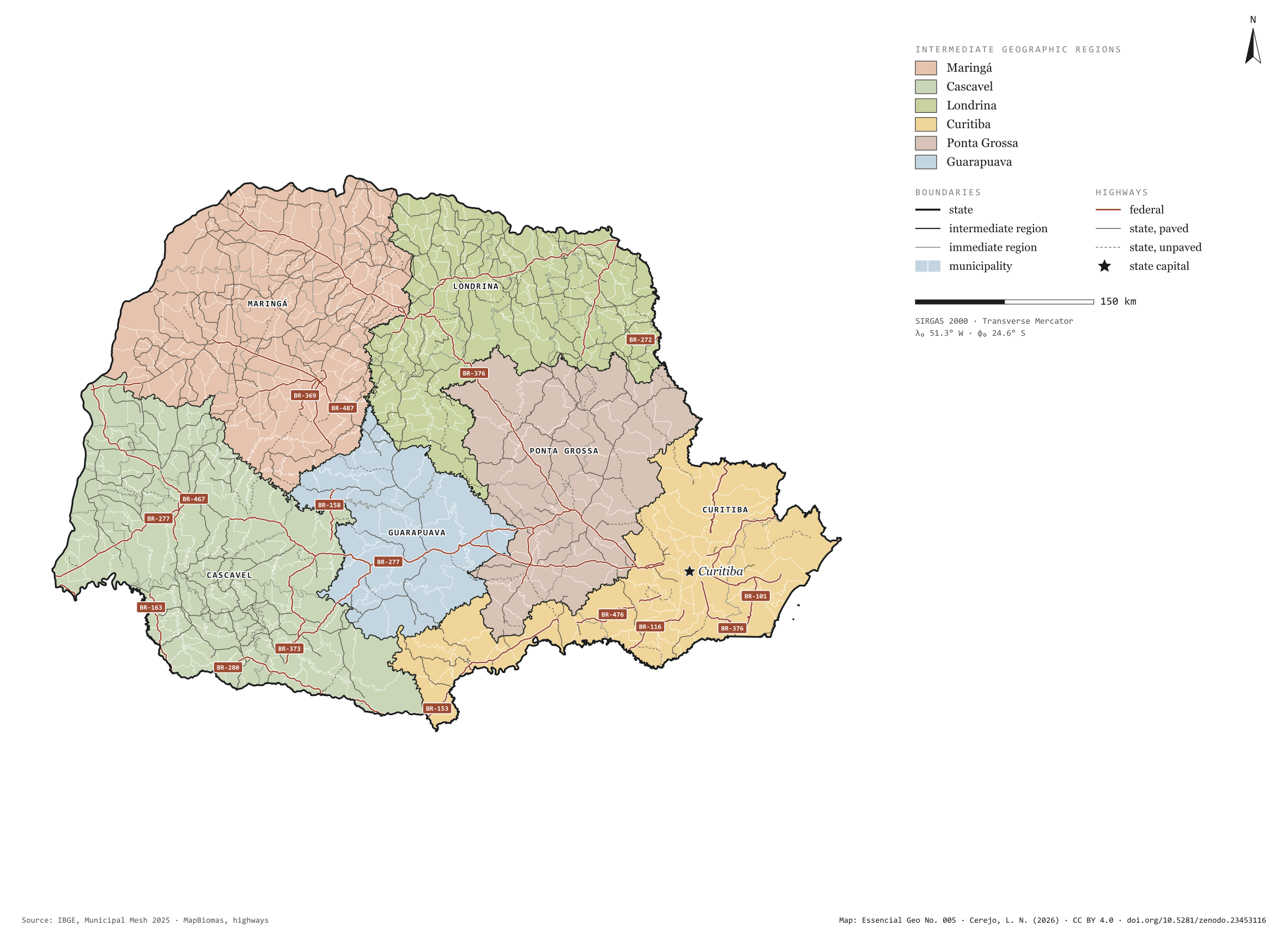
Fig. 005Paraná state (PR)EPSG:4674Source: IBGE, MapBiomas, Natural Earth
Paraná has 399 municipalities across 199,000 km², 2.3 per cent of Brazil. IBGE groups them into 29 immediate regions, drawn around the towns that supply jobs, trade and services to their surroundings, and into 6 intermediate regions that tie those networks together. Maringá is the intermediate region with the most municipalities (115); Guarapuava, the one with the fewest (19). The largest municipality is Guarapuava (3,164 km²); the smallest, Pinhais (61 km²). Part of the series “Brazil, state by state”: a clean base, with official boundaries and the road network, to start a map without losing the first afternoon gathering files.
Technical record · downloads · citation
At a glance
Municipalities per intermediate region (municipalities)
Maringá115
Cascavel100
Londrina94
Curitiba45
Ponta Grossa26
Guarapuava19
Area
199,294km²
Largest municipality: Guarapuava (3,164 km²); smallest: Pinhais (61 km²)
Paved highways
13,625km
3,513 km federal and 12,122 km state highways, paved or not
Layers
municipiospolygon399 municipalities, with IBGE code, regions, urban concentration and area (km²)
regioes_intermediariaspolygon6 intermediate geographic regions
regioes_imediataspolygon29 immediate geographic regions
limite_estadualpolygonBoundary of the federative unit
rodoviaslineFederal and state highways: route number, surface, physical status, carriageways
capitalpointIndicative point for the capital (not the exact seat)
The map without a frame, with legend, scale, reference system and credit written on it: ready for papers, lectures and slides. In two versions: with the basemap (neighbours and sea) or only the mapped area, on white.
CEREJO, Lucas Nakamura. Paraná: divisão territorial e rodovias. Versão 1.0.0. [S. l.]: Zenodo, 2026. Conjunto de dados. DOI: 10.5281/zenodo.23453116. Disponível em: https://doi.org/10.5281/zenodo.23453116. Acesso em: 10 nov. 2026.
Cerejo, L. N. (2026). Paraná: divisão territorial e rodovias [Paraná: Territorial divisions and highways] (Version 1.0.0) [Data set]. Zenodo. https://doi.org/10.5281/zenodo.23453116
@dataset{cerejo2026_estado_parana,
  author    = {Cerejo, Lucas Nakamura},
  title     = {Paraná: Divisão territorial e rodovias},
  year      = {2026},
  publisher = {Zenodo},
  version   = {1.0.0},
  doi       = {10.5281/zenodo.23453116},
  url       = {https://doi.org/10.5281/zenodo.23453116},
  language  = {portuguese},
  note      = {English title: Paraná: Territorial divisions and highways. Licence CC BY 4.0}
}