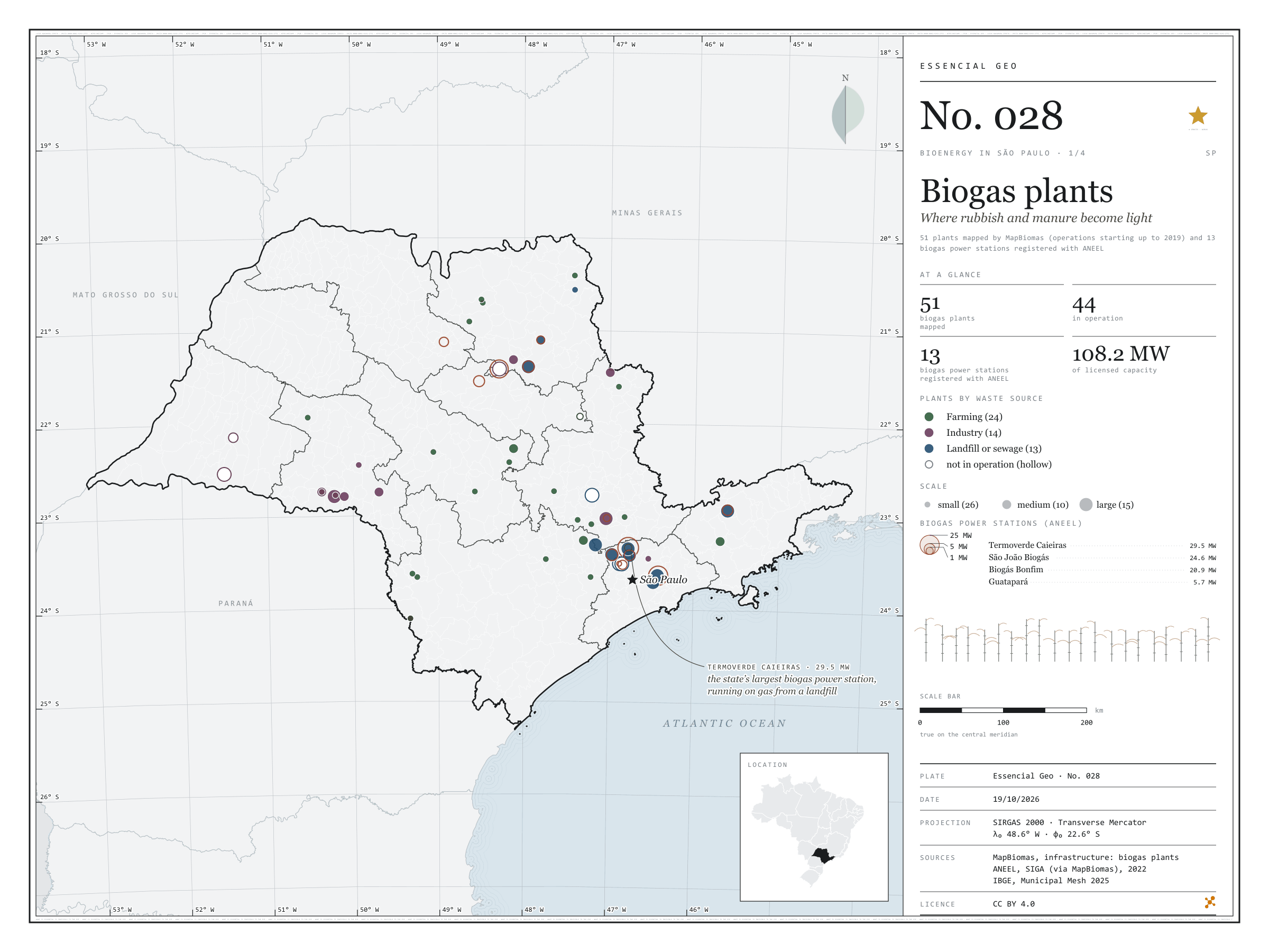
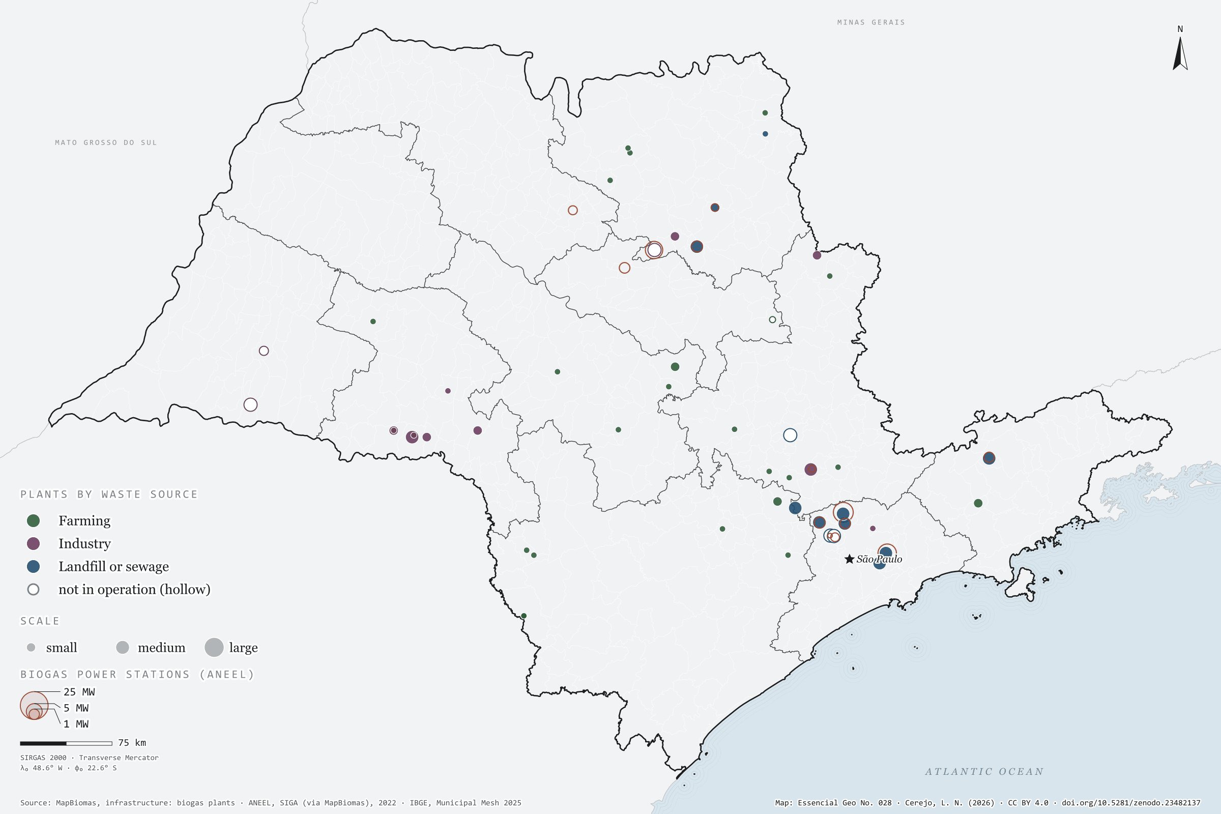
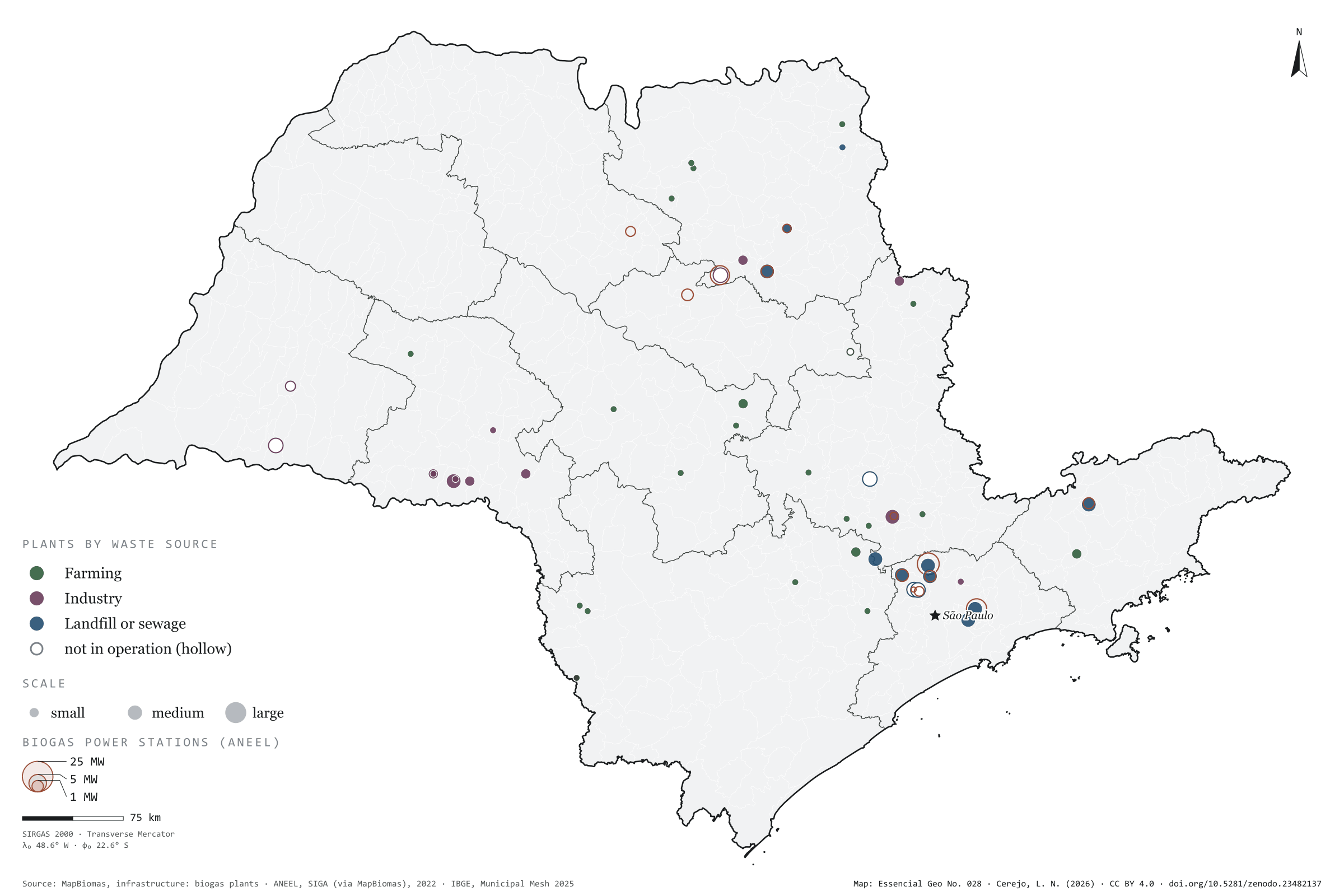
Fig. 028São Paulo state (SP)EPSG:4674Source: MapBiomas, ANEEL, IBGE
On top of a landfill in Caieiras, in Greater São Paulo, the gas rising from the rubbish drives the state’s largest biogas power station: 29.5 MW of licensed capacity. It is one of 13 biogas power stations registered with ANEEL in São Paulo, which together add up to 108.2 MW. MapBiomas maps other ways of using the same gas: 51 plants across the state, 44 of them in operation, burning manure from farms, industrial effluent and what comes out of landfills and sewage works to make electricity, heat or biomethane. On the map they gather around the capital and along the agro-industrial hubs of the interior. First plate of the collection “Bioenergy in São Paulo”, which follows waste all the way to energy.
Technical record · downloads · citation
At a glance
Biogas plants by waste source (plants)
Farming24
Industry14
Landfill or sewage13
Biogas power stations (ANEEL)
108MW
13 stations; the largest is Termoverde Caieiras (29.5 MW)
Layers
usinas_biogaspoint51 biogas plants: category, main use, status, scale and start of operations
ute_biogaspoint13 biogas power stations registered with ANEEL, with capacity (kW)
municipiospolygon645 municipalities, with the number of plants and biogas capacity
regioes_intermediariaspolygon11 intermediate geographic regions
The map without a frame, with legend, scale, reference system and credit written on it: ready for papers, lectures and slides. In two versions: with the basemap (neighbours and sea) or only the mapped area, on white.
CEREJO, Lucas Nakamura. Usinas de biogás: onde o lixo e o esterco viram luz. Versão 1.0.0. [S. l.]: Zenodo, 2026. Conjunto de dados. DOI: 10.5281/zenodo.23482137. Disponível em: https://doi.org/10.5281/zenodo.23482137. Acesso em: 10 nov. 2026.
Cerejo, L. N. (2026). Usinas de biogás: onde o lixo e o esterco viram luz [Biogas plants: Where rubbish and manure become light] (Version 1.0.0) [Data set]. Zenodo. https://doi.org/10.5281/zenodo.23482137
@dataset{cerejo2026_usinas_de_biogas_sp,
  author    = {Cerejo, Lucas Nakamura},
  title     = {Usinas de biogás: Onde o lixo e o esterco viram luz},
  year      = {2026},
  publisher = {Zenodo},
  version   = {1.0.0},
  doi       = {10.5281/zenodo.23482137},
  url       = {https://doi.org/10.5281/zenodo.23482137},
  language  = {portuguese},
  note      = {English title: Biogas plants: Where rubbish and manure become light. Licence CC BY 4.0}
}
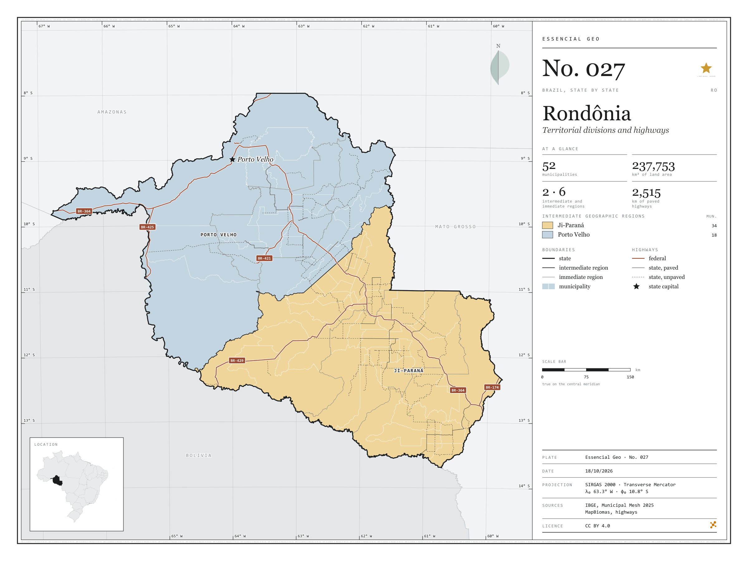
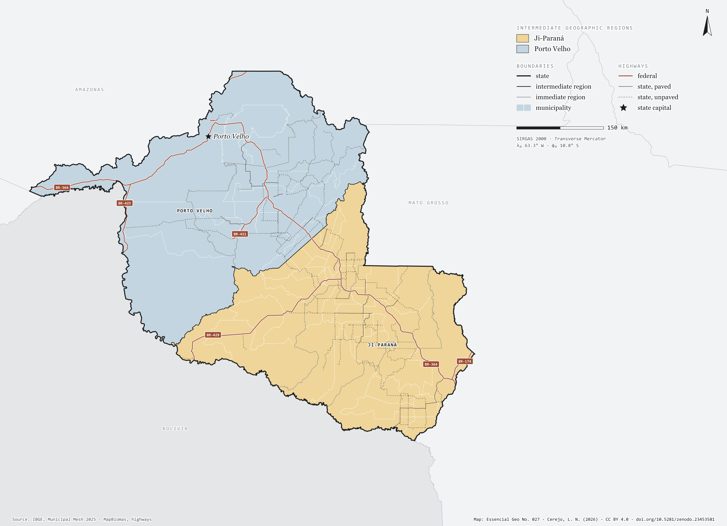
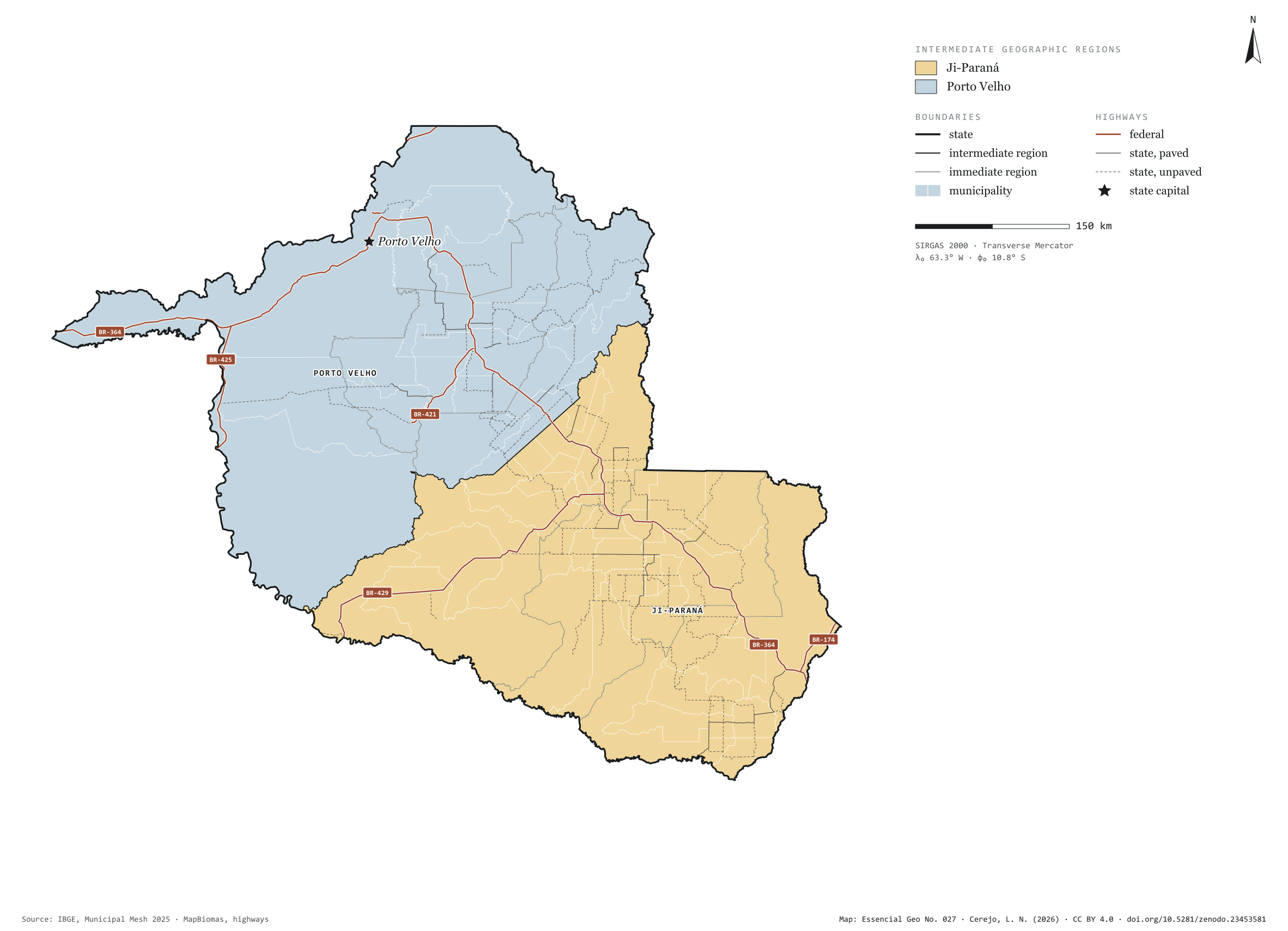
Fig. 027Rondônia state (RO)EPSG:4674Source: IBGE, MapBiomas, Natural Earth
Rondônia has 52 municipalities across 238,000 km², 2.8 per cent of Brazil. IBGE groups them into 6 immediate regions, drawn around the towns that supply jobs, trade and services to their surroundings, and into 2 intermediate regions that tie those networks together. Ji-Paraná is the intermediate region with the most municipalities (34); Porto Velho, the one with the fewest (18). The largest municipality is Porto Velho (34,091 km²); the smallest, Teixeirópolis (460 km²). Part of the series “Brazil, state by state”: a clean base, with official boundaries and the road network, to start a map without losing the first afternoon gathering files.
Technical record · downloads · citation
At a glance
Municipalities per intermediate region (municipalities)
Ji-Paraná34
Porto Velho18
Area
237,753km²
Largest municipality: Porto Velho (34,091 km²); smallest: Teixeirópolis (460 km²)
Paved highways
2,515km
1,775 km federal and 4,507 km state highways, paved or not
Layers
municipiospolygon52 municipalities, with IBGE code, regions, urban concentration and area (km²)
regioes_intermediariaspolygon2 intermediate geographic regions
regioes_imediataspolygon6 immediate geographic regions
limite_estadualpolygonBoundary of the federative unit
rodoviaslineFederal and state highways: route number, surface, physical status, carriageways
capitalpointIndicative point for the capital (not the exact seat)
The map without a frame, with legend, scale, reference system and credit written on it: ready for papers, lectures and slides. In two versions: with the basemap (neighbours and sea) or only the mapped area, on white.
CEREJO, Lucas Nakamura. Rondônia: divisão territorial e rodovias. Versão 1.0.0. [S. l.]: Zenodo, 2026. Conjunto de dados. DOI: 10.5281/zenodo.23453581. Disponível em: https://doi.org/10.5281/zenodo.23453581. Acesso em: 10 nov. 2026.
Cerejo, L. N. (2026). Rondônia: divisão territorial e rodovias [Rondônia: Territorial divisions and highways] (Version 1.0.0) [Data set]. Zenodo. https://doi.org/10.5281/zenodo.23453581
@dataset{cerejo2026_estado_rondonia,
  author    = {Cerejo, Lucas Nakamura},
  title     = {Rondônia: Divisão territorial e rodovias},
  year      = {2026},
  publisher = {Zenodo},
  version   = {1.0.0},
  doi       = {10.5281/zenodo.23453581},
  url       = {https://doi.org/10.5281/zenodo.23453581},
  language  = {portuguese},
  note      = {English title: Rondônia: Territorial divisions and highways. Licence CC BY 4.0}
}
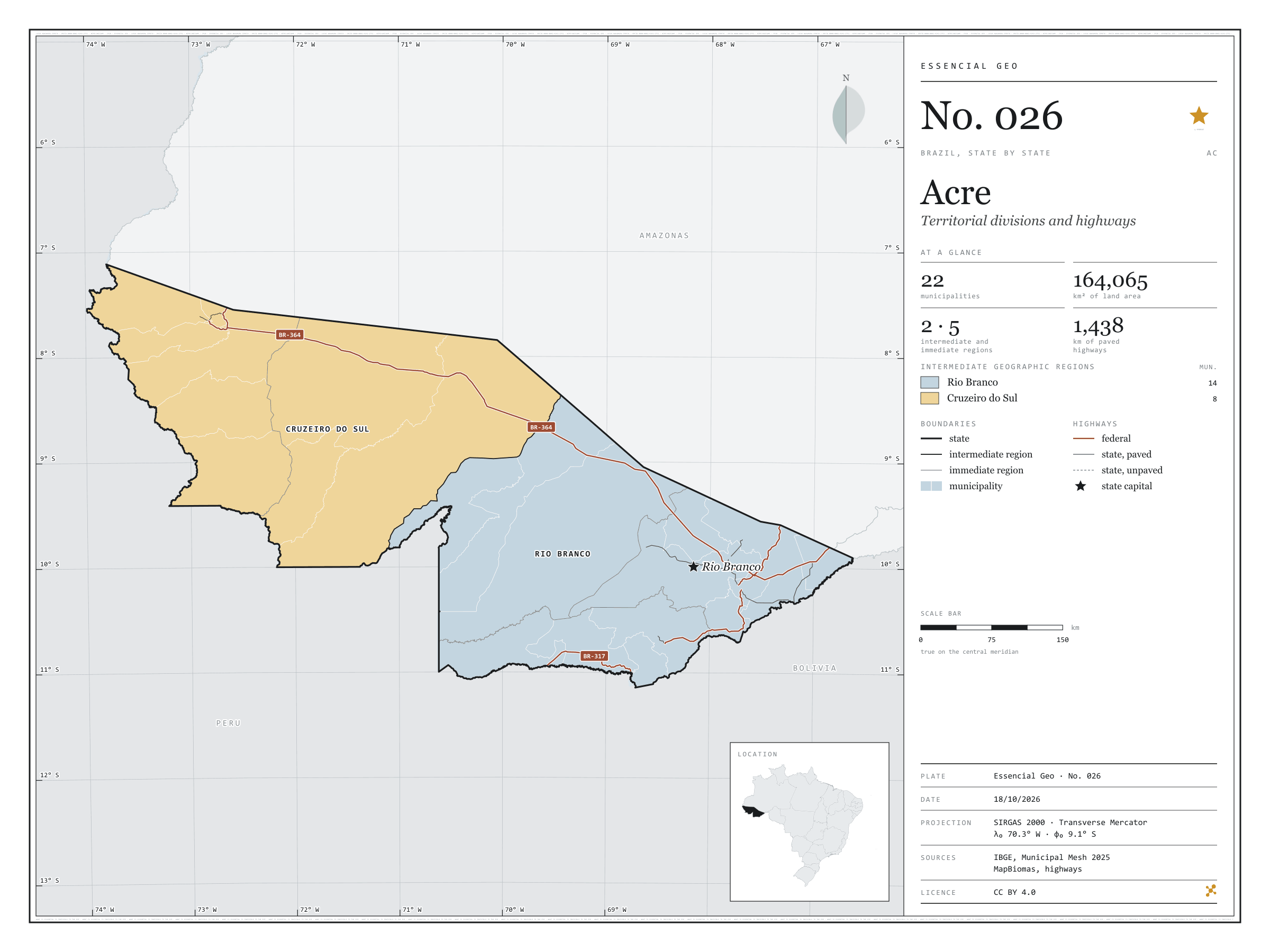
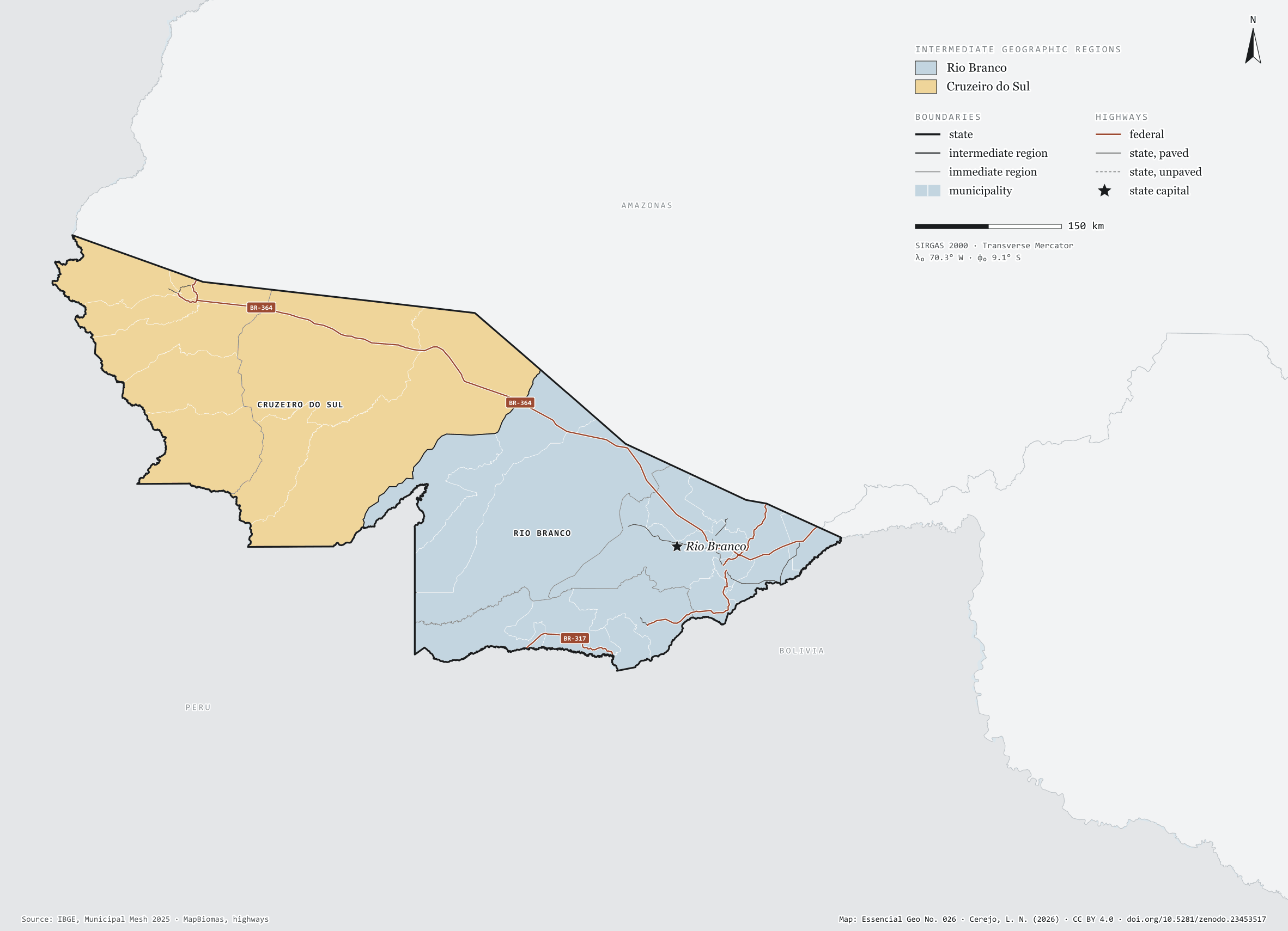
Fig. 026Acre state (AC)EPSG:4674Source: IBGE, MapBiomas, Natural Earth
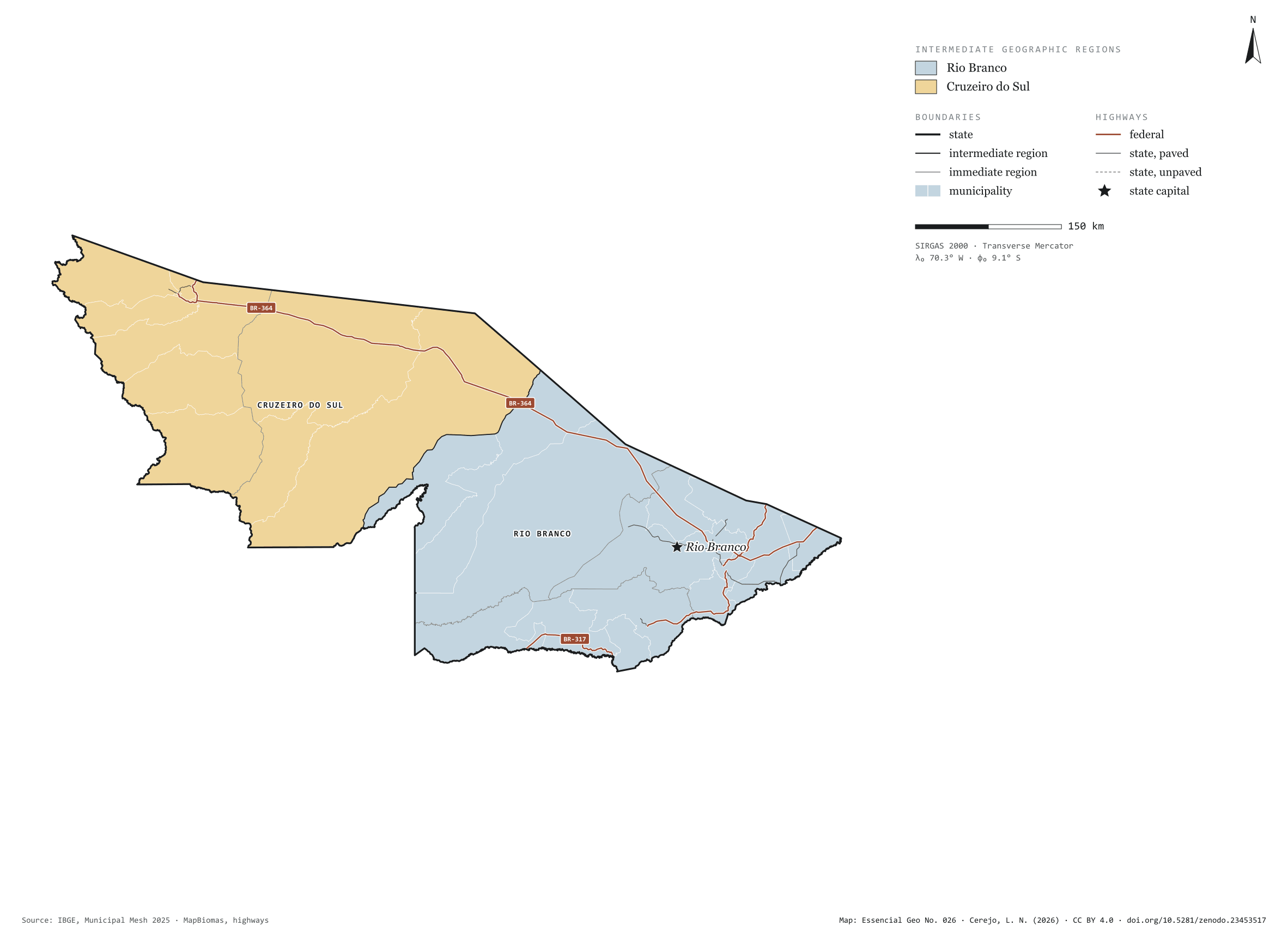
Acre has 22 municipalities across 164,000 km², 1.9 per cent of Brazil. IBGE groups them into 5 immediate regions, drawn around the towns that supply jobs, trade and services to their surroundings, and into 2 intermediate regions that tie those networks together. Rio Branco is the intermediate region with the most municipalities (14); Cruzeiro do Sul, the one with the fewest (8). The largest municipality is Feijó (27,947 km²); the smallest, Epitaciolândia (1,653 km²). Part of the series “Brazil, state by state”: a clean base, with official boundaries and the road network, to start a map without losing the first afternoon gathering files.
Technical record · downloads · citation
At a glance
Municipalities per intermediate region (municipalities)
Rio Branco14
Cruzeiro do Sul8
Area
164,065km²
Largest municipality: Feijó (27,947 km²); smallest: Epitaciolândia (1,653 km²)
Paved highways
1,438km
1,135 km federal and 303 km state highways, paved or not
Layers
municipiospolygon22 municipalities, with IBGE code, regions, urban concentration and area (km²)
regioes_intermediariaspolygon2 intermediate geographic regions
regioes_imediataspolygon5 immediate geographic regions
limite_estadualpolygonBoundary of the federative unit
rodoviaslineFederal and state highways: route number, surface, physical status, carriageways
capitalpointIndicative point for the capital (not the exact seat)
The map without a frame, with legend, scale, reference system and credit written on it: ready for papers, lectures and slides. In two versions: with the basemap (neighbours and sea) or only the mapped area, on white.
CEREJO, Lucas Nakamura. Acre: divisão territorial e rodovias. Versão 1.0.0. [S. l.]: Zenodo, 2026. Conjunto de dados. DOI: 10.5281/zenodo.23453517. Disponível em: https://doi.org/10.5281/zenodo.23453517. Acesso em: 10 nov. 2026.
Cerejo, L. N. (2026). Acre: divisão territorial e rodovias [Acre: Territorial divisions and highways] (Version 1.0.0) [Data set]. Zenodo. https://doi.org/10.5281/zenodo.23453517
@dataset{cerejo2026_estado_acre,
  author    = {Cerejo, Lucas Nakamura},
  title     = {Acre: Divisão territorial e rodovias},
  year      = {2026},
  publisher = {Zenodo},
  version   = {1.0.0},
  doi       = {10.5281/zenodo.23453517},
  url       = {https://doi.org/10.5281/zenodo.23453517},
  language  = {portuguese},
  note      = {English title: Acre: Territorial divisions and highways. Licence CC BY 4.0}
}
Fig. 025Roraima state (RR)EPSG:4674Source: IBGE, MapBiomas, Natural Earth
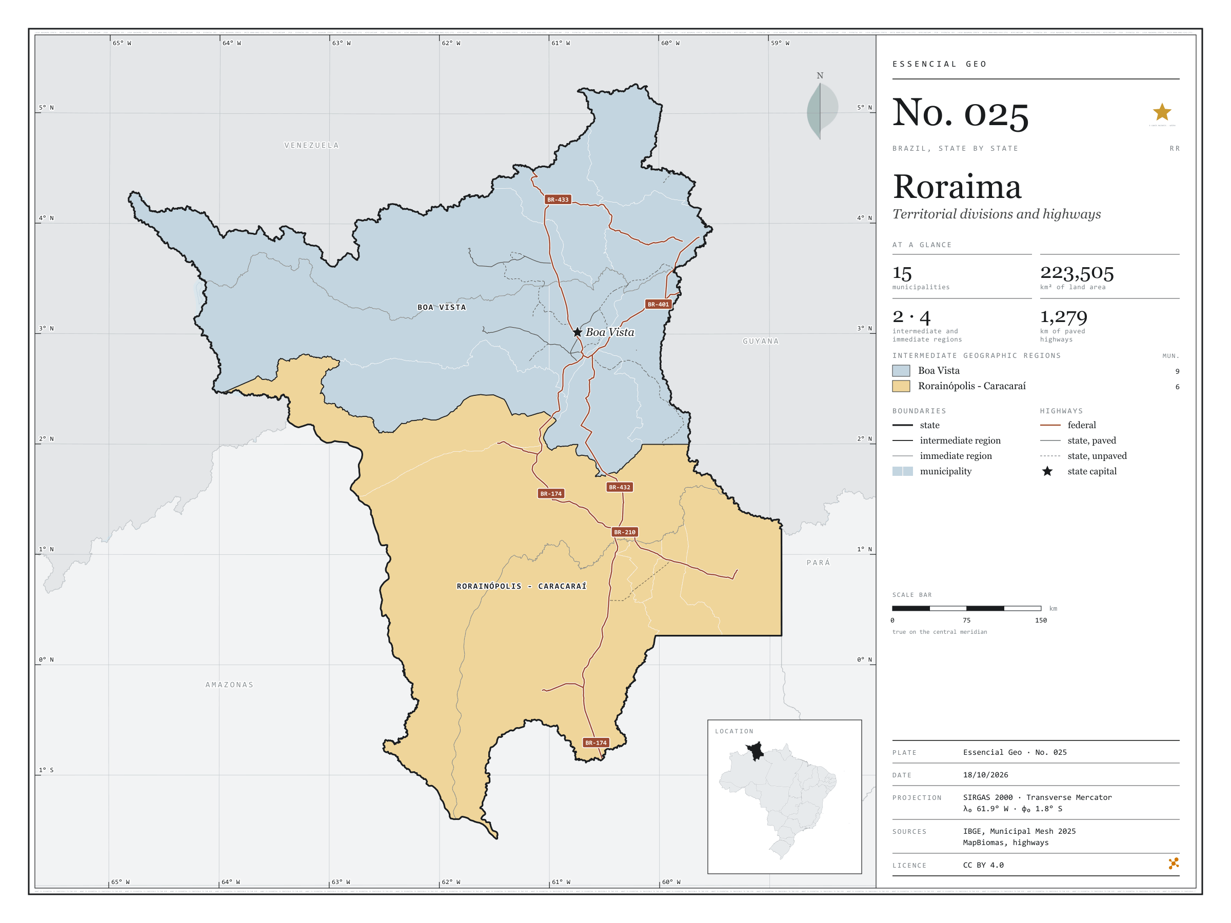
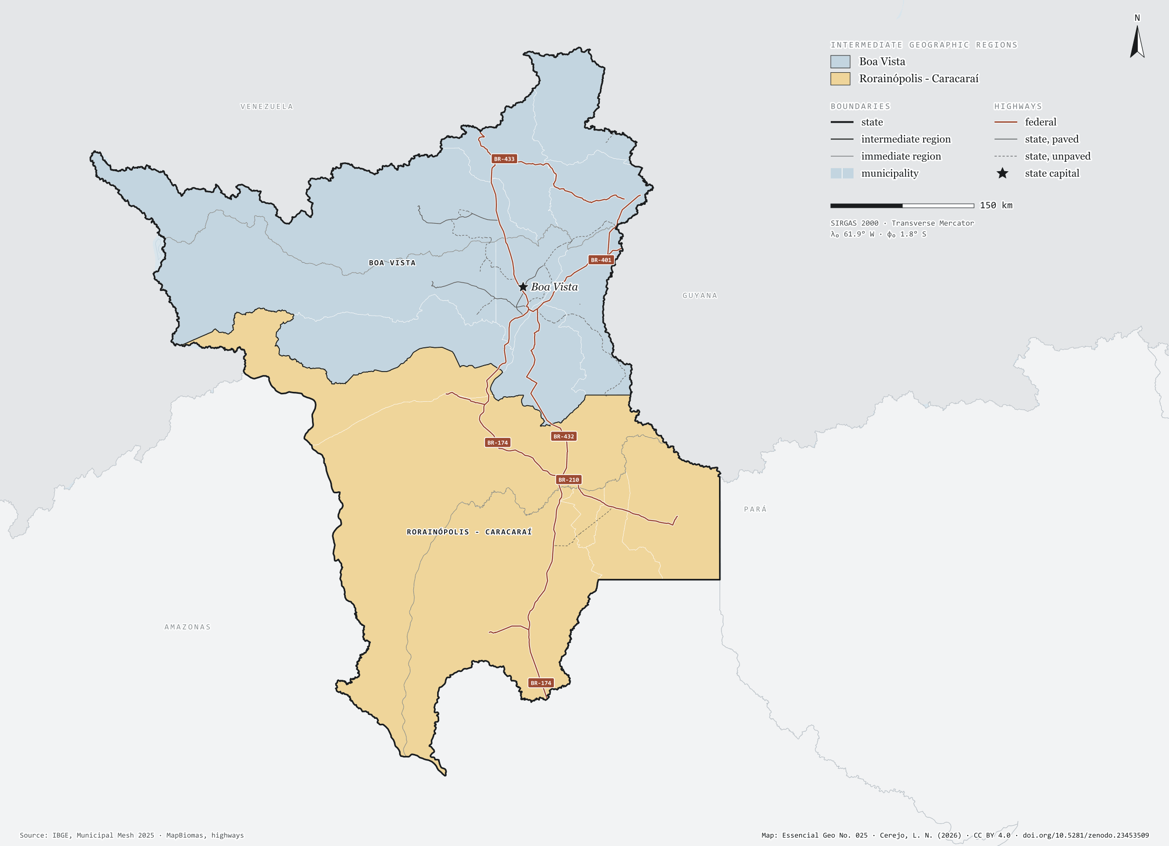
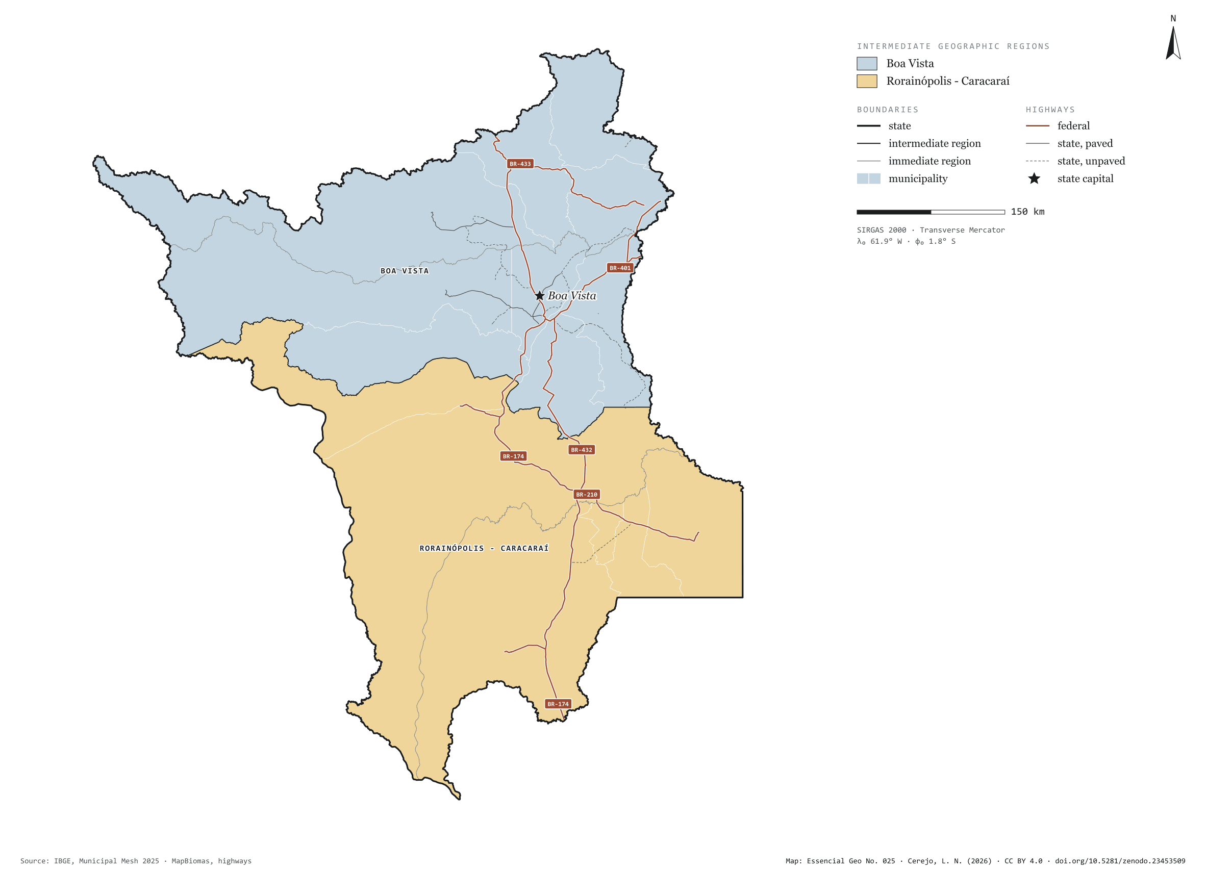
Roraima has 15 municipalities across 224,000 km², 2.6 per cent of Brazil. IBGE groups them into 4 immediate regions, drawn around the towns that supply jobs, trade and services to their surroundings, and into 2 intermediate regions that tie those networks together. Boa Vista is the intermediate region with the most municipalities (9); Rorainópolis - Caracaraí, the one with the fewest (6). The largest municipality is Caracaraí (47,385 km²); the smallest, São Luiz do Anauá (1,527 km²). Part of the series “Brazil, state by state”: a clean base, with official boundaries and the road network, to start a map without losing the first afternoon gathering files.
Technical record · downloads · citation
At a glance
Municipalities per intermediate region (municipalities)
Boa Vista9
Rorainópolis - Caracaraí6
Area
223,505km²
Largest municipality: Caracaraí (47,385 km²); smallest: São Luiz do Anauá (1,527 km²)
Paved highways
1,279km
1,528 km federal and 922 km state highways, paved or not
Layers
municipiospolygon15 municipalities, with IBGE code, regions, urban concentration and area (km²)
regioes_intermediariaspolygon2 intermediate geographic regions
regioes_imediataspolygon4 immediate geographic regions
limite_estadualpolygonBoundary of the federative unit
rodoviaslineFederal and state highways: route number, surface, physical status, carriageways
capitalpointIndicative point for the capital (not the exact seat)
The map without a frame, with legend, scale, reference system and credit written on it: ready for papers, lectures and slides. In two versions: with the basemap (neighbours and sea) or only the mapped area, on white.
CEREJO, Lucas Nakamura. Roraima: divisão territorial e rodovias. Versão 1.0.0. [S. l.]: Zenodo, 2026. Conjunto de dados. DOI: 10.5281/zenodo.23453509. Disponível em: https://doi.org/10.5281/zenodo.23453509. Acesso em: 10 nov. 2026.
Cerejo, L. N. (2026). Roraima: divisão territorial e rodovias [Roraima: Territorial divisions and highways] (Version 1.0.0) [Data set]. Zenodo. https://doi.org/10.5281/zenodo.23453509
@dataset{cerejo2026_estado_roraima,
  author    = {Cerejo, Lucas Nakamura},
  title     = {Roraima: Divisão territorial e rodovias},
  year      = {2026},
  publisher = {Zenodo},
  version   = {1.0.0},
  doi       = {10.5281/zenodo.23453509},
  url       = {https://doi.org/10.5281/zenodo.23453509},
  language  = {portuguese},
  note      = {English title: Roraima: Territorial divisions and highways. Licence CC BY 4.0}
}
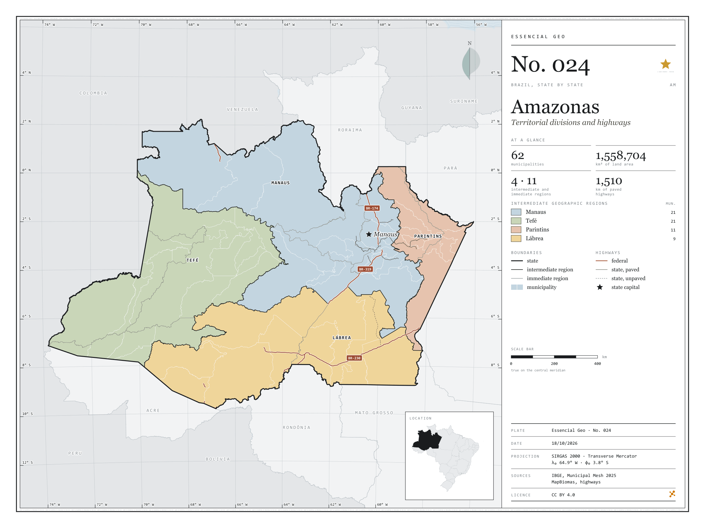
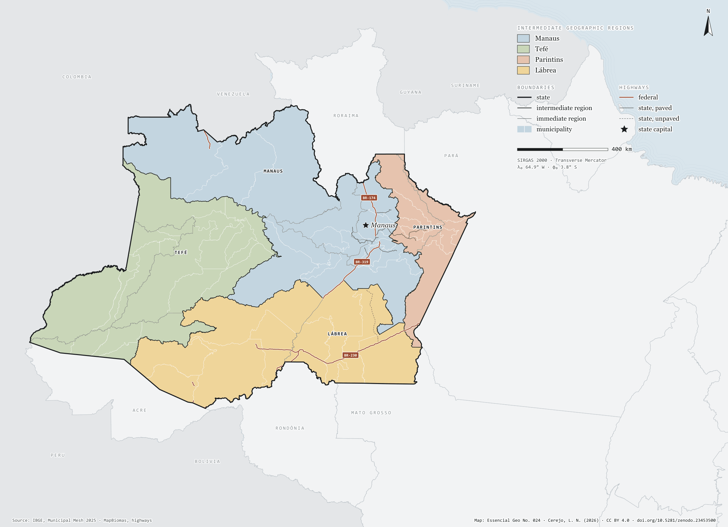
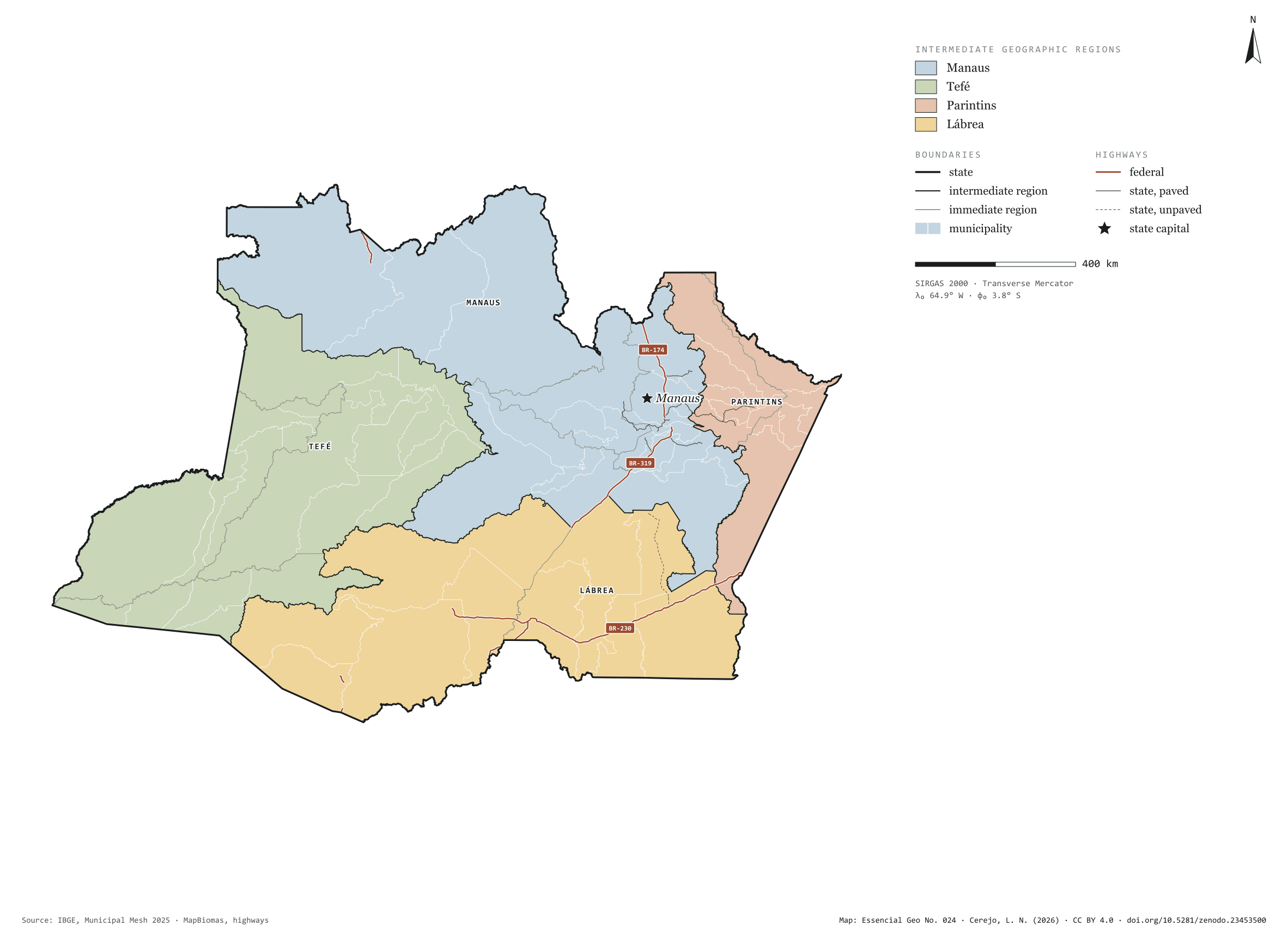
Fig. 024Amazonas state (AM)EPSG:4674Source: IBGE, MapBiomas, Natural Earth
Amazonas has 62 municipalities across 1,559,000 km², 18.3 per cent of Brazil. IBGE groups them into 11 immediate regions, drawn around the towns that supply jobs, trade and services to their surroundings, and into 4 intermediate regions that tie those networks together. Manaus is the intermediate region with the most municipalities (21); Lábrea, the one with the fewest (9). The largest municipality is Barcelos (122,454 km²); the smallest, Iranduba (2,332 km²). Part of the series “Brazil, state by state”: a clean base, with official boundaries and the road network, to start a map without losing the first afternoon gathering files.
Technical record · downloads · citation
At a glance
Municipalities per intermediate region (municipalities)
Manaus21
Tefé21
Parintins11
Lábrea9
Area
1,558,704km²
Largest municipality: Barcelos (122,454 km²); smallest: Iranduba (2,332 km²)
Paved highways
1,510km
1,694 km federal and 1,092 km state highways, paved or not
Layers
municipiospolygon62 municipalities, with IBGE code, regions, urban concentration and area (km²)
regioes_intermediariaspolygon4 intermediate geographic regions
regioes_imediataspolygon11 immediate geographic regions
limite_estadualpolygonBoundary of the federative unit
rodoviaslineFederal and state highways: route number, surface, physical status, carriageways
capitalpointIndicative point for the capital (not the exact seat)
The map without a frame, with legend, scale, reference system and credit written on it: ready for papers, lectures and slides. In two versions: with the basemap (neighbours and sea) or only the mapped area, on white.
CEREJO, Lucas Nakamura. Amazonas: divisão territorial e rodovias. Versão 1.0.0. [S. l.]: Zenodo, 2026. Conjunto de dados. DOI: 10.5281/zenodo.23453500. Disponível em: https://doi.org/10.5281/zenodo.23453500. Acesso em: 10 nov. 2026.
Cerejo, L. N. (2026). Amazonas: divisão territorial e rodovias [Amazonas: Territorial divisions and highways] (Version 1.0.0) [Data set]. Zenodo. https://doi.org/10.5281/zenodo.23453500
@dataset{cerejo2026_estado_amazonas,
  author    = {Cerejo, Lucas Nakamura},
  title     = {Amazonas: Divisão territorial e rodovias},
  year      = {2026},
  publisher = {Zenodo},
  version   = {1.0.0},
  doi       = {10.5281/zenodo.23453500},
  url       = {https://doi.org/10.5281/zenodo.23453500},
  language  = {portuguese},
  note      = {English title: Amazonas: Territorial divisions and highways. Licence CC BY 4.0}
}
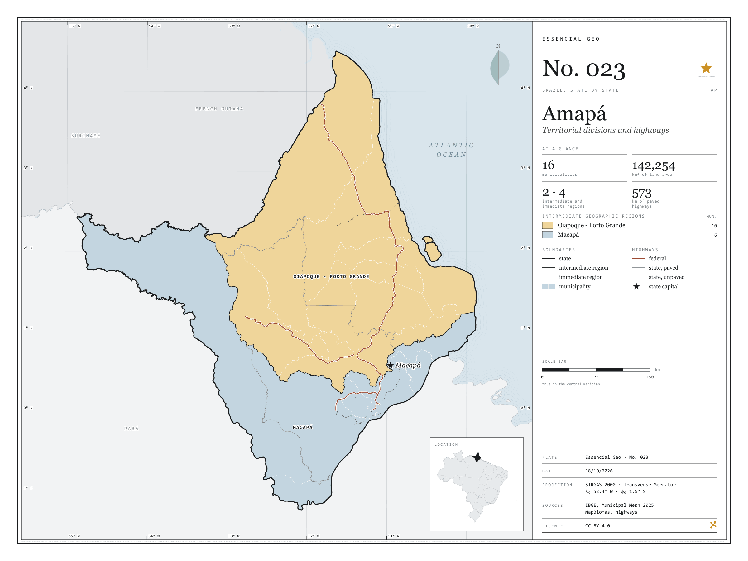
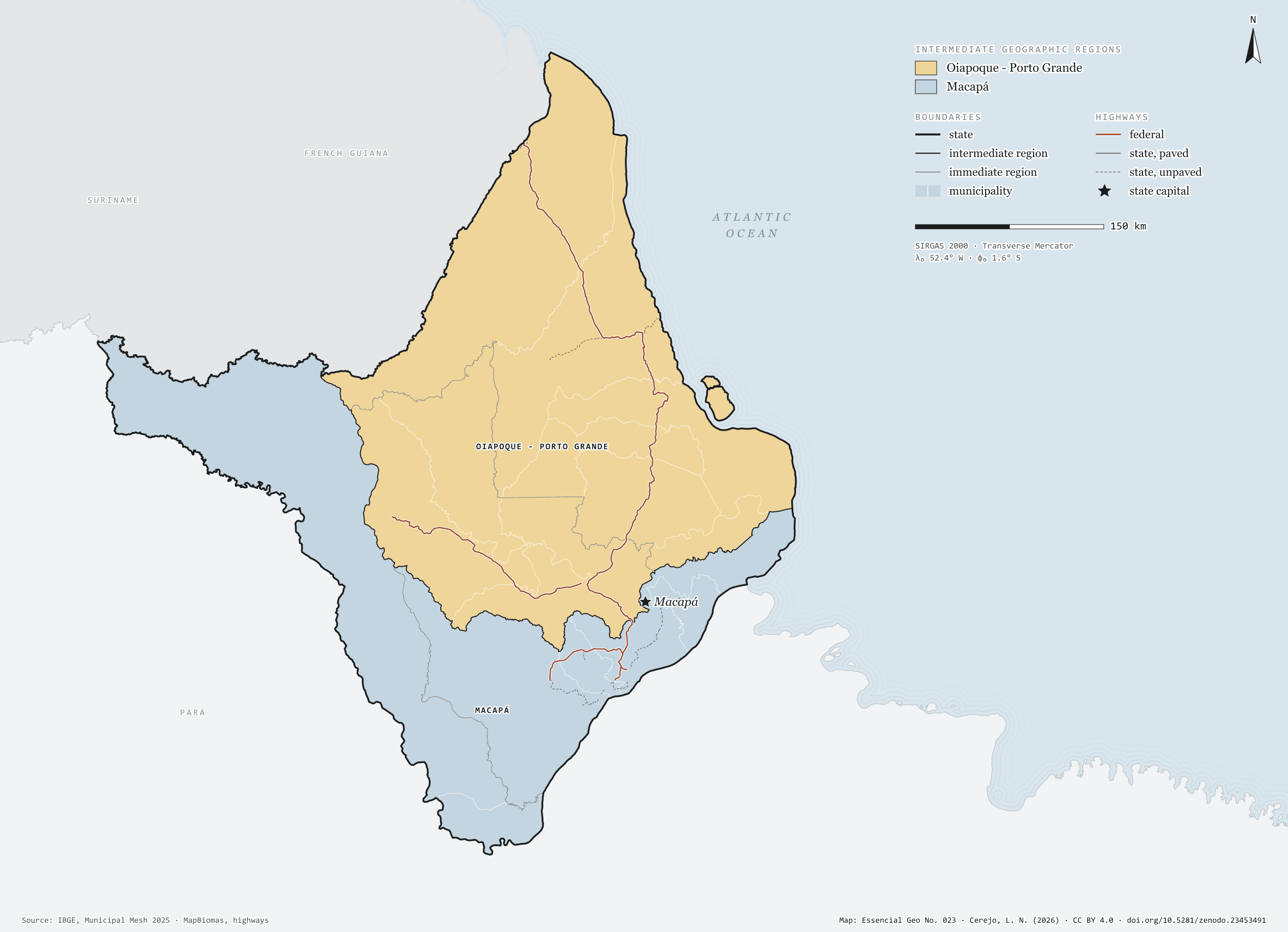
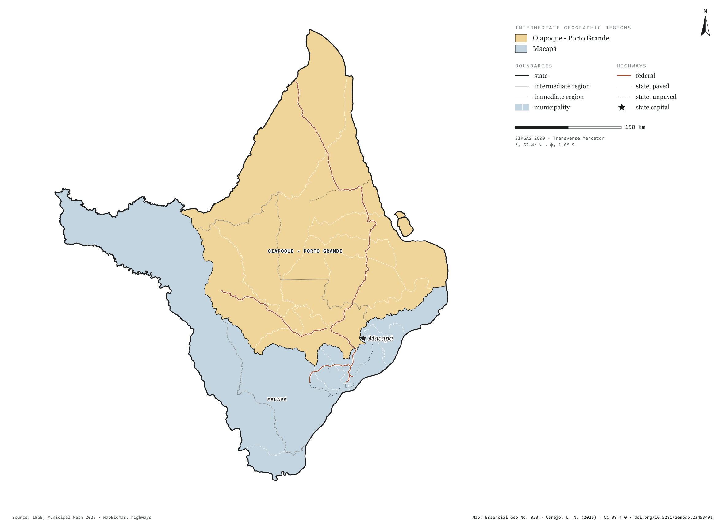
Fig. 023Amapá state (AP)EPSG:4674Source: IBGE, MapBiomas, Natural Earth
Amapá has 16 municipalities across 142,000 km², 1.7 per cent of Brazil. IBGE groups them into 4 immediate regions, drawn around the towns that supply jobs, trade and services to their surroundings, and into 2 intermediate regions that tie those networks together. Oiapoque - Porto Grande is the intermediate region with the most municipalities (10); Macapá, the one with the fewest (6). The largest municipality is Laranjal do Jari (30,542 km²); the smallest, Santana (1,541 km²). Part of the series “Brazil, state by state”: a clean base, with official boundaries and the road network, to start a map without losing the first afternoon gathering files.
Technical record · downloads · citation
At a glance
Municipalities per intermediate region (municipalities)
Oiapoque - Porto Grande10
Macapá6
Area
142,254km²
Largest municipality: Laranjal do Jari (30,542 km²); smallest: Santana (1,541 km²)
Paved highways
573km
863 km federal and 310 km state highways, paved or not
Layers
municipiospolygon16 municipalities, with IBGE code, regions, urban concentration and area (km²)
regioes_intermediariaspolygon2 intermediate geographic regions
regioes_imediataspolygon4 immediate geographic regions
limite_estadualpolygonBoundary of the federative unit
rodoviaslineFederal and state highways: route number, surface, physical status, carriageways
capitalpointIndicative point for the capital (not the exact seat)
The map without a frame, with legend, scale, reference system and credit written on it: ready for papers, lectures and slides. In two versions: with the basemap (neighbours and sea) or only the mapped area, on white.
CEREJO, Lucas Nakamura. Amapá: divisão territorial e rodovias. Versão 1.0.0. [S. l.]: Zenodo, 2026. Conjunto de dados. DOI: 10.5281/zenodo.23453491. Disponível em: https://doi.org/10.5281/zenodo.23453491. Acesso em: 10 nov. 2026.
Cerejo, L. N. (2026). Amapá: divisão territorial e rodovias [Amapá: Territorial divisions and highways] (Version 1.0.0) [Data set]. Zenodo. https://doi.org/10.5281/zenodo.23453491
@dataset{cerejo2026_estado_amapa,
  author    = {Cerejo, Lucas Nakamura},
  title     = {Amapá: Divisão territorial e rodovias},
  year      = {2026},
  publisher = {Zenodo},
  version   = {1.0.0},
  doi       = {10.5281/zenodo.23453491},
  url       = {https://doi.org/10.5281/zenodo.23453491},
  language  = {portuguese},
  note      = {English title: Amapá: Territorial divisions and highways. Licence CC BY 4.0}
}
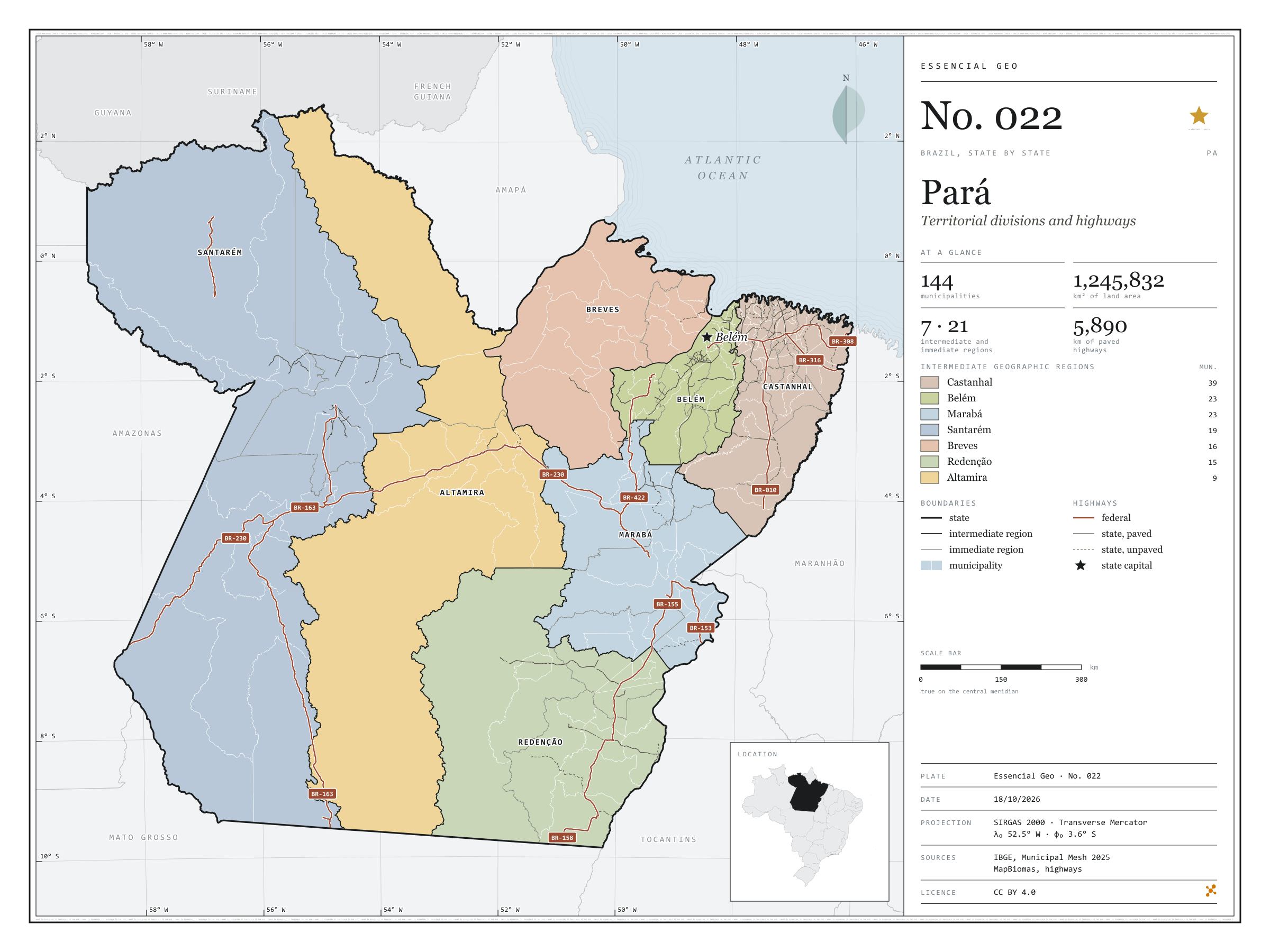
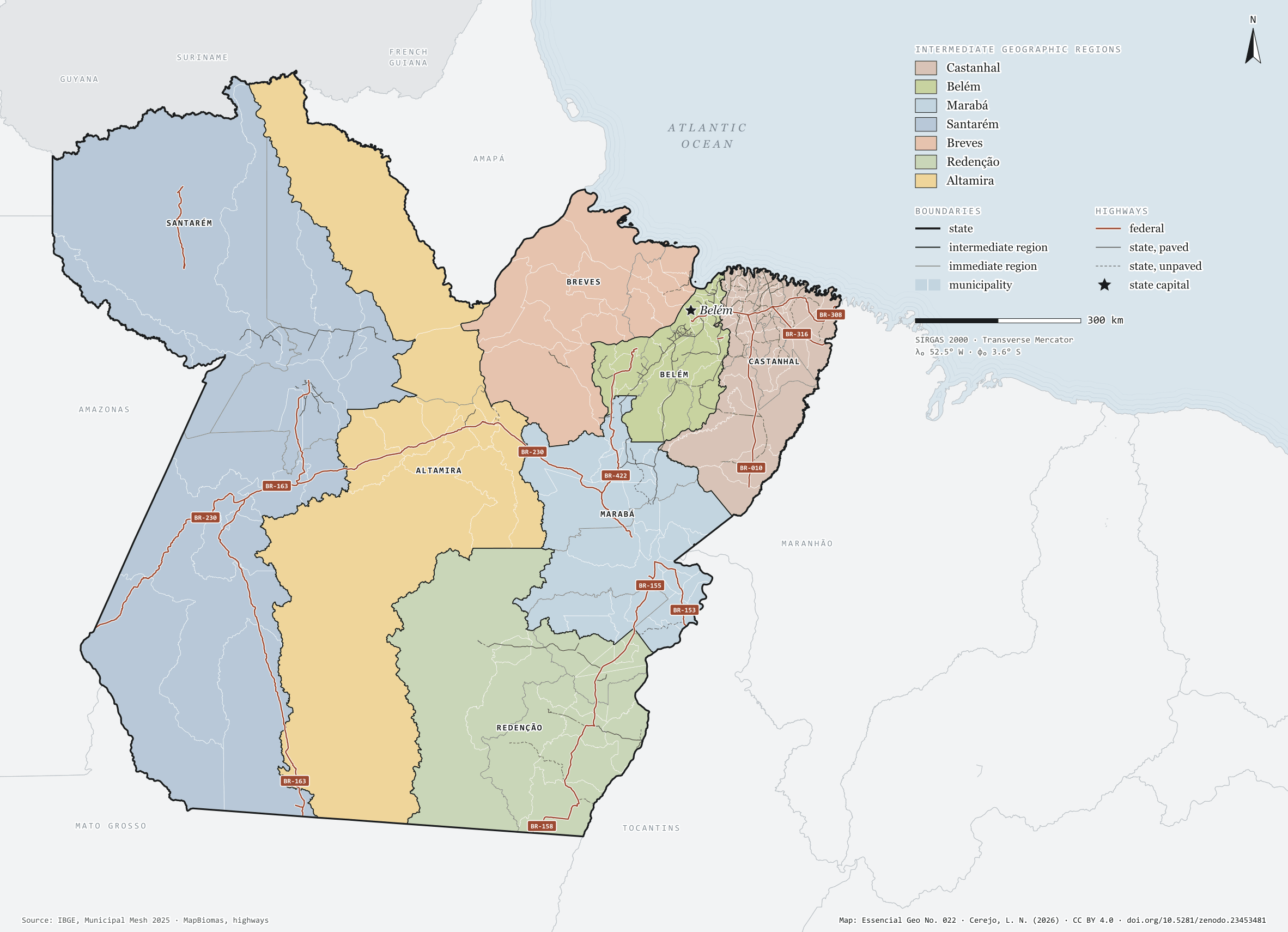
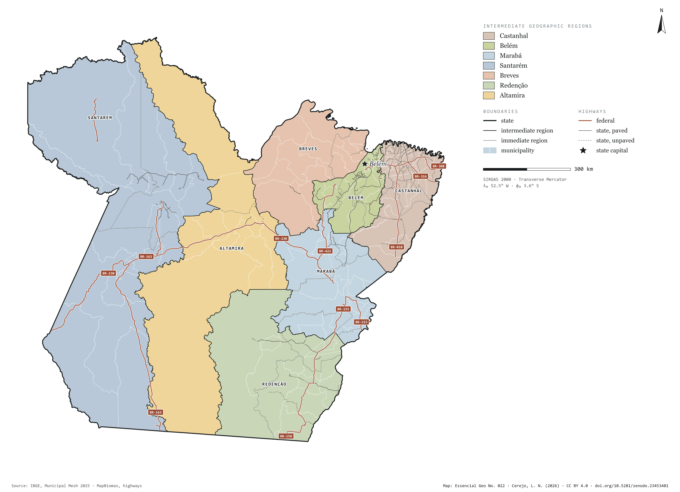
Fig. 022Pará state (PA)EPSG:4674Source: IBGE, MapBiomas, Natural Earth
Pará has 144 municipalities across 1,246,000 km², 14.6 per cent of Brazil. IBGE groups them into 21 immediate regions, drawn around the towns that supply jobs, trade and services to their surroundings, and into 7 intermediate regions that tie those networks together. Castanhal is the intermediate region with the most municipalities (39); Altamira, the one with the fewest (9). The largest municipality is Altamira (159,533 km²); the smallest, Marituba (103 km²). Part of the series “Brazil, state by state”: a clean base, with official boundaries and the road network, to start a map without losing the first afternoon gathering files.
Technical record · downloads · citation
At a glance
Municipalities per intermediate region (municipalities)
Castanhal39
Belém23
Marabá23
Santarém19
Breves16
Redenção15
Altamira9
Area
1,245,832km²
Largest municipality: Altamira (159,533 km²); smallest: Marituba (103 km²)
Paved highways
5,890km
4,361 km federal and 5,202 km state highways, paved or not
Layers
municipiospolygon144 municipalities, with IBGE code, regions, urban concentration and area (km²)
regioes_intermediariaspolygon7 intermediate geographic regions
regioes_imediataspolygon21 immediate geographic regions
limite_estadualpolygonBoundary of the federative unit
rodoviaslineFederal and state highways: route number, surface, physical status, carriageways
capitalpointIndicative point for the capital (not the exact seat)
The map without a frame, with legend, scale, reference system and credit written on it: ready for papers, lectures and slides. In two versions: with the basemap (neighbours and sea) or only the mapped area, on white.
CEREJO, Lucas Nakamura. Pará: divisão territorial e rodovias. Versão 1.0.0. [S. l.]: Zenodo, 2026. Conjunto de dados. DOI: 10.5281/zenodo.23453481. Disponível em: https://doi.org/10.5281/zenodo.23453481. Acesso em: 10 nov. 2026.
Cerejo, L. N. (2026). Pará: divisão territorial e rodovias [Pará: Territorial divisions and highways] (Version 1.0.0) [Data set]. Zenodo. https://doi.org/10.5281/zenodo.23453481
@dataset{cerejo2026_estado_para,
  author    = {Cerejo, Lucas Nakamura},
  title     = {Pará: Divisão territorial e rodovias},
  year      = {2026},
  publisher = {Zenodo},
  version   = {1.0.0},
  doi       = {10.5281/zenodo.23453481},
  url       = {https://doi.org/10.5281/zenodo.23453481},
  language  = {portuguese},
  note      = {English title: Pará: Territorial divisions and highways. Licence CC BY 4.0}
}
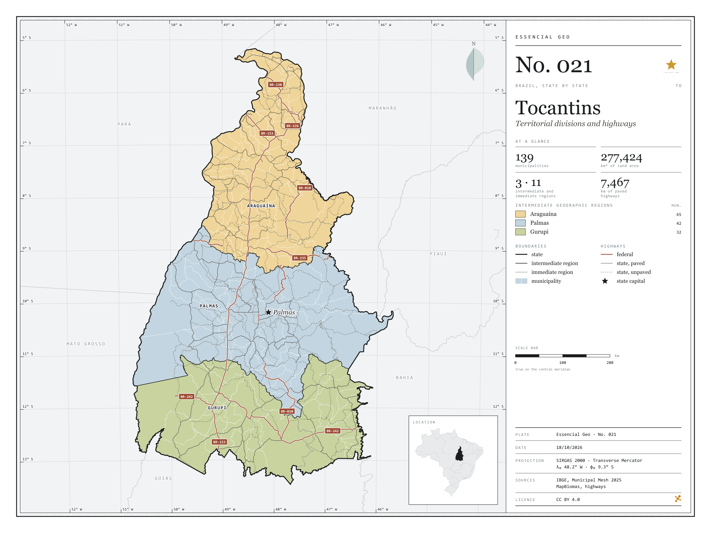
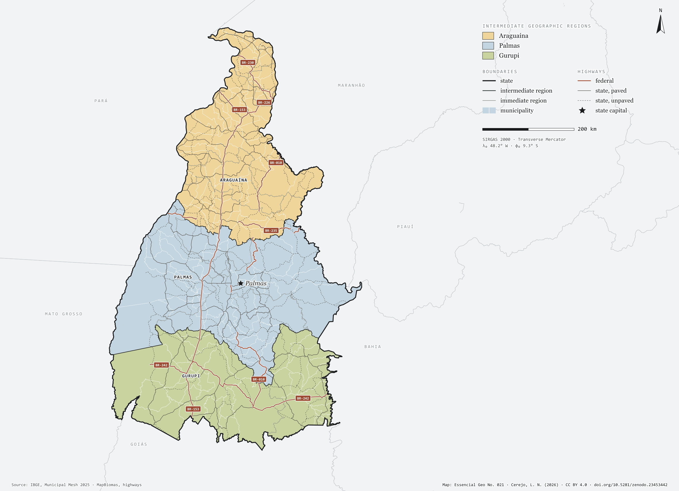
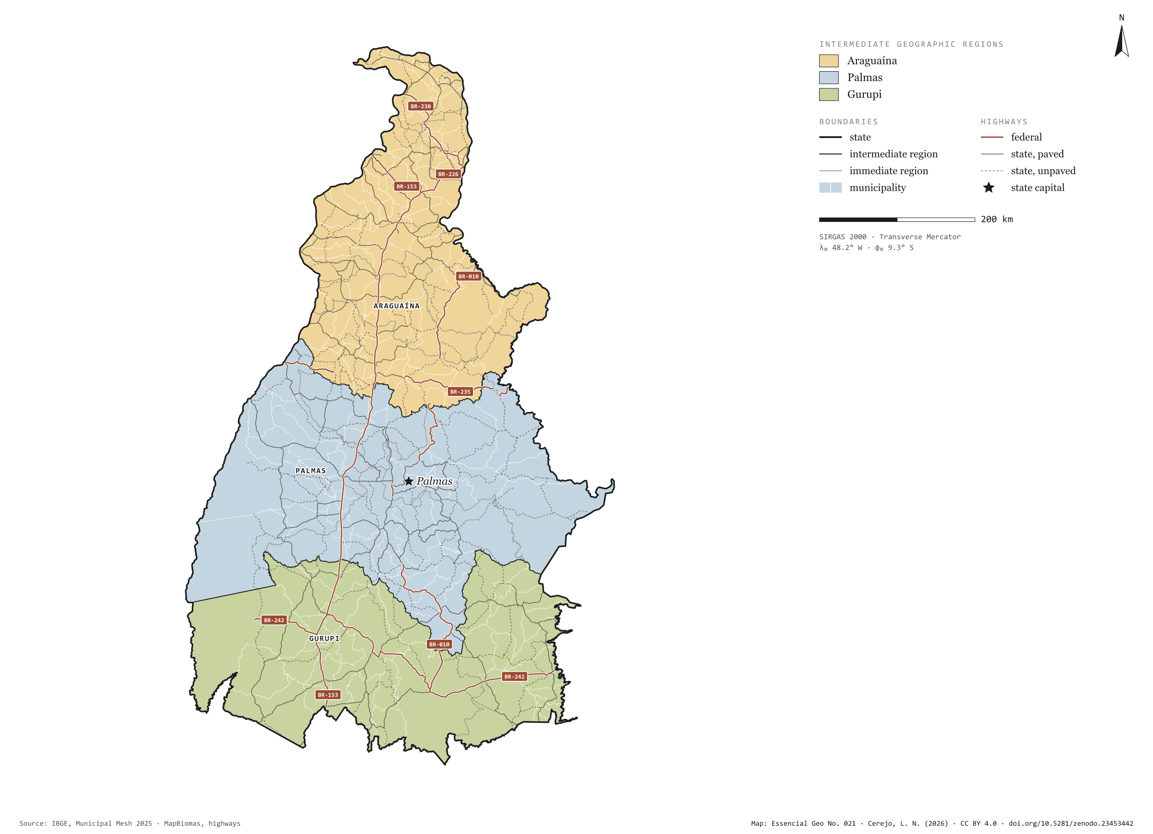
Fig. 021Tocantins state (TO)EPSG:4674Source: IBGE, MapBiomas, Natural Earth
Tocantins has 139 municipalities across 277,000 km², 3.3 per cent of Brazil. IBGE groups them into 11 immediate regions, drawn around the towns that supply jobs, trade and services to their surroundings, and into 3 intermediate regions that tie those networks together. Araguaína is the intermediate region with the most municipalities (65); Gurupi, the one with the fewest (32). The largest municipality is Formoso do Araguaia (13,432 km²); the smallest, Axixá do Tocantins (154 km²). Part of the series “Brazil, state by state”: a clean base, with official boundaries and the road network, to start a map without losing the first afternoon gathering files.
Technical record · downloads · citation
At a glance
Municipalities per intermediate region (municipalities)
Araguaína65
Palmas42
Gurupi32
Area
277,424km²
Largest municipality: Formoso do Araguaia (13,432 km²); smallest: Axixá do Tocantins (154 km²)
Paved highways
7,467km
2,244 km federal and 12,682 km state highways, paved or not
Layers
municipiospolygon139 municipalities, with IBGE code, regions, urban concentration and area (km²)
regioes_intermediariaspolygon3 intermediate geographic regions
regioes_imediataspolygon11 immediate geographic regions
limite_estadualpolygonBoundary of the federative unit
rodoviaslineFederal and state highways: route number, surface, physical status, carriageways
capitalpointIndicative point for the capital (not the exact seat)
The map without a frame, with legend, scale, reference system and credit written on it: ready for papers, lectures and slides. In two versions: with the basemap (neighbours and sea) or only the mapped area, on white.
CEREJO, Lucas Nakamura. Tocantins: divisão territorial e rodovias. Versão 1.0.0. [S. l.]: Zenodo, 2026. Conjunto de dados. DOI: 10.5281/zenodo.23453442. Disponível em: https://doi.org/10.5281/zenodo.23453442. Acesso em: 10 nov. 2026.
Cerejo, L. N. (2026). Tocantins: divisão territorial e rodovias [Tocantins: Territorial divisions and highways] (Version 1.0.0) [Data set]. Zenodo. https://doi.org/10.5281/zenodo.23453442
@dataset{cerejo2026_estado_tocantins,
  author    = {Cerejo, Lucas Nakamura},
  title     = {Tocantins: Divisão territorial e rodovias},
  year      = {2026},
  publisher = {Zenodo},
  version   = {1.0.0},
  doi       = {10.5281/zenodo.23453442},
  url       = {https://doi.org/10.5281/zenodo.23453442},
  language  = {portuguese},
  note      = {English title: Tocantins: Territorial divisions and highways. Licence CC BY 4.0}
}