Sewage on the mains
The mains cover the city; the countryside stays on the tank
Record, downloads and citationIn 2022, 91.3% of households in São Paulo state had their sewage connected to the mains, to the storm drain or to a septic tank linked to the mains: 14.8 million out of 16.2 million. 1.41 million were missing. Painted tract by tract, the map shows the mains as an urban thing: three households in four live in tracts where over 99% are connected, but those tracts are small, and the cream of the rural tracts, where almost no one is on the mains, covers most of the state. The city of São Paulo has 205,630 households off the mains, the largest absolute number; among towns with more than 20,000 households, Ibiúna has the largest share off the mains (71%). First plate of the collection “Sanitation and biomethane”.
Technical record · downloads · citation
At a glance
- up to 10% 4.3%
- 10 to 50% 3.6%
- 50 to 80% 3.2%
- 80 to 95% 5.8%
- 95 to 99% 9.4%
- over 99% 73.7%
91 %
205,630 households
Layers
- setores polygon 103,319 census tracts: households by sewage and rubbish destination, mains-connection class, leading destination and uncollected-rubbish class
- regioes_intermediarias polygon 11 intermediate geographic regions
- limite_estadual polygon State boundary
Metadata
- Sources
- IBGE — 2022 Population Census: household characteristics by census tract (2022)
IBGE — SIDRA, table 6805: households by type of sewage disposal (2022)
IBGE — 2022 Census Tract Mesh (2022) - Extent
- São Paulo State (SP)
- CRS / Projection
- SIRGAS 2000 (EPSG:4674)
EPSG:4674 - Software
- Node.js · d3-geo · QGIS
- Method
- Share of each census tract’s occupied permanent private households whose sewage goes to the mains, the storm drain or a tank linked to the mains, in six classes; tracts with withheld values get a class only when it does not depend on the omitted value.
- Version
- v1.0.0
- Licence
- CC BY 4.0
Downloads
- GPKG Tracts (with the data of plates 051 to 053), regions and boundary, SIRGAS 2000, with QGIS styles (.gpkg) 23.9 MB
- SVG Vector plate, for printing (.svg) 4.5 MB
- PNG Plate (PNG, 2400 px) (.png) 0.4 MB

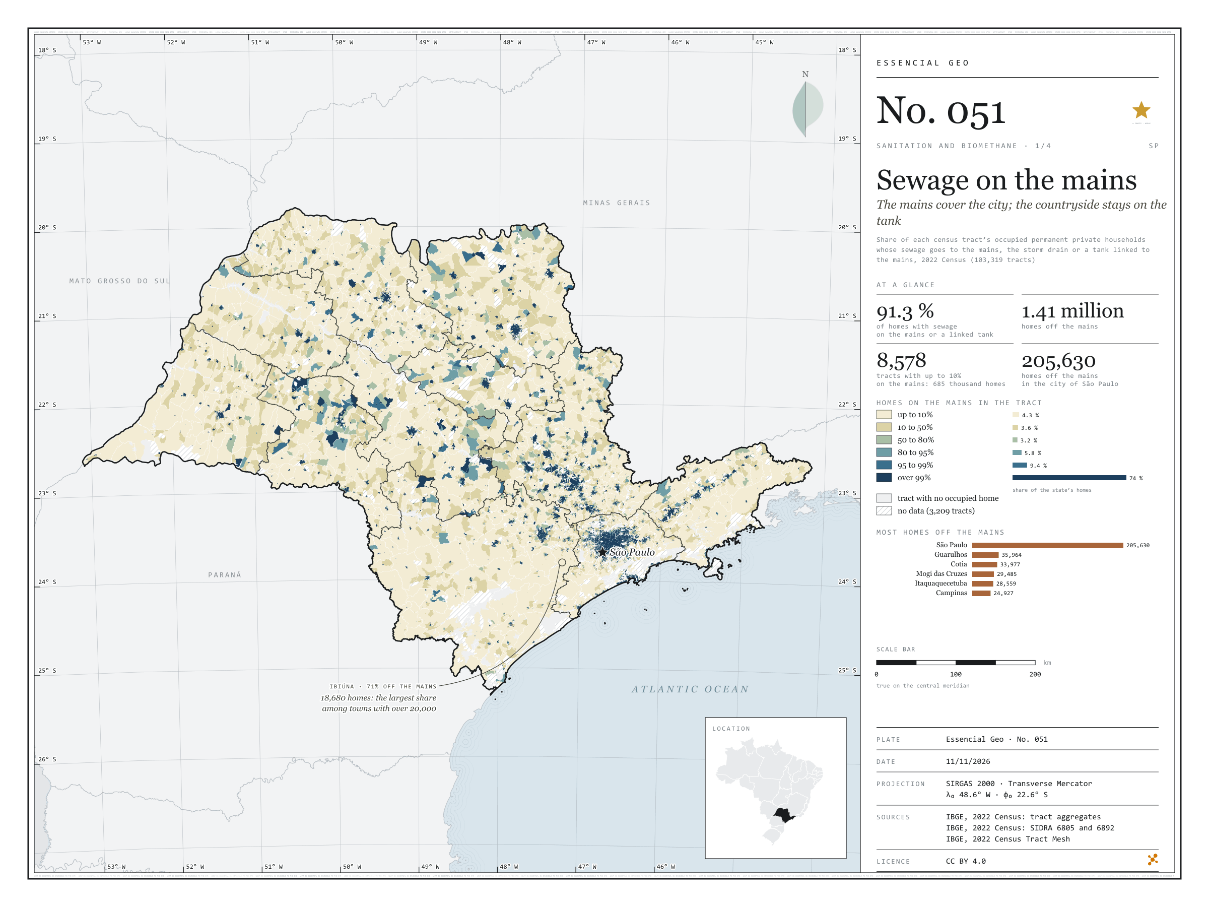
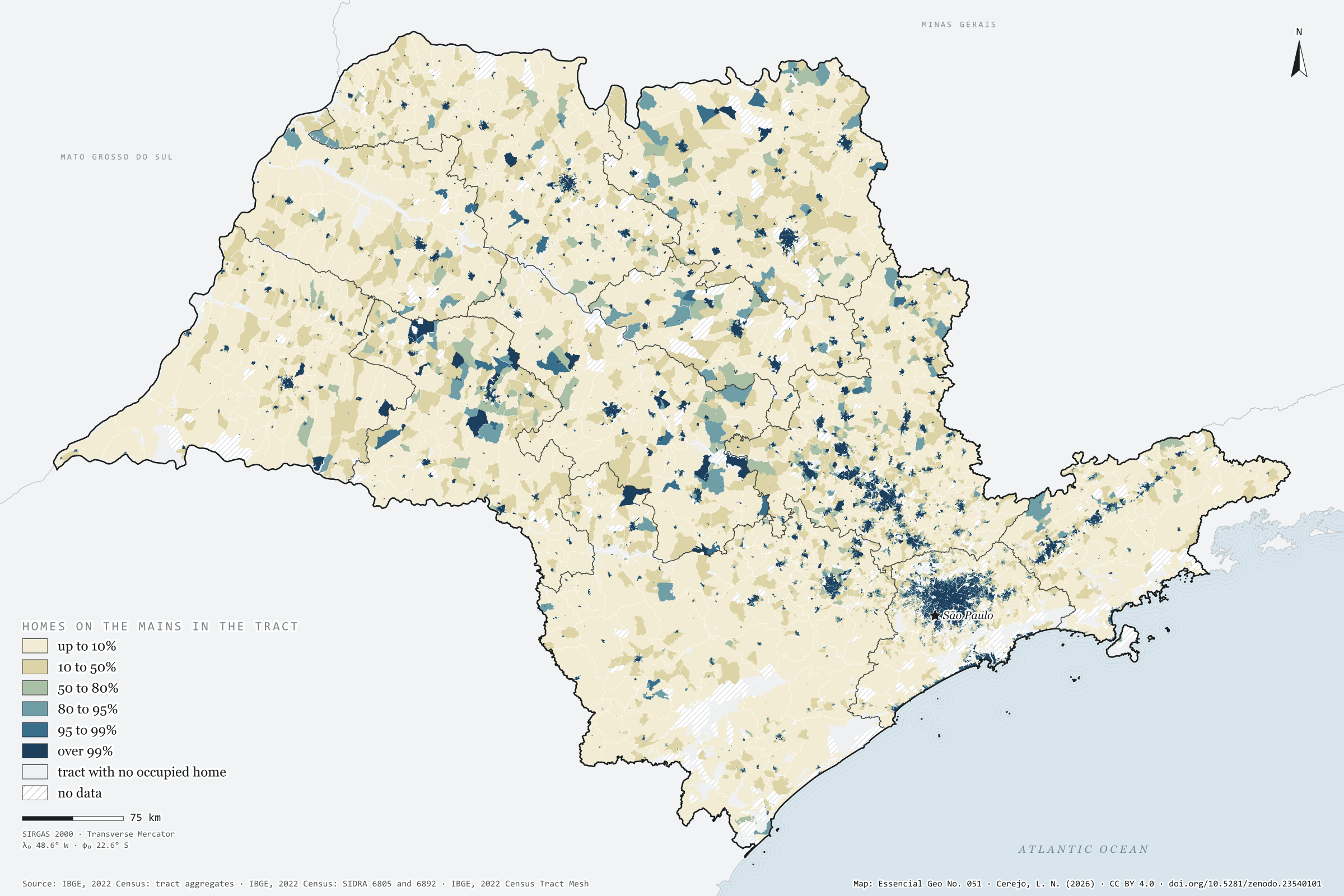
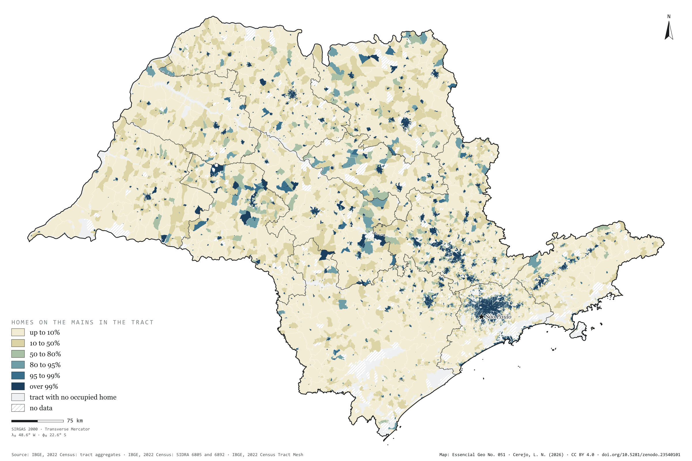
Figure to reuse
The map without a frame, with legend, scale, reference system and credit written on it: ready for papers, lectures and slides. In two versions: with the basemap (neighbours and sea) or only the mapped area, on white.
With basemap (PNG) Without basemap (PNG) QR code (SVG)
Point a camera at it to open this page.
How to cite
CEREJO, Lucas Nakamura. Esgoto na rede: a rede cobre a cidade; o campo fica na fossa. Versão 1.0.0. [S. l.]: Zenodo, 2026. Conjunto de dados. DOI: 10.5281/zenodo.23540101. Disponível em: https://doi.org/10.5281/zenodo.23540101. Acesso em: 10 nov. 2026.
Cerejo, L. N. (2026). Esgoto na rede: a rede cobre a cidade; o campo fica na fossa [Sewage on the mains: The mains cover the city; the countryside stays on the tank] (Version 1.0.0) [Data set]. Zenodo. https://doi.org/10.5281/zenodo.23540101
@dataset{cerejo2026_esgoto_na_rede_sp,
  author    = {Cerejo, Lucas Nakamura},
  title     = {Esgoto na rede: A rede cobre a cidade; o campo fica na fossa},
  year      = {2026},
  publisher = {Zenodo},
  version   = {1.0.0},
  doi       = {10.5281/zenodo.23540101},
  url       = {https://doi.org/10.5281/zenodo.23540101},
  language  = {portuguese},
  note      = {English title: Sewage on the mains: The mains cover the city; the countryside stays on the tank. Licence CC BY 4.0}
}