Biomethane and the power grid
The wire reaches closer than the pipe
Record, downloads and citationWhere there is no pipeline, biogas can become electricity on the spot and leave by wire. In São Paulo, the basic grid, from 230 kV up, adds up to 19,100 km of lines and 91 substations, and covers the state far better than gas pipelines: 58% of the biomethane potential lies within 10 km of a transmission line, and only 1% over 50 km. The bottleneck is the substation, where power enters the grid: 65% of the potential lies over 25 km from one, measured from the municipality’s centre. Valparaíso, in the west, has 197,000 m³ of possible biomethane a day 2.6 km from a line, but 52 km from the nearest substation. On the previous plate, gas from the sugarcane north lay far from the pipe; here, the wire runs right over it. Fourth plate of the collection “Biogas on the ground”.
Technical record · downloads · citation
At a glance
- up to 10 km 57.7%
- 10 to 25 km 34.8%
- 25 to 50 km 6.6%
- over 50 km 0.9%
- up to 10 km 6.9%
- 10 to 25 km 27.6%
- 25 to 50 km 47.4%
- over 50 km 18.1%
Layers
- municipios polygon 645 municipalities: potential and distances to lines and substations (same GPKG as plate 055)
- linhas_transmissao line 493 lines of 230 kV or more, 19,100 km inside SP
- subestacoes point 185 basic-grid substations, 91 in SP
Metadata
- Sources
- CP2B (Unicamp) — biogas and biomethane potential by municipality, method v5.1 (2026)
EPE — WebMap: existing transmission lines and substations, as published in the MapBiomas infrastructure database (2022)
IBGE — Municipal Mesh 2025 (2025) - Extent
- São Paulo State (SP)
- CRS / Projection
- SIRGAS 2000 (EPSG:4674)
EPSG:4674 - Software
- Node.js · d3-geo · QGIS
- Method
- Straight-line distance from each municipality’s interior point to the nearest basic-grid transmission line and substation, in four bands, crossed with the biomethane potential (CP2B method v5.1, level N4, reference scenario).
- Version
- v1.0.0
- Licence
- CC BY 4.0
- DOI
- being registered on Zenodo
Downloads
- GPKG Municipalities and infrastructure (same file as plates 055 to 059), SIRGAS 2000, with QGIS styles (.gpkg) 4.9 MB
- SVG Vector plate, for printing (.svg) 2.5 MB
- PNG Plate (PNG, 2400 px) (.png) 0.5 MB

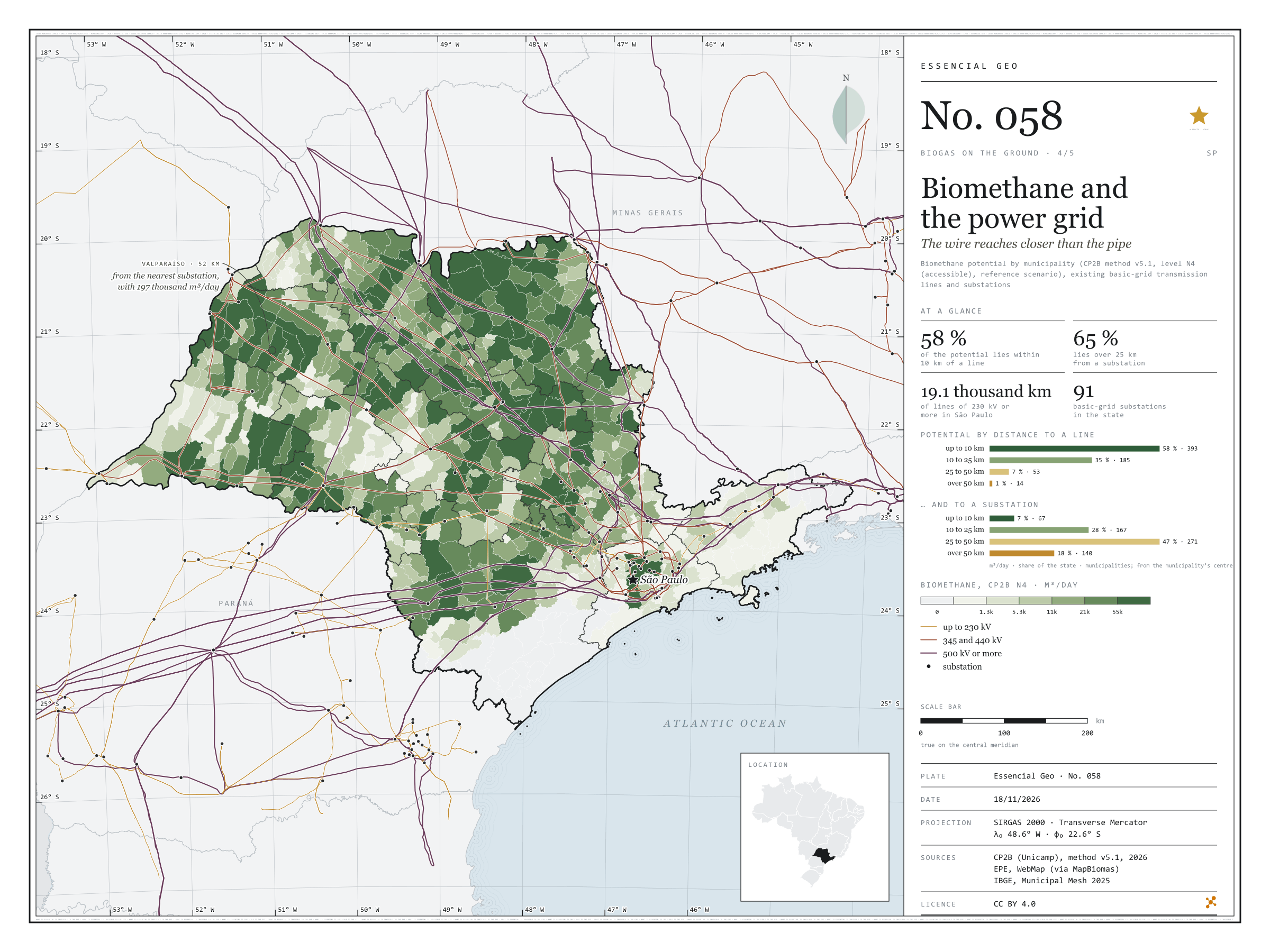
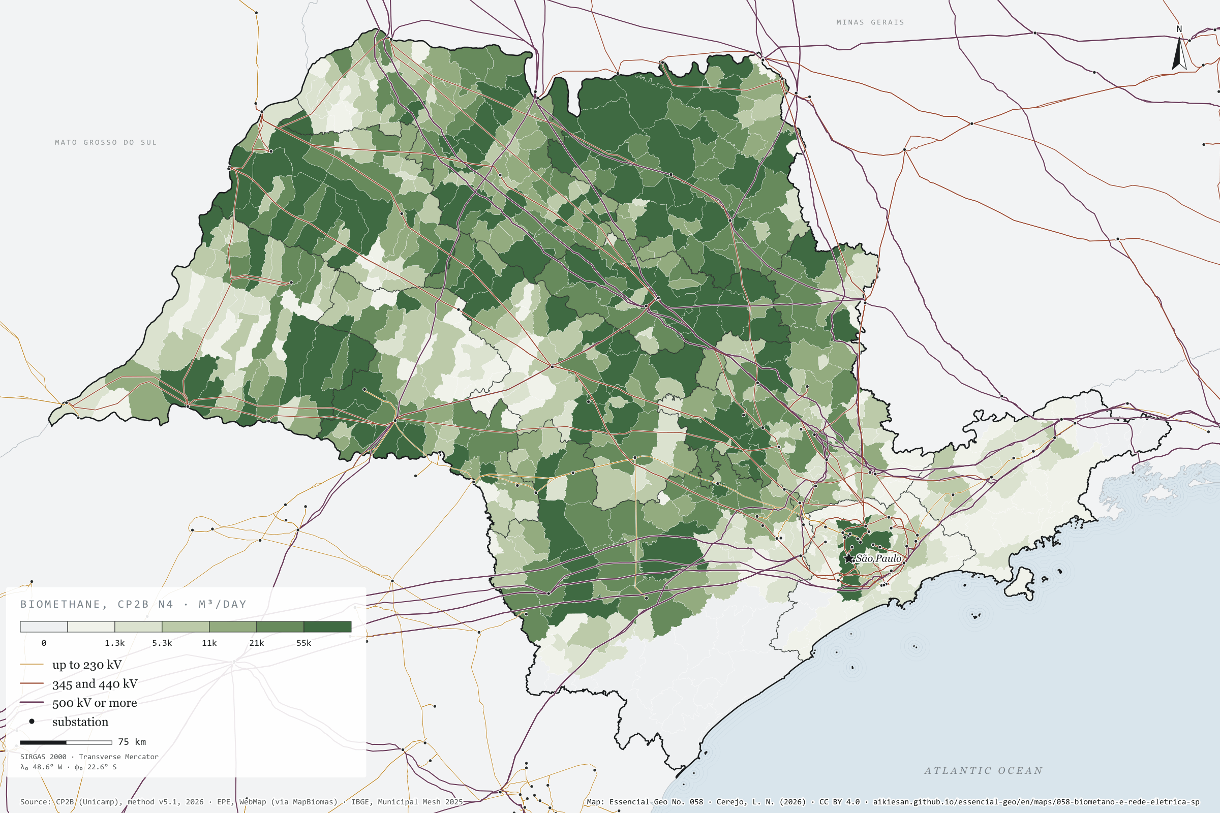
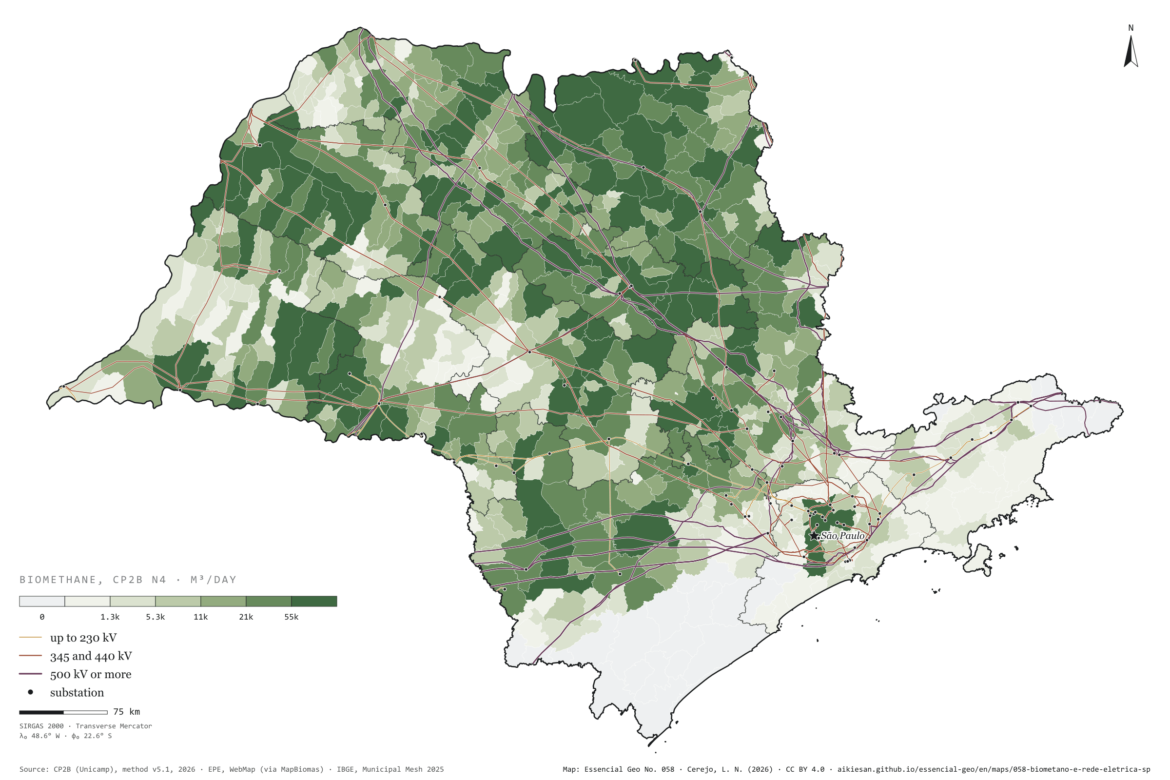
Figure to reuse
The map without a frame, with legend, scale, reference system and credit written on it: ready for papers, lectures and slides. In two versions: with the basemap (neighbours and sea) or only the mapped area, on white.
With basemap (PNG) Without basemap (PNG) QR code (SVG)
Point a camera at it to open this page.
How to cite
CEREJO, Lucas Nakamura. Biometano e rede elétrica: o fio chega mais perto do que o cano. Versão 1.0.0. [S. l.]: Essencial, 2026. Conjunto de dados. Disponível em: https://aikiesan.github.io/essencial-geo/en/maps/058-biometano-e-rede-eletrica-sp/. Acesso em: 10 nov. 2026.
Cerejo, L. N. (2026). Biometano e rede elétrica: o fio chega mais perto do que o cano [Biomethane and the power grid: The wire reaches closer than the pipe] (Version 1.0.0) [Data set]. Essencial. https://aikiesan.github.io/essencial-geo/en/maps/058-biometano-e-rede-eletrica-sp/
@dataset{cerejo2026_biometano_e_rede_eletrica_sp,
  author    = {Cerejo, Lucas Nakamura},
  title     = {Biometano e rede elétrica: O fio chega mais perto do que o cano},
  year      = {2026},
  publisher = {Essencial},
  version   = {1.0.0},
  url       = {https://aikiesan.github.io/essencial-geo/en/maps/058-biometano-e-rede-eletrica-sp/},
  language  = {portuguese},
  note      = {English title: Biomethane and the power grid: The wire reaches closer than the pipe. Licence CC BY 4.0}
}