Milk
Almost everywhere, at the lowest volume on record
Record, downloads and citationSão Paulo produced 1.51 billion litres of cow’s milk in 2024, the lowest volume since 2008. The peak came in 2015, at 1.77 billion; since then production has fallen by 15%, while Brazil’s rose to 35.7 billion litres. The state’s share went from 5.8% in 2008 to 4.2%. Milk is the most widespread animal product in the state: 603 of the 645 municipalities report some, and the ten largest add up to only 18%. Tapiratiba, in the north-east, leads with 41.5 million litres, 2.8% of the total, followed by Araras, Descalvado and Cunha. The darkest tones appear in the west, the north-east and the Paraíba valley, where Cunha and São Luiz do Paraitinga are among the six largest. The Campinas and São José dos Campos regions produce a third of the state’s milk. Second plate of the collection “Milk, eggs, honey and fish”.
Technical record · downloads · citation
At a glance
1,505,077 thousand litres
603
Layers
- municipios polygon 645 municipalities: milk production in 2008 and 2024 (thousand litres), data status in 2024 and dairy-cattle biomethane
- regioes_intermediarias polygon 11 intermediate geographic regions
- limite_estadual polygon State boundary
Metadata
- Sources
- IBGE — Municipal Livestock Survey (PPM), table 74: animal products (2008 a 2024)
CP2B (Unicamp) — biogas and biomethane potential by municipality, method v5.1 (2026)
IBGE — Municipal Mesh 2025 (2025) - Extent
- São Paulo state (SP)
- CRS / Projection
- SIRGAS 2000 (EPSG:4674)
EPSG:4674 - Software
- Python · GeoPandas · GDAL · QGIS · Node.js · d3-geo
- Method
- Cow’s milk production from PPM 2024 by municipality in six quantile classes; state series from 2008 to 2024; biomethane potential of dairy-cattle manure (in the files only) at the accessible level of the CP2B method.
- Version
- v1.0.0
- Licence
- CC BY 4.0
- DOI
- being registered on Zenodo
Downloads
- GPKG Three layers, SIRGAS 2000, with QGIS styles (.gpkg) 18.5 MB
- CSV Milk in 2008 and 2024 and dairy-cattle biomethane by municipality (.csv) 41 kB
- SVG Vector plate, for printing (.svg) 2.2 MB
- PNG Plate (PNG, 2400 px) (.png) 0.3 MB

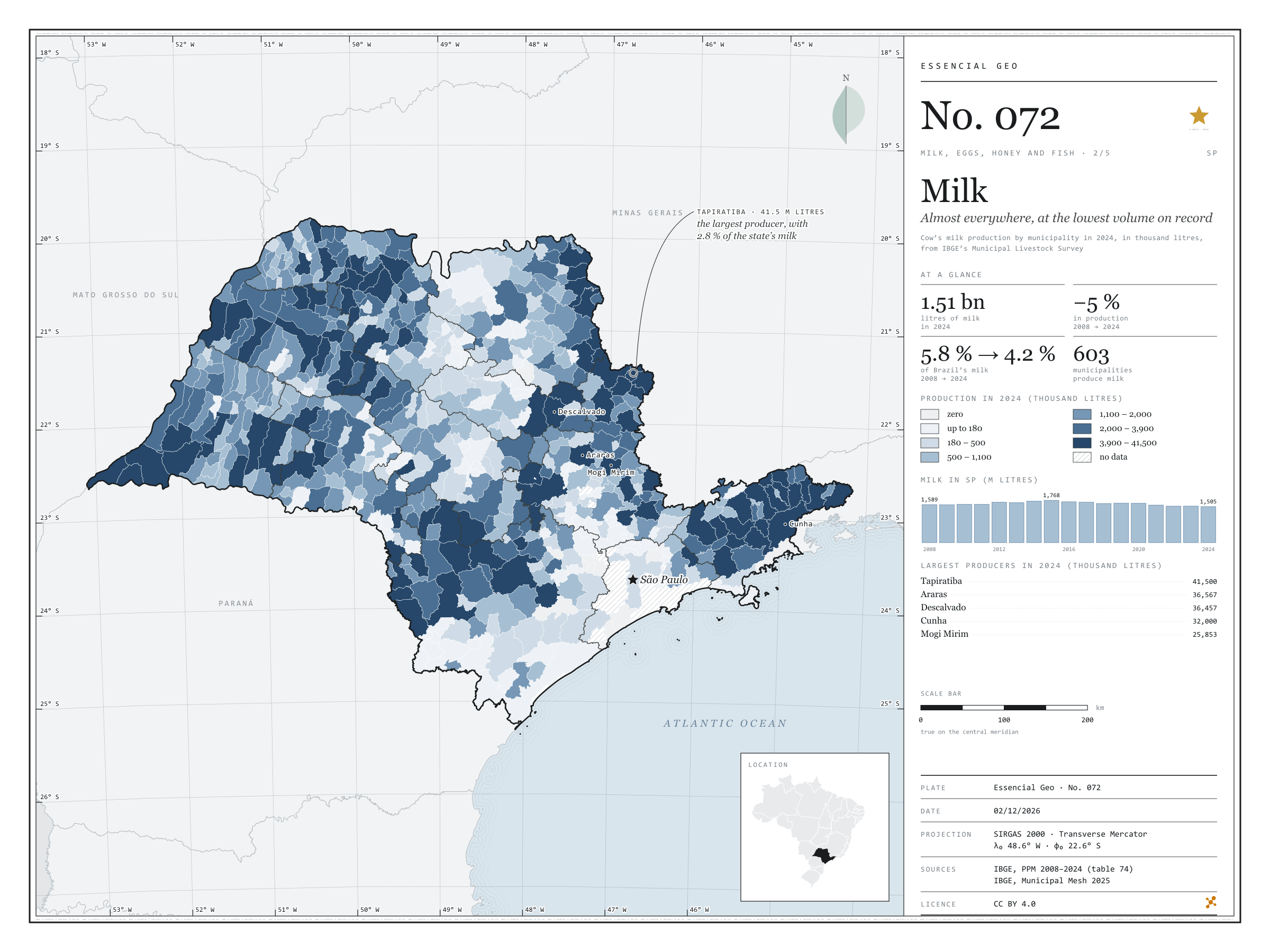
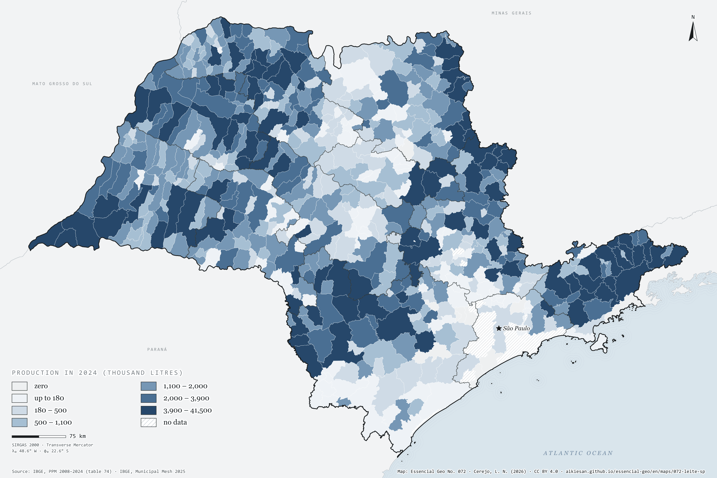
Figure to reuse
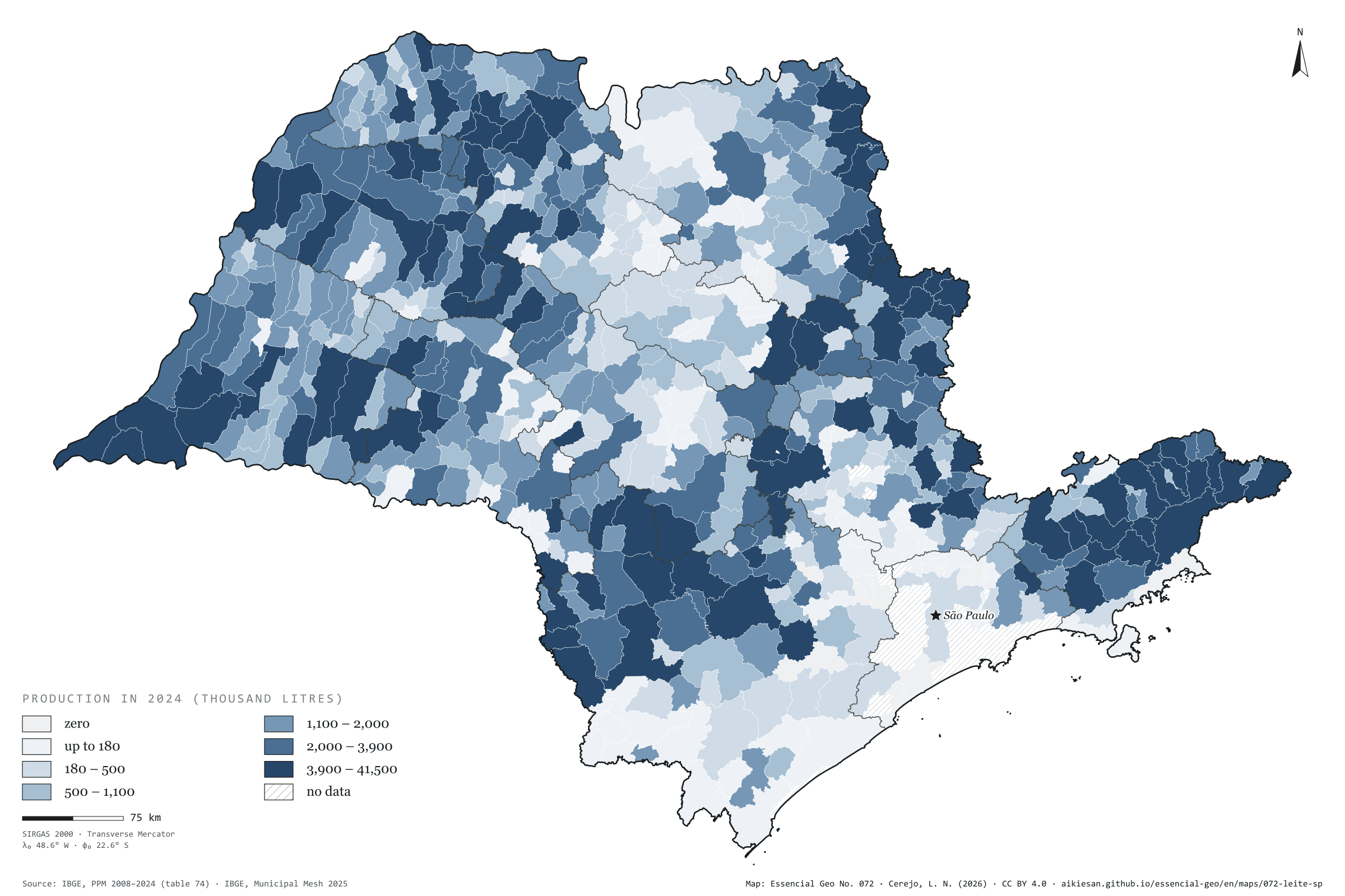
The map without a frame, with legend, scale, reference system and credit written on it: ready for papers, lectures and slides. In two versions: with the basemap (neighbours and sea) or only the mapped area, on white.
With basemap (PNG) Without basemap (PNG) QR code (SVG)
Point a camera at it to open this page.
How to cite
CEREJO, Lucas Nakamura. Leite: em quase todo o estado, no menor volume da série. Versão 1.0.0. [S. l.]: Essencial, 2026. Conjunto de dados. Disponível em: https://aikiesan.github.io/essencial-geo/en/maps/072-leite-sp/. Acesso em: 10 nov. 2026.
Cerejo, L. N. (2026). Leite: em quase todo o estado, no menor volume da série [Milk: Almost everywhere, at the lowest volume on record] (Version 1.0.0) [Data set]. Essencial. https://aikiesan.github.io/essencial-geo/en/maps/072-leite-sp/
@dataset{cerejo2026_leite_sp,
  author    = {Cerejo, Lucas Nakamura},
  title     = {Leite: Em quase todo o estado, no menor volume da série},
  year      = {2026},
  publisher = {Essencial},
  version   = {1.0.0},
  url       = {https://aikiesan.github.io/essencial-geo/en/maps/072-leite-sp/},
  language  = {portuguese},
  note      = {English title: Milk: Almost everywhere, at the lowest volume on record. Licence CC BY 4.0}
}