Skip to content
Essencial

No. 082 Land use Manure that feeds the soil 2/4

The phosphorus in manure

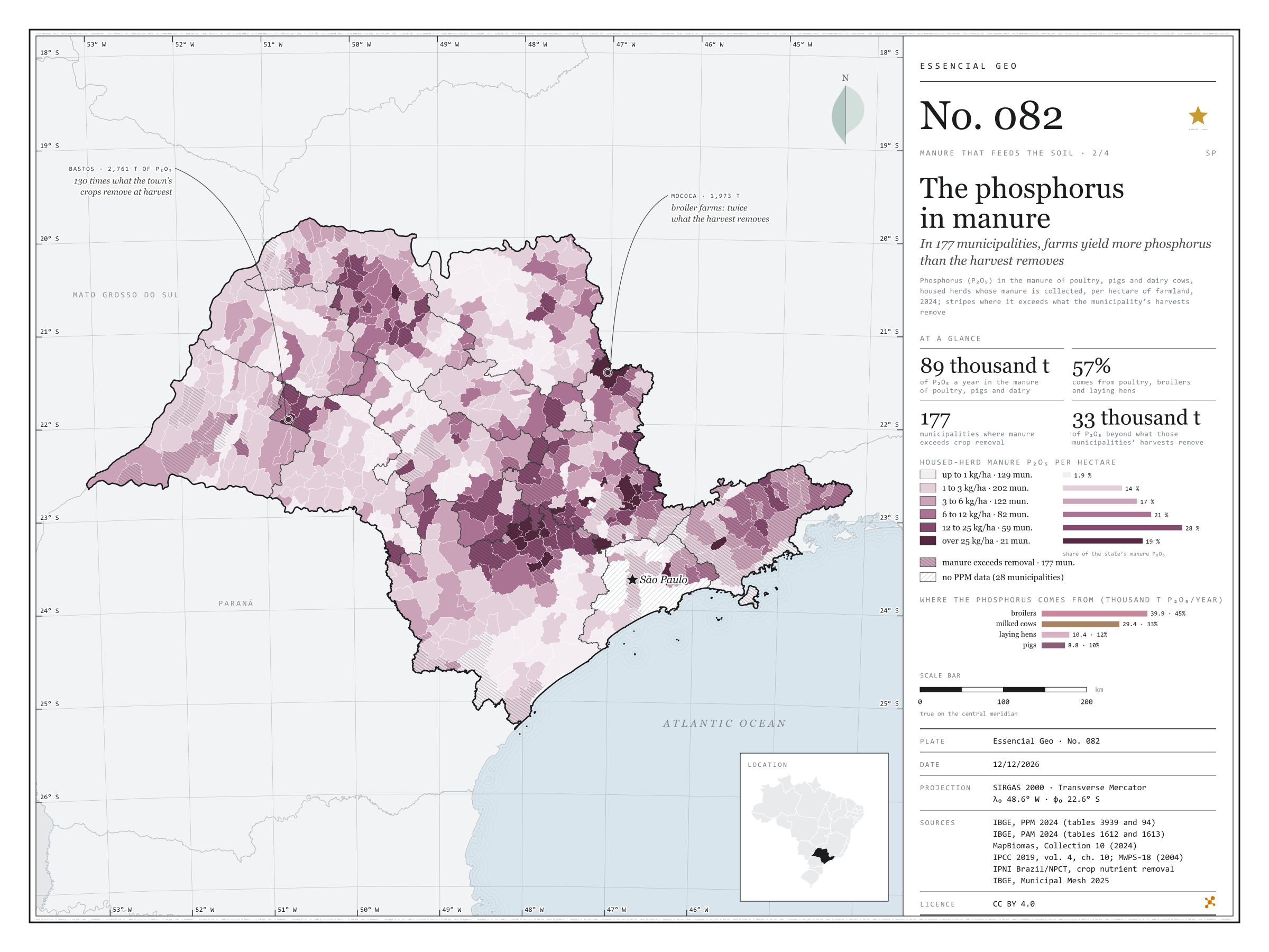
In 177 municipalities, farms yield more phosphorus than the harvest removes

Record, downloads and citation
Fig. 082 São Paulo State (SP) EPSG:4674 Source: IBGE, MapBiomas, IPCC, MidWest Plan Service, IPNI Brazil/NPCT

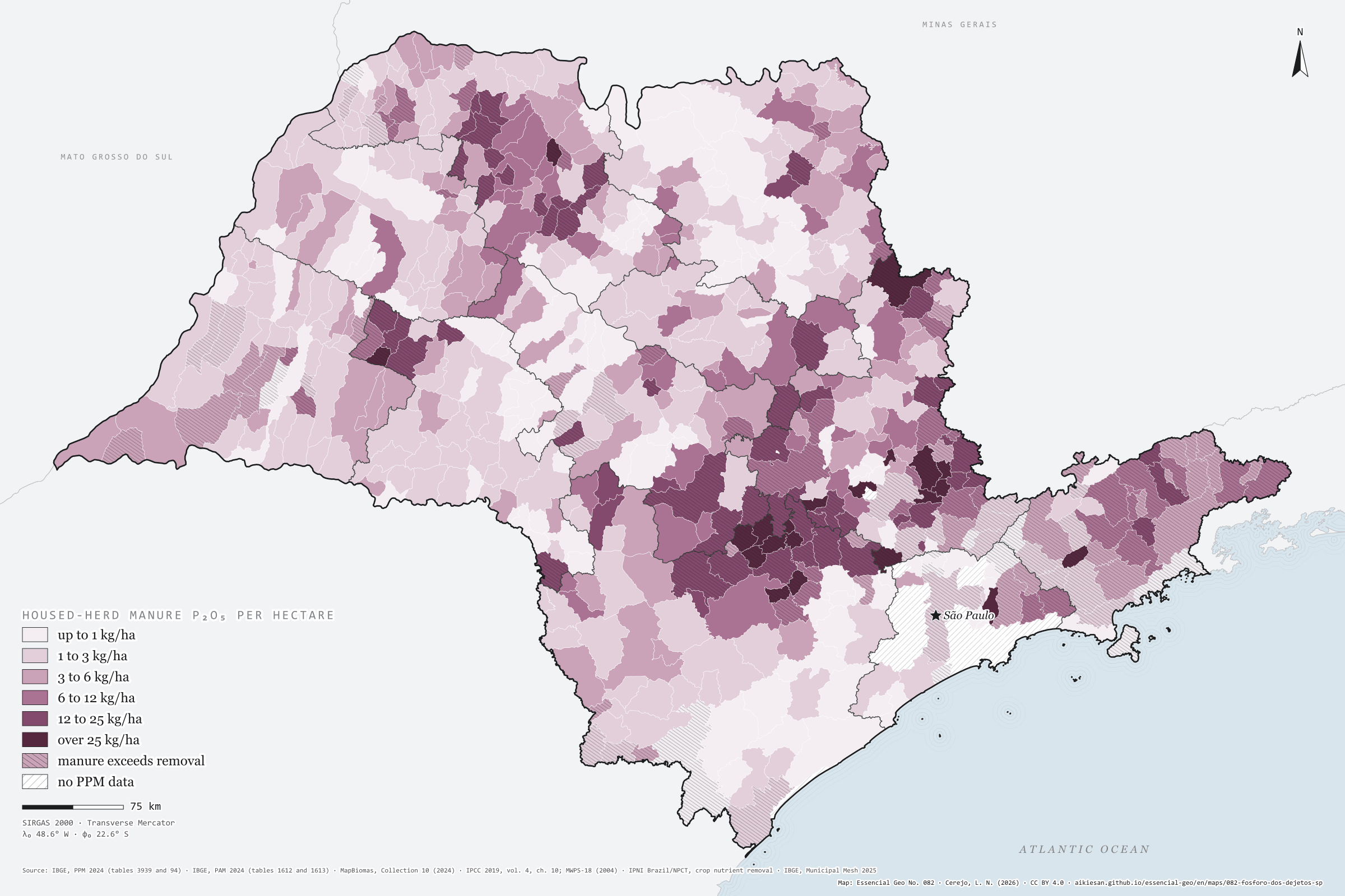
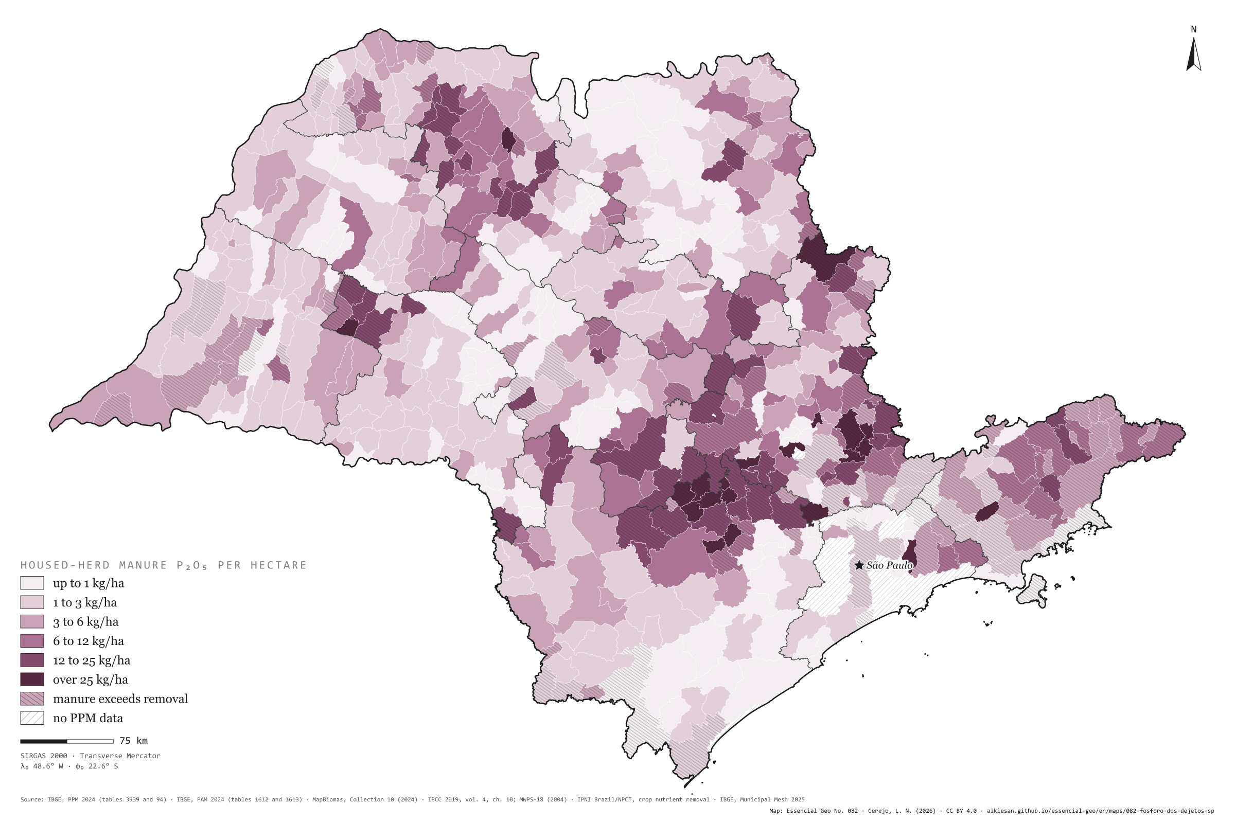
Poultry, pigs and dairy cows live in sheds and byres, and their manure can be collected: about 88,500 tonnes of P₂O₅ a year in São Paulo, 5.2 kg per farmland hectare. Broilers give 45%, milked cows 33%, laying hens 12% and pigs 10%. Phosphorus builds up where farms cluster: Bastos has 188 kg of P₂O₅ per hectare, Cerquilho 131, Jumirim 98, Cabreúva and Porangaba 81. In 177 municipalities, manure phosphorus exceeds what the municipality’s own harvests remove; together they hold 51,000 tonnes of P₂O₅ in manure, 33,000 more than their crops take. In Bastos, manure holds 130 times the phosphorus of the harvest; in Mococa, with 6.75 million broilers, twice as much. Second plate of the collection “Manure that feeds the soil”.

Technical record · downloads · citation

At a glance

Housed-herd manure P₂O₅ by the municipality’s kg per hectare class (t P₂O₅ a year)
  • up to 1 kg/ha 1.9%
  • 1 to 3 kg/ha 13.8%
  • 3 to 6 kg/ha 17.3%
  • 6 to 12 kg/ha 20.6%
  • 12 to 25 kg/ha 27.8%
  • over 25 kg/ha 18.6%
Manure P₂O₅ by herd (thousand t P₂O₅ a year)
  • broilers 40
  • milked cows 29
  • laying hens 10
  • pigs 8.8
Municipalities where manure phosphorus exceeds crop removal

177 municipalities

33,000 t of P₂O₅ beyond what the harvests remove

Layers

  • municipios polygon 645 municipalities: herds, housed-herd manure N, P₂O₅ and K₂O, P₂O₅ per hectare and crop removal (same GPKG as plate 081)
  • regioes_intermediarias polygon 11 intermediate geographic regions
  • limite_estadual polygon State boundary

Metadata

Sources
IBGE — 2024 Municipal Livestock Survey (SIDRA, tables 3939 and 94; table 94 retrieved from https://apisidra.ibge.gov.br/values/t/94/n6/in%20n3%2035/v/all/p/2024 on 18/10/2026) (2024)
IBGE — 2024 Municipal Agricultural Production (SIDRA, tables 1612 and 1613, variables 214 and 216; retrieved from https://apisidra.ibge.gov.br/values/t/1612/n6/in%20n3%2035/v/214/p/2024/c81/all and equivalents on 18/10/2026) (2024)
MapBiomas — Collection 10 of the Annual Series of Land Use and Land Cover Maps of Brazil, 2024 (farmland by municipality, from plate 045) (2024)
IPCC — 2019 Refinement to the 2006 IPCC Guidelines for National Greenhouse Gas Inventories, vol. 4, ch. 10 (tables 10.19 and 10A.5) (2019)
MidWest Plan Service — MWPS-18, Manure Characteristics, section 1, 2nd ed. (table 6) (2004)
IPNI Brazil/NPCT — Nutrient Balance Calculator (contents in the harvested product; Cunha, Casarin and Prochnow, Informações Agronômicas 130 and 145) (2014)
IBGE — Municipal Mesh 2025 (2025)
Extent
São Paulo State (SP)
CRS / Projection
SIRGAS 2000 (EPSG:4674)
EPSG:4674
Software
Node.js · d3-geo · QGIS
Method
Head counts of hens, broilers, pigs, sows and milked cows in the 2024 PPM times the P₂O₅ excreted per head per year (IPCC 2019 nitrogen times the MWPS-18 P₂O₅/N ratio), per hectare of 2024 MapBiomas farmland, in six classes; stripes where that P₂O₅ exceeds the municipality’s crop removal (2024 PAM × IPNI contents).
Version
v1.0.0
Licence
CC BY 4.0
DOI
being registered on Zenodo

Downloads

Figure to reuse

The map without a frame, with legend, scale, reference system and credit written on it: ready for papers, lectures and slides. In two versions: with the basemap (neighbours and sea) or only the mapped area, on white.

Point a camera at it to open this page.

How to cite

Cerejo, L. N. (2026). O fósforo dos dejetos: em 177 municípios, as granjas dão mais fósforo do que a colheita leva [The phosphorus in manure: In 177 municipalities, farms yield more phosphorus than the harvest removes] (Version 1.0.0) [Data set]. Essencial. https://aikiesan.github.io/essencial-geo/en/maps/082-fosforo-dos-dejetos-sp/

How to read this plate area, projection, scale, legend and source · 3 terms
1 Area
São Paulo State (SP) The area the plate covers. Outside it, neighbours and sea are drawn in grey, just for orientation.
2 Coordinates and projection
SIRGAS 2000 (EPSG:4674) The layers are in SIRGAS 2000; the drawing’s projection is written in the colophon at the foot of the panel.
3 Scale
Graphic scale bar in the panel The scale bar is true on the central meridian; away from it, measured distances vary a little.
4 Legend and layers
3 layers in the GeoPackage · polygon Read the legend before the map: it tells you whether a colour is a rate or a class, and whether a circle is a total.
5 Sources
IBGE (2024); MapBiomas (2024); IPCC (2019); MidWest Plan Service (2004); IPNI Brazil/NPCT (2014); IBGE (2025) Every figure comes from a public source, with its year. The data sheet gives each one’s address.

Terms on this plate

Harvest year
Cane years are not calendar years: in the Centre-South the harvest runs from April to March; in the Northeast, from September to August. That is why the two regions crush in opposite months.
Land cover and land use
What covers each patch of ground (forest, pasture, soy, cane, water, town), read from satellite images year by year. The forty-year plates use MapBiomas’ series, 1985 to 2025, summed by municipality.
MapBiomas
A network of universities, NGOs and companies that classifies land cover across all of Brazil from Landsat images, one map a year since 1985, as open data.

Download

Layers, table and figures, under CC BY 4.0. Cite with the DOI.

Full record and citation

Method notes · No. 082

The phosphorus in poultry, pig and dairy manure

Português · English

Plate No. 082, the second of four in the collection Manure that feeds the soil. Nitrogen from all herds is on plate 081, with the collection’s GPKG and the coefficients table.

What the files contain

Layer (GPKG)GeometryContent
municipiospolygon645 municipalities: 2024 PPM herds; n_conf_t, p2o5_conf_t and k2o_conf_t (manure of hens, broilers, pigs, sows and milked cows); p2o5_kg_ha_agro; p2o5_exporta_t (crop removal, plate 083); the collection’s other fields
regioes_intermediarias, limite_estadualpolygonreference

The GPKG and CSV are the collection’s, published with plate 081 and repeated here; this plate’s QGIS style is p2o5_kg_ha_agro.

Method

  1. Housed herds only. Poultry, pigs and dairy cows are kept in sheds, pens and byres, and their manure is collected, stored and carted. Beef cattle and small ruminants, which leave their manure on pasture, are left out of this plate.
  2. P₂O₅ per head. Each animal’s nitrogen (IPCC 2019, as on plate 081) times the P₂O₅/N ratio of as-excreted manure in table 6 of MWPS-18 (2004). Per head per year: milked cow 37.2 kg; sow 12.2; pig 5.2; hen 0.18; broiler 0.27.
  3. Per hectare. Sum over the 2024 MapBiomas farmland, in six classes closed on the right: up to 1, 1 to 3, 3 to 6, 6 to 12, 12 to 25 and over 25 kg of P₂O₅ per hectare.
  4. Stripes. Where the P₂O₅ in that manure exceeds the P₂O₅ the municipality’s harvests remove, by the plate 083 calculation (2024 PAM production times IPNI Brazil contents in the harvested product).

Limitations

  • These are estimates. The P₂O₅/N ratio comes from North American herds (MWPS-18); feed and the use of phytase change manure phosphorus. Table 3 in Gatiboni and Nicoloso (Embrapa, 2019), based on Brazilian data, gives 36.8 kg of P₂O₅ a year for a dairy cow, close to the 37.2 used here.
  • More phosphorus in manure than in the harvest does not mean pollution: soil holds phosphorus, and manure can leave the municipality. The stripes show where the local account does not balance.
  • The PPM counts animals on a single day; broiler farms raise several flocks a year.
  • 28 municipalities with no PPM data are hatched as no data, never as zero.

View this map’s folder on GitHub

Technical record

Technical record · No. 082

The phosphorus in manure

At a glance

Housed-herd manure P₂O₅ by the municipality’s kg per hectare class (t P₂O₅ a year)
  • up to 1 kg/ha 1.9%
  • 1 to 3 kg/ha 13.8%
  • 3 to 6 kg/ha 17.3%
  • 6 to 12 kg/ha 20.6%
  • 12 to 25 kg/ha 27.8%
  • over 25 kg/ha 18.6%
Manure P₂O₅ by herd (thousand t P₂O₅ a year)
  • broilers 40
  • milked cows 29
  • laying hens 10
  • pigs 8.8
Municipalities where manure phosphorus exceeds crop removal

177 municipalities

33,000 t of P₂O₅ beyond what the harvests remove

Layers

  • municipios polygon 645 municipalities: herds, housed-herd manure N, P₂O₅ and K₂O, P₂O₅ per hectare and crop removal (same GPKG as plate 081)
  • regioes_intermediarias polygon 11 intermediate geographic regions
  • limite_estadual polygon State boundary

Metadata

Sources
IBGE — 2024 Municipal Livestock Survey (SIDRA, tables 3939 and 94; table 94 retrieved from https://apisidra.ibge.gov.br/values/t/94/n6/in%20n3%2035/v/all/p/2024 on 18/10/2026) (2024)
IBGE — 2024 Municipal Agricultural Production (SIDRA, tables 1612 and 1613, variables 214 and 216; retrieved from https://apisidra.ibge.gov.br/values/t/1612/n6/in%20n3%2035/v/214/p/2024/c81/all and equivalents on 18/10/2026) (2024)
MapBiomas — Collection 10 of the Annual Series of Land Use and Land Cover Maps of Brazil, 2024 (farmland by municipality, from plate 045) (2024)
IPCC — 2019 Refinement to the 2006 IPCC Guidelines for National Greenhouse Gas Inventories, vol. 4, ch. 10 (tables 10.19 and 10A.5) (2019)
MidWest Plan Service — MWPS-18, Manure Characteristics, section 1, 2nd ed. (table 6) (2004)
IPNI Brazil/NPCT — Nutrient Balance Calculator (contents in the harvested product; Cunha, Casarin and Prochnow, Informações Agronômicas 130 and 145) (2014)
IBGE — Municipal Mesh 2025 (2025)
Extent
São Paulo State (SP)
CRS / Projection
SIRGAS 2000 (EPSG:4674)
EPSG:4674
Software
Node.js · d3-geo · QGIS
Method
Head counts of hens, broilers, pigs, sows and milked cows in the 2024 PPM times the P₂O₅ excreted per head per year (IPCC 2019 nitrogen times the MWPS-18 P₂O₅/N ratio), per hectare of 2024 MapBiomas farmland, in six classes; stripes where that P₂O₅ exceeds the municipality’s crop removal (2024 PAM × IPNI contents).
Version
v1.0.0
Licence
CC BY 4.0
DOI
being registered on Zenodo

Downloads

Figure to reuse

The map without a frame, with legend, scale, reference system and credit written on it: ready for papers, lectures and slides. In two versions: with the basemap (neighbours and sea) or only the mapped area, on white.

Point a camera at it to open this page.

How to cite

Cerejo, L. N. (2026). O fósforo dos dejetos: em 177 municípios, as granjas dão mais fósforo do que a colheita leva [The phosphorus in manure: In 177 municipalities, farms yield more phosphorus than the harvest removes] (Version 1.0.0) [Data set]. Essencial. https://aikiesan.github.io/essencial-geo/en/maps/082-fosforo-dos-dejetos-sp/

100%