Skip to content
Essencial

No. 111 Energy · biomass Bioenergy, crossed 1/5

Cane in the tank

Where there is more cane, ethanol weighs more in what filling stations sell

Record, downloads and citation
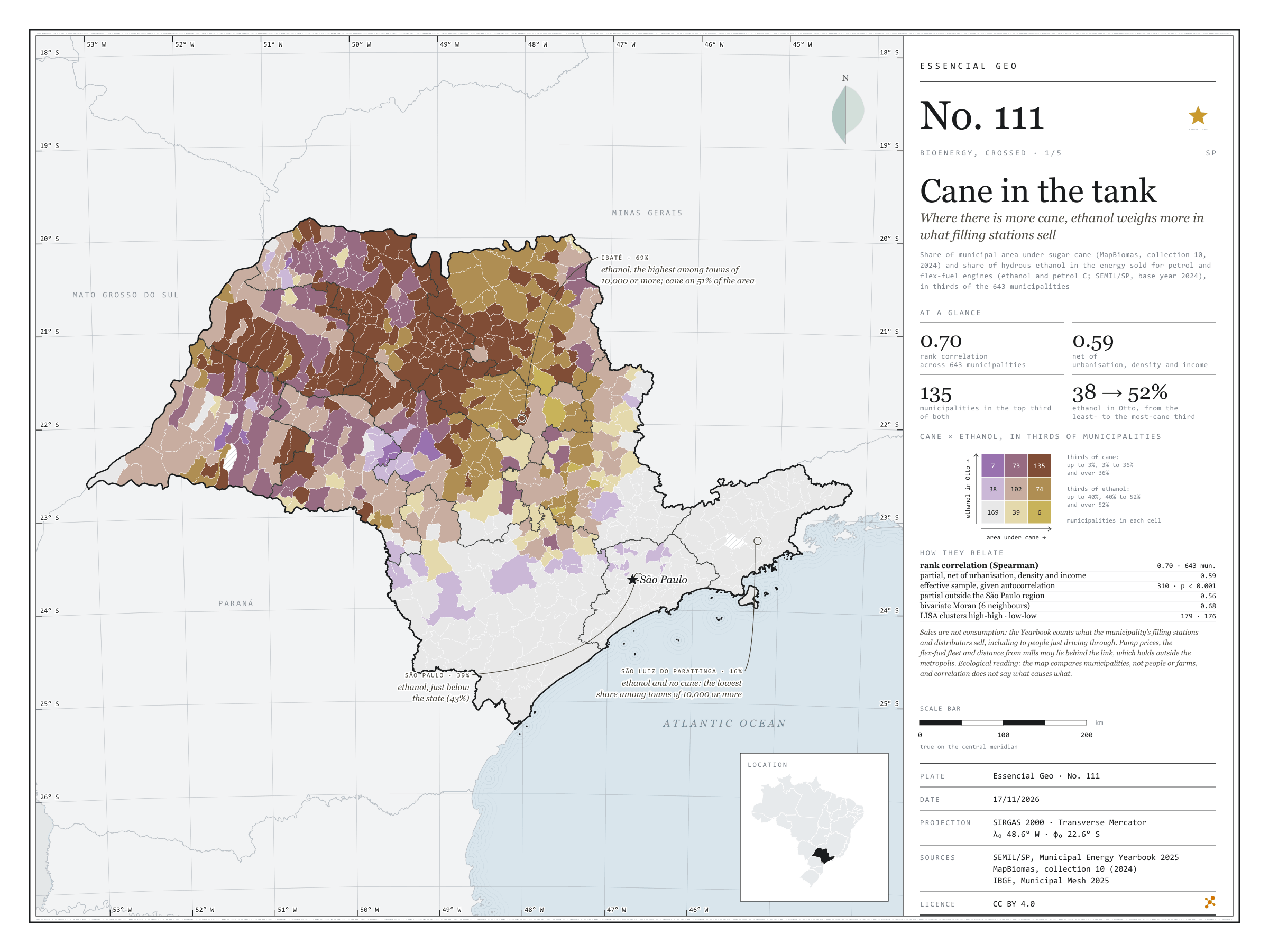
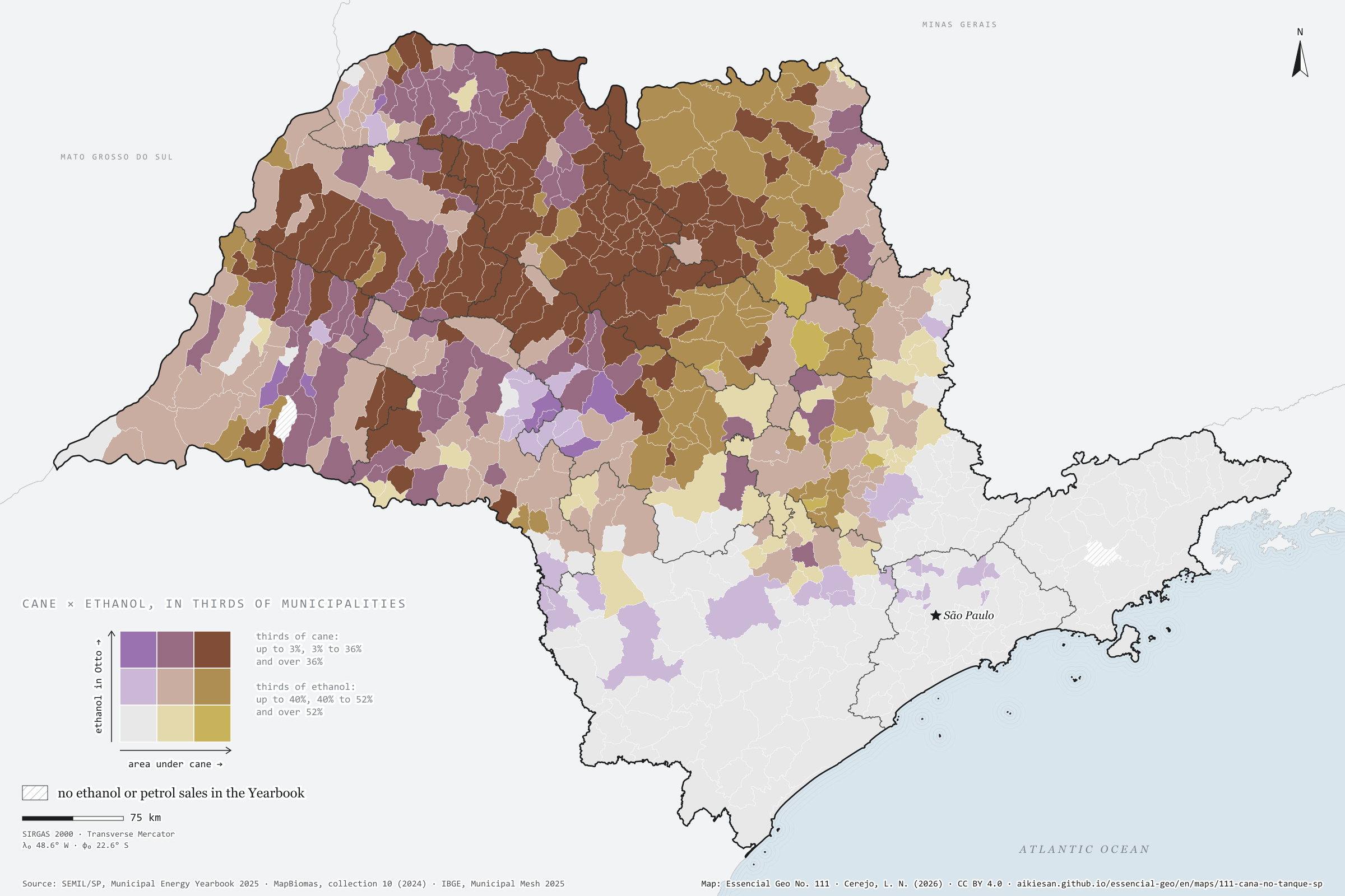
Fig. 111 São Paulo State (SP) EPSG:4674 Source: SEMIL/SP, Municipal Energy Yearbook 2025 (base year 2024): sales of hydrous ethanol, petrol C, diesel oil and piped natural gas by municipality, MapBiomas, IBGE

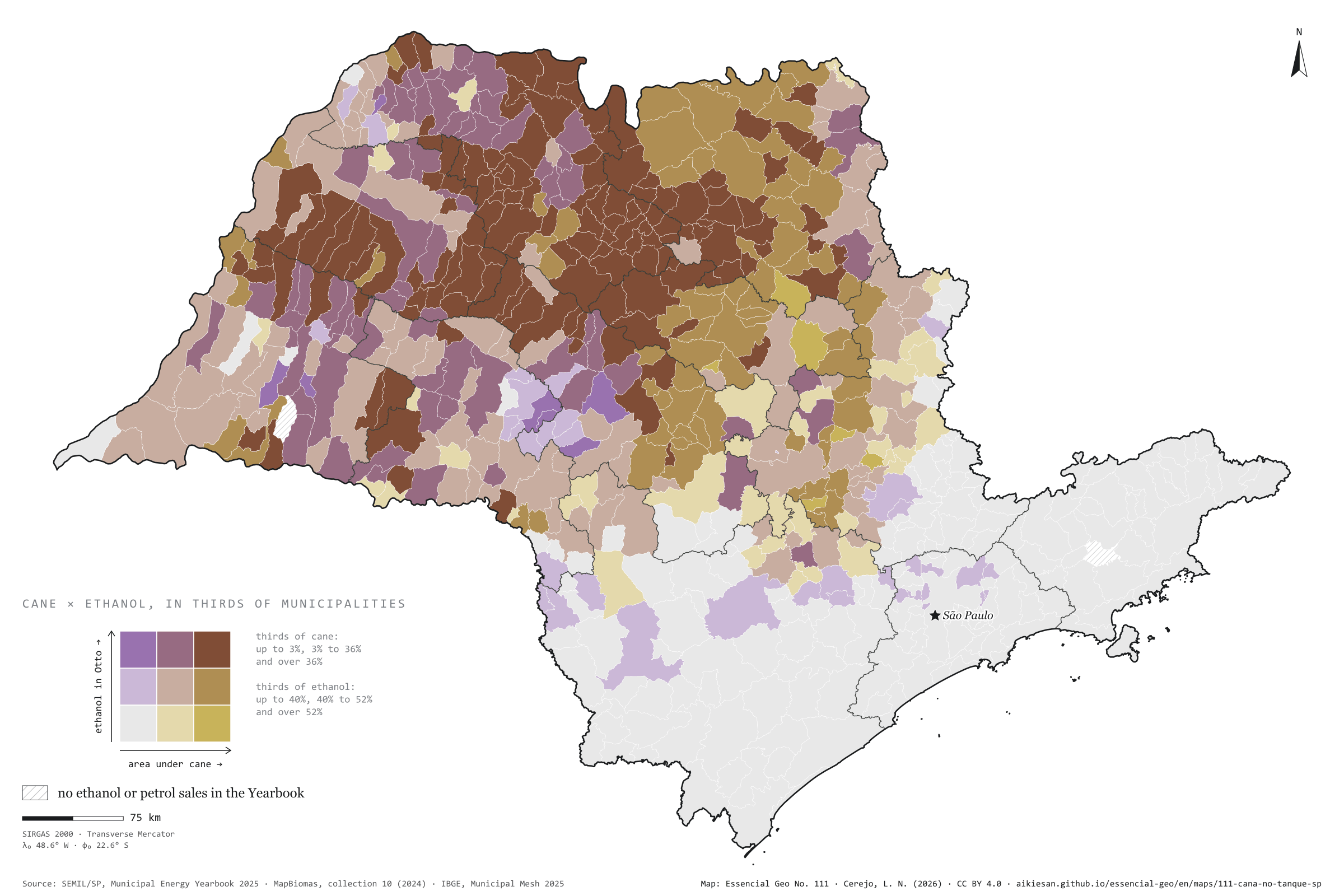
In São Paulo municipalities with more cane, ethanol weighs more in the fuel sold for petrol and flex-fuel engines. In energy, hydrous ethanol was 43% of Otto-cycle sales statewide in 2024; in the third of municipalities with least cane, 38%; in the third with most, 52%. The rank correlation is 0.70 and stays at 0.59 net of urbanisation, density and income. In Ibaté, with cane on 51% of its area, ethanol reaches 69%; in São Luiz do Paraitinga, with no cane, it is 16%. Sales are not consumption, and prices, the fleet and distance from mills may lie behind it. First plate of the collection “Bioenergy, crossed”.

Technical record · downloads · citation

At a glance

Rank correlation between cane and ethanol

0.7

partial 0.59; 643 municipalities

Ethanol in Otto-cycle sales, most-cane third

52 %

38% in the least-cane third; 43% statewide

Municipalities in the top third of both

135 municipalities

Layers

  • municipios polygon 645 municipalities with the variables of all five plates, the bivariate classes and the LISA clusters (same GPKG as plates 111 to 115)
  • gasodutos line Gas transmission pipelines and distribution network (EPE)
  • regioes_intermediarias polygon 11 intermediate geographic regions
  • limite_estadual polygon State boundary

Metadata

Extent
São Paulo State (SP)
CRS / Projection
SIRGAS 2000 (EPSG:4674)
EPSG:4674
Software
Node.js · d3-geo · QGIS
Method
Share of municipal area under sugar cane (MapBiomas, collection 10, 2024) and hydrous ethanol’s share of the energy sold in the Otto cycle (ethanol and petrol C, SEMIL/SP, base year 2024), each in thirds of municipalities, crossed in a 3 × 3 bivariate map; Spearman rank correlations, raw and partial, and bivariate LISA.
Version
v1.0.0
Licence
CC BY 4.0
DOI
being registered on Zenodo

Downloads

Figure to reuse

The map without a frame, with legend, scale, reference system and credit written on it: ready for papers, lectures and slides. In two versions: with the basemap (neighbours and sea) or only the mapped area, on white.

Point a camera at it to open this page.

How to cite

Cerejo, L. N. (2026). Cana no tanque: onde há mais canavial, o etanol pesa mais no que os postos vendem [Cane in the tank: Where there is more cane, ethanol weighs more in what filling stations sell] (Version 1.0.0) [Data set]. Essencial. https://aikiesan.github.io/essencial-geo/en/maps/111-cana-no-tanque-sp/

How to read this plate area, projection, scale, legend and source · 2 terms
1 Area
São Paulo State (SP) The area the plate covers. Outside it, neighbours and sea are drawn in grey, just for orientation.
2 Coordinates and projection
SIRGAS 2000 (EPSG:4674) The layers are in SIRGAS 2000; the drawing’s projection is written in the colophon at the foot of the panel.
3 Scale
Graphic scale bar in the panel The scale bar is true on the central meridian; away from it, measured distances vary a little.
4 Legend and layers
4 layers in the GeoPackage · polygon, line Read the legend before the map: it tells you whether a colour is a rate or a class, and whether a circle is a total.
5 Sources
SEMIL/SP, Municipal Energy Yearbook 2025 (base year 2024): sales of hydrous ethanol, petrol C, diesel oil and piped natural gas by municipality (2025); MapBiomas (2024); IBGE (2022); IBGE (2025) Every figure comes from a public source, with its year. The data sheet gives each one’s address.

Terms on this plate

Land cover and land use
What covers each patch of ground (forest, pasture, soy, cane, water, town), read from satellite images year by year. The forty-year plates use MapBiomas’ series, 1985 to 2025, summed by municipality.
MapBiomas
A network of universities, NGOs and companies that classifies land cover across all of Brazil from Landsat images, one map a year since 1985, as open data.

Download

Layers, table and figures, under CC BY 4.0. Cite with the DOI.

Full record and citation

Method notes · No. 111

Area under cane and ethanol’s share of what filling stations sell, across São Paulo’s municipalities

Português · English

Plate No. 111, the first of five in the collection Bioenergy, crossed; the next, plate 112.

The collection crosses São Paulo’s bioenergy with what filling stations sell, with the countryside and with town halls, across the state’s 645 municipalities. The pairs came from a correlation screen between CP2B biomethane potential, fuel sales in the SEMIL Yearbook, plantation forestry, the cattle herd, the Agricultural Census, the vehicle fleet and MUNIC. Each pair went through raw and partial rank correlation (net of urbanisation, density and income), an effective sample corrected for spatial autocorrelation, Benjamini–Hochberg q values and bivariate LISA. The last plate is descriptive, with no test, and the text says so.

The map’s callouts point to Ibaté, where ethanol is 69% of the energy sold in the Otto cycle (the highest among municipalities of 10,000 or more) and cane covers 51% of the area; São Luiz do Paraitinga, with no cane and 16% (the lowest); and São Paulo, at 39%, just below the state.

What the files contain

Layer (GPKG)GeometryContent
municipiospolygon645 municipalities with cane and ethanol, biomethane and diesel, the fleet, native cover and pulpwood, cattle and organic fertiliser, distances to the pipeline, piped gas and the MUNIC answers on waste; classes b111, b113, b114, arranjo115 and clusters lisa111, lisa113, lisa114
gasodutoslinetransmission pipelines and distribution network (tipo)
regioes_intermediarias, limite_estadualpolygonreference

The GPKG is the same for all five plates and carries a QGIS style for each. The CSV has the municipal table, without geometry. Empty fields are missing data, not zero. LISA clusters come as AA (high-high), BB (low-low), AB, BA and ns (not significant); the first letter is the municipality’s variable, the second its neighbours’.

Method

  1. pct_area_cana: area under sugar cane (MapBiomas, collection 10, 2024) over municipal area, in %.
  2. etanol_l and gasolina_l: litres of hydrous ethanol and petrol C sold in the municipality in 2024 (SEMIL/SP, Municipal Energy Yearbook 2025). pct_etanol_otto = ethanol × 21.3 MJ/L ÷ (ethanol × 21.3 + petrol C × 32.2 MJ/L), in %; petrol C already carries blended anhydrous ethanol, which stays in the petrol share.
  3. Thirds of cane: up to 3.4%, 3.4% to 35.6% and over 35.6%; of ethanol: up to 39.8%, 39.8% to 52.5% and over 52.5%. b111: bivariate class, tens = third of cane (1 to 3), units = third of ethanol (1 to 3). From bottom to top and left to right, the nine cells hold 169, 39, 6; 38, 102, 74; 7, 73, 135 municipalities. Anhumas and Redenção da Serra have no fuel sales in the Yearbook and are left out (643 municipalities).
  4. Cane × ethanol in the Otto cycle: Spearman rank correlation 0.70 (643 municipalities), partial 0.59, effective sample 310, p < 0.001, q < 0.001. Without the capital, 0.59; outside the São Paulo intermediate region, partial 0.56.
  5. lisa111: bivariate LISA clusters (cane in the municipality × ethanol in its neighbours): 179 high-high, 176 low-low, 2 high-low and 8 low-high; bivariate Moran’s I 0.68.
  6. Partial correlation: the correlation between the residuals of each variable’s ranks regressed on the ranks of the controls, which are urbanisation (residents in urban areas), log of population density and log of income per head (2022 Census). Effective sample under spatial autocorrelation: n·(1 − Iₓ·Iᵧ)/(1 + Iₓ·Iᵧ), where Iₓ and Iᵧ are the Moran’s I of the residuals over a 6-nearest-neighbour neighbourhood; Benjamini–Hochberg q values across all pairs in the screen. Bivariate LISA: the municipality’s value against the mean of its 6 neighbours on the other variable, 999 permutations, seed 20261019, p < 0.05.

Limitations

  • Sales are not consumption: the SEMIL Yearbook counts what filling stations and distributors sell in the municipality, including to people just driving through or to fleets based elsewhere. Towns on busy highways may sell far more diesel than they use.
  • Relative pump prices, the flex-fuel fleet and distance to the nearest mill may lie behind the link; the map does not separate these effects. Ethanol’s share is measured in energy, not litres: in litres it would be larger.
  • Ecological reading: the map compares municipalities, not people or farms. A correlation between municipalities does not say that the same farms or drivers have both traits, nor that one causes the other.

View this map’s folder on GitHub

Technical record

Technical record · No. 111

Cane in the tank

At a glance

Rank correlation between cane and ethanol

0.7

partial 0.59; 643 municipalities

Ethanol in Otto-cycle sales, most-cane third

52 %

38% in the least-cane third; 43% statewide

Municipalities in the top third of both

135 municipalities

Layers

  • municipios polygon 645 municipalities with the variables of all five plates, the bivariate classes and the LISA clusters (same GPKG as plates 111 to 115)
  • gasodutos line Gas transmission pipelines and distribution network (EPE)
  • regioes_intermediarias polygon 11 intermediate geographic regions
  • limite_estadual polygon State boundary

Metadata

Extent
São Paulo State (SP)
CRS / Projection
SIRGAS 2000 (EPSG:4674)
EPSG:4674
Software
Node.js · d3-geo · QGIS
Method
Share of municipal area under sugar cane (MapBiomas, collection 10, 2024) and hydrous ethanol’s share of the energy sold in the Otto cycle (ethanol and petrol C, SEMIL/SP, base year 2024), each in thirds of municipalities, crossed in a 3 × 3 bivariate map; Spearman rank correlations, raw and partial, and bivariate LISA.
Version
v1.0.0
Licence
CC BY 4.0
DOI
being registered on Zenodo

Downloads

Figure to reuse

The map without a frame, with legend, scale, reference system and credit written on it: ready for papers, lectures and slides. In two versions: with the basemap (neighbours and sea) or only the mapped area, on white.

Point a camera at it to open this page.

How to cite

Cerejo, L. N. (2026). Cana no tanque: onde há mais canavial, o etanol pesa mais no que os postos vendem [Cane in the tank: Where there is more cane, ethanol weighs more in what filling stations sell] (Version 1.0.0) [Data set]. Essencial. https://aikiesan.github.io/essencial-geo/en/maps/111-cana-no-tanque-sp/

100%