Manure far from who spreads it
Where there are more cattle per km², fewer farms use organic fertiliser
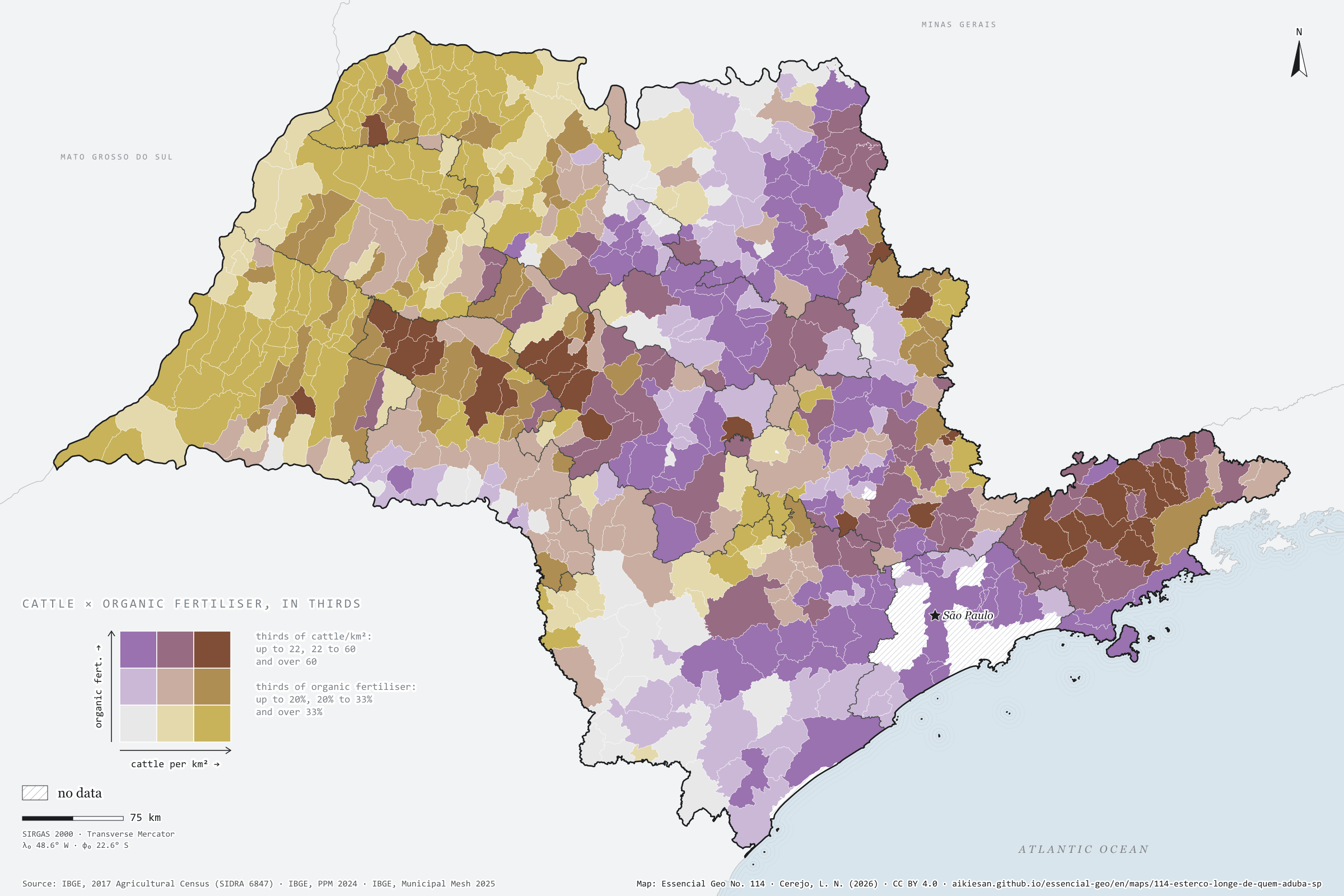
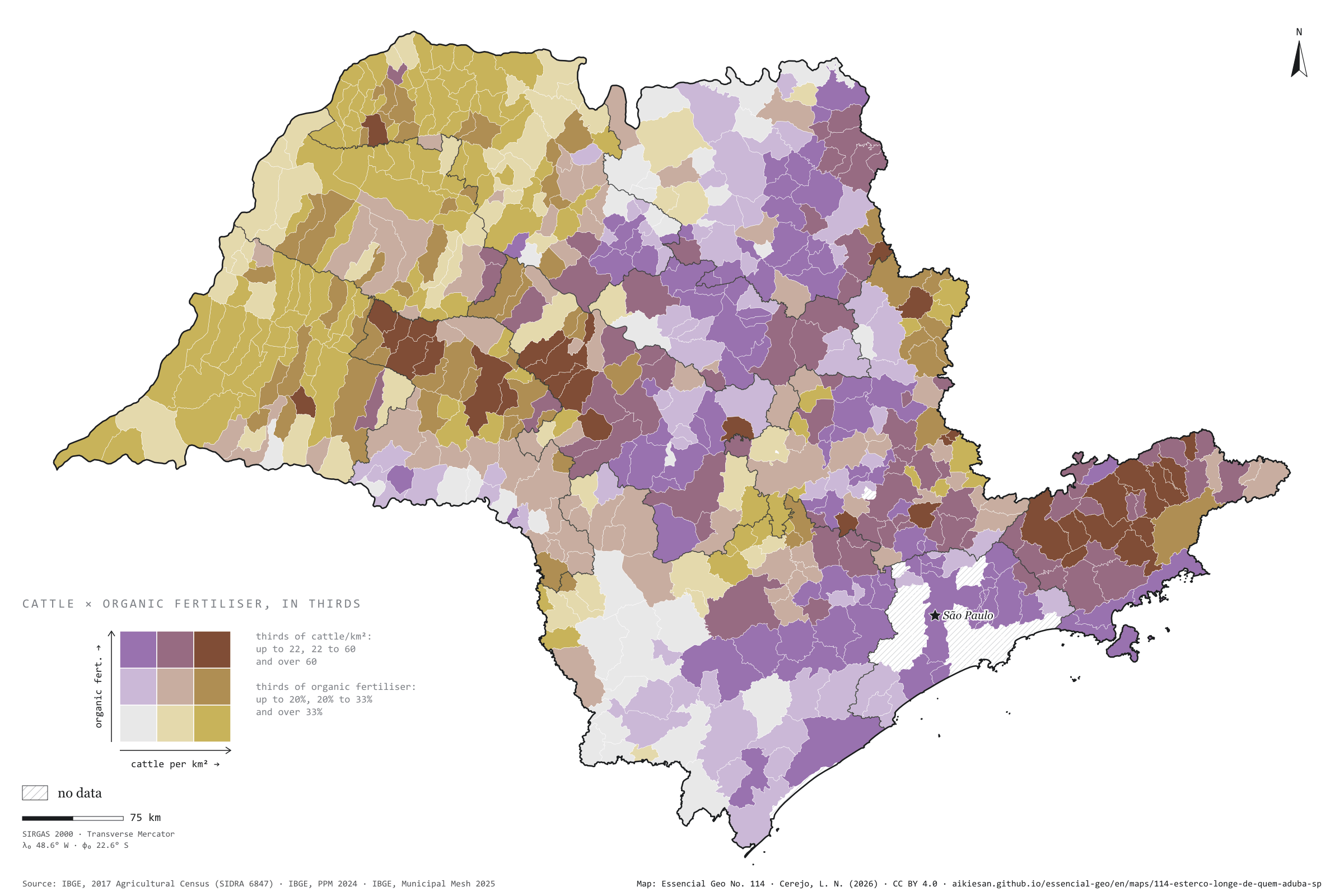
Record, downloads and citationWhere there are more cattle per km², fewer farm holdings use organic fertiliser. Across the 617 São Paulo municipalities with data, the rank correlation between the 2024 cattle herd and the share of holdings that applied organic fertiliser in the 2017 Agricultural Census is −0.41, and −0.32 net of urbanisation, density and income. In the quarter of municipalities with fewest cattle, the median is 32%; in the quarter with most, 18%. Grazing cattle leave their manure on pasture, and organic fertiliser includes compost from market gardens near towns: Ferraz de Vasconcelos, with 2.2 cattle per km², has 81%; Presidente Bernardes, with 202, 16%. Fourth plate of the collection “Bioenergy, crossed”.
Technical record · downloads · citation
At a glance
-0.4
18 %
136 municipalities
Layers
- municipios polygon 645 municipalities with the variables of all five plates, the bivariate classes and the LISA clusters (same GPKG as plates 111 to 115)
- gasodutos line Gas transmission pipelines and distribution network (EPE)
- regioes_intermediarias polygon 11 intermediate geographic regions
- limite_estadual polygon State boundary
Metadata
- Sources
- IBGE — Municipal Livestock Survey (PPM) 2024, table 3939: herd size (2024)
IBGE — 2017 Agricultural Census, SIDRA table 6847 (holdings by use of fertiliser) (2017)
IBGE — 2022 Population Census (population, urbanisation and income by municipality) (2022)
IBGE — Municipal Mesh 2025 (2025) - Extent
- São Paulo State (SP)
- CRS / Projection
- SIRGAS 2000 (EPSG:4674)
EPSG:4674 - Software
- Node.js · d3-geo · QGIS
- Method
- Cattle per km² (IBGE, PPM 2024) and share of farm holdings that applied organic fertiliser, alone or with chemical (IBGE, 2017 Agricultural Census), each in thirds of municipalities, crossed in a 3 × 3 bivariate map; Spearman rank correlations, raw and partial, and bivariate LISA.
- Version
- v1.0.0
- Licence
- CC BY 4.0
- DOI
- being registered on Zenodo
Downloads
- GPKG Municipalities and pipelines with the variables of all five plates, SIRGAS 2000, with QGIS styles (.gpkg) 4.7 MB
- CSV Municipal table (the same on all five plates) (.csv) 120 kB
- SVG Vector plate, for printing (.svg) 2.2 MB
- PNG Plate (PNG, 2400 px) (.png) 0.3 MB

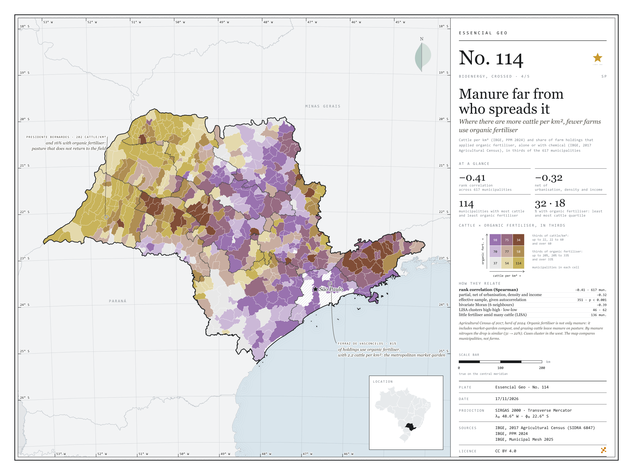
Figure to reuse
The map without a frame, with legend, scale, reference system and credit written on it: ready for papers, lectures and slides. In two versions: with the basemap (neighbours and sea) or only the mapped area, on white.
With basemap (PNG) Without basemap (PNG) QR code (SVG)
Point a camera at it to open this page.
How to cite
CEREJO, Lucas Nakamura. O esterco longe de quem aduba: onde há mais boi por km², menos estabelecimentos usam adubo orgânico. Versão 1.0.0. [S. l.]: Essencial, 2026. Conjunto de dados. Disponível em: https://aikiesan.github.io/essencial-geo/en/maps/114-esterco-longe-de-quem-aduba-sp/. Acesso em: 10 nov. 2026.
Cerejo, L. N. (2026). O esterco longe de quem aduba: onde há mais boi por km², menos estabelecimentos usam adubo orgânico [Manure far from who spreads it: Where there are more cattle per km², fewer farms use organic fertiliser] (Version 1.0.0) [Data set]. Essencial. https://aikiesan.github.io/essencial-geo/en/maps/114-esterco-longe-de-quem-aduba-sp/
@dataset{cerejo2026_esterco_longe_de_quem_aduba_sp,
  author    = {Cerejo, Lucas Nakamura},
  title     = {O esterco longe de quem aduba: Onde há mais boi por km², menos estabelecimentos usam adubo orgânico},
  year      = {2026},
  publisher = {Essencial},
  version   = {1.0.0},
  url       = {https://aikiesan.github.io/essencial-geo/en/maps/114-esterco-longe-de-quem-aduba-sp/},
  language  = {portuguese},
  note      = {English title: Manure far from who spreads it: Where there are more cattle per km², fewer farms use organic fertiliser. Licence CC BY 4.0}
}