Skip to content
Essencial

No. 115 Energy · biomass Bioenergy, crossed 5/5

Small, gas-rich and on their own

48 towns of under 20,000 people hold 21% of the biomethane potential and lie far from the pipeline

Record, downloads and citation
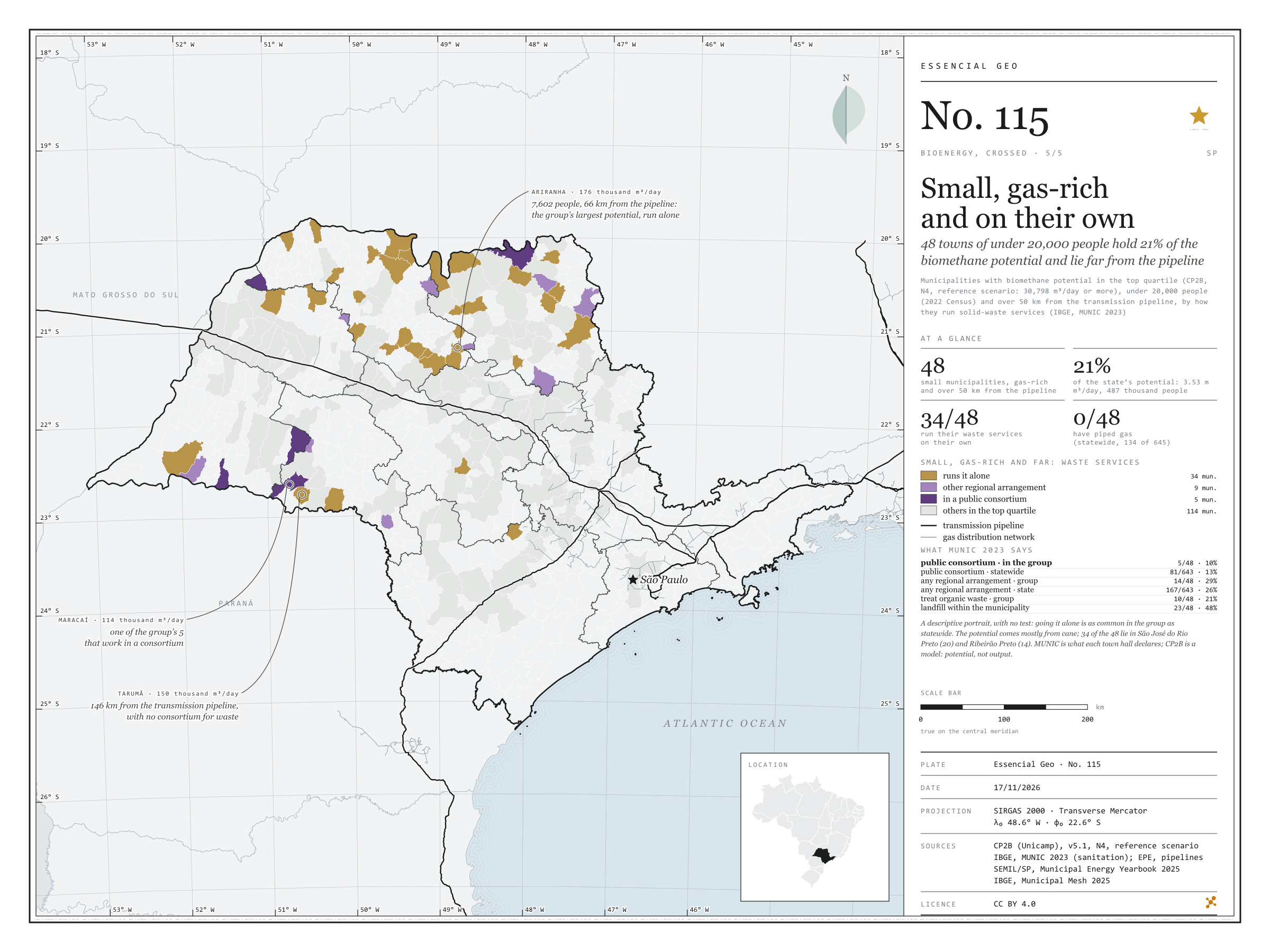
Fig. 115 São Paulo State (SP) EPSG:4674 Source: CP2B (Unicamp), IBGE, EPE, SEMIL/SP, Municipal Energy Yearbook 2025 (base year 2024): sales of hydrous ethanol, petrol C, diesel oil and piped natural gas by municipality

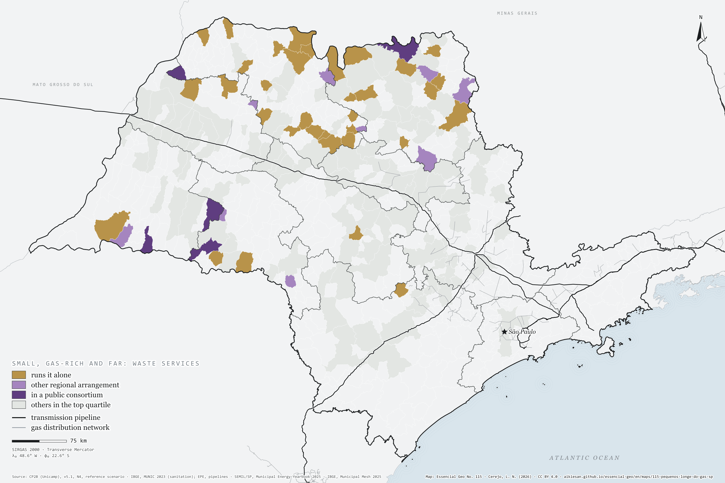
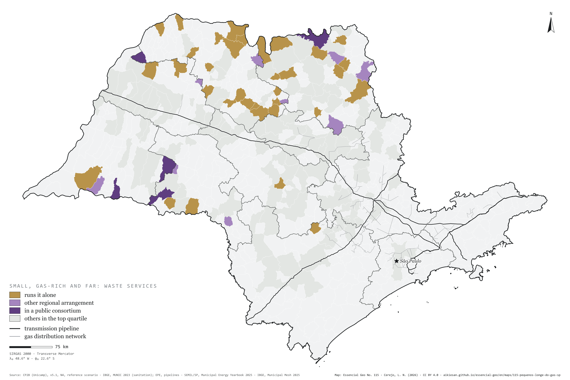
48 São Paulo municipalities combine three things: biomethane potential in the state’s top quarter, fewer than 20,000 people and over 50 km from the transmission pipeline. Together they hold 21% of the state’s accessible potential, 3.53 million m³ a day, for 487 thousand people, mostly from cane. According to MUNIC 2023, 34 of them run solid-waste services on their own, 9 have another regional arrangement and 5 are in a public consortium; none uses piped gas. Going it alone is as common in the group as statewide: this is a descriptive portrait, with no test. Ariranha, with 7,602 people, has the group’s largest potential, 176 thousand m³/day. Fifth plate of the collection “Bioenergy, crossed”.

Technical record · downloads · citation

At a glance

Small, high-potential municipalities far from the pipeline

48 municipalities

of 162 in the top quarter of potential

Share of the state’s accessible potential

21 %

3.53 million m³/day

Run waste services on their own

34 municipalities

of 48; 5 in a public consortium

Layers

  • municipios polygon 645 municipalities with the variables of all five plates, the bivariate classes and the LISA clusters (same GPKG as plates 111 to 115)
  • gasodutos line Gas transmission pipelines and distribution network (EPE)
  • regioes_intermediarias polygon 11 intermediate geographic regions
  • limite_estadual polygon State boundary

Metadata

Sources
CP2B (Unicamp) — biogas and biomethane potential by municipality, method v5.1, level N4, reference scenario (2026)
IBGE — Survey of Basic Municipal Information (MUNIC) 2023, sanitation supplement: solid waste management (2023)
EPE — WebMap: existing transmission and distribution gas pipelines, as published in the MapBiomas infrastructure database (2022)
SEMIL/SP, Municipal Energy Yearbook 2025 (base year 2024): sales of hydrous ethanol, petrol C, diesel oil and piped natural gas by municipality (2025)
IBGE — 2022 Population Census (population, urbanisation and income by municipality) (2022)
IBGE — Municipal Mesh 2025 (2025)
Extent
São Paulo State (SP)
CRS / Projection
SIRGAS 2000 (EPSG:4674)
EPSG:4674
Software
Node.js · d3-geo · QGIS
Method
Municipalities with CP2B biomethane potential (v5.1, N4, reference scenario) in the state’s top quarter (30,798 m³/day or more), fewer than 20,000 people (2022 Census) and over 50 km in a straight line from the transmission pipeline (EPE), classified by how they run solid-waste management as declared in MUNIC 2023; no statistical test.
Version
v1.0.0
Licence
CC BY 4.0
DOI
being registered on Zenodo

Downloads

Figure to reuse

The map without a frame, with legend, scale, reference system and credit written on it: ready for papers, lectures and slides. In two versions: with the basemap (neighbours and sea) or only the mapped area, on white.

Point a camera at it to open this page.

How to cite

Cerejo, L. N. (2026). Pequenos, cheios de gás e sozinhos: 48 municípios de menos de 20 mil habitantes têm 21 % do potencial de biometano e ficam longe do gasoduto [Small, gas-rich and on their own: 48 towns of under 20,000 people hold 21% of the biomethane potential and lie far from the pipeline] (Version 1.0.0) [Data set]. Essencial. https://aikiesan.github.io/essencial-geo/en/maps/115-pequenos-longe-do-gas-sp/

How to read this plate area, projection, scale, legend and source · 4 terms
1 Area
São Paulo State (SP) The area the plate covers. Outside it, neighbours and sea are drawn in grey, just for orientation.
2 Coordinates and projection
SIRGAS 2000 (EPSG:4674) The layers are in SIRGAS 2000; the drawing’s projection is written in the colophon at the foot of the panel.
3 Scale
Graphic scale bar in the panel The scale bar is true on the central meridian; away from it, measured distances vary a little.
4 Legend and layers
4 layers in the GeoPackage · polygon, line Read the legend before the map: it tells you whether a colour is a rate or a class, and whether a circle is a total.
5 Sources
CP2B (Unicamp) (2026); IBGE (2023); EPE (2022); SEMIL/SP, Municipal Energy Yearbook 2025 (base year 2024): sales of hydrous ethanol, petrol C, diesel oil and piped natural gas by municipality (2025); IBGE (2022); IBGE (2025) Every figure comes from a public source, with its year. The data sheet gives each one’s address.

Terms on this plate

Biomethane
Biogas upgraded, with most of the CO₂ removed, to ANP’s specification, at which point it replaces natural gas in the pipeline, in industry and in the lorry’s tank.
N1 to N4 (potential levels)
CP2B’s four levels: N1 theoretical (all residue generated), N2 technical (after collection), N3 mobilisable (after competing uses and what already becomes biogas) and N4 accessible (after storage and the logistic factor).
2022 Census
IBGE’s door-to-door count. Results by census tract give residents, age, household-head income, water, sewerage and rubbish.
MUNIC
IBGE’s Survey of Basic Municipal Information: a questionnaire answered by the town halls themselves on how they govern, rubbish included.

Download

Layers, table and figures, under CC BY 4.0. Cite with the DOI.

Full record and citation

Method notes · No. 115

Small municipalities with high biomethane potential, far from the pipeline, by how they run waste services

Português · English

Plate No. 115, the fifth of five in the collection Bioenergy, crossed; the previous one is plate 114.

The collection crosses São Paulo’s bioenergy with what filling stations sell, with the countryside and with town halls, across the state’s 645 municipalities. The pairs came from a correlation screen between CP2B biomethane potential, fuel sales in the SEMIL Yearbook, plantation forestry, the cattle herd, the Agricultural Census, the vehicle fleet and MUNIC. Each pair went through raw and partial rank correlation (net of urbanisation, density and income), an effective sample corrected for spatial autocorrelation, Benjamini–Hochberg q values and bivariate LISA. The last plate is descriptive, with no test, and the text says so.

The map’s callouts point to Ariranha, with 176 thousand m³/day, 7,602 people and 66 km from the pipeline, the group’s largest potential, which runs its services alone; Tarumã, with 150 thousand m³/day 146 km from the transmission pipeline, also alone; and Maracaí, with 114 thousand m³/day, one of the group’s 5 in a public consortium.

What the files contain

Layer (GPKG)GeometryContent
municipiospolygon645 municipalities with cane and ethanol, biomethane and diesel, the fleet, native cover and pulpwood, cattle and organic fertiliser, distances to the pipeline, piped gas and the MUNIC answers on waste; classes b111, b113, b114, arranjo115 and clusters lisa111, lisa113, lisa114
gasodutoslinetransmission pipelines and distribution network (tipo)
regioes_intermediarias, limite_estadualpolygonreference

The GPKG is the same for all five plates and carries a QGIS style for each. The CSV has the municipal table, without geometry. Empty fields are missing data, not zero. LISA clusters come as AA (high-high), BB (low-low), AB, BA and ns (not significant); the first letter is the municipality’s variable, the second its neighbours’.

Method

  1. cheio115: biomethane potential (biometano_m3d, CP2B v5.1, N4, reference) in the top quarter of the 645 municipalities, 30,798 m³/day or more (162 municipalities). alvo115: in addition, fewer than 20,000 people in the 2022 Census (pessoas) and km_gasoduto_transporte above 50 km.
  2. km_gasoduto_transporte and km_gasoduto_distribuicao: straight-line distance from the municipality’s interior point to the nearest transmission pipeline and distribution network (EPE, in the MapBiomas infrastructure database; plate 057).
  3. arranjo115 (group only): consorcio when MUNIC 2023 says solid-waste services are run regionally through a public consortium; regional for another regional arrangement; sozinho when they are not regionalised; sem_informacao when the town hall did not answer (no cases). rs_consorcio, rs_regionalizado, rs_trat_organicos, rs_compostagem, rs_aterro_sanitario and rs_coleta_seletiva carry every municipality’s answers (1 yes, 0 no).
  4. In the group and statewide (643 municipalities answered MUNIC): public consortium 5 of 48 (10%) against 81 of 643 (13%); any regional arrangement 14 of 48 (29%) against 167 of 643 (26%); treat organic waste 10 of 48 (21%) against 91 of 643 (14%); composting 5 of 48 (10%); sanitary landfill in the municipality 23 of 48 (48%); separate collection 38 of 48 (79%).
  5. tem_gas_canalizado: piped natural gas consumption in the SEMIL Yearbook (2024). In the group, 0 of 48; statewide, 134 of 645. By intermediate region, the group lies in São José do Rio Preto (20), Ribeirão Preto (14), Marília (5), Presidente Prudente (4) and Araçatuba (3).

Limitations

  • CP2B is a model: the potential estimates what residues would yield at level N4 (accessible, after collection, competing uses, storage and haulage), not biomethane actually produced.
  • The group’s potential comes mostly from cane, whose residues depend on the mill, not the town hall: the municipal waste service is only one of the doors to a biogas project. The map does not say a consortium would make the biogas happen.
  • The cut-offs (top quarter, 20,000 people, 50 km) are reading choices; other cut-offs change the list. Distances are straight-line, not by road. MUNIC is what each town hall declares.

View this map’s folder on GitHub

Technical record

Technical record · No. 115

Small, gas-rich and on their own

At a glance

Small, high-potential municipalities far from the pipeline

48 municipalities

of 162 in the top quarter of potential

Share of the state’s accessible potential

21 %

3.53 million m³/day

Run waste services on their own

34 municipalities

of 48; 5 in a public consortium

Layers

  • municipios polygon 645 municipalities with the variables of all five plates, the bivariate classes and the LISA clusters (same GPKG as plates 111 to 115)
  • gasodutos line Gas transmission pipelines and distribution network (EPE)
  • regioes_intermediarias polygon 11 intermediate geographic regions
  • limite_estadual polygon State boundary

Metadata

Sources
CP2B (Unicamp) — biogas and biomethane potential by municipality, method v5.1, level N4, reference scenario (2026)
IBGE — Survey of Basic Municipal Information (MUNIC) 2023, sanitation supplement: solid waste management (2023)
EPE — WebMap: existing transmission and distribution gas pipelines, as published in the MapBiomas infrastructure database (2022)
SEMIL/SP, Municipal Energy Yearbook 2025 (base year 2024): sales of hydrous ethanol, petrol C, diesel oil and piped natural gas by municipality (2025)
IBGE — 2022 Population Census (population, urbanisation and income by municipality) (2022)
IBGE — Municipal Mesh 2025 (2025)
Extent
São Paulo State (SP)
CRS / Projection
SIRGAS 2000 (EPSG:4674)
EPSG:4674
Software
Node.js · d3-geo · QGIS
Method
Municipalities with CP2B biomethane potential (v5.1, N4, reference scenario) in the state’s top quarter (30,798 m³/day or more), fewer than 20,000 people (2022 Census) and over 50 km in a straight line from the transmission pipeline (EPE), classified by how they run solid-waste management as declared in MUNIC 2023; no statistical test.
Version
v1.0.0
Licence
CC BY 4.0
DOI
being registered on Zenodo

Downloads

Figure to reuse

The map without a frame, with legend, scale, reference system and credit written on it: ready for papers, lectures and slides. In two versions: with the basemap (neighbours and sea) or only the mapped area, on white.

Point a camera at it to open this page.

How to cite

Cerejo, L. N. (2026). Pequenos, cheios de gás e sozinhos: 48 municípios de menos de 20 mil habitantes têm 21 % do potencial de biometano e ficam longe do gasoduto [Small, gas-rich and on their own: 48 towns of under 20,000 people hold 21% of the biomethane potential and lie far from the pipeline] (Version 1.0.0) [Data set]. Essencial. https://aikiesan.github.io/essencial-geo/en/maps/115-pequenos-longe-do-gas-sp/

100%