Eucalyptus against the forest
Where more native vegetation remains, more wood goes to paper and pulp
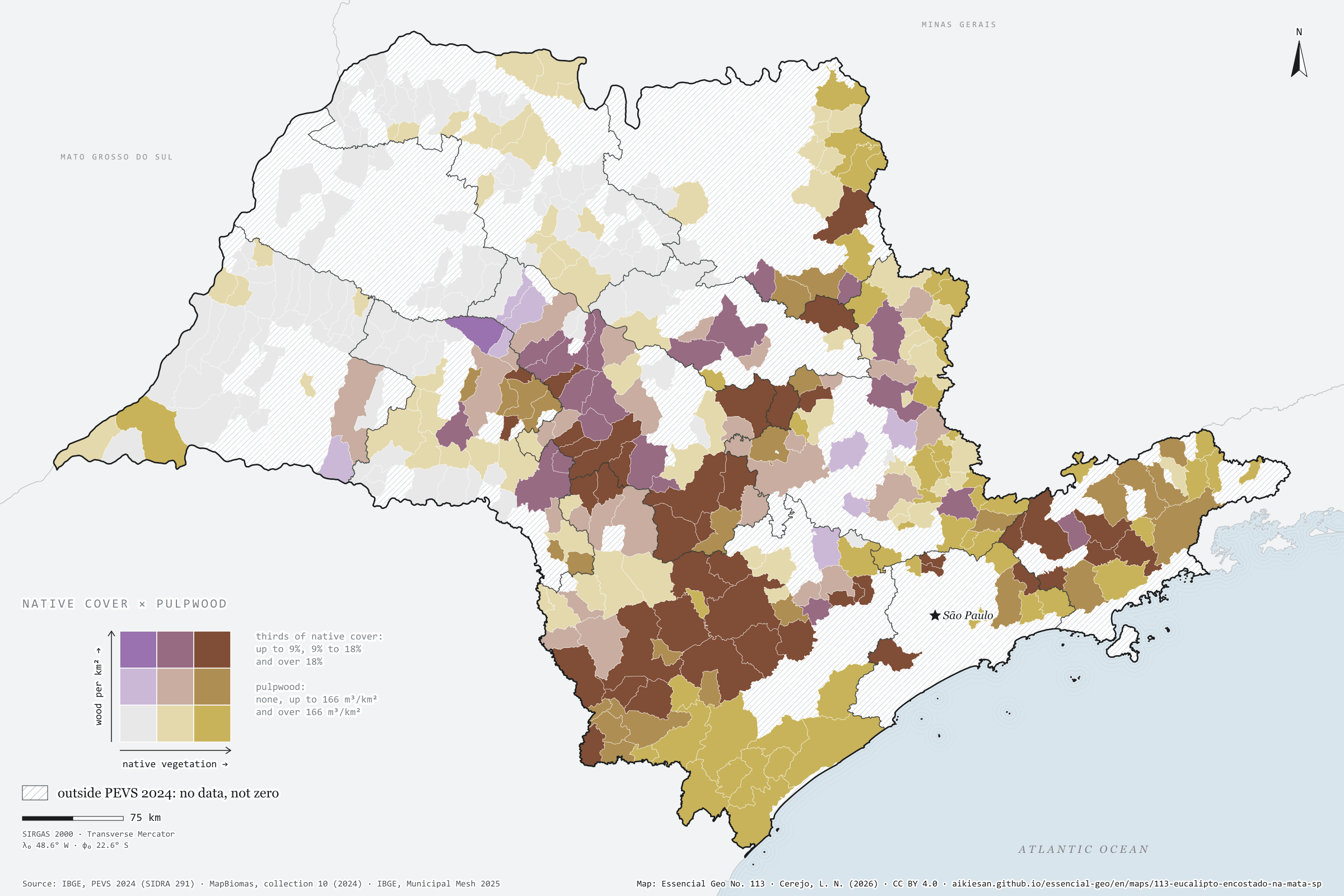
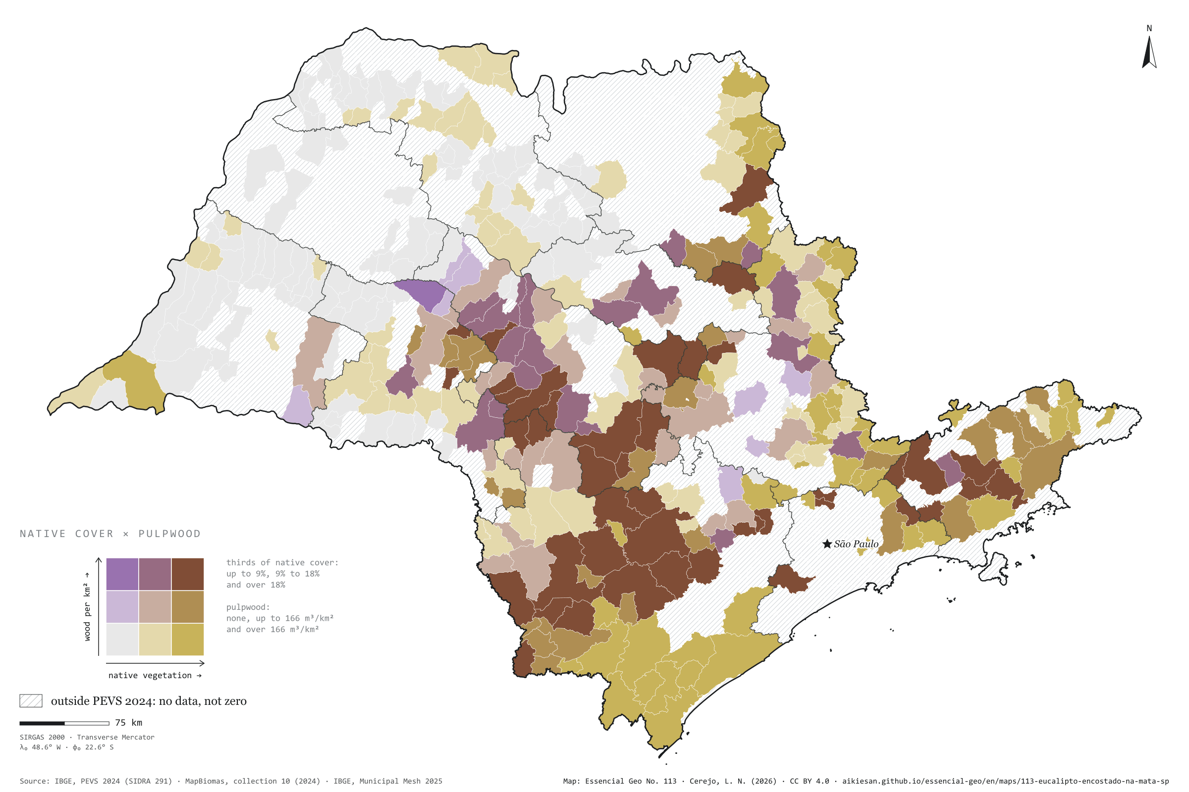
Record, downloads and citationIn São Paulo municipalities that harvest plantation wood for paper and pulp, the more native vegetation remains, the more wood comes out per km². Across the 366 municipalities in PEVS 2024, the rank correlation is 0.42, and 0.47 net of urbanisation, density and income. The median producer has 18.7% of its area under native vegetation; surveyed municipalities that do not produce, 9.8%. The 127 producers harvested 24.8 million m³, mostly in the south-west, around Sorocaba, and the centre-west, around Bauru. Capão Bonito combines 39% native cover with 1.70 million m³. Relief and soils that keep cane away may lie behind both. Third plate of the collection “Bioenergy, crossed”.
Technical record · downloads · citation
At a glance
0.4
19 %
25 million m³
Layers
- municipios polygon 645 municipalities with the variables of all five plates, the bivariate classes and the LISA clusters (same GPKG as plates 111 to 115)
- gasodutos line Gas transmission pipelines and distribution network (EPE)
- regioes_intermediarias polygon 11 intermediate geographic regions
- limite_estadual polygon State boundary
Metadata
- Sources
- IBGE — Forestry and Plant Extraction Survey (PEVS) 2024, SIDRA table 291 (roundwood for paper and pulp) (2024)
MapBiomas — Land cover and land use Collection 10 (2024) (2024)
IBGE — 2022 Population Census (population, urbanisation and income by municipality) (2022)
IBGE — Municipal Mesh 2025 (2025) - Extent
- São Paulo State (SP)
- CRS / Projection
- SIRGAS 2000 (EPSG:4674)
EPSG:4674 - Software
- Node.js · d3-geo · QGIS
- Method
- Share of municipal area under native vegetation (MapBiomas, collection 10, 2024), in thirds, crossed with plantation roundwood for paper and pulp per km² (IBGE, PEVS 2024): none, below and above the producers’ median; 3 × 3 bivariate map only in PEVS municipalities; Spearman rank correlations, raw and partial, and bivariate LISA.
- Version
- v1.0.0
- Licence
- CC BY 4.0
- DOI
- being registered on Zenodo
Downloads
- GPKG Municipalities and pipelines with the variables of all five plates, SIRGAS 2000, with QGIS styles (.gpkg) 4.7 MB
- CSV Municipal table (the same on all five plates) (.csv) 120 kB
- SVG Vector plate, for printing (.svg) 2.2 MB
- PNG Plate (PNG, 2400 px) (.png) 0.3 MB

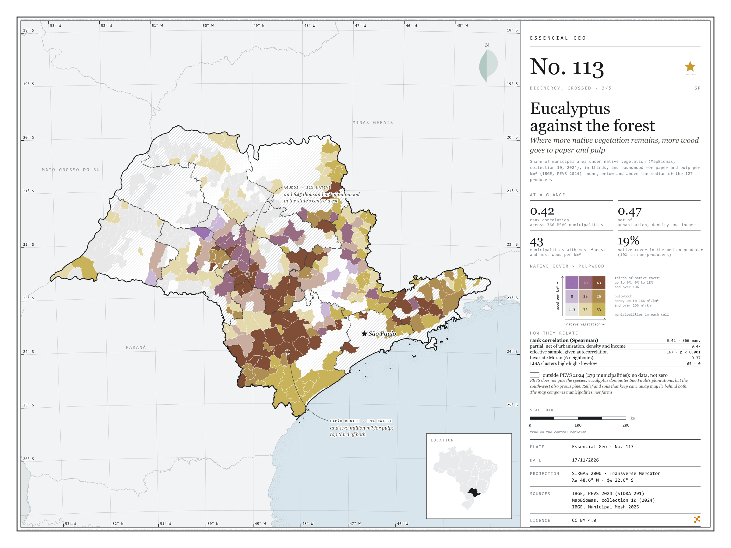
Figure to reuse
The map without a frame, with legend, scale, reference system and credit written on it: ready for papers, lectures and slides. In two versions: with the basemap (neighbours and sea) or only the mapped area, on white.
With basemap (PNG) Without basemap (PNG) QR code (SVG)
Point a camera at it to open this page.
How to cite
CEREJO, Lucas Nakamura. Eucalipto encostado na mata: onde sobra mais vegetação nativa, mais madeira sai para o papel e a celulose. Versão 1.0.0. [S. l.]: Essencial, 2026. Conjunto de dados. Disponível em: https://aikiesan.github.io/essencial-geo/en/maps/113-eucalipto-encostado-na-mata-sp/. Acesso em: 10 nov. 2026.
Cerejo, L. N. (2026). Eucalipto encostado na mata: onde sobra mais vegetação nativa, mais madeira sai para o papel e a celulose [Eucalyptus against the forest: Where more native vegetation remains, more wood goes to paper and pulp] (Version 1.0.0) [Data set]. Essencial. https://aikiesan.github.io/essencial-geo/en/maps/113-eucalipto-encostado-na-mata-sp/
@dataset{cerejo2026_eucalipto_encostado_na_mata_sp,
  author    = {Cerejo, Lucas Nakamura},
  title     = {Eucalipto encostado na mata: Onde sobra mais vegetação nativa, mais madeira sai para o papel e a celulose},
  year      = {2026},
  publisher = {Essencial},
  version   = {1.0.0},
  url       = {https://aikiesan.github.io/essencial-geo/en/maps/113-eucalipto-encostado-na-mata-sp/},
  language  = {portuguese},
  note      = {English title: Eucalyptus against the forest: Where more native vegetation remains, more wood goes to paper and pulp. Licence CC BY 4.0}
}