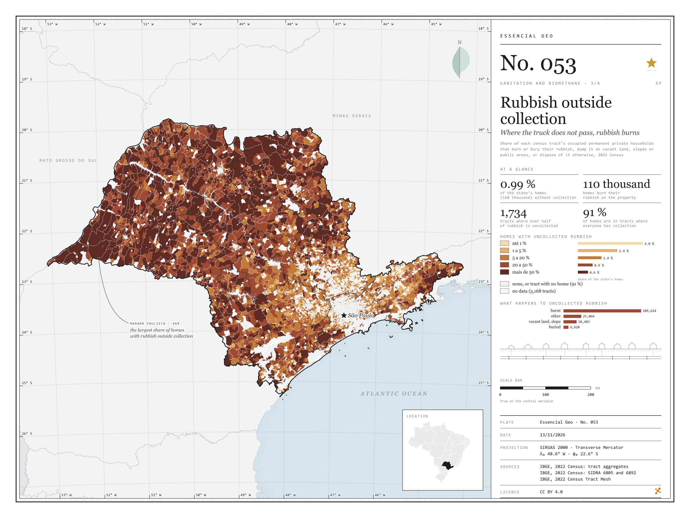
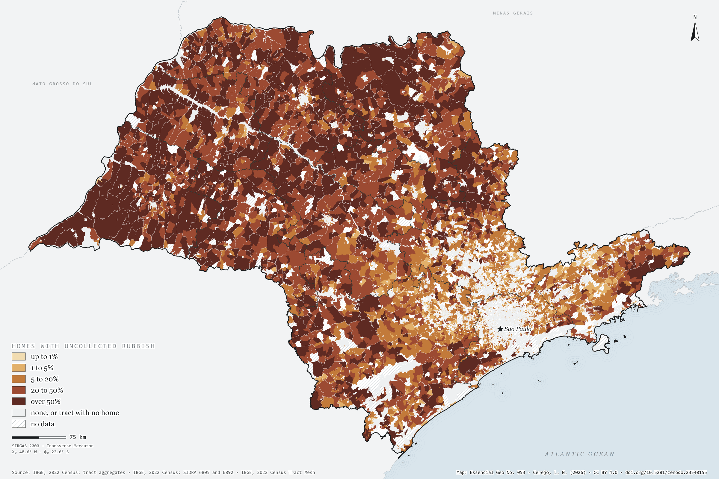
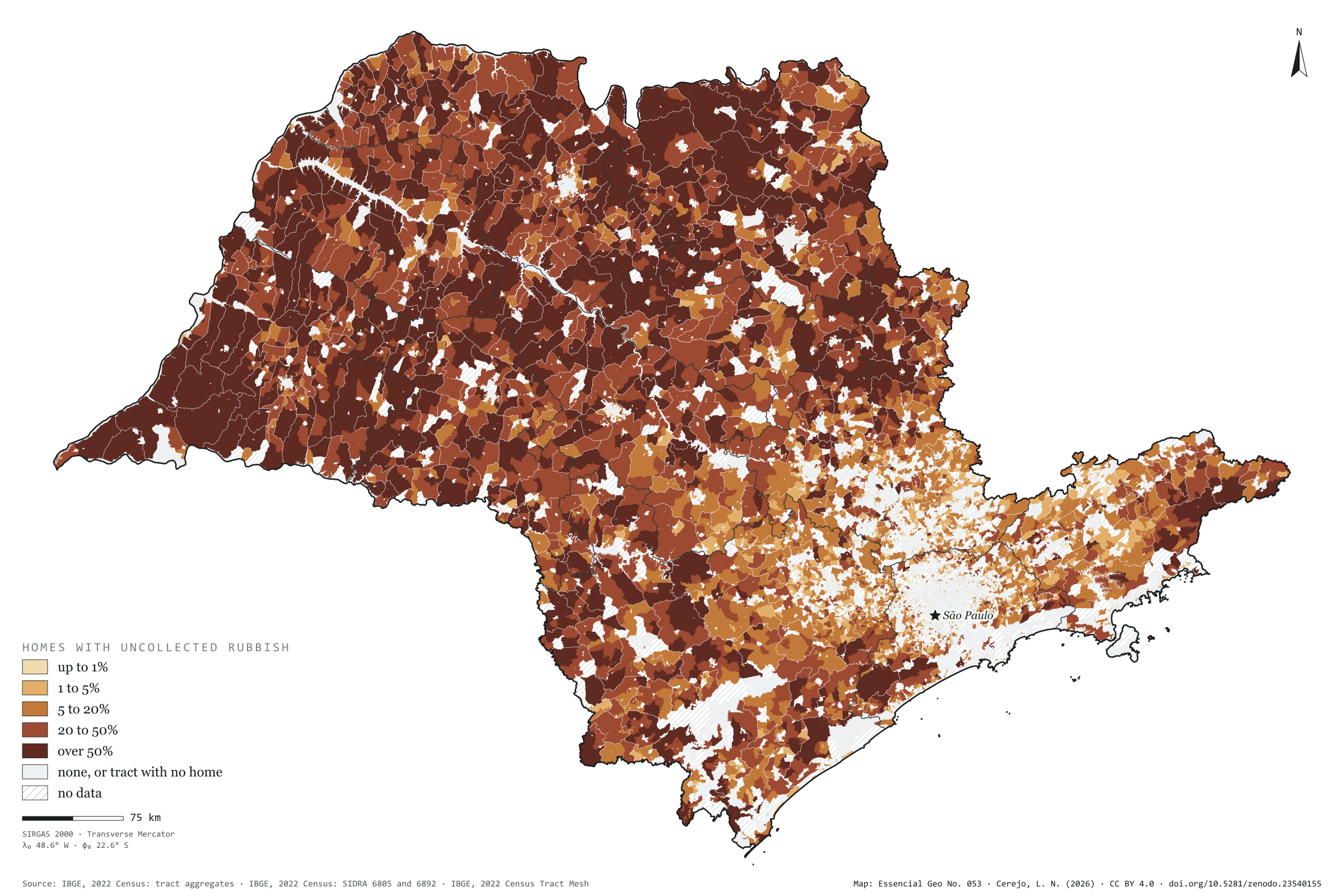
Nearly all of São Paulo’s rubbish is collected: in 2022, only 0.99% of households, 160,000, disposed of it otherwise. But that 1% is not spread out. It is in the countryside, where the truck does not reach, and the most common destination is fire: 110,000 households burnt their rubbish on the property. Painted tract by tract, the map shows the state inside out: the towns are pale, with collection for everyone, and the rural interior darkens. In 1,734 tracts, more than half the households had no collection. Marabá Paulista, in the Pontal do Paranapanema, has the largest share of its households outside collection (46%); the capital has the largest number (12,094). Rubbish that is not collected does not reach a landfill or a digester either. Third plate of the collection “Sanitation and biomethane”.
Technical record · downloads · citation
At a glance
Households, by the share of their tract with uncollected rubbish (households)
none90.7%
up to 1%4%
1 to 5%2.4%
5 to 20%1.4%
20 to 50%0.9%
over 50%0.6%
Households with uncollected rubbish
1%
160,093 of 16,224,248 (SIDRA 6892)
Households burning rubbish on the property
109,624households
Layers
setorespolygon103,319 census tracts: households by rubbish destination and uncollected-rubbish class (same GPKG as plate 051)
regioes_intermediariaspolygon11 intermediate geographic regions
Share of each census tract’s occupied permanent private households that burn or bury their rubbish, dump it on vacant land, slopes or public areas, or dispose of it otherwise, in five classes and zero; tracts with withheld values get a class only when it does not depend on the omitted value.
The map without a frame, with legend, scale, reference system and credit written on it: ready for papers, lectures and slides. In two versions: with the basemap (neighbours and sea) or only the mapped area, on white.
CEREJO, Lucas Nakamura. Lixo fora da coleta: onde o caminhão não passa, o lixo queima. Versão 1.0.0. [S. l.]: Zenodo, 2026. Conjunto de dados. DOI: 10.5281/zenodo.23540155. Disponível em: https://doi.org/10.5281/zenodo.23540155. Acesso em: 10 nov. 2026.
Cerejo, L. N. (2026). Lixo fora da coleta: onde o caminhão não passa, o lixo queima [Rubbish outside collection: Where the truck does not pass, rubbish burns] (Version 1.0.0) [Data set]. Zenodo. https://doi.org/10.5281/zenodo.23540155
@dataset{cerejo2026_lixo_fora_da_coleta_sp,
  author    = {Cerejo, Lucas Nakamura},
  title     = {Lixo fora da coleta: Onde o caminhão não passa, o lixo queima},
  year      = {2026},
  publisher = {Zenodo},
  version   = {1.0.0},
  doi       = {10.5281/zenodo.23540155},
  url       = {https://doi.org/10.5281/zenodo.23540155},
  language  = {portuguese},
  note      = {English title: Rubbish outside collection: Where the truck does not pass, rubbish burns. Licence CC BY 4.0}
}
Mains in town, pits in the country, rivers at the edge
Fig. 052São Paulo State (SP)EPSG:4674Source: IBGE
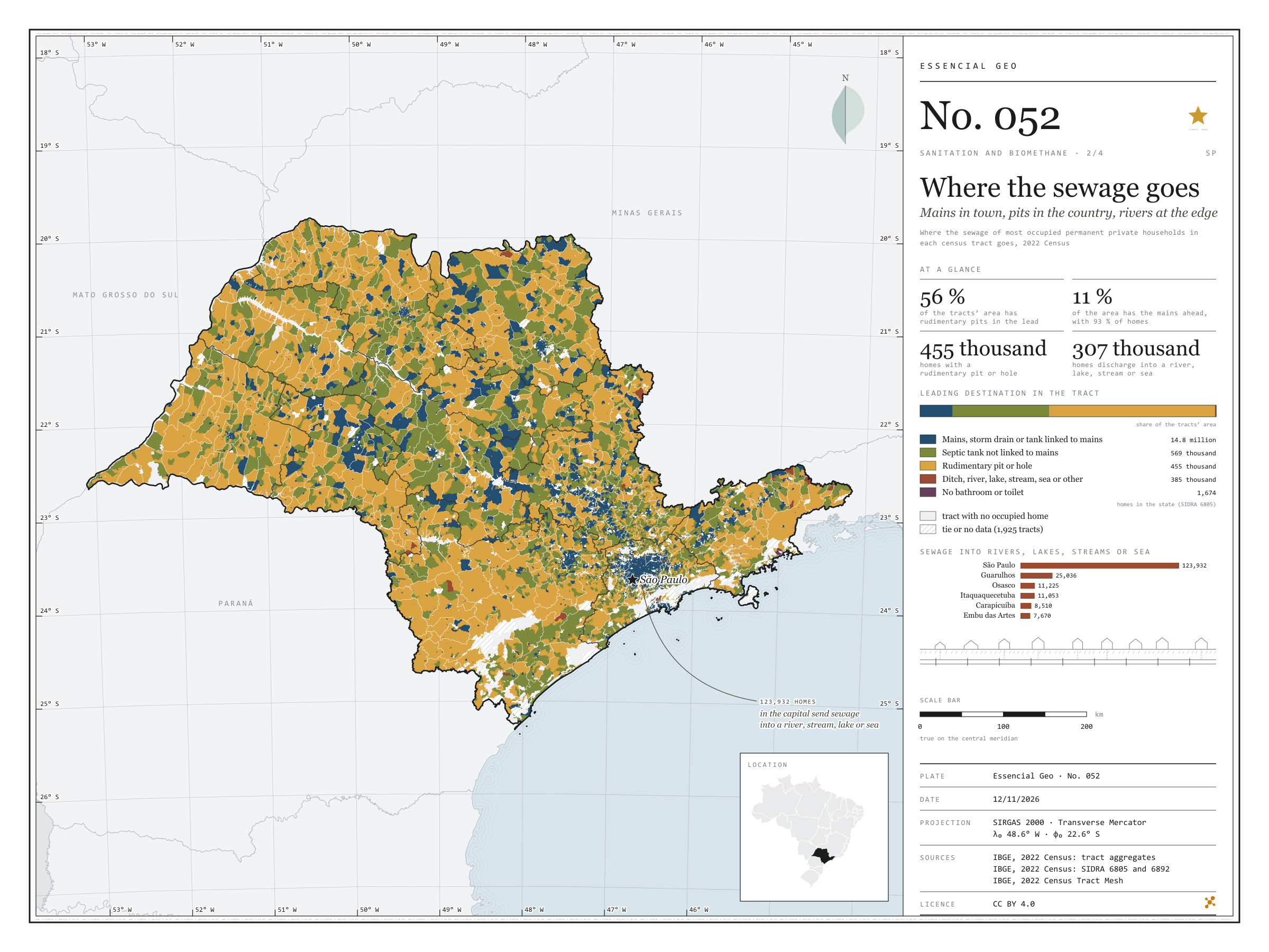
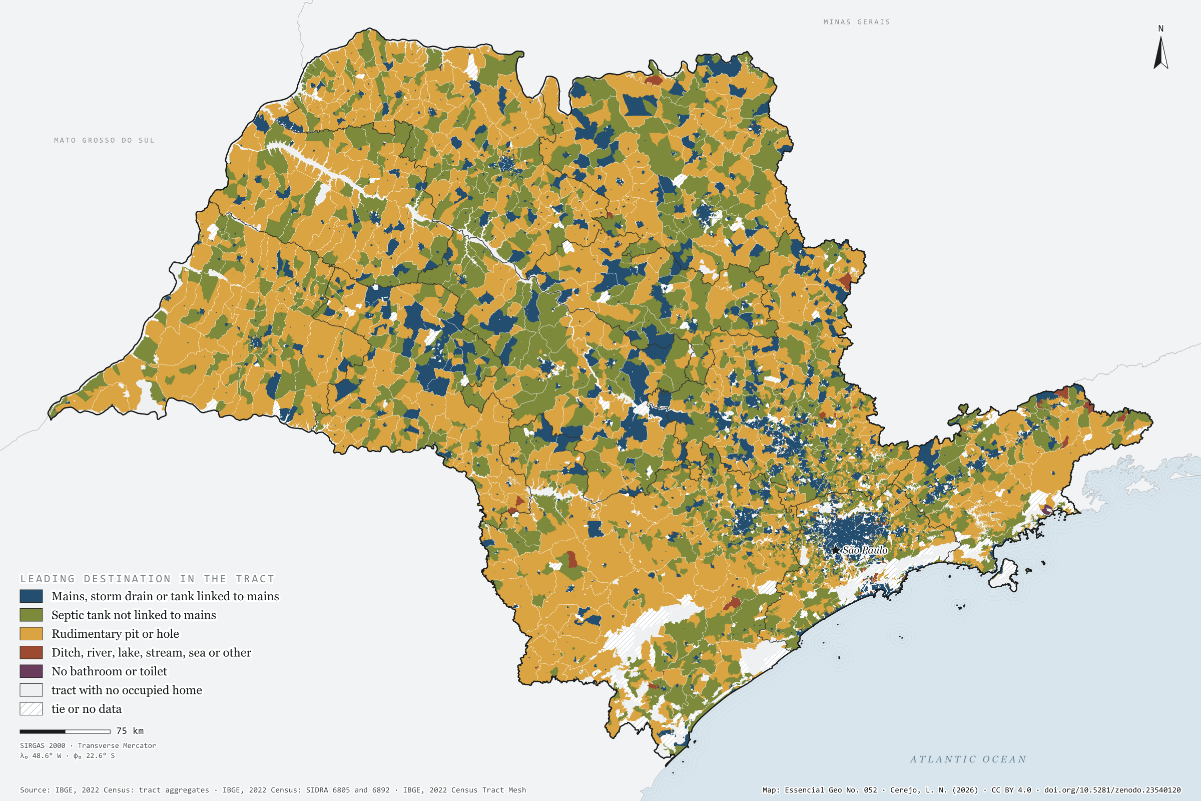
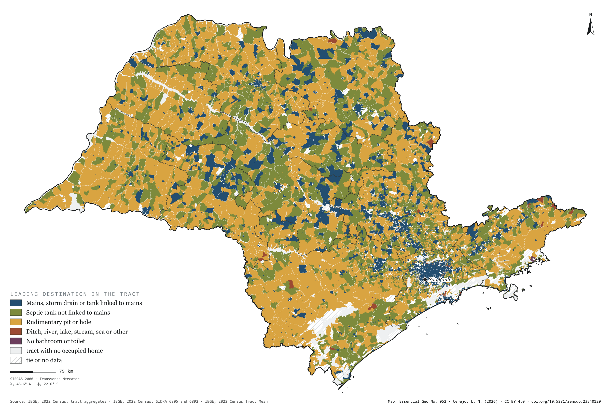
Off the mains, São Paulo’s sewage goes three ways. In 2022, 569,000 households used a septic tank, 455,000 a rudimentary pit or hole, and 385,000 discharged into a ditch, river, lake, stream, the sea or elsewhere. The map colours each census tract by where most of its households send their sewage. The mains lead in only 11% of the area, but 93% of households live there; rudimentary pits lead in 56% of the area and septic tanks in 33%, in a mosaic that covers the interior. Sewage discharged into rivers, lakes, streams or the sea is urban: of the 307,000 households doing so, 124,000 are in the capital and three quarters of the rest in the São Paulo intermediate region. Second plate of the collection “Sanitation and biomethane”.
Technical record · downloads · citation
At a glance
Households by sewage destination in the state (households)
Mains, storm drain or linked tank91.3%
Septic tank not linked3.5%
Rudimentary pit or hole2.8%
Ditch, river, lake, stream, sea or other2.4%
No bathroom or toilet0%
Tract area where rudimentary pits lead
56%
129,000 km² of 231,000 km² of tracts with a defined leader
Households in the capital discharging sewage into rivers, lakes, streams or the sea
123,932households
40% of the state’s 306,691
Layers
setorespolygon103,319 census tracts: households by sewage destination and leading destination (same GPKG as plate 051)
regioes_intermediariaspolygon11 intermediate geographic regions
Where the sewage of most occupied permanent private households in each census tract goes, in five groups; a group wins only when its minimum exceeds every other group’s maximum, counting withheld values as 1 or 2.
The map without a frame, with legend, scale, reference system and credit written on it: ready for papers, lectures and slides. In two versions: with the basemap (neighbours and sea) or only the mapped area, on white.
CEREJO, Lucas Nakamura. Para onde vai o esgoto: rede na cidade, fossa no campo, rio na beira. Versão 1.0.0. [S. l.]: Zenodo, 2026. Conjunto de dados. DOI: 10.5281/zenodo.23540120. Disponível em: https://doi.org/10.5281/zenodo.23540120. Acesso em: 10 nov. 2026.
Cerejo, L. N. (2026). Para onde vai o esgoto: rede na cidade, fossa no campo, rio na beira [Where the sewage goes: Mains in town, pits in the country, rivers at the edge] (Version 1.0.0) [Data set]. Zenodo. https://doi.org/10.5281/zenodo.23540120
@dataset{cerejo2026_destino_do_esgoto_sp,
  author    = {Cerejo, Lucas Nakamura},
  title     = {Para onde vai o esgoto: Rede na cidade, fossa no campo, rio na beira},
  year      = {2026},
  publisher = {Zenodo},
  version   = {1.0.0},
  doi       = {10.5281/zenodo.23540120},
  url       = {https://doi.org/10.5281/zenodo.23540120},
  language  = {portuguese},
  note      = {English title: Where the sewage goes: Mains in town, pits in the country, rivers at the edge. Licence CC BY 4.0}
}
The mains cover the city; the countryside stays on the tank
Fig. 051São Paulo State (SP)EPSG:4674Source: IBGE
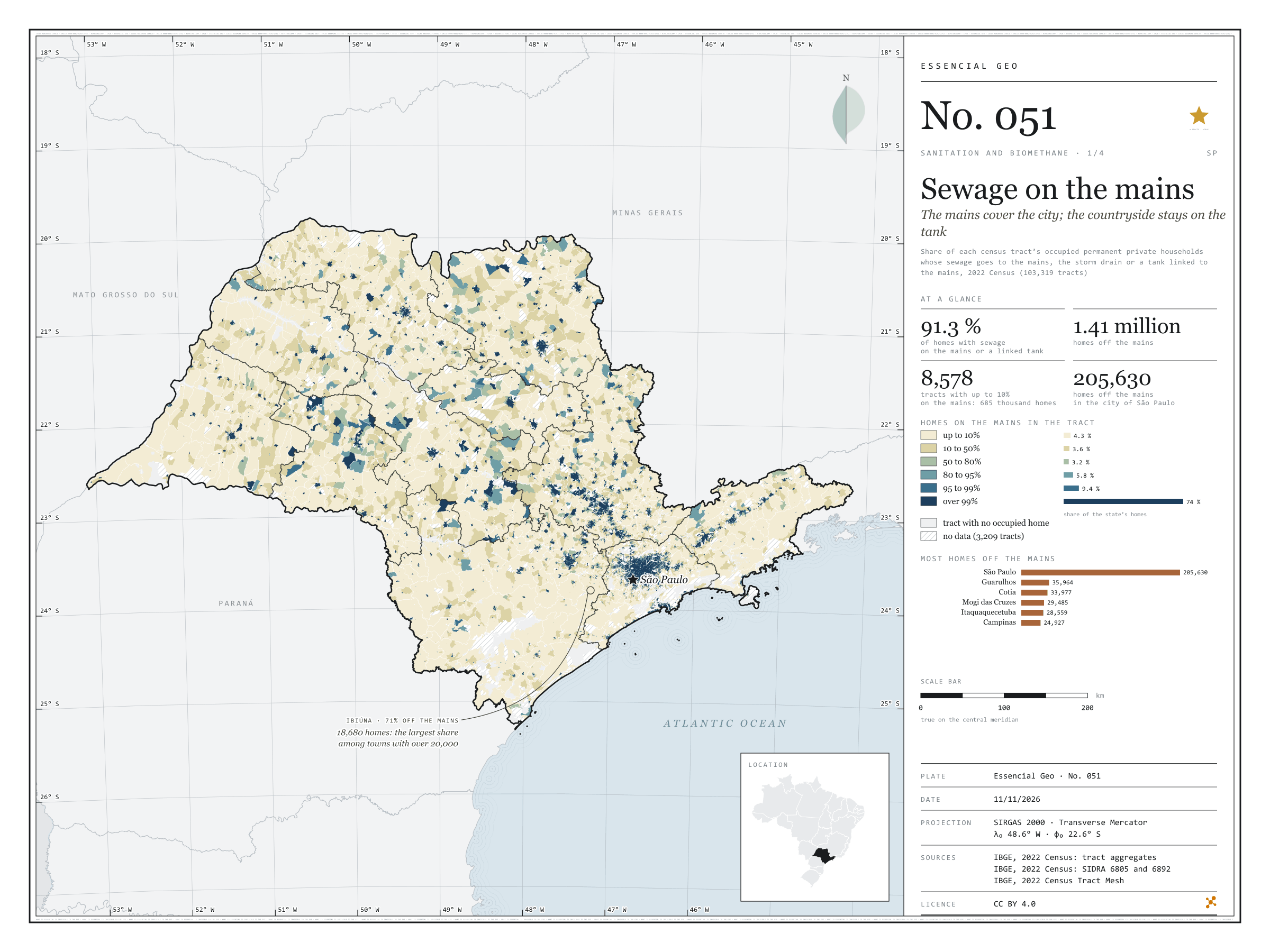
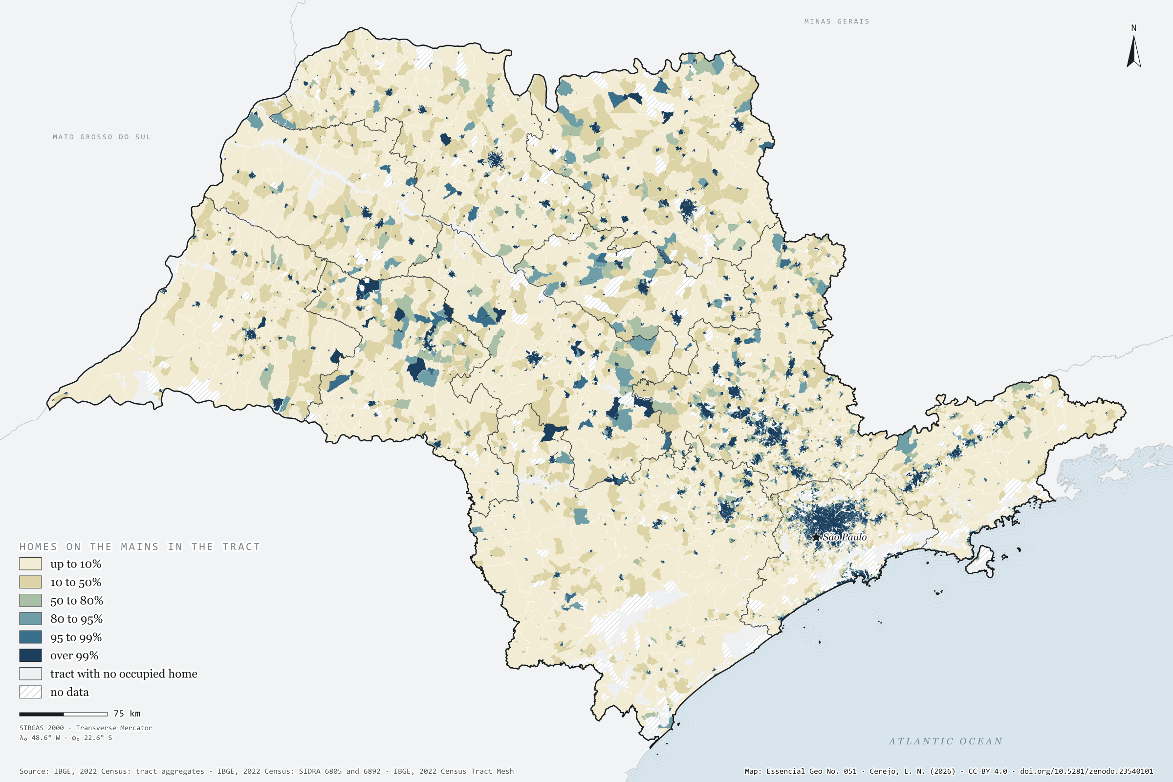
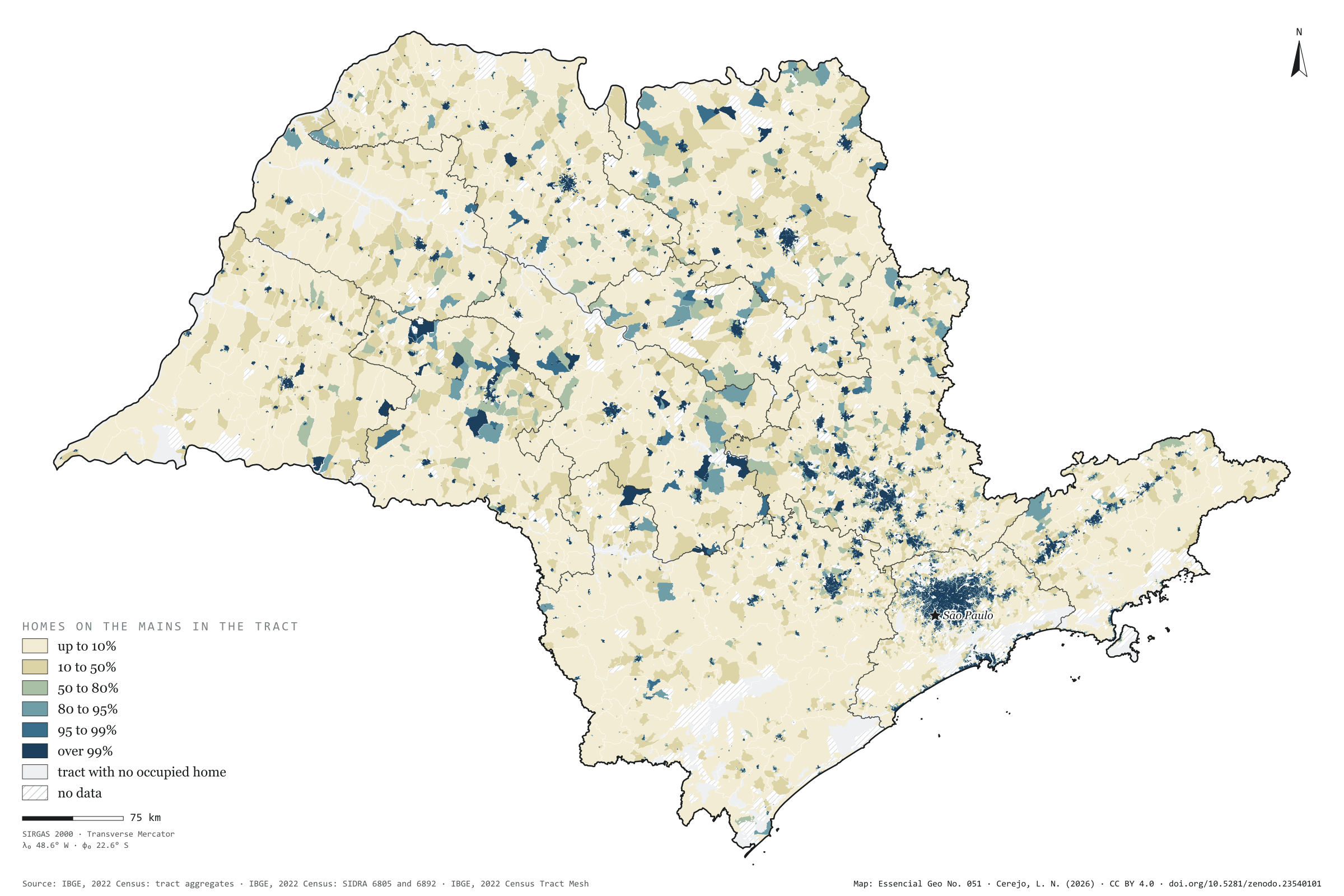
In 2022, 91.3% of households in São Paulo state had their sewage connected to the mains, to the storm drain or to a septic tank linked to the mains: 14.8 million out of 16.2 million. 1.41 million were missing. Painted tract by tract, the map shows the mains as an urban thing: three households in four live in tracts where over 99% are connected, but those tracts are small, and the cream of the rural tracts, where almost no one is on the mains, covers most of the state. The city of São Paulo has 205,630 households off the mains, the largest absolute number; among towns with more than 20,000 households, Ibiúna has the largest share off the mains (71%). First plate of the collection “Sanitation and biomethane”.
Technical record · downloads · citation
At a glance
Households, by the share of their tract connected to the sewer mains (households)
up to 10%4.3%
10 to 50%3.6%
50 to 80%3.2%
80 to 95%5.8%
95 to 99%9.4%
over 99%73.7%
Households with sewage on the mains or a tank linked to the mains
91%
14,813,509 of 16,224,248 households (SIDRA 6805)
Households off the mains in the city of São Paulo
205,630households
4.8% of the capital’s households
Layers
setorespolygon103,319 census tracts: households by sewage and rubbish destination, mains-connection class, leading destination and uncollected-rubbish class
regioes_intermediariaspolygon11 intermediate geographic regions
Share of each census tract’s occupied permanent private households whose sewage goes to the mains, the storm drain or a tank linked to the mains, in six classes; tracts with withheld values get a class only when it does not depend on the omitted value.
The map without a frame, with legend, scale, reference system and credit written on it: ready for papers, lectures and slides. In two versions: with the basemap (neighbours and sea) or only the mapped area, on white.
CEREJO, Lucas Nakamura. Esgoto na rede: a rede cobre a cidade; o campo fica na fossa. Versão 1.0.0. [S. l.]: Zenodo, 2026. Conjunto de dados. DOI: 10.5281/zenodo.23540101. Disponível em: https://doi.org/10.5281/zenodo.23540101. Acesso em: 10 nov. 2026.
Cerejo, L. N. (2026). Esgoto na rede: a rede cobre a cidade; o campo fica na fossa [Sewage on the mains: The mains cover the city; the countryside stays on the tank] (Version 1.0.0) [Data set]. Zenodo. https://doi.org/10.5281/zenodo.23540101
@dataset{cerejo2026_esgoto_na_rede_sp,
  author    = {Cerejo, Lucas Nakamura},
  title     = {Esgoto na rede: A rede cobre a cidade; o campo fica na fossa},
  year      = {2026},
  publisher = {Zenodo},
  version   = {1.0.0},
  doi       = {10.5281/zenodo.23540101},
  url       = {https://doi.org/10.5281/zenodo.23540101},
  language  = {portuguese},
  note      = {English title: Sewage on the mains: The mains cover the city; the countryside stays on the tank. Licence CC BY 4.0}
}
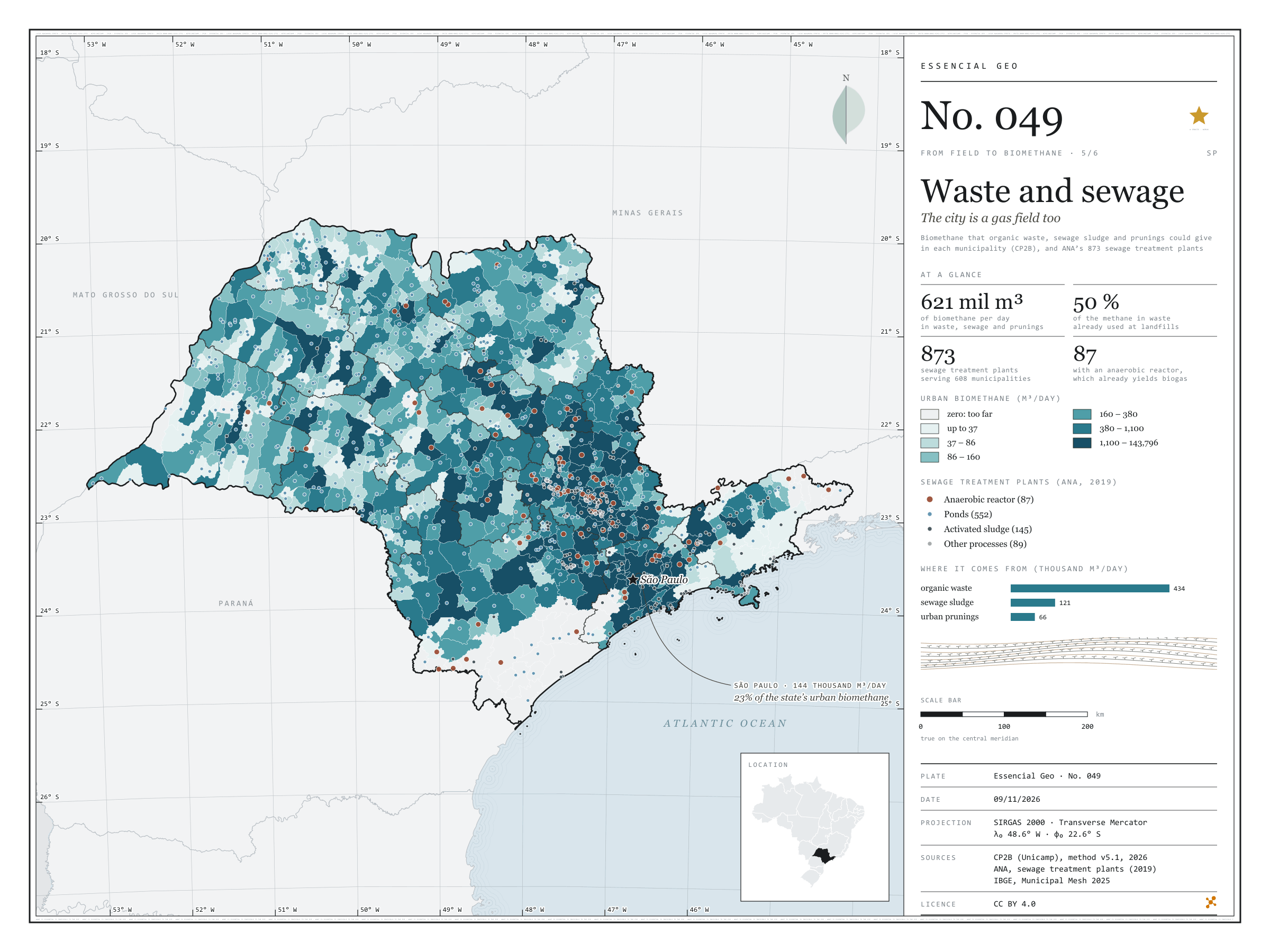
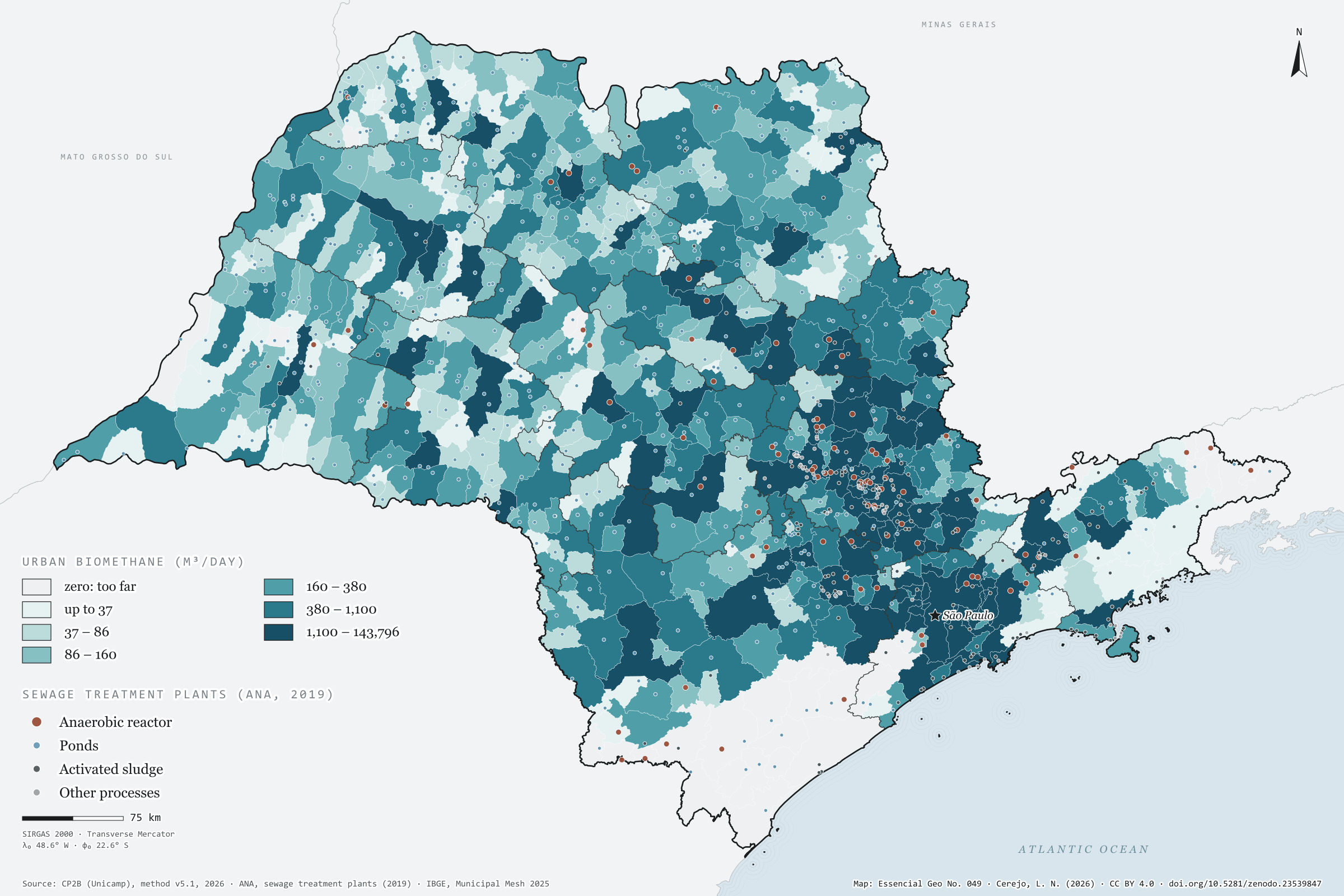
Fig. 049São Paulo state (SP)EPSG:4674Source: CP2B (Unicamp), ANA, IBGE
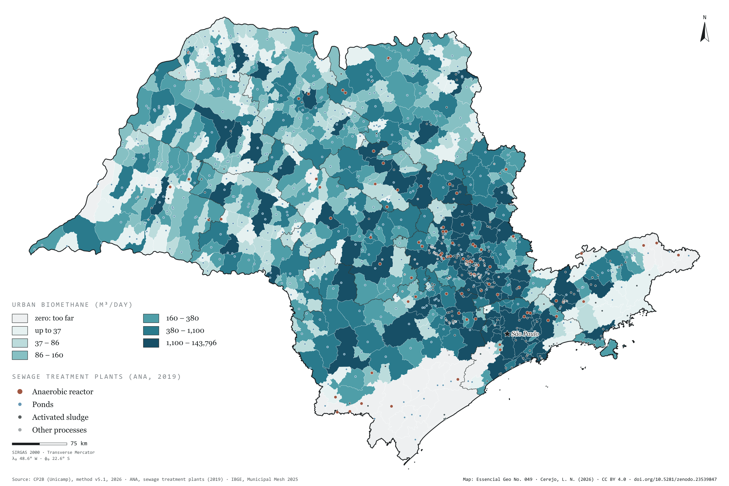
The organic waste, sewage sludge and prunings of São Paulo’s towns and cities could give 621,000 m³ of biomethane a day under the CP2B method: 434,000 from waste, 121,000 from sludge and 66,000 from prunings. That is little next to the countryside, under 4% of the state total, but it lies where almost everyone lives. The city of São Paulo accounts for 23% and its region for 39%. Half the methane the waste could generate is already captured at landfills, and the method deducts that share. The map also shows the 873 sewage treatment plants registered by ANA, serving 608 municipalities. Most treat sewage in ponds (552); 87 use anaerobic reactors, which produce biogas during treatment. Fifth plate of the collection “From field to biomethane”.
Technical record · downloads · citation
At a glance
Where urban biomethane comes from (m³/day)
Organic waste69.8%
Sewage sludge19.5%
Urban prunings10.6%
Waste methane already used
446,934m³ CH₄/day
50% of the 889,450 m³ of methane a day that organic waste could generate, deducted by the method
Largest urban potentials (m³/day)
São Paulo143,796
Campinas28,064
Sorocaba18,094
Piracicaba12,561
São José do Rio Preto12,338
Layers
etespoint873 sewage treatment plants: name, status, process, family, BOD removal and municipalities served
municipiospolygon645 municipalities: biomethane from waste, sludge and prunings (m³/day) and waste methane already used at landfills
regioes_intermediariaspolygon11 intermediate geographic regions
limite_estadualpolygonState boundary
Metadata
Sources
CP2B (Unicamp) — biogas and biomethane potential by municipality, method v5.1 (2026) ANA — Sewage treatment plants (2019 database) (2019) IBGE — Municipal Mesh 2025 (2025)
Biomethane potential of organic waste, sewage sludge and urban prunings at the accessible level of the CP2B method, by municipality, in six quantile classes; ANA sewage treatment plants, one per code, coloured by process family.
The map without a frame, with legend, scale, reference system and credit written on it: ready for papers, lectures and slides. In two versions: with the basemap (neighbours and sea) or only the mapped area, on white.
CEREJO, Lucas Nakamura. Lixo e esgoto: a cidade também é lavoura de gás. Versão 1.0.0. [S. l.]: Zenodo, 2026. Conjunto de dados. DOI: 10.5281/zenodo.23539847. Disponível em: https://doi.org/10.5281/zenodo.23539847. Acesso em: 10 nov. 2026.
Cerejo, L. N. (2026). Lixo e esgoto: a cidade também é lavoura de gás [Waste and sewage: The city is a gas crop too] (Version 1.0.0) [Data set]. Zenodo. https://doi.org/10.5281/zenodo.23539847
@dataset{cerejo2026_lixo_e_esgoto_sp,
  author    = {Cerejo, Lucas Nakamura},
  title     = {Lixo e esgoto: A cidade também é lavoura de gás},
  year      = {2026},
  publisher = {Zenodo},
  version   = {1.0.0},
  doi       = {10.5281/zenodo.23539847},
  url       = {https://doi.org/10.5281/zenodo.23539847},
  language  = {portuguese},
  note      = {English title: Waste and sewage: The city is a gas crop too. Licence CC BY 4.0}
}
Soybean overtook maize, and the straw stayed on the ground
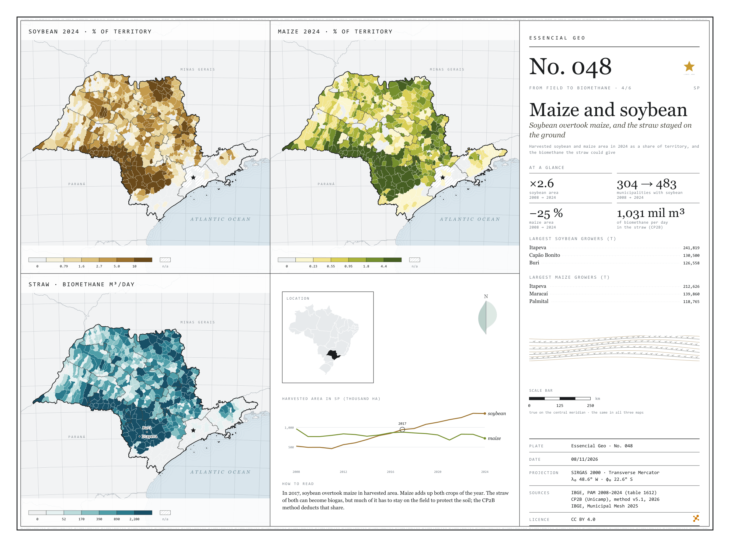
Fig. 048São Paulo state (SP)EPSG:4674Source: IBGE, CP2B (Unicamp)
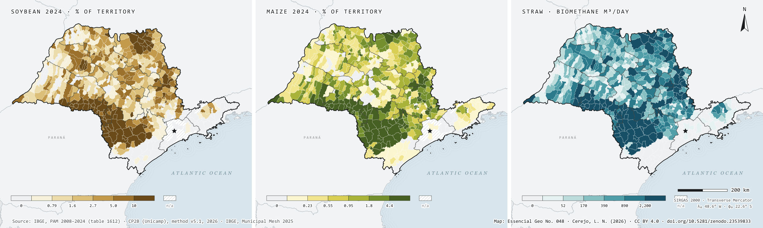
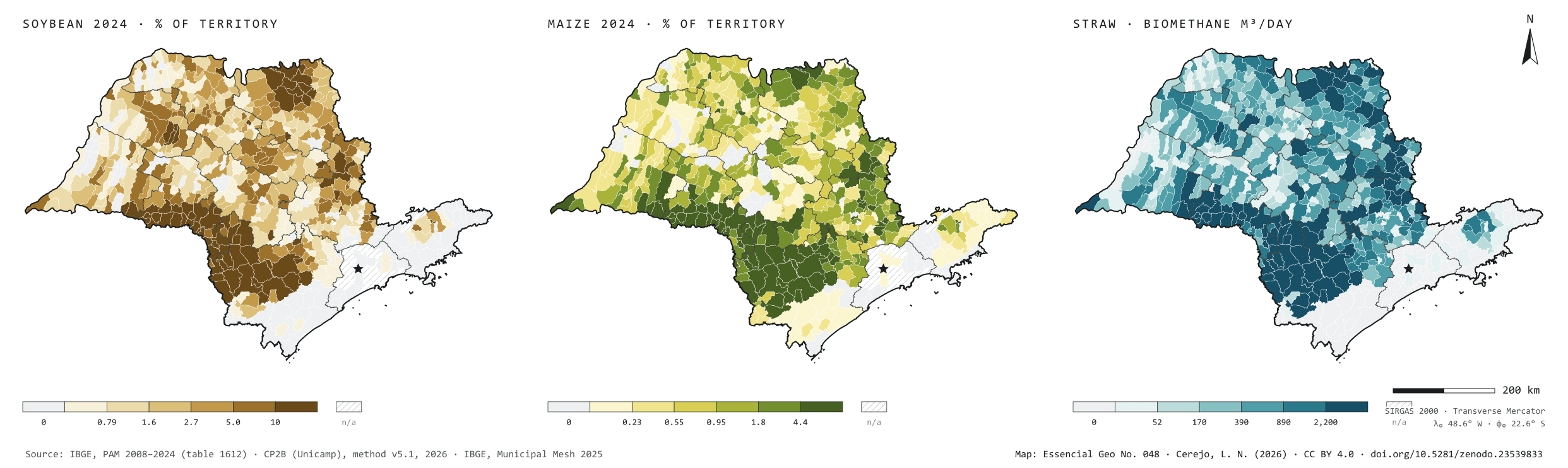
In 2008, São Paulo harvested 525,940 hectares of soybean and 965,907 of maize. In 2024, 1.36 million hectares of soybean, 2.6 times more, and 723,128 of maize, 25% less; soybean overtook maize in 2017. It spread from 304 to 483 municipalities and grew above all in the south of the state. In the Sorocaba region the area went from 82,000 to 468,000 hectares, and Itapeva is the largest grower of both grains. In Ibirarema and Salto Grande, harvested soybean covers almost two thirds of the municipality. The straw of both grains could give 1.03 million m³ of biomethane a day under the CP2B method, 41% of it in the Sorocaba region. That is what remains after leaving on the field the share that protects the soil. Fourth plate of the collection “From field to biomethane”.
Technical record · downloads · citation
At a glance
Harvested soybean area in 2024
1,355,595ha
It was 525,940 ha in 2008; maize fell from 965,907 to 723,128 ha
Biomethane from maize and soybean straw
1,031,325m³/day
Accessible level of the CP2B method, reference scenario: 528,467 from maize and 502,858 from soybean
Largest soybean growers in 2024 (t)
Itapeva241,819
Capão Bonito130,500
Buri126,558
Itaberá103,650
Itapetininga99,000
Layers
municipiospolygon645 municipalities: harvested area and production of soybean and maize in 2008 and 2024, share of territory in 2024 (%) and straw biomethane (m³/day)
regioes_intermediariaspolygon11 intermediate geographic regions
Harvested soybean and maize area from PAM 2024 divided by municipal area, in six quantile classes; straw biomethane potential at the accessible level of the CP2B method, in six quantile classes.
The map without a frame, with legend, scale, reference system and credit written on it: ready for papers, lectures and slides. In two versions: with the basemap (neighbours and sea) or only the mapped area, on white.
CEREJO, Lucas Nakamura. Milho e soja: a soja passou o milho, e a palha ficou no chão. Versão 1.0.0. [S. l.]: Zenodo, 2026. Conjunto de dados. DOI: 10.5281/zenodo.23539833. Disponível em: https://doi.org/10.5281/zenodo.23539833. Acesso em: 10 nov. 2026.
Cerejo, L. N. (2026). Milho e soja: a soja passou o milho, e a palha ficou no chão [Maize and soybean: Soybean overtook maize, and the straw stayed on the ground] (Version 1.0.0) [Data set]. Zenodo. https://doi.org/10.5281/zenodo.23539833
@dataset{cerejo2026_milho_e_soja_sp,
  author    = {Cerejo, Lucas Nakamura},
  title     = {Milho e soja: A soja passou o milho, e a palha ficou no chão},
  year      = {2026},
  publisher = {Zenodo},
  version   = {1.0.0},
  doi       = {10.5281/zenodo.23539833},
  url       = {https://doi.org/10.5281/zenodo.23539833},
  language  = {portuguese},
  note      = {English title: Maize and soybean: Soybean overtook maize, and the straw stayed on the ground. Licence CC BY 4.0}
}
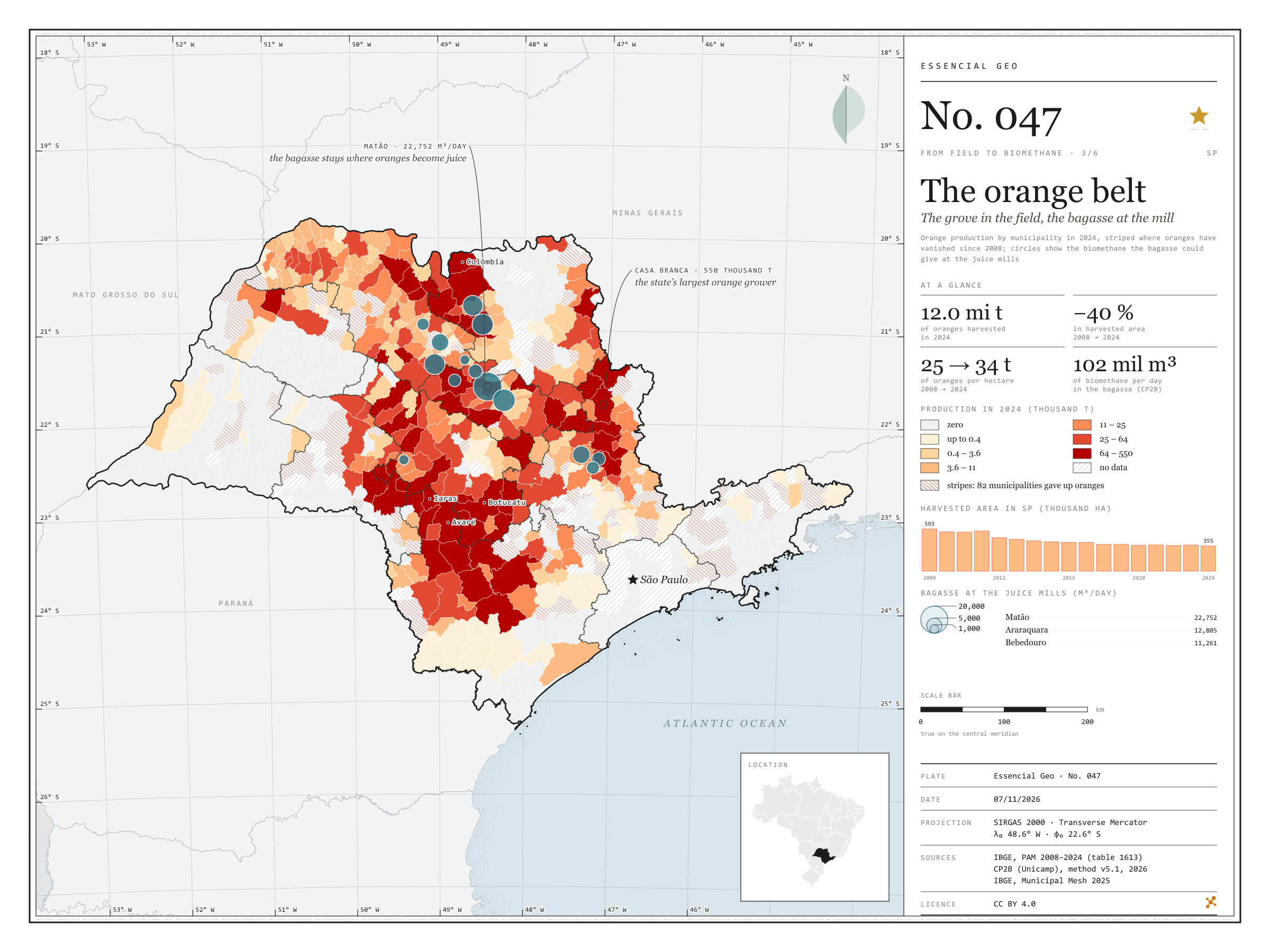
Fig. 047São Paulo state (SP)EPSG:4674Source: IBGE, CP2B (Unicamp)
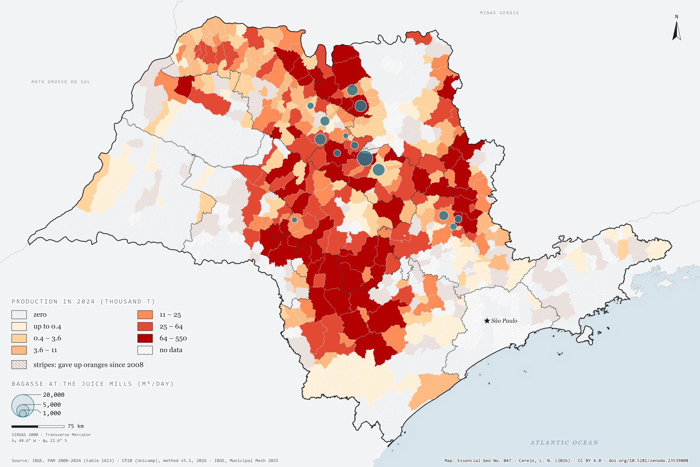
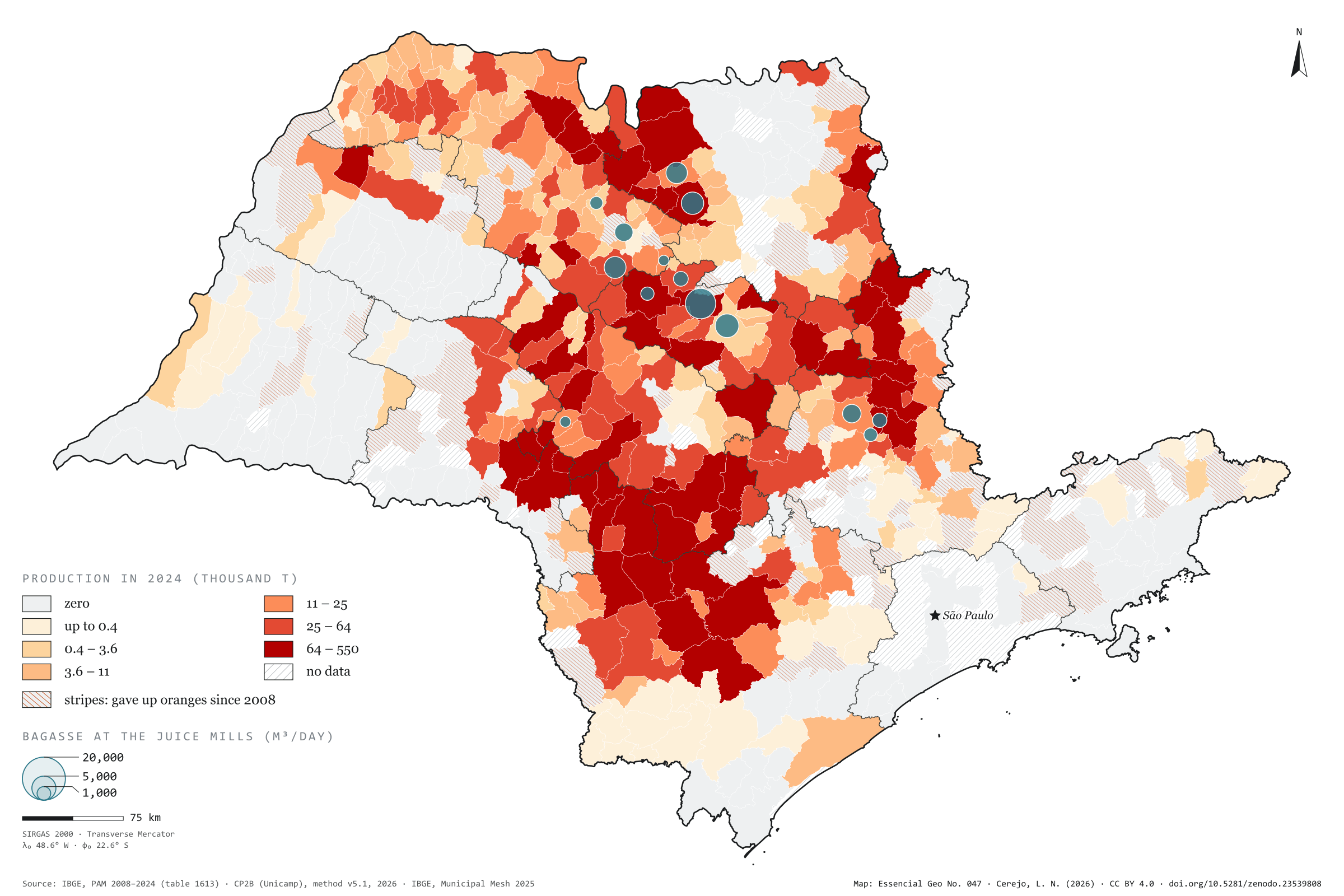
São Paulo harvested 12.0 million tonnes of oranges in 2024, from 354,562 hectares. In 2008 it was 14.5 million tonnes from 592,566 hectares: the area fell by 40%, and each hectare now gives 34 tonnes instead of 25. The belt has also moved south-west. The Araraquara region harvested 3.4 million tonnes and now harvests 1.2; the Sorocaba region rose from 1.0 to 2.4 million and is the state’s largest. Casa Branca leads, with 550,000 tonnes, followed by Botucatu and Avaré, and 82 municipalities have given up oranges. The bagasse, however, stays where the fruit becomes juice. The CP2B method places it in 14 municipalities with mills, and Matão, which harvests 108,000 tonnes, receives the largest potential: 22,752 m³ of biomethane a day, out of 101,834. Third plate of the collection “From field to biomethane”.
Technical record · downloads · citation
At a glance
Orange production in 2024
12,002,362t
In 2008 it was 14,537,610 t, harvested from 592,566 ha; in 2024, from 354,562 ha
Biomethane from orange bagasse
101,834m³/day
Accessible level of the CP2B method, reference scenario, in 14 municipalities with juice mills
Largest growers in 2024 (t)
Casa Branca550,000
Botucatu436,780
Avaré414,710
Iaras346,800
Colômbia337,621
Layers
bagaco_nas_fabricaspoint14 municipalities that receive the bagasse in the CP2B method, with the biomethane (m³/day)
municipiospolygon645 municipalities: harvested area and orange production in 2008 and 2024, share of territory, whether oranges were given up, and bagasse biomethane
regioes_intermediariaspolygon11 intermediate geographic regions
Orange production from PAM 2024 by municipality in six quantile classes; stripes where there was harvested area in 2008 and none in 2024; circles with the bagasse biomethane potential at the accessible level of the CP2B method, allocated to the juice mills.
The map without a frame, with legend, scale, reference system and credit written on it: ready for papers, lectures and slides. In two versions: with the basemap (neighbours and sea) or only the mapped area, on white.
CEREJO, Lucas Nakamura. O cinturão da laranja: o pomar no campo, o bagaço na fábrica. Versão 1.0.0. [S. l.]: Zenodo, 2026. Conjunto de dados. DOI: 10.5281/zenodo.23539808. Disponível em: https://doi.org/10.5281/zenodo.23539808. Acesso em: 10 nov. 2026.
Cerejo, L. N. (2026). O cinturão da laranja: o pomar no campo, o bagaço na fábrica [The orange belt: The grove in the field, the bagasse at the mill] (Version 1.0.0) [Data set]. Zenodo. https://doi.org/10.5281/zenodo.23539808
@dataset{cerejo2026_laranja_sp,
  author    = {Cerejo, Lucas Nakamura},
  title     = {O cinturão da laranja: O pomar no campo, o bagaço na fábrica},
  year      = {2026},
  publisher = {Zenodo},
  version   = {1.0.0},
  doi       = {10.5281/zenodo.23539808},
  url       = {https://doi.org/10.5281/zenodo.23539808},
  language  = {portuguese},
  note      = {English title: The orange belt: The grove in the field, the bagasse at the mill. Licence CC BY 4.0}
}
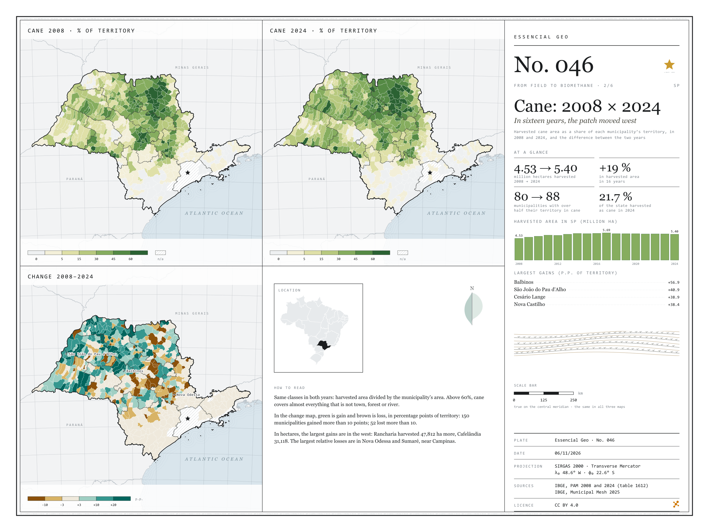
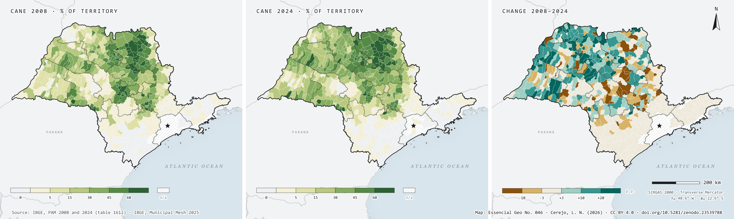
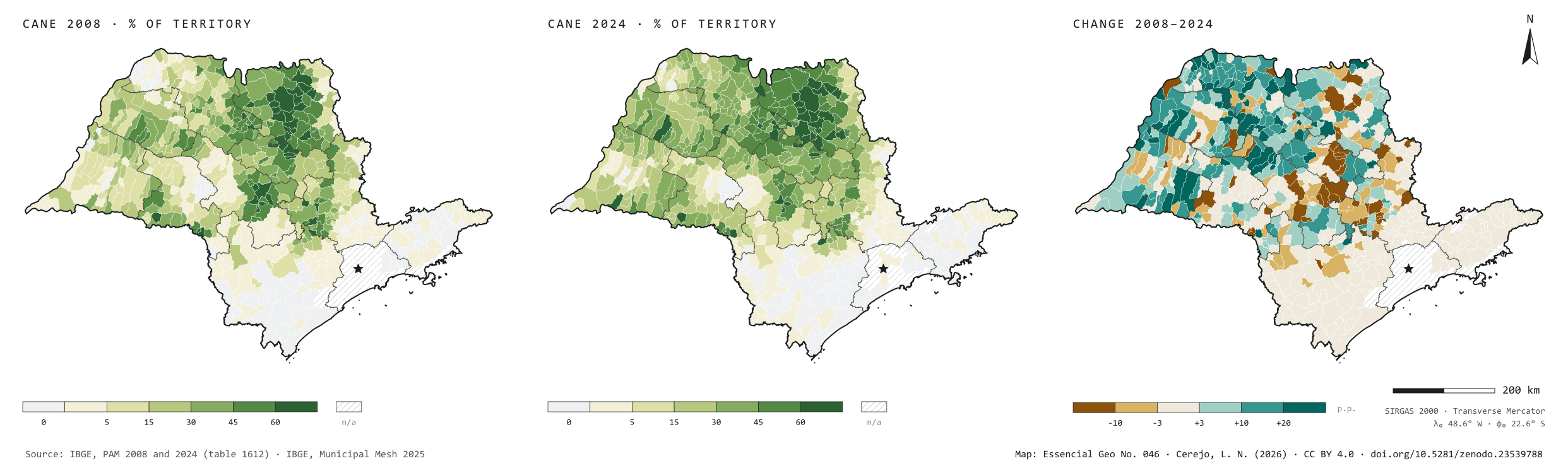
In 2008, São Paulo’s cane fields were harvested over 4.53 million hectares; in 2024, over 5.40 million, 19% more, and cane went from 18.3% to 21.7% of the state’s territory. Harvested area peaked in 2017, at 5.69 million hectares, and has been slowly receding since. The plate sets the two years side by side, with the same classes, and maps the difference: 150 municipalities gained more than 10 percentage points of territory under cane, 104 of them in the São José do Rio Preto, Araçatuba and Presidente Prudente regions, in the west; Rancharia harvested 47,812 hectares more. The Campinas region was the only one to lose much: 63,632 hectares fewer, with the steepest falls in Nova Odessa and Sumaré. Second plate of the collection “From field to biomethane”.
Technical record · downloads · citation
At a glance
Harvested area in 2024
5,398,676ha
It was 4,530,784 ha in 2008: 19% more in sixteen years
Municipalities that gained over 10 p.p.
150
Another 52 lost more than 10 percentage points of territory under cane
Largest gains in harvested area, 2008–2024 (ha)
Rancharia47,812
Cafelândia31,118
José Bonifácio28,000
Martinópolis25,500
Mirandópolis23,000
Layers
municipiospolygon645 municipalities: harvested area and production of cane in 2008 and 2024, share of territory in each year (%) and change (p.p.)
regioes_intermediariaspolygon11 intermediate geographic regions
Harvested cane area from PAM in 2008 and 2024 divided by municipal area, in the same six classes for both years; the change is given in percentage points of territory.
The map without a frame, with legend, scale, reference system and credit written on it: ready for papers, lectures and slides. In two versions: with the basemap (neighbours and sea) or only the mapped area, on white.
CEREJO, Lucas Nakamura. Cana: 2008 × 2024: em dezesseis anos, a mancha andou para o oeste. Versão 1.0.0. [S. l.]: Zenodo, 2026. Conjunto de dados. DOI: 10.5281/zenodo.23539788. Disponível em: https://doi.org/10.5281/zenodo.23539788. Acesso em: 10 nov. 2026.
Cerejo, L. N. (2026). Cana: 2008 × 2024: em dezesseis anos, a mancha andou para o oeste [Cane: 2008 × 2024: In sixteen years, the patch moved west] (Version 1.0.0) [Data set]. Zenodo. https://doi.org/10.5281/zenodo.23539788
@dataset{cerejo2026_cana_2008_2024_sp,
  author    = {Cerejo, Lucas Nakamura},
  title     = {Cana: 2008 × 2024: Em dezesseis anos, a mancha andou para o oeste},
  year      = {2026},
  publisher = {Zenodo},
  version   = {1.0.0},
  doi       = {10.5281/zenodo.23539788},
  url       = {https://doi.org/10.5281/zenodo.23539788},
  language  = {portuguese},
  note      = {English title: Cane: 2008 × 2024: In sixteen years, the patch moved west. Licence CC BY 4.0}
}
Fig. 045São Paulo state (SP)EPSG:4674Source: MapBiomas, IBGE
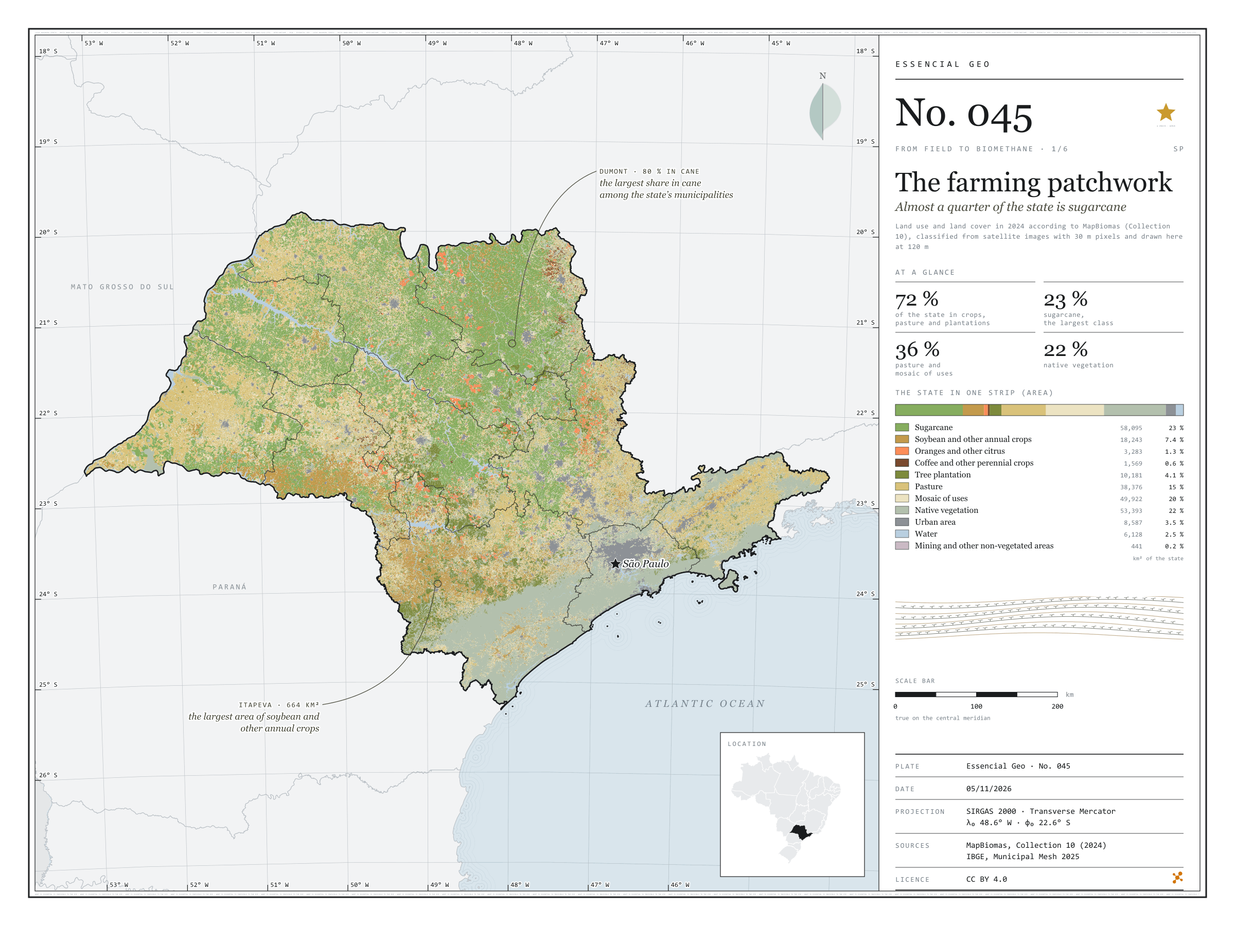
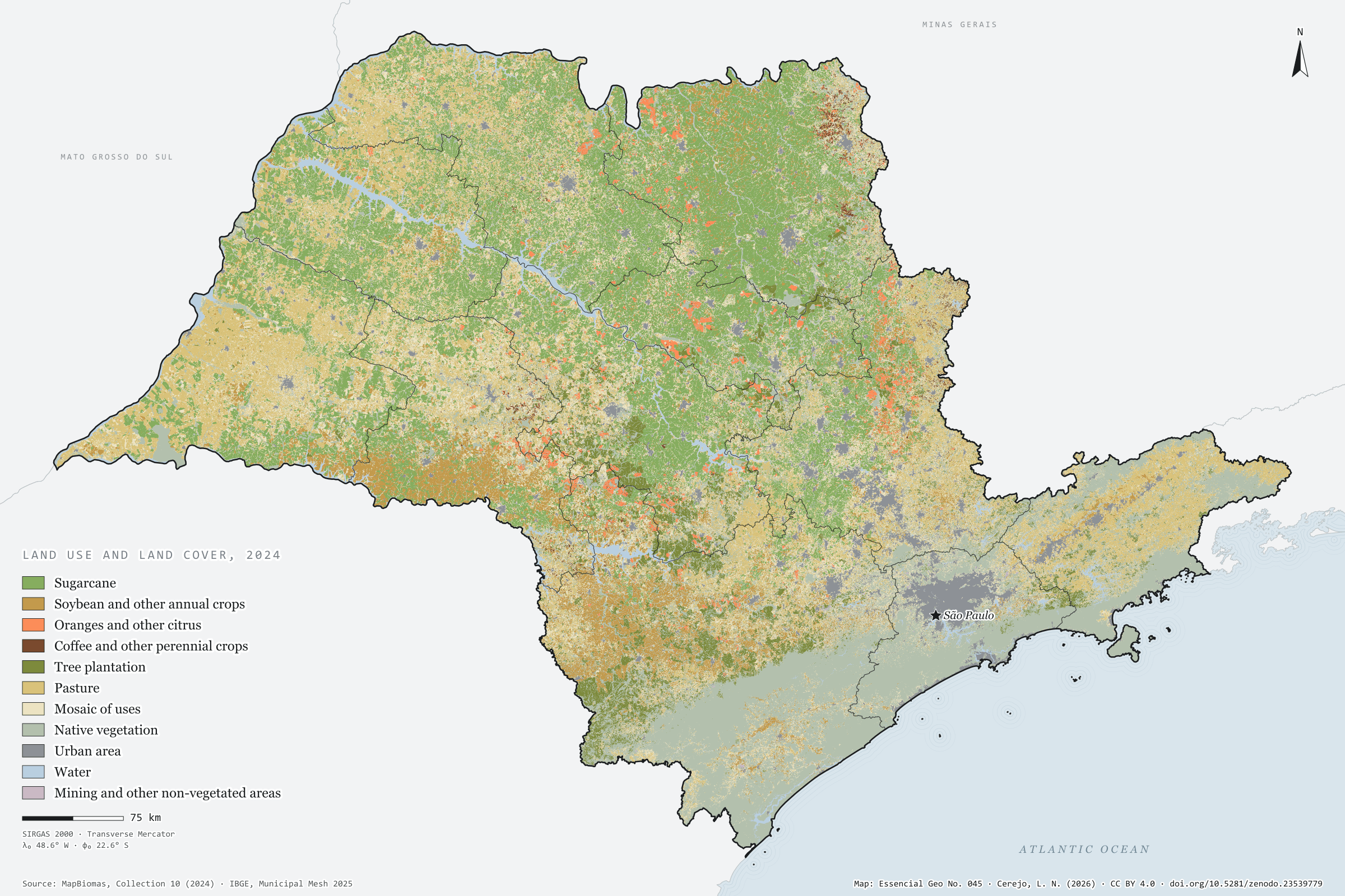
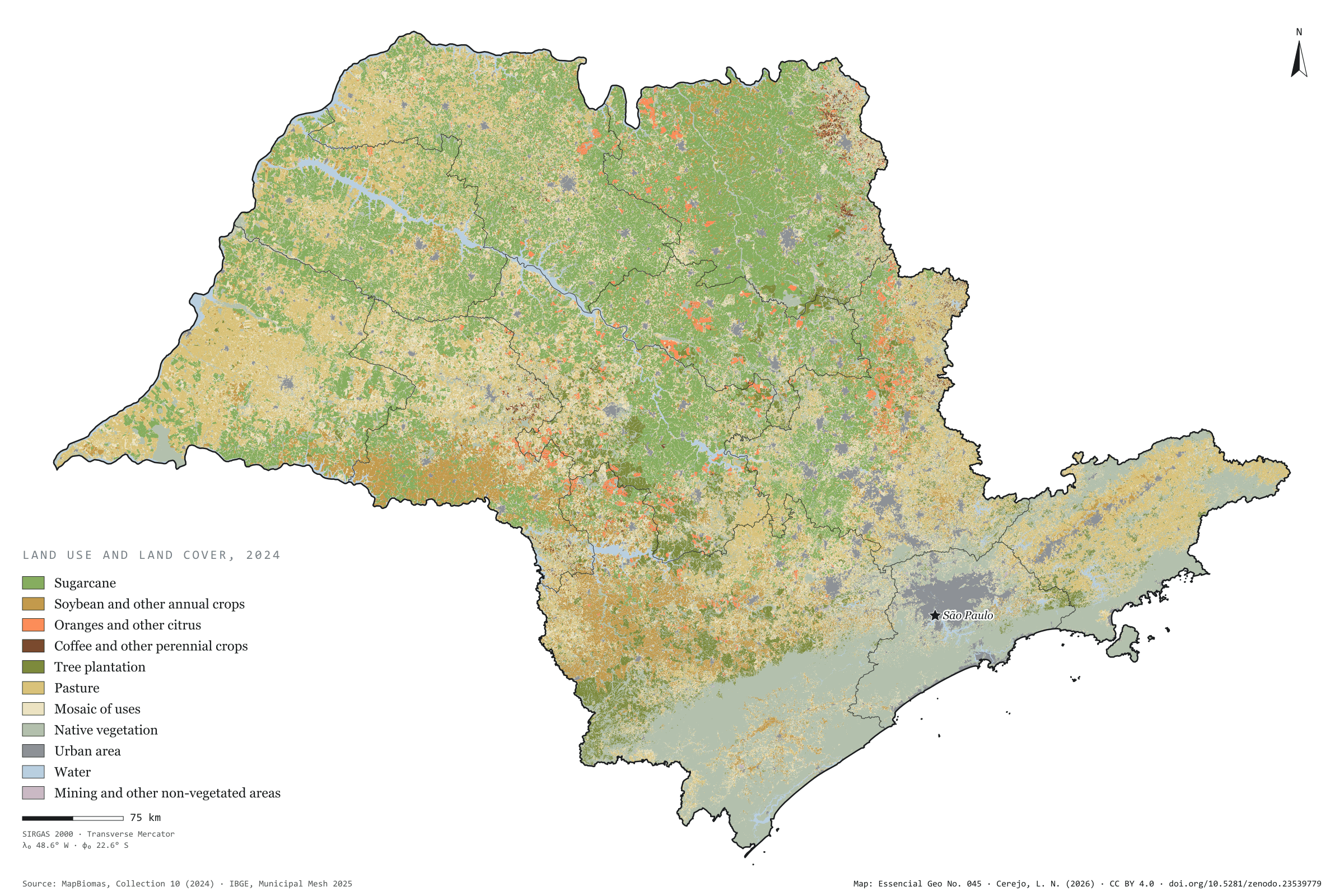
In 2024, 72% of São Paulo’s territory was cropland, pasture, tree plantation or a mosaic of these uses, according to MapBiomas. Sugarcane is the largest class: 58,000 km², almost a quarter of the state, and the leading use in 255 of the 645 municipalities. In the Ribeirão Preto region it covers half the land, and in Dumont, 80%. Soybean and other annual crops add up to 7%, mostly in the south, in the Marília region and around Itapeva. Pasture, at 15%, dominates the west: it covers 36% of the Presidente Prudente region. Oranges, coffee and other perennial crops take up less than 2%. Native vegetation, 22% of the state, lies mostly in the Serra do Mar and the Ribeira valley. First plate of the collection “From field to biomethane”, which follows the crops to the gas their residues could give.
Technical record · downloads · citation
At a glance
The state by land use (km²)
Sugarcane23.4%
Native vegetation21.5%
Mosaic of uses20.1%
Pasture15.5%
Soybean and other annual crops7.3%
Tree plantation4.1%
Urban area3.5%
Water2.5%
Citrus, coffee and other perennials2%
Other non-vegetated areas0.2%
Largest share of the municipality in sugarcane (%)
Dumont80
Guariba78
Pontal77
Dobrada76
Ariranha75
Layers
municipiospolygon645 municipalities: area (km²) and share of the municipality (%) of each of the eleven classes, total of farming uses and class with the largest area
regioes_intermediariaspolygon11 intermediate geographic regions
MapBiomas 2024 classification (Collection 10), 30 m pixels, grouped into eleven classes; areas by municipality counted on the 30 m pixels, on the GRS80 ellipsoid; map drawn with the most frequent class in blocks of 4 × 4 pixels (120 m).
The map without a frame, with legend, scale, reference system and credit written on it: ready for papers, lectures and slides. In two versions: with the basemap (neighbours and sea) or only the mapped area, on white.
CEREJO, Lucas Nakamura. O tabuleiro agrícola: quase um quarto do estado é cana. Versão 1.0.0. [S. l.]: Zenodo, 2026. Conjunto de dados. DOI: 10.5281/zenodo.23539779. Disponível em: https://doi.org/10.5281/zenodo.23539779. Acesso em: 10 nov. 2026.
Cerejo, L. N. (2026). O tabuleiro agrícola: quase um quarto do estado é cana [The farming patchwork: Almost a quarter of the state is sugarcane] (Version 1.0.0) [Data set]. Zenodo. https://doi.org/10.5281/zenodo.23539779
@dataset{cerejo2026_tabuleiro_agricola_sp,
  author    = {Cerejo, Lucas Nakamura},
  title     = {O tabuleiro agrícola: Quase um quarto do estado é cana},
  year      = {2026},
  publisher = {Zenodo},
  version   = {1.0.0},
  doi       = {10.5281/zenodo.23539779},
  url       = {https://doi.org/10.5281/zenodo.23539779},
  language  = {portuguese},
  note      = {English title: The farming patchwork: Almost a quarter of the state is sugarcane. Licence CC BY 4.0}
}